A smooth, lens-like cloud sitting above a rapidly growing tower can look almost artificial. This is a pileus cloud—a short-lived cap that forms when rapidly rising air pushes a moist layer above it upward, causing that displaced air to expand, cool and condense.
Pileus clouds can form above strong thunderstorms, volcanic plumes and, under the right conditions, wildfire-generated convective clouds. They are especially useful teaching examples because they connect several core ideas in atmospheric science: buoyancy, convection, pressure, expansion, cooling, condensation and cloud microphysics.
What exactly is a pileus cloud?
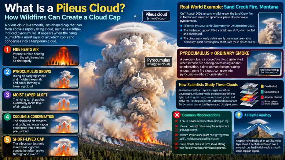
The word pileus comes from Latin for a cap. In meteorology, a pileus is a smooth cloud that briefly forms above a rapidly developing cumulus or cumulonimbus turret. It is not a separate storm sitting independently above the cloud below. Instead, it forms because the growing convection physically displaces a layer of moist air above it.
As that moist layer is forced upward, surrounding pressure decreases. The air expands and cools. If it cools to saturation, water vapour condenses into tiny cloud droplets, producing the characteristic smooth cap.
How can a wildfire create one?
Wildfires can generate intense surface heating. That heating makes air near the fire buoyant, so it rises rapidly. If the updraft is strong enough and contains sufficient moisture, a convective cloud called pyrocumulus can develop above the smoke plume.
The process can be broken into five stages.
1. Fire heats the air
A large, intense fire transfers heat to the air above it. The heated air becomes less dense than its surroundings and accelerates upward.
2. A pyrocumulus tower grows
As the rising air climbs, pressure decreases. The air expands and cools. When it reaches saturation, water vapour condenses and a cloud forms. The Met Office describes pyrocumulus as a cumulus cloud generated over an intense source of surface heat such as a forest fire or volcanic eruption.
3. The rising turret reaches a moist layer
The convective tower does not rise through a perfectly uniform atmosphere. It may encounter a relatively moist layer above it. The rapidly growing turret can push that layer upward.
4. The lifted air cools and condenses
Because atmospheric pressure falls with height, the displaced air expands as it rises. Expansion causes cooling. If the air reaches its saturation point, condensation produces a thin, smooth cloud above the turret: the pileus.
5. The cap may disappear quickly
Strong convection can continue rising through the pileus. The cloud cap may therefore be visible for only a short time before the underlying turret grows into and beyond it.
A 2026 wildfire case study
NASA Earth-observation researchers highlighted a striking 2026 example associated with vigorous wildfire convection in the western United States. Aircraft observations showed how a fast-rising fire-generated cloud could briefly produce a smooth pileus cap as a moist layer aloft was lifted and cooled.
The key lesson is not the individual fire itself, but the atmospheric process it reveals: a pileus cloud is evidence that the underlying updraft is strong enough to deform the air above it on a short timescale.
Pyrocumulus is not the same thing as ordinary smoke
A smoke plume contains gases, aerosols and particles produced by combustion. A pyrocumulus cloud, by contrast, is a cloud of condensed water droplets or ice generated by convection associated with the fire.
Smoke can influence cloud development by providing particles that water can condense onto, but the main engine of pyrocumulus formation is the intense heat and upward motion produced by the fire.
The National Weather Service and Met Office both describe pyrocumulus as a convective cloud driven by strong surface heating. If convection becomes sufficiently deep and unstable, a pyrocumulus can grow into a pyrocumulonimbus, a fire-generated thunderstorm capable of producing lightning, strong winds and other hazardous weather.
Does a pileus cloud mean a fire will become a thunderstorm?
No. A pileus tells us that the underlying convection is vigorous, but it does not guarantee that the cloud will develop into a thunderstorm.
Further development depends on atmospheric instability, moisture through a sufficient depth of the atmosphere, entrainment of surrounding air, wind shear and the continued strength of the heat source. A pileus is therefore a clue about strong upward motion, not a deterministic forecast.
Why does rising air cool?
This is one of the most important ideas in meteorology. Atmospheric pressure decreases with height. When a parcel of air rises into lower pressure, it expands. Expansion requires energy, so the air's temperature falls even if it does not lose much heat directly to its surroundings.
This process is called adiabatic cooling. When the rising air cools to its dew point, water vapour begins to condense. Millions of tiny droplets together form a visible cloud.
That same principle explains many ordinary cumulus clouds, clouds over mountains and the temporary cap of a pileus.
A useful analogy: air flowing over a mountain
Imagine moist air being pushed upward over a mountain. As it rises, it expands and cools, sometimes producing a smooth cloud near the summit.
A pileus is not identical to a mountain cloud, but the analogy helps: in both cases, air is forced upward, cools through expansion and can reach saturation. The difference is that the “obstacle” beneath a pileus is a rapidly growing convective turret rather than solid terrain.
How scientists observe wildfire clouds
Researchers use several complementary tools to study fire-generated clouds.
- Visible imagery shows cloud shape, smoke plumes and plume structure.
- Infrared observations help estimate cloud-top temperatures and distinguish different thermal features.
- Shortwave-infrared measurements can help detect intense fire activity and separate active burning from surrounding terrain.
- Research aircraft can directly sample smoke, aerosols, gases, temperature, humidity and cloud properties.
- Weather radar can track deep convective development and, in some cases, precipitation or lofted debris.
Combining these measurements helps scientists connect what is happening at the surface with cloud processes several kilometres above the fire.
Why are pileus clouds scientifically useful?
Pileus clouds provide a visible marker of strong vertical motion. Their appearance can reveal that a developing cloud is interacting rapidly with a moist layer above it.
They can also offer researchers a short-lived natural experiment. Because the cap may form and disappear within minutes, repeated satellite, aircraft or ground-based observations can reveal how fast the convective system is evolving.
Common misconceptions
“A pileus is a separate storm sitting on top of another cloud.”
No. It forms because the rapidly rising cloud below displaces and cools a moist layer above it.
“Wildfire smoke automatically creates pileus clouds.”
No. Smoke alone is not enough. Vigorous upward motion, sufficient moisture and the right temperature structure are needed.
“A pileus means a pyrocumulonimbus is inevitable.”
No. It indicates strong convection, but thunderstorm development requires additional atmospheric conditions.
“Pileus clouds only occur above wildfires.”
No. They can also occur above rapidly growing ordinary convection and strong volcanic plumes.
“The cloud cap is made of smoke.”
Not necessarily. A pileus is primarily a cloud produced by condensation. Smoke may be present nearby in wildfire cases, but the smooth cap itself forms from condensed atmospheric moisture.
Practical application: how to read a wildfire-cloud image
When looking at a photograph or satellite image of a large wildfire plume, ask four questions:
- Is the feature mainly smoke, or is there a bright convective cloud above it?
- Does the cloud have rapidly growing cauliflower-like turrets?
- Is there a smooth cap immediately above a turret that could be a pileus?
- Is there evidence of much deeper development, such as an anvil, that could indicate pyrocumulonimbus?
Images alone cannot answer every question, so meteorologists combine them with temperature, humidity, radar, satellite and aircraft observations.
Key takeaways
- A pileus cloud is a smooth, temporary cap that can form above rapidly rising convection.
- Wildfire heating can generate strong updrafts and pyrocumulus clouds.
- A pileus forms when a growing cloud pushes a moist layer upward, causing expansion, cooling and condensation.
- Pileus clouds are often short-lived because the underlying convection can quickly grow through them.
- They indicate vigorous upward motion but do not guarantee a thunderstorm.
- Pyrocumulus is a true cloud produced by condensation, not simply another name for smoke.
Frequently asked questions
How long does a pileus cloud last?
Often only minutes. Its lifetime depends on how rapidly the underlying cloud grows and how the surrounding moisture and winds evolve.
Can you see pileus clouds without a wildfire?
Yes. They can form above rapidly growing cumulus or cumulonimbus clouds and above some volcanic plumes.
What is the difference between pyrocumulus and pyrocumulonimbus?
Pyrocumulus is a fire-generated convective cloud. Pyrocumulonimbus is a much deeper fire-generated thunderstorm that can produce lightning and other severe weather.
Does a pileus cloud contain ice?
It can, depending on its altitude and temperature. At warmer levels it may consist mainly of liquid droplets; at colder levels it may contain ice crystals.