

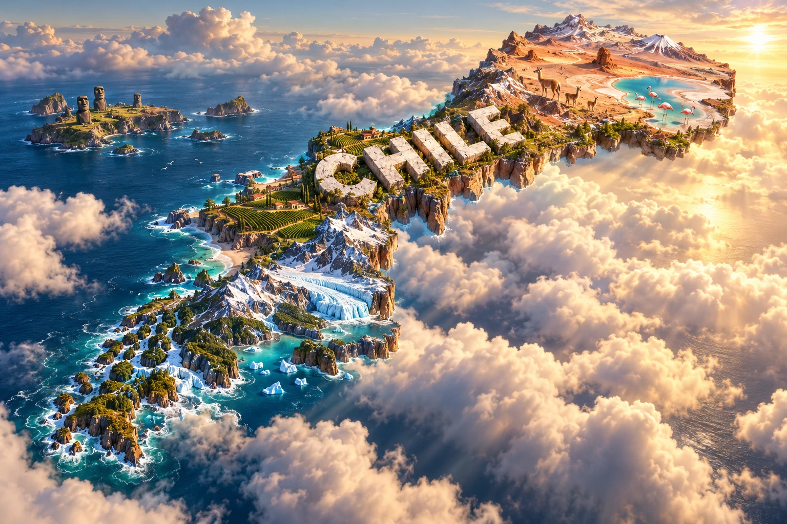
Chile is one of the world's most geographically elongated countries: a narrow strip between the Andes and Pacific extending more than 4,000 kilometers from the dry subtropics toward stormy subantarctic seas. Its landscapes include the Atacama Desert, Mediterranean-climate valleys, temperate rainforest, volcanoes, glaciers, fjords and distant Pacific islands.
That variety is not accidental. An oceanic tectonic plate descends beneath South America along Chile's coast, raising mountains and producing powerful earthquakes and volcanoes. Ocean currents, high relief, latitude and prevailing winds then divide the country into striking climate zones.
1. Where Is Chile?
Chile occupies the southwestern edge of South America. Peru borders it to the north, Bolivia to the northeast and Argentina along most of the east. The Pacific Ocean lies to the west and south. Across the far-southern Drake Passage lies Antarctica.
Santiago, the capital and largest metropolitan center, lies in the Central Valley between the coastal ranges and Andes. Valparaíso is a historic Pacific port and seat of the National Congress. Other important cities include Concepción, Antofagasta, Viña del Mar, Temuco, Puerto Montt, La Serena and Punta Arenas.
The republic also includes Pacific islands. Rapa Nui, or Easter Island, lies about 3,700 kilometers west of mainland Chile and belongs culturally and geographically to Polynesia. The Juan Fernández Archipelago is closer to the continent but still isolated. Chile asserts a claim in Antarctica, held subject to the Antarctic Treaty system; ordinary area figures generally describe its South American and island territory, not the claimed Antarctic sector.
2. Quick Country Facts
- Official name: Republic of Chile
- Capital: Santiago
- Region: South America, with Pacific island territories
- Area: Approximately 756,102 square kilometers, excluding the Antarctic claim
- Population: Projected at approximately 20.15 million in mid-2026 by Chile's National Statistics Institute
- Currency: Chilean peso (CLP)
- Official and majority language: Spanish
- Indigenous languages: Include Mapudungun, Aymara, Rapa Nui, Quechua and others
- Time zones: Mainland and southern islands generally use UTC−4 standard time; Rapa Nui uses UTC−6, with seasonal and regional clock changes
- Highest point: Nevado Ojos del Salado, approximately 6,893 meters
- Longest river: Loa River
- Coast: Pacific Ocean, with an exceptionally indented far south
Time rules can change and are not uniform across all territory. Population totals are projections based on census and demographic evidence rather than a live count.
3. Geography and Landscape
Northern Chile contains the Atacama, among Earth's driest non-polar deserts. The coastal range rises sharply beside a narrow shore, while inland basins hold salt flats and mineral deposits. Farther east, the high Altiplano contains volcanoes, grasslands, salt lakes and wetlands where flamingos feed.
The Norte Chico, or semi-arid “little north,” forms a transition of transverse valleys between desert and central Chile. Rivers descending from the Andes support towns, orchards and reservoirs, but drought makes water management increasingly difficult.
Central Chile has a Mediterranean-type climate with wet winters and dry summers. The Central Valley contains Santiago and much of the population, industry, vineyards and intensive agriculture. It is bordered by the Chilean Coast Range to the west and the much higher Andes to the east.
Southward, rainfall increases. The Lake District contains glacial lakes, active volcanoes and temperate forests dominated in places by southern beech and other native trees. Chiloé is separated from the mainland by channels and has its own island environments and cultural history.
Patagonia and the far south form a maze of mountains, ice fields, fjords, channels and islands. The Northern and Southern Patagonian Ice Fields feed glaciers that descend into valleys and tidewater. East of the Andes, rain-shadow steppe is much drier than the storm-exposed Pacific side.
4. Why Does Chile Look Like This?
Most of Chile sits above a convergent plate boundary. The dense oceanic Nazca Plate moves beneath the South American Plate along the Peru–Chile Trench. Compression shortens and thickens the continental crust, helping raise the Andes. Water carried down with the oceanic plate promotes melting at depth, feeding the volcanic arc.
The same plate boundary stores enormous strain. When a locked section suddenly slips, it produces a megathrust earthquake and may displace the seafloor enough to generate a tsunami. The 1960 Valdivia earthquake, magnitude 9.5, remains the largest instrumentally recorded earthquake. Not every part of Chile has identical risk, but earthquake-resistant design and preparedness are national priorities.
Northern dryness results from several interacting controls. The subtropical high-pressure belt suppresses rising air; the cold Humboldt, or Peru, Current stabilizes the lower atmosphere and limits rain; and the Andes block moisture arriving from the east. Coastal fog called camanchaca can support plants even where measurable rain is exceptionally rare.
Patagonia shows the opposite moisture pattern. Westerly winds carry Pacific moisture onto mountains, producing heavy rain and snow on western slopes. Air descending east of the Andes becomes warmer and drier, creating steppe.
During recent ice ages, glaciers filled southern valleys and deepened existing depressions. When ice retreated and sea level rose, seawater flooded many glacial troughs, creating fjords and channels. Modern glaciers continue to erode rock, while many are losing mass as climate warms.
5. Climate
Chile's extreme length produces several major climate zones. The far north is hyperarid at low elevations but colder in the Altiplano, where summer storms sometimes arrive from the tropical interior. High altitude creates intense sunlight, freezing nights and occasional snow.
Central Chile has cool, wetter winters and warm, dry summers. This pattern favors grapes, fruit and other crops but also creates wildfire risk at the end of dry seasons. A prolonged regional “megadrought” has intensified pressure on rivers, reservoirs, farms and ecosystems.
Southern Chile is cooler and wetter, with rainfall distributed across much of the year. The far-western archipelagos receive frequent storms, whereas eastern Patagonia is windy and relatively dry. Mountain conditions change rapidly with elevation.
Rapa Nui has a mild subtropical oceanic climate, distinct from mainland zones at the same administrative level. The Humboldt Current cools much of mainland Chile's coast and supports marine productivity.
Climate change is affecting water supply, glacier mass, wildfire conditions, coastal hazards and marine ecosystems. El Niño and La Niña also shift rainfall, temperature and ocean productivity from year to year.
6. Wildlife and Ecosystems
High Andean wetlands of the north support three flamingo species found in Chile: Andean, James's and Chilean flamingos. They feed and breed at particular salt lakes and wetlands, not throughout the Atacama. Vicuñas, viscachas, foxes and high-altitude birds occupy surrounding puna habitats.
Guanacos range across parts of the north and are especially characteristic of Patagonian steppe. In Patagonia National Park they share the landscape with pumas, condors, foxes and the endangered huemul, or south Andean deer. Distribution and abundance differ by region.
Central Chile is part of a biodiversity hotspot with many endemic plants and animals. Mediterranean shrubland known as matorral has been heavily altered by cities, farming, invasive species and fire. The Chilean palm survives in limited central valleys.
Southern temperate forests support pudú deer, monito del monte, Darwin's fox in restricted locations and distinctive birds. Coastal waters contain Humboldt penguins in the north and center, marine otters, sea lions, whales and abundant seabirds. The Humboldt Current brings nutrient-rich deep water toward the surface, supporting plankton, fisheries and food webs.
Island isolation produced high endemism. The Juan Fernández firecrown and many island plants occur nowhere else. Introduced animals and plants can be especially damaging on islands. Protected areas cover desert, mountains, forest, steppe, coast and islands, but mining, water extraction, habitat conversion, pollution, invasive species and climate change remain pressures.
7. Famous Landmarks and Natural Features
Atacama Desert and its salt flats demonstrate how extreme aridity, volcanism and closed drainage concentrate salts and minerals. Astronomical observatories use the region's high, dry, dark conditions, though major facilities occupy specific mountaintops rather than the entire desert.
Torres del Paine contains granite towers, sedimentary rocks, glacial lakes, steppe and part of the Southern Patagonian landscape. Ice and erosion exposed the dramatic intrusive granite forms.
Rapa Nui National Park protects moai, ceremonial platforms called ahu, quarries and other parts of a living Indigenous cultural landscape. The moai were created by Polynesian Rapa Nui ancestors; they should not be presented merely as mysterious statues or generic Chilean decoration.
Valparaíso's historic quarter records the port's role on Pacific maritime routes before the Panama Canal changed global shipping. Hillside lifts, stairs and varied architecture grew around steep topography.
The Churches of Chiloé combine European church forms with local timber-building knowledge. Sixteen churches form the UNESCO property, reflecting community traditions across the archipelago.
Humberstone and Santa Laura preserve nitrate-processing settlements in the Atacama. They explain the labor, technology and boom-and-bust economy associated with natural nitrate, not simply picturesque ruins.
Sewell is a former company town built above the El Teniente copper mine on steep Andean slopes. Its stairs and industrial structures document the social and technological history of large-scale mining.
8. People, Languages and Culture
Spanish is the main language, with pronunciation and vocabulary varying by region and social context. Indigenous peoples include Mapuche, Aymara, Diaguita, Quechua, Atacameño or Lickanantay, Rapa Nui, Kawésqar, Yagán and others. Indigenous identities, languages and land relationships remain contemporary, not confined to archaeology.
Mapuche communities are concentrated especially in south-central Chile and urban areas, but are internally diverse. Rapa Nui people maintain Polynesian language, kinship, arts and authority on their island. Northern Andean communities have cross-border cultural histories older than modern states.
Chile declared independence in 1818 after Spanish colonial rule. During the nineteenth century, warfare and state expansion transformed Indigenous territories and incorporated mineral-rich northern provinces. These processes remain important to modern debates about land and identity.
A military coup overthrew President Salvador Allende in 1973. Augusto Pinochet's dictatorship lasted until 1990 and involved systematic human-rights violations, exile and economic restructuring. Democratic government returned in 1990; memory, justice and the dictatorship's institutional legacy remain part of public debate.
Literature has international prominence through writers including Gabriela Mistral and Pablo Neruda, but Chilean culture also includes oral traditions, contemporary fiction, muralism, film and digital arts. Cueca is recognized nationally, while music and dance differ among central, Andean, Mapuche, Chiloé, Patagonian and Rapa Nui contexts.
9. Food
Chile's long coastline makes fish and shellfish important, though species and access vary by region. Pastel de choclo layers a seasoned filling beneath ground fresh corn. Empanada de pino commonly contains beef, onion, egg and olive, with household variations.
Cazuela is a broth-based meal containing meat and large pieces of vegetables such as potato, squash or corn. Curanto, associated especially with Chiloé, traditionally cooks shellfish, meat, potatoes and dumpling-like preparations in an earth oven, though pot versions are also common.
Northern foods use maize, quinoa, potatoes and camelid or other meats in Andean traditions. Central valleys produce fruit, vegetables and wine. Patagonia is associated with lamb in some communities. Rapa Nui cuisine draws on Polynesian crops and marine foods.
10. Economy and Major Industries
Mining is central to Chile's export economy. The country is the world's leading copper producer and an important lithium producer, especially from brines in northern salt flats. These minerals support global electrical and energy technologies but raise questions about water, ecosystems, Indigenous consultation and local value creation.
Services account for most employment and output, including retail, finance, transport, education, health and technology. Manufacturing includes food processing, chemicals, metal products, wood and pulp.
Agriculture uses central and southern climate zones to produce fruit, wine, vegetables, dairy products and other foods. Forestry and pulp are important in south-central regions, where plantation expansion has environmental and social consequences. Salmon aquaculture is concentrated in southern waters; fisheries also depend on Humboldt Current productivity.
The World Bank reported 2.6 percent GDP growth in 2024 and expected a similar rate in 2025, supported by exports, consumption and investment. These dated estimates may be revised. Chile remains a high-income economy but faces slow productivity growth, inequality, regional disparities, water scarcity and exposure to commodity cycles.
11. What the 3D Visual Represents
The Chile artwork combines the Atacama Desert, Andes, Patagonian glaciers, Pacific coast, central vineyards, high-Andean flamingos, guanacos and moai inspired by Rapa Nui. Embedded “CHILE” lettering compresses thousands of kilometers and an offshore Polynesian island into one floating micro-world.
Each element belongs to a particular setting. Flamingos concentrate at suitable northern wetlands. Vineyards are especially important in central valleys. Large ice fields occur in the south. Rapa Nui lies far offshore and is not physically beside Patagonia or the Atacama.
The image is a conceptual artistic composition. The landmarks, wildlife and landscapes are combined for educational visualization and are not shown at their true geographic positions or scale. It is not a satellite map, and the moai remain the cultural heritage of the Rapa Nui people.
12. Interesting Facts About Chile
- Chile extends more than 4,000 kilometers from north to south.
- Its mainland is squeezed between the Pacific and Andes.
- The Nazca Plate subducts beneath South America along most of the coast.
- The 1960 Valdivia earthquake was magnitude 9.5, the largest instrumentally recorded.
- The Atacama is among Earth's driest non-polar deserts.
- Coastal fog supports life in some places with almost no rain.
- Ojos del Salado is the world's highest active volcano and Chile's highest point.
- Mediterranean-climate central Chile contains most of the population.
- Western Patagonia is much wetter than the steppe east of the Andes.
- Glaciers helped carve southern fjords and channels.
- Three flamingo species occur in Chilean high-Andean wetlands.
- Rapa Nui lies about 3,700 kilometers from mainland Chile.
- Chile has seven UNESCO World Heritage properties.
- The Humboldt Current supports major marine food webs and fisheries.
- Copper remains the country's most important mineral export.
13. Short Quiz
-
What tectonic process helps build Chile's Andes? A. The Nazca Plate subducting beneath South America B. Two continents moving directly apart C. Coral reefs lifting the coast D. River sediment alone
-
Why is northern Chile so dry? A. Cold ocean water, stable air and mountain rain shadows interact B. It has no nearby mountains C. Glaciers absorb every cloud D. The Pacific is warmer than all tropical seas
-
Where are Chile's largest glaciers and fjords concentrated? A. Patagonia and the far south B. Central Santiago C. The Altiplano salt flats only D. Rapa Nui
-
Who created the moai? A. Rapa Nui ancestors of Polynesian origin B. Spanish copper miners C. Patagonian glaciers D. Modern astronomers
-
How should the 3D artwork be interpreted? A. As an exact scale map B. As a conceptual combination of distant features C. As proof that vineyards grow beside every glacier D. As a current wildlife census
Answer key: 1-A, 2-A, 3-A, 4-A, 5-B.
14. Related Learning
Suggested internal-link topics:
- Argentina Explained: Andes, Pampas, Patagonia and Culture
- Peru Explained: Andes, Pacific Coast, Amazon and Heritage
- Bolivia Explained: Altiplano, Salt Flats and Indigenous Cultures
- Why Is Chile So Long and Narrow?
- Why Is the Atacama Desert So Dry?
- How Nazca Plate Subduction Shapes Chile
- How Glaciers Carved the Fjords of Patagonia
- Why Chile Has So Many Powerful Earthquakes
- How the Humboldt Current Supports Marine Life
- What the Moai Mean in Rapa Nui Culture
15. Sources
- Chile National Statistics Institute — 2026 population projection
- World Bank — Chile overview
- U.S. Geological Survey — Seismotectonics of the Nazca Plate region
- UNESCO World Heritage Centre — Chile
- UNESCO World Heritage Centre — Rapa Nui National Park
- UNESCO World Heritage Centre — Sewell Mining Town
- CONAF — Los Flamencos National Reserve
- CONAF — Patagonia National Park