

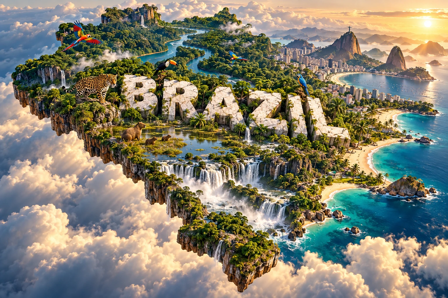
Brazil is South America's largest country and contains much of the Amazon basin, but it is far more than rainforest. Tropical savannas, seasonally flooded wetlands, semi-arid scrub, Atlantic forests, southern grasslands, ancient plateaus and an immense coastline make it one of Earth's most geographically and biologically varied nations.
Water connects many of these landscapes. The Amazon moves more water than any other river system, the Pantanal floods and drains with the seasons, and the Paraná system powers cities and forms Iguaçu Falls. Geography also helps explain why most Brazilians live near the Atlantic rather than deep in the continental interior.
1. Where Is Brazil?
Brazil occupies nearly half of South America and has a long Atlantic coastline. It borders every South American country except Chile and Ecuador: Uruguay, Argentina, Paraguay, Bolivia, Peru, Colombia, Venezuela, Guyana, Suriname and France through French Guiana.
The equator crosses northern Brazil, while the Tropic of Capricorn crosses the southeast and south. This wide latitudinal range contributes to tropical and subtropical climates. The Fernando de Noronha archipelago and several other island groups extend Brazilian territory into the Atlantic.
Brasília is the federal capital, purpose-built on the central plateau and inaugurated in 1960. São Paulo is the largest city and main financial and industrial center. Rio de Janeiro is a major cultural and port city, while Salvador, Belo Horizonte, Recife, Fortaleza, Manaus, Belém, Curitiba, Porto Alegre and other cities anchor distinct regions.
2. Quick Country Facts
- Official name: Federative Republic of Brazil
- Capital: Brasília
- Region: South America
- Area: Approximately 8.51 million square kilometers
- Population: Approximately 213.4 million in Brazil's official 2025 estimate
- Currency: Brazilian real (BRL)
- Official language: Portuguese
- Other languages: Hundreds of Indigenous languages, Brazilian Sign Language (Libras), immigrant-community languages and regional Portuguese varieties
- Time zones: Four standard time zones, from UTC−5 to UTC−2
- Highest point: Pico da Neblina, 2,995.3 meters, near the Venezuelan border
- Largest river system: Amazon
- Major rivers: Amazon/Solimões, Negro, Madeira, Tapajós, Xingu, Tocantins-Araguaia, São Francisco, Paraná and Paraguay
Brazil is a federation of 26 states and the Federal District. Official population estimates differ from the 2022 census because they describe a later date and incorporate demographic change.
3. Geography and Landscape
The Amazon lowlands dominate northern Brazil. An immense network of rivers crosses forest, floodplain, wetlands and areas of seasonally inundated woodland. The main stem is called the Solimões along part of its Brazilian course before its meeting with the dark Rio Negro at Manaus; downstream it is known as the Amazon.
North and south of the basin lie ancient highlands of the Guiana and Brazilian shields. Pico da Neblina rises in the remote northern highlands. Central Brazil contains plateaus and broad uplands drained by rivers flowing toward the Amazon, Atlantic or Paraná-Paraguay systems.
The Cerrado covers much of central Brazil. It is a mosaic of grassland, wooded savanna, gallery forest and other vegetation rather than one uniform open plain. Deep-rooted plants are adapted to seasonal drought, nutrient-poor soils and fire. Many major rivers have headwaters in this central region.
The semi-arid northeast contains the Caatinga, a uniquely Brazilian biome of thorn scrub, seasonally dry forest, cacti and drought-deciduous plants. The Atlantic Forest follows much of the eastern and southern seaboard and adjacent uplands. It once covered a larger area but has been heavily fragmented around Brazil's most densely populated regions.
The Pantanal occupies a broad, low basin in the west, extending into Bolivia and Paraguay. Seasonal river flooding creates a changing mosaic of lakes, channels, grasslands, forest islands and savanna. In the far south, the Pampa consists mainly of subtropical grasslands in Rio Grande do Sul.
Brazil's coast extends for thousands of kilometers and includes equatorial mangroves, enormous estuaries, dune fields, reefs, lagoons, rocky bays and sandy beaches. Around Rio de Janeiro, resistant granite and gneiss peaks rise sharply beside the sea. Southern coasts include large barrier-lagoon systems.
4. Why Does Brazil Look Like This?
Much of Brazil lies within the relatively stable interior of the South American Plate. Ancient crystalline rocks form the Brazilian and Guiana shields, while thick sediment accumulated in great basins between them. Long erosion lowered former mountains and produced plateaus, escarpments and deeply weathered soils.
The breakup of Gondwana separated South America from Africa beginning more than 100 million years ago. Rifting opened the South Atlantic and uplifted parts of Brazil's eastern margin. Rivers cut into this raised edge, while erosion left steep coastal ranges and isolated resistant peaks.
The rising Andes transformed continental drainage. Before major Andean uplift, parts of northern South America drained differently. Uplift blocked westward routes and helped establish the vast east-flowing Amazon system. Sediment eroded from the Andes now travels across the continent, replenishing floodplains and reaching the Atlantic.
The Pantanal is a slowly subsiding sedimentary basin within the upper Paraguay River system. Its extremely gentle slopes slow drainage, so seasonal rain and upstream river flow spread widely before receding. Flood timing and depth vary across the wetland, creating its habitat diversity.
Southern Brazil experienced enormous basaltic eruptions when the South Atlantic began opening. Layers of hard volcanic rock underlie much of the Paraná Plateau. The Iguaçu River crosses these layers near its meeting with the Paraná, and erosion along fractures and different rock resistance helped create the waterfall system.
Warm tropical weather drives intense chemical weathering. Over long periods, rain alters minerals and leaches nutrients, helping produce deep, often acidic soils. Lush forest therefore does not automatically mean naturally rich agricultural soil; many Amazon ecosystems rapidly recycle nutrients through living vegetation and surface organic matter.
5. Climate
Northern Brazil is mostly hot and humid, with abundant rainfall in much of the Amazon. Rain has a seasonal pattern, but timing differs across the basin. Forest trees return large quantities of water vapor to the atmosphere through evapotranspiration, recycling moisture and helping sustain rainfall within and beyond the region.
Central Brazil has a tropical seasonal climate with a pronounced wet summer and dry winter. Fire is a natural ecological process in parts of the Cerrado, although human-set fires that are too frequent, intense or mistimed can cause severe damage.
The Caatinga is hot and semi-arid, with highly variable rain and recurring drought. Along the east coast, Atlantic moisture and topography create humid zones, but the northeast interior lies partly beyond reliable oceanic rainfall. The southeast includes tropical highland climates, while southern Brazil is humid subtropical and can experience frost and occasional snow at high elevations.
The South Atlantic influences coastal temperatures and humidity. The South Atlantic Convergence Zone can organize long bands of summer rainfall across central and southeastern Brazil. El Niño and La Niña alter drought and flood patterns, though impacts differ between regions.
Climate change is intensifying heat, fire weather, drought and heavy-rain hazards. Deforestation can weaken moisture recycling and change local and regional rainfall. Coastal cities face sea-level rise and storm impacts, while agriculture and hydropower depend on reliable seasonal water.
6. Wildlife and Ecosystems
Brazil officially recognizes six continental biomes: Amazon, Cerrado, Atlantic Forest, Caatinga, Pantanal and Pampa. Each contains many ecosystem types and transition zones. Brazil's exceptional biodiversity also includes rivers, coastal waters, islands, mangroves and reefs.
Jaguars occur in several biomes, but their density and habitat differ. The Pantanal is an important stronghold because extensive wetlands and river corridors provide abundant prey. Jaguars also inhabit Amazon forest, Cerrado and fragments of Atlantic Forest; they are not simply “rainforest animals.”
Capybaras live near water across much of Brazil and are the world's largest living rodents. Giant otters inhabit suitable Amazon and Pantanal waterways. Maned wolves are associated mainly with Cerrado and other open habitats, while golden lion tamarins are native to a restricted part of the Atlantic Forest in Rio de Janeiro state.
Toucans and macaws include multiple species with different ranges. Hyacinth macaws are especially associated with the Pantanal and neighboring regions, while other macaws occur in Amazonia, the Cerrado or Caatinga. Broad labels should not imply that every colorful bird occurs throughout the country.
The Amazon supports extraordinary fish, insect, plant, bird and mammal diversity, but rivers can act as barriers that shape species ranges. The Atlantic Forest has very high endemism despite severe fragmentation. The Caatinga and Pampa are sometimes overlooked, yet both contain specialized species and threatened habitats.
Protected areas include federal, state, municipal, private and Indigenous-managed territories under different legal frameworks. Indigenous lands are especially important to cultural survival and forest conservation. Deforestation, agricultural conversion, mining, dams, roads, wildlife trafficking, invasive species, fire and climate change remain major pressures.
7. Famous Landmarks and Natural Features
Iguaçu Falls is a system of many cascades on the Brazil-Argentina border, not one single waterfall. The Iguaçu River drops across resistant basalt layers and faults before joining the Paraná. Protected Atlantic Forest on both sides supports jaguars, tapirs, giant anteaters and many birds.
Rio de Janeiro's mountain-and-sea landscape combines forested massifs, bays, beaches and dense urban development. Sugarloaf Mountain and Corcovado are resistant rock peaks shaped by long weathering and erosion. Christ the Redeemer stands on Corcovado, but Rio's heritage also includes neighborhoods, gardens and working cultural landscapes.
Brasília was planned as a new inland capital and inaugurated in 1960. Lúcio Costa's urban plan and Oscar Niemeyer's monumental buildings embody modernist design and a national policy of interior development. The city also extends far beyond its famous central plan into diverse administrative regions.
The Pantanal Conservation Area protects only a small portion of the wider wetland but preserves important floodplain processes and habitat. Seasonal water connects fish reproduction, nutrient movement, birds and terrestrial wildlife across a much larger basin.
The Central Amazon Conservation Complex protects major areas of forest, rivers, lakes and seasonally flooded ecosystems. It is part of a living region inhabited and managed by diverse communities, not an empty wilderness.
Historic landmarks include Salvador's center, which reflects Portuguese colonial rule, the Atlantic slave trade and Afro-Brazilian history, and Ouro Preto, shaped by gold mining, forced labor, religious art and Baroque architecture. Understanding their beauty requires acknowledging the exploitation that produced colonial wealth.
8. People, Languages and Culture
Portuguese is Brazil's official and overwhelmingly dominant language, but Brazilian Portuguese varies by region and community. Hundreds of Indigenous languages belong to many language families, though numerous languages are endangered. Libras is legally recognized as a means of communication and expression. Immigration also established German, Italian, Japanese, Arabic, Polish and other language communities.
Brazilian society reflects Indigenous civilizations, Portuguese colonization, the forced migration of millions of enslaved Africans, and later migration from Europe, the Middle East, Asia and neighboring Latin America. These histories created cultural exchange but also enduring racial, land and economic inequalities.
Music includes samba, choro, forró, frevo, maracatu, bossa nova, sertanejo, funk carioca, MPB and many Indigenous and regional traditions. Carnival differs among Rio de Janeiro, Salvador, Recife, Olinda and countless smaller communities. It is not one uniform national parade.
Religious life includes Roman Catholicism, rapidly grown Protestant and evangelical churches, Afro-Brazilian traditions such as Candomblé and Umbanda, Indigenous beliefs, Spiritism, Judaism, Islam and nonreligious identities. Some people combine practices, while Afro-Brazilian and Indigenous religions have faced discrimination.
Before European arrival, millions of Indigenous people lived in diverse societies. Portugal claimed the territory in 1500 and established an economy built on extraction, plantation agriculture and slavery. Brazil declared independence in 1822 under a monarchy, abolished slavery only in 1888 and became a republic in 1889. Military dictatorship lasted from 1964 to 1985. The 1988 Constitution restored democratic institutions and recognized important social and Indigenous rights, though implementation remains contested.
9. Food
Brazilian food varies across an enormous territory. Manioc, also called cassava or mandioca, was domesticated by Indigenous peoples and remains fundamental as flour, starch and cooked root. Rice and beans form an everyday combination in many regions, but preparation and accompaniments differ.
Feijoada has multiple histories and regional forms and should not be reduced to a single origin story. Bahia's acarajé, made from black-eyed-pea dough and fried in dendê oil, has strong West African and Afro-Brazilian religious connections. Moqueca differs notably between Bahian and Espírito Santo traditions. Northern foods use Amazonian fish, açaí, tucupi and jambu, while southern churrasco and northeastern dishes reflect different livestock, crops and histories.
10. Economy and Major Industries
Brazil has Latin America's largest economy. Services account for most output and employment, including retail, finance, communications, public services, transport and technology. São Paulo is the leading financial and corporate center, but other metropolitan regions have major specializations.
Agribusiness is a major producer and exporter of soybeans, maize, coffee, sugar, meat, cotton, orange juice and forest products. Production ranges from large mechanized farms to smallholders and traditional extractive systems. Expansion has increased output while also driving habitat conversion and land conflict in some regions.
Manufacturing includes vehicles, aircraft, machinery, steel, chemicals, food processing, pulp and paper, textiles and pharmaceuticals. Mining supplies iron ore, bauxite, gold, manganese and other minerals. Poorly regulated or illegal mining can contaminate rivers and threaten Indigenous and local communities.
Hydropower provides a major share of electricity, while wind and solar generation have expanded rapidly and biofuels are important in transport. Dams also flood habitats, alter fish migration and affect communities. Oil and gas production, including offshore fields, remains economically significant.
Brazil's strengths include its large internal market, diverse resources and sophisticated industrial and research sectors. Challenges include inequality, infrastructure gaps, fiscal constraints, informal work, uneven public services and reconciling production with forest, water and climate protection.
11. What the 3D Visual Represents
The Brazil artwork combines Amazon rainforest and river systems, Rio-inspired peaks and skyline, Iguaçu Falls, Pantanal wetlands, Atlantic beaches, jaguars, toucans, macaws and capybaras. The floating terrain and monumental “BRAZIL” letters compress very distant biomes into one visual story.
The real features are regionally distinct. The Amazon dominates the north, the Pantanal lies in the west-central borderlands, Iguaçu is in the subtropical south and Rio is on the southeastern Atlantic coast. Jaguars occupy several biomes, while particular toucan and macaw species have limited ranges. Capybaras depend on water and suitable vegetation rather than occurring uniformly everywhere.
The image is a conceptual artistic composition. The landmarks, wildlife and landscapes are combined for educational visualization and are not shown at their true geographic positions or scale. It is not a satellite map or wildlife-distribution guide.
12. Interesting Facts About Brazil
- Brazil borders every South American country except Chile and Ecuador.
- Its four standard time zones extend from UTC−5 to UTC−2.
- The Amazon is the world's largest river by discharge and drains the largest river basin.
- Amazon trees recycle moisture through evapotranspiration, helping generate further rainfall.
- Brazil officially recognizes six continental biomes, each with distinct climate and ecological history.
- The Cerrado is a diverse savanna mosaic and a major headwater region, not empty scrubland.
- The Caatinga is the only major biome found almost entirely within Brazil.
- The Pantanal's ecology depends on a seasonal flood pulse moving slowly across a very flat basin.
- Iguaçu Falls crosses basalt from ancient eruptions associated with the opening South Atlantic.
- Pico da Neblina rises near the Venezuelan border and is Brazil's highest point.
- Brazil is the only country in the Americas where Portuguese is the sole nationwide official spoken language.
- Brasília replaced Rio de Janeiro as the federal capital in 1960.
- Jaguars occur in forest, savanna and wetland habitats, not only the Amazon.
- Brazil has the world's greatest known diversity of primates, including many endemic species.
- Much of Brazil's population remains concentrated near the Atlantic coast, reflecting colonial settlement and transport history.
13. Short Quiz
-
Which two South American countries do not border Brazil? A. Peru and Bolivia B. Chile and Ecuador C. Guyana and Suriname D. Argentina and Uruguay
-
What drives the Pantanal's changing habitats? A. Seasonal flood pulses B. Permanent ice cover C. Daily volcanic eruptions D. Ocean tides alone
-
Which biome dominates central Brazil? A. Pampa B. Caatinga C. Cerrado D. Tundra
-
How does Amazon forest contribute to rainfall? A. Trees return moisture through evapotranspiration B. Roots stop all evaporation C. Leaves remove clouds D. Forest creates ocean tides
-
How should the visual be interpreted? A. As an exact wildlife map B. As a conceptual combination of distant features C. As one real wetland D. As a satellite photograph
Answer key: 1-B, 2-A, 3-C, 4-A, 5-B.
14. Related Learning
Suggested internal-link topics:
- Argentina Explained: Pampas, Andes and Patagonian Landscapes
- Peru Explained: Andes, Amazon Headwaters and Coastal Desert
- Colombia Explained: Andes, Rivers and Tropical Biodiversity
- Why Does the Amazon Produce So Much Rain?
- How the Amazon River Basin Formed
- Why the Pantanal Floods Every Year
- How Iguaçu Falls Formed
- Why the Cerrado Is a Biodiversity Hotspot
- How the Atlantic Forest Became Fragmented
- Why Brasília Was Built in Brazil's Interior
15. Sources
- Brazilian Institute of Geography and Statistics — official 2025 population estimates
- Brazilian Institute of Geography and Statistics — Brazilian biomes
- Brazilian Institute of Geography and Statistics — Brazil in Figures 2024
- Chico Mendes Institute for Biodiversity Conservation — conservation units
- Chico Mendes Institute — threatened-species action plans
- National Institute of Amazonian Research — Amazon precipitation recycling
- UNESCO World Heritage Centre — Brazil
- UNESCO World Heritage Centre — Iguaçu National Park
- UNESCO World Heritage Centre — Pantanal Conservation Area
- World Bank — Brazil overview