

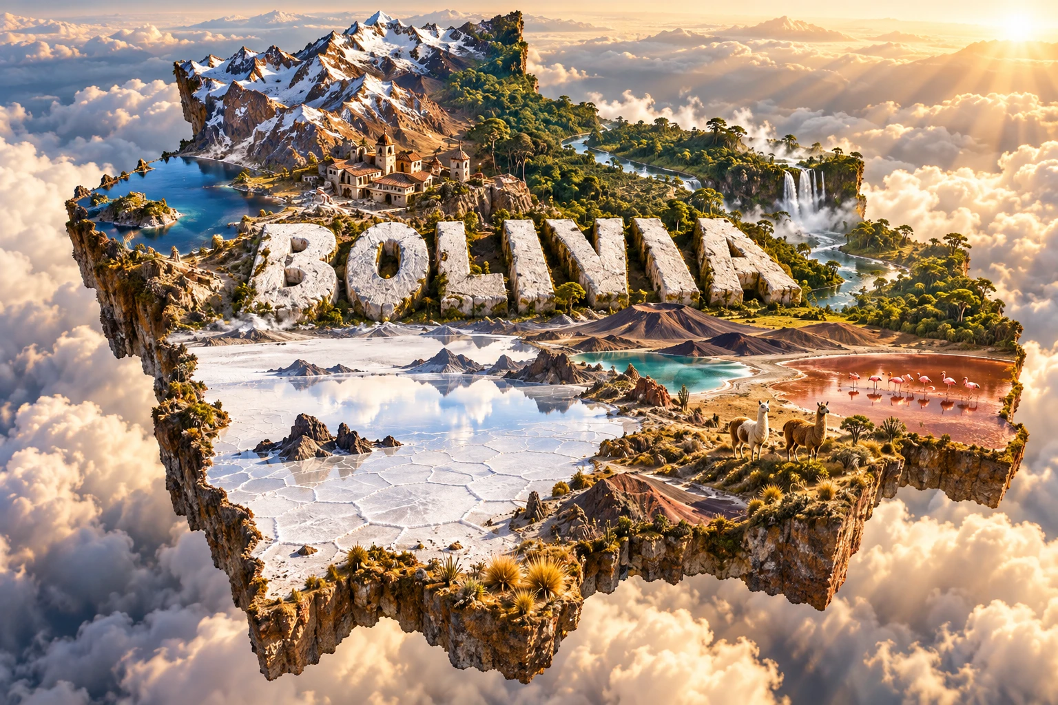
Bolivia is a landlocked South American country of extraordinary contrasts. Its west contains snowcapped Andes, the high Altiplano, Lake Titicaca and Salar de Uyuni, while most of its territory descends eastward through cloud forest into Amazonian lowlands, wetlands, savannas and the dry Gran Chaco.
This range is the key to understanding Bolivia. Mountain building created high enclosed basins, elevation controls climate and farming, and rivers on opposite sides of the Andes drain toward entirely different parts of the continent.
1. Where Is Bolivia?
Bolivia lies near the center of South America. Brazil borders it to the north and east, Paraguay to the southeast, Argentina to the south, and Chile and Peru to the west. Bolivia has been landlocked since losing its Pacific coast to Chile in the War of the Pacific in the late nineteenth century.
The constitution identifies Sucre as the capital. Sucre is also the seat of the Supreme Court of Justice. La Paz is the seat of the executive and legislative branches, so it is often described as Bolivia's administrative capital. Santa Cruz de la Sierra is the largest urban and economic center. Other important cities include El Alto, Cochabamba, Oruro, Potosí, Tarija, Trinidad and Cobija.
Bolivia occupies both the tropical lowlands east of the Andes and the high plateaus and ranges of the west. Although Andean scenery dominates international imagery, lowlands cover roughly three-fifths of the national territory.
2. Quick Country Facts
- Official name: Plurinational State of Bolivia
- Constitutional capital: Sucre
- Seat of government: La Paz
- Region: Central South America
- Area: 1,098,581 square kilometers
- Population: 11,365,333 people counted in the 2024 census
- Currency: Boliviano (BOB)
- Official languages: Spanish and 36 named Indigenous languages under the constitution; Quechua, Aymara and Guaraní are among the most widely used
- Time zone: Bolivia Time (UTC−4) throughout the year
- Highest point: Nevado Sajama, approximately 6,542 meters
- Major lake: Lake Titicaca, shared with Peru
- Major river systems: Amazon, Río de la Plata and the internally drained Altiplano basin
- Largest salt flat: Salar de Uyuni, the world's largest
The census total records people counted in 2024. Population projections and international modeled estimates may differ, so every total should be dated and sourced.
3. Geography and Landscape
Western Bolivia is framed by two Andean chains. The Cordillera Occidental follows the Chilean frontier and contains volcanoes, including Sajama. The Cordillera Oriental and its northern continuation, the Cordillera Real, include steep, glaciated peaks. Between them lies the Altiplano, a broad plateau generally more than 3,500 meters above sea level.
The northern Altiplano contains Lake Titicaca, whose waters moderate nearby temperatures and support wetlands, farms and settlements. Water leaves Titicaca through the Desaguadero River toward Lake Poopó and salt basins, but the system has no route to the ocean. Lake Poopó is shallow and has repeatedly contracted dramatically during drought and water stress.
Farther south, the plateau becomes colder and drier. Salar de Uyuni covers about 10,000 square kilometers with a remarkably level salt crust. Salar de Coipasa, colored lagoons, volcanic cones and geothermal fields form other parts of this high desert landscape.
East of the main divide, inter-Andean valleys around Cochabamba, Chuquisaca and Tarija have milder conditions and a long history of cultivation. The Yungas form a steep, humid transition where cloud forests descend toward the Amazon basin.
The northern departments of Pando and Beni contain Amazon forest, rivers, seasonally flooded savannas and wetlands. Santa Cruz includes Amazonian forest, Chiquitano dry forest, cerrado-like savanna and productive plains. The southeast enters the Gran Chaco, a hot, seasonally dry region of thorn forest and savanna shared with Paraguay and Argentina.
4. Why Does Bolivia Look Like This?
The Andes formed because the oceanic Nazca Plate is being forced beneath the South American Plate. Compression thickened and uplifted the crust, built volcanic arcs and raised the Altiplano. This process continues, producing earthquakes and volcanic activity across the central Andes.
The Altiplano developed between rising mountain chains. Many of its basins drain inward rather than reaching the sea. Water carries dissolved minerals down from volcanic and sedimentary rocks, then evaporates under the dry, windy climate. Over thousands of years, repeated lake expansion and contraction left salts concentrated in basins such as Uyuni.
Salar de Uyuni is a remnant of much larger prehistoric lakes. Its surface alternates seasonally: much of it is a hard white crust during dry conditions, while shallow rainy-season water can create a mirror effect. That mirror is temporary and does not cover the entire salar every day.
The eastern Andes intercept moisture arriving from the Amazon. Air forced upward cools and produces heavy rain on windward slopes, helping create Yungas cloud forest. Much less moisture crosses into the western plateau, producing a rain shadow. The southern Altiplano is especially arid.
Rivers descending eastward carry sediment into broad lowland plains. Seasonal rainfall and low gradients create floodplains, wetlands and shifting channels in Beni and the Amazon basin. In the southeast, greater distance from humid Amazonian influence and strong seasonality help produce the drier Chaco.
5. Climate
Bolivia lies within the tropics, but altitude produces major temperature differences. Northern lowlands are hot and humid for much of the year. Central and southeastern lowlands have clearer wet and dry seasons, while the Chaco can be extremely hot and seasonally dry.
Inter-Andean valleys are generally milder. The Altiplano has intense sunshine, cold nights, frequent frost and large daily temperature swings. High peaks remain cold enough for glaciers, although glacier area has declined as temperatures have risen.
Most of the country receives its greatest rainfall during the austral summer, broadly from November to March. Moist air from the Amazon feeds rain over eastern slopes and lowlands. Winter is usually drier, though regional patterns differ.
Cold southern air can occasionally surge far into the tropical lowlands, causing sudden temperature drops called surazos. These events show why latitude alone cannot explain Bolivia's weather.
Climate change compounds glacier loss, drought, wildfire, extreme rainfall and water insecurity. Exposure varies: highland cities depend partly on mountain water, lowland communities face floods and fires, and farms across the country respond to shifting rainfall and heat.
6. Wildlife and Ecosystems
Bolivia's habitats range from high Andean puna to Amazon rainforest. Animals in the artwork therefore belong to particular regions, not the whole country.
Llamas and alpacas are domesticated camelids raised mainly in the highlands. Wild vicuñas occupy puna grasslands and are managed for exceptionally fine fiber. Guanacos survive in more limited dry habitats. Andean condors range across mountain landscapes, while viscachas live among rocks.
Three flamingo species use high-altitude wetlands in southwestern Bolivia: Andean, James's and Chilean flamingos. Laguna Colorada and neighboring saline lakes provide feeding habitat, but water levels, food and bird numbers change seasonally. The critically endangered Lake Titicaca water frog is restricted to the Titicaca basin.
Yungas and Amazonian forests support jaguars, pumas, spectacled bears, tapirs, monkeys, macaws and immense plant and insect diversity. Species occupy different elevations and forest types. Jaguars also use some savanna and dry-forest landscapes where habitat remains connected.
The Beni savannas support marsh deer, giant anteaters, capybaras, river dolphins and waterbirds. The blue-throated macaw is native to a restricted area of northern Bolivia and remains threatened. Chiquitano dry forest and Gran Chaco wildlife must cope with stronger drought and seasonal heat.
Noel Kempff Mercado National Park protects an exceptional mosaic of Amazon forest, cerrado, wetlands, savanna and gallery forest around the Huanchaca Plateau. Major threats nationwide include agricultural conversion, wildfire, mining pollution, roads, illegal hunting and climate change.
7. Famous Landmarks and Natural Features
Salar de Uyuni is the world's largest salt flat. Its salt crust, polygon patterns, mineral-rich brines and occasional reflective water reveal the history of closed-basin lakes and intense evaporation.
Lake Titicaca, shared with Peru at about 3,810 meters, is one of the world's highest large navigable lakes. It supports totora wetlands, endemic wildlife and communities with deep cultural connections to the water.
Tiwanaku, near Titicaca, was the ceremonial and political center of a powerful pre-Columbian society. Monumental stonework and engineered drainage survive from a city that flourished especially between about AD 400 and 900. It should not be described simply as an Inca ruin; Tiwanaku preceded the Inca state.
The historic city of Sucre preserves a mixture of Indigenous, Spanish colonial and republican history. Independence was proclaimed in 1825 in the building now known as the Casa de la Libertad.
Potosí and Cerro Rico became a major center of silver mining under Spanish colonial rule. The wealth extracted there depended on coercive labor systems and caused enormous human suffering. Mining continues, and UNESCO lists the City of Potosí as World Heritage in Danger because of threats including instability in Cerro Rico.
Noel Kempff Mercado National Park protects more than 1.5 million hectares near the Brazilian border. Its forests, savannas, cliffs and waterfalls represent lowland Bolivia rather than the Andes.
Madidi National Park spans high Andes, cloud forest and Amazonian lowlands, producing extraordinary biodiversity across elevation zones.
8. People, Languages and Culture
Bolivia describes itself constitutionally as a plurinational state, recognizing Indigenous nations and peoples alongside intercultural and Afro-Bolivian communities. The 2024 census and other surveys record identity in specific ways; no single percentage captures the complexity of ancestry, language, place and self-identification.
Spanish is widely used, but the constitution also names 36 Indigenous languages as official. Quechua and Aymara have large speaker communities in the Andes, while Guaraní and numerous other languages are rooted in valleys and lowlands. Multilingualism varies by region and generation.
Tiwanaku societies shaped the highlands long before the Inca expanded into the region in the fifteenth century. Spanish conquest in the sixteenth century reorganized land, labor and religion around mining and colonial rule. Bolivia declared independence in 1825 and was named for Simón Bolívar.
Present-day traditions reflect Indigenous, European, African and mixed histories. The Oruro Carnival combines Catholic observance with Andean symbolism, music, masks and dance; UNESCO recognizes it as intangible cultural heritage. Different dance forms carry specific histories and should not be treated as one generic national costume.
Textile patterns and techniques vary among Aymara, Quechua and other communities. The bowler hat and layered pollera skirt are associated with many urban and highland Indigenous women, often called cholitas, but they do not represent every Bolivian woman or region.
Music includes regional forms using panpipes, drums, charango, brass bands and many other instruments. Lowland communities maintain distinct festivals, craft traditions, languages and musical styles that are often missing from Andes-centered portrayals.
9. Food
Bolivian food varies sharply with elevation and ecology. Highland staples include potatoes, chuño—potatoes preserved through repeated freezing and drying—quinoa, maize and meat from sheep or camelids. Chairo is a highland soup commonly made with chuño, vegetables and meat.
Salteñas are baked pastries filled with a juicy, seasoned mixture that may include meat, potatoes, peas and egg. Sopa de maní is a peanut-based soup with regional variations. Silpancho, associated with Cochabamba, combines rice, potatoes, breaded meat, egg and salad.
Lowland cooking uses cassava, rice, maize, plantain, fish and beef. Majadito, common around Santa Cruz, is a rice dish prepared in several forms. Lake and river fish matter locally, while fruit diversity expands in tropical areas.
Foods cross present-day borders and change by household. Calling one recipe universally Bolivian can obscure the country's strong regional identities.
10. Economy and Major Industries
Bolivia's economy has long depended on natural resources. Mining produces zinc, silver, tin, lead and gold, while natural gas has been a major export. Salar brines contain large lithium resources, but a resource estimate is not the same as commercially recoverable reserves or established production.
Agriculture ranges from small highland farms producing potatoes, quinoa and maize to large lowland operations growing soybeans, sugarcane, sunflower and other crops. Cattle ranching, Brazil-nut harvesting and forestry are important in parts of the east and north. Expansion can generate income while also driving deforestation and fire.
Manufacturing includes food processing, beverages, textiles, petroleum products and metal products. Trade, transport, government, finance and other services employ a large share of workers, many in the informal economy.
The World Bank's 2025 overview described Bolivia as a lower-middle-income economy with significant natural resources but weakening fiscal and external buffers after the commodity boom. Challenges include declining gas production, public debt, reserve pressure, poverty, informality, infrastructure gaps and exposure to climate hazards. Diversification and improved productivity matter because mineral and gas prices can change quickly.
11. What the 3D Visual Represents
The Bolivia artwork combines Salar de Uyuni, Andean peaks, Lake Titicaca, colored highland lagoons, Amazon rainforest, llamas, flamingos and Andean-inspired architecture. Monumental “BOLIVIA” lettering binds these separate regions into a floating miniature landscape.
The elements are geographically distant. Uyuni lies in the southwestern Altiplano; Titicaca is in the northwest; humid Amazon forest spreads mainly across the north and east. Flamingos concentrate around suitable high-altitude wetlands, and llamas are associated primarily with Andean regions. Neither occurs uniformly across Bolivia.
The image is a conceptual artistic composition. The landmarks, wildlife and landscapes are combined for educational visualization and are not shown at their true geographic positions or scale. It is not a satellite map, ecological range map or photograph of one location.
12. Interesting Facts About Bolivia
- Bolivia has no seacoast but belongs to three major drainage regions.
- Sucre is the constitutional capital, while La Paz is the seat of government.
- Lowlands cover more of Bolivia than the Andes-focused imagery suggests.
- Nevado Sajama is the country's highest mountain and an extinct volcano.
- Lake Titicaca is shared with Peru at roughly 3,810 meters above sea level.
- Salar de Uyuni is the world's largest salt flat.
- Uyuni's famous mirror appears only when shallow water covers the salt surface.
- The Altiplano contains basins whose water never reaches the ocean.
- Tiwanaku flourished centuries before the Inca Empire.
- Bolivia's constitution recognizes Spanish and 36 Indigenous languages as official.
- The 2024 census counted 11,365,333 residents.
- All three South American flamingo species occur in Bolivia's high Andean wetlands.
- Noel Kempff Mercado National Park includes both Amazon forest and savanna.
- Potosí's colonial silver wealth was built through coercive and dangerous labor.
- Bolivia is named after independence leader Simón Bolívar.
13. Short Quiz
-
Which city is Bolivia's constitutional capital? A. La Paz B. Santa Cruz C. Sucre D. Potosí
-
Why did salt accumulate at Salar de Uyuni? A. Ocean tides deposited it B. Water evaporated from a closed basin C. A glacier imported seawater D. Coral reefs dissolved
-
Which environment covers much of northern and eastern Bolivia? A. Amazonian lowlands B. Mediterranean coast C. Arctic tundra D. Ocean islands
-
Which civilization built the monumental center at Tiwanaku? A. Roman B. Tiwanaku C. Aztec D. Maya
-
How should the 3D visual be interpreted? A. As an exact satellite map B. As one real landscape C. As a conceptual combination of distant features D. As a wildlife census
Answer key: 1-C, 2-B, 3-A, 4-B, 5-C.
14. Related Learning
Suggested internal-link topics:
- Peru Explained: Andes, Amazon, Coast and Ancient Civilizations
- Chile Explained: Andes, Atacama, Coast and Earthquakes
- Brazil Explained: Amazon, Highlands, Wetlands and Culture
- Argentina Explained: Andes, Pampas, Patagonia and Culture
- Paraguay Explained: Rivers, Chaco and Guaraní Culture
- How the Andes Created Bolivia's Altiplano
- Why Salar de Uyuni Is the World's Largest Salt Flat
- How Lake Titicaca Supports Life at High Altitude
- Why the Yungas Are Wet but the Altiplano Is Dry
- How Silver Mining Transformed Potosí
15. Sources
- Bolivia National Institute of Statistics — 2024 Census results
- Bolivia National Institute of Statistics — Population and vital statistics
- Constitution of Bolivia — official languages and capital
- World Bank — Bolivia overview
- World Bank Data — Bolivia
- FAO — Bolivia geography and agricultural regions
- NASA Earth Observatory — A Salt Bath in Bolivia
- Convention on Wetlands — Lake Titicaca
- UNESCO World Heritage Centre — Bolivia
- UNESCO — Tiwanaku
- UNESCO — Noel Kempff Mercado National Park
- UNESCO Intangible Cultural Heritage — Carnival of Oruro
- Encyclopaedia Britannica — Bolivia