

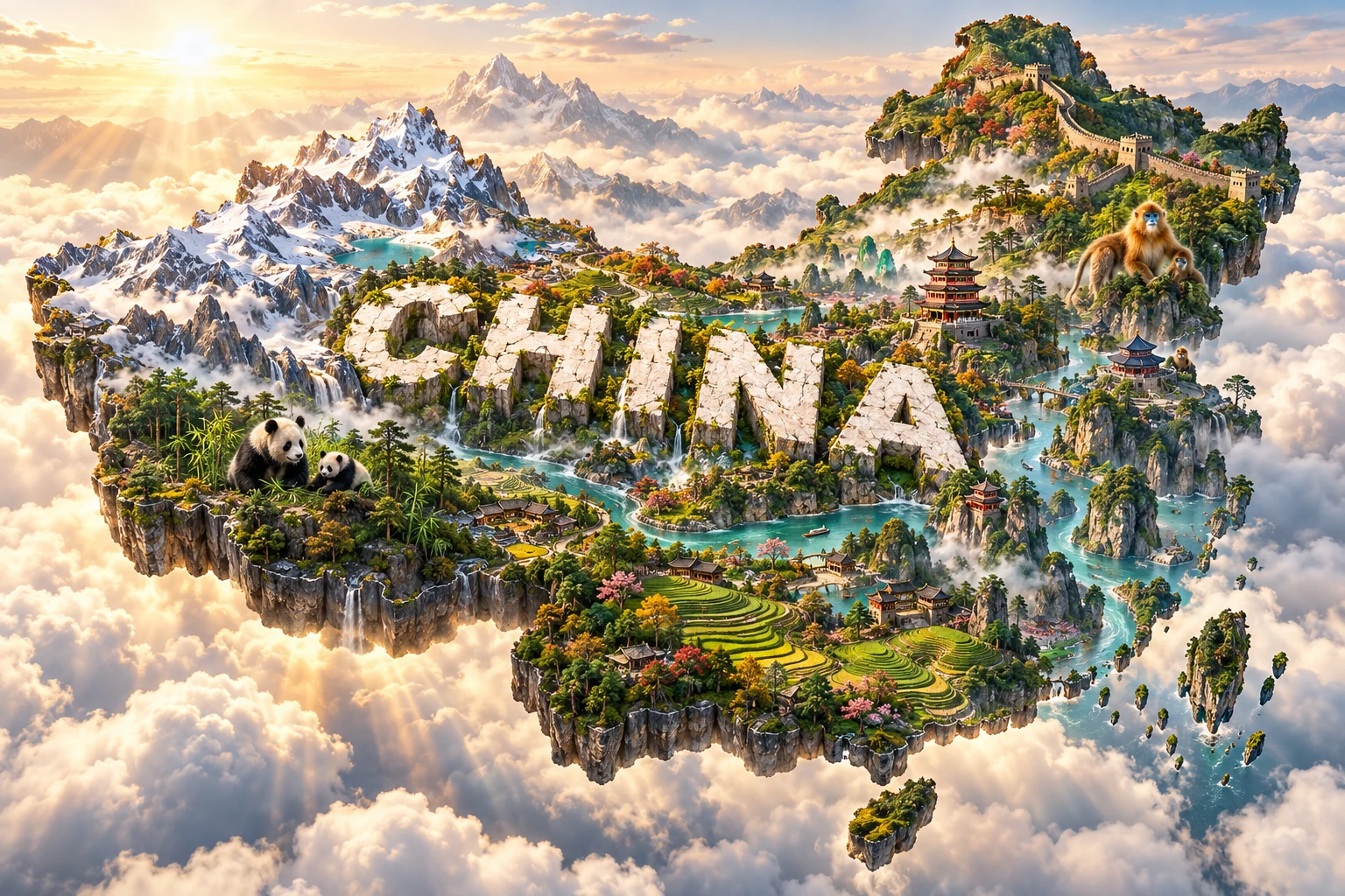
China's landscapes descend in broad steps from the Tibetan Plateau and high mountains of the west toward river plains and the Pacific coast in the east. This pattern shapes the country's climate, waterways, farming, ecosystems and settlement. It helps explain why western China is generally higher, colder and more sparsely populated, while many of the largest cities and most intensively farmed areas lie farther east.
Glaciers, deserts, grasslands, forests, subtropical karst, tropical islands, river basins and crowded coastal deltas all occur within China. Its cultural geography is equally varied, with many languages, cuisines and communities.
1. Where Is China?
China lies in East Asia on the western side of the Pacific Ocean. Its mainland coast faces the Bohai Sea, Yellow Sea, East China Sea and South China Sea. It shares land borders with 14 countries: North Korea, Russia, Mongolia, Kazakhstan, Kyrgyzstan, Tajikistan, Afghanistan, Pakistan, India, Nepal, Bhutan, Myanmar, Laos and Vietnam. Some borders and maritime claims are disputed.
The People's Republic of China administers mainland China, Hong Kong and Macao. It claims Taiwan, which is governed separately. This article describes physical and human geography without treating a stylized artwork as evidence about territorial claims.
Beijing is the capital. Shanghai, on the Yangtze estuary, is a major commercial center, while Guangzhou and Shenzhen anchor part of the Pearl River Delta. Chongqing occupies an important upper-Yangtze position, and cities such as Chengdu, Wuhan, Xi'an, Nanjing, Tianjin and Harbin developed within distinct regional landscapes.
2. Quick Country Facts
- Official name: People's Republic of China
- Capital: Beijing
- Region: East Asia
- Land area: Approximately 9.6 million square kilometers
- Population: About 1.405 billion at the end of 2025 for mainland statistical coverage, excluding Hong Kong, Macao and Taiwan
- Currency: Renminbi; the yuan is its principal unit (CNY)
- Official language: Standard Chinese, commonly called Mandarin or Putonghua
- Other languages: Numerous Sinitic varieties and minority languages, including Tibetan, Mongolian, Uyghur, Zhuang, Korean and others
- Time zone: China Standard Time, UTC+8
- Highest point: Mount Everest, or Qomolangma, 8,848.86 meters, on the China-Nepal border
- Longest river: Yangtze, or Chang Jiang
- Other major rivers: Yellow, Pearl, Heilong/Amur, Songhua, Lancang/Mekong, Yarlung Tsangpo/Brahmaputra and Tarim
China uses one official time zone despite spanning a geographical width that would ordinarily cover several. Population figures require a stated statistical scope because official mainland totals do not include every territory claimed or administered by the state.
3. Geography and Landscape
China's terrain is often described as a staircase descending from west to east. The highest step includes the Tibetan Plateau, with an average elevation of roughly 4,500 meters, and mountain systems such as the Himalaya, Karakoram, Kunlun and Pamir. Glaciers and snowfields in this wider region feed rivers that flow across much of Asia.
Farther north and east lie large interior basins and uplands. The Tarim Basin contains the Taklamakan Desert, surrounded by high mountains. The Junggar Basin lies farther north, and the Gobi's stony deserts and dry steppe extend across northern China and Mongolia. The Loess Plateau is mantled by fine, windblown sediment that erodes easily when vegetation is disturbed.
Eastern China contains broad plains and lower hills. The Northeast China Plain, North China Plain and middle and lower Yangtze lowlands support major cities and intensive agriculture. The Yangtze basin links the interior to the coast, while the Yellow River crosses the Loess Plateau and carries an unusually heavy sediment load. Its shifting channel and floods have profoundly influenced northern history.
Southern and southwestern China are more rugged. Limestone landscapes around Guangxi, Guizhou, Yunnan and Chongqing contain towers, sinkholes, caves and underground drainage. Rice terraces reshape mountain slopes where communities have managed soil and water for generations. Sichuan is a large basin surrounded by mountains, and Yunnan spans deep valleys and strong elevation changes.
The coastline includes bays, estuaries, mudflats and rocky shores. The Yangtze and Pearl deltas are densely urbanized. Hainan Island has tropical landscapes, while smaller islands vary in geology and ecology.
4. Why Does China Look Like This?
Plate tectonics built much of western China's relief. For around 50 million years, the Indian Plate has converged with Eurasia. Compression thickened and uplifted the crust, creating the Himalaya and raising the Tibetan Plateau. The collision remains active, producing earthquakes and landslides as well as continued deformation.
High terrain then affects the atmosphere. The plateau and surrounding mountains influence Asian circulation, redirect moisture and create strong rain shadows. Mountain glaciers and seasonal snow store water, while elevation produces ecological zones ranging from valley forest to alpine meadow and permanent ice.
Desert landscapes formed where moisture is limited by distance from oceans, surrounding mountains and atmospheric circulation. Sediment from dry regions was repeatedly lifted by wind and deposited farther east, helping form the thick loess layers of north-central China. Rivers cut steep gullies into this soft material and transport its sediment downstream.
South China's karst developed through a different process. Slightly acidic rain and groundwater dissolved thick carbonate rocks over immense periods. Fractures widened into caves and underground channels, while less soluble rock remained as steep towers and ridges. “Karst” therefore refers to a process and landform system, not simply picturesque pointed hills.
Rivers have continually rebuilt the east. The Yellow River deposited sediment, raised its bed in places and changed course many times. The Yangtze and Pearl systems constructed lowland floodplains and deltas. Dams, levees, canals, cities and land reclamation now modify these processes, but floods, erosion and sediment movement still shape the landscape.
5. Climate
China spans tropical, subtropical, temperate and high-altitude climates. Winters are generally colder and drier toward the north and interior. Southern areas are warmer and often more humid, while the Tibetan Plateau is cold because of elevation rather than latitude alone.
The East Asian monsoon supplies much of eastern China's warm-season rain. Moist summer air moves inland from the Pacific and Indian Ocean regions, but rainfall generally decreases toward the northwest. Southeastern coasts and mountains can receive heavy rain, whereas Xinjiang and parts of the Tibetan Plateau are arid or semi-arid.
Winter high pressure over the Asian continent sends cold, dry air southward. Northern cities may experience severe cold, while southern winters are milder. Typhoons can bring destructive winds, storm surge and extreme rainfall to the southeast and east coasts. Floods affect major river basins; drought, heat waves, dust storms, cold events and landslides create other regional hazards.
Climate change is raising average temperatures, intensifying heat risk and affecting glaciers, permafrost, rainfall extremes, coasts and ecosystems. Because China is so large, changes do not appear identically everywhere. Water availability may depend on both long-term climate trends and local management, irrigation, reservoirs and demand.
6. Wildlife and Ecosystems
China's ecosystems range from boreal forest and steppe in the northeast to alpine habitats in the west, temperate forest in central mountains, deserts in the northwest, subtropical forest in the south and mangroves and coral communities along warmer coasts.
Wild giant pandas do not live across China. They survive in fragmented temperate mountain forests with bamboo in Sichuan, Shaanxi and Gansu. The Sichuan Giant Panda Sanctuaries protect a major connected area of panda habitat as well as red pandas, snow leopards, clouded leopards and rich plant diversity. Habitat connectivity matters because isolated populations are more vulnerable.
Golden snub-nosed monkeys inhabit cool mountain forests in separated parts of central and southwestern China. Several species in the snub-nosed monkey group have different ranges. The golden species shown in the artwork should therefore represent particular highland forests, not the whole country.
The Tibetan Plateau supports animals adapted to cold, open terrain, including Tibetan antelope, wild yak and kiang. Northeast forests retain Amur tigers and leopards in limited transboundary habitats. The Yangtze basin supports the critically endangered Yangtze finless porpoise, while the Chinese alligator survives in restricted lower-Yangtze wetlands and managed conservation areas.
Protected areas include national parks, nature reserves, wetland sites and UNESCO properties. Important pressures include habitat fragmentation, infrastructure, pollution, overuse of water, invasive species, illegal wildlife trade and climate change. Restoration and species-recovery programs have helped some populations, but conservation status varies greatly by species and region.
7. Famous Landmarks and Natural Features
The Great Wall is not one continuous wall built at one time. It is a vast system of walls, trenches, passes, towers and fortifications created and rebuilt by different states and dynasties. Many famous masonry sections near Beijing date mainly from the Ming period, while older remains can be earthen and less visible. Its purpose involved defense, communication and control of movement.
Beijing's Forbidden City was the imperial palace complex of the Ming and Qing dynasties. Its courtyards, halls and axial plan express political hierarchy and ritual ideas. Today it houses the Palace Museum and preserves architecture, objects and landscapes from several centuries.
The Terracotta Army near Xi'an belongs to the mausoleum complex of Qin Shi Huang, the first emperor to unify China under the Qin dynasty. Thousands of clay soldiers, horses and chariots were made for the funerary complex, with individual details that provide evidence about craftsmanship and military organization.
The South China Karst World Heritage property includes separate areas with tower karst, stone forests, caves and other limestone landforms. Guilin's scenery is closely associated with karst around the Li River, but southern karst extends far beyond one city.
The Yangtze River is China's longest river and a central transport, agricultural, cultural and ecological corridor. It flows from high western terrain through central China to the East China Sea. The Three Gorges Dam produces electricity and supports flood-control and navigation goals, while also transforming habitats, sediment movement and communities.
The Yellow River is often linked to the development of early states in northern China. Loess-derived sediment gives the river its color and contributed both fertile deposits and catastrophic channel changes. It is one of several regional centers of Chinese history, not the country's only cultural origin.
8. People, Languages and Culture
China officially recognizes 56 ethnic groups, of which Han Chinese form the large majority. This classification does not erase internal diversity: regional history, language, migration, urbanization and local identity create many different experiences. Minority communities include Zhuang, Hui, Manchu, Uyghur, Miao, Yi, Tujia, Tibetan, Mongol and many others.
Standard Chinese is the national common language and is based largely on the Beijing pronunciation of Mandarin. Spoken Chinese also includes Mandarin varieties and other Sinitic language groups such as Cantonese/Yue, Wu, Min, Hakka and Xiang; these are not always mutually intelligible. Minority languages belong to several language families and may use distinct writing systems.
Chinese writing helped connect speakers across regions, but it has changed over time. Simplified characters are standard in mainland China, while traditional characters remain common in Hong Kong, Macao and Taiwan and in some overseas communities. Calligraphy is both writing and a major art form.
Cultural traditions include regional opera, instrumental music, poetry, painting, ceramics, woodwork, textile arts, martial practices and many forms of popular media. Architecture ranges from courtyard houses and timber halls to earthen tulou, cave dwellings, Tibetan buildings, Islamic mosques and modern high-rises.
Lunar New Year is widely celebrated, but customs and foods differ by region and community. Other observances include the Lantern, Qingming, Dragon Boat and Mid-Autumn festivals, alongside religious and ethnic festivals with more localized significance. Modern life blends inherited customs with mass education, migration, digital technology and global exchange.
China's recorded past includes early Bronze Age states, imperial unification under the Qin in 221 BCE and long periods of rule by dynasties such as the Han, Tang, Song, Yuan, Ming and Qing. The imperial system ended in 1911–12. After decades of conflict, invasion and civil war, the People's Republic of China was established in 1949. Economic reforms beginning in the late 1970s drove rapid industrialization and urbanization.
9. Food
Chinese food is a collection of regional traditions rather than one cuisine. Wheat noodles, dumplings and steamed breads are especially important in many northern areas, while rice is prominent across much of the south. Millet, maize, potatoes, soybeans, vegetables, pork, poultry, fish and seafood have regional roles shaped by climate, agriculture and trade.
Sichuan cuisines are known for complex combinations that may include chilies and the numbing sensation of Sichuan pepper. Cantonese traditions often emphasize freshness and varied techniques; Jiangnan cooking reflects the lower Yangtze's waterways and produce; northern cuisines make extensive use of wheat. Halal foods are important among Hui and other Muslim communities, while Tibetan Plateau diets reflect high elevation and pastoralism. Tea culture also differs by region, processing style and occasion.
10. Economy and Major Industries
China is a major manufacturing and trading economy. Industries include electronics, machinery, vehicles, steel, chemicals, textiles, appliances, shipbuilding and consumer goods. Extensive ports, railways, highways and logistics networks connect industrial regions to domestic and global markets.
Services have expanded through retail, finance, transport, telecommunications, software, education, health and digital platforms. Agriculture remains important despite its smaller share of economic output. China produces large quantities of rice, wheat, maize, vegetables, fruit, pork, tea and aquaculture products, but farm systems and water conditions differ sharply by region.
China is the world's largest user of coal and a major greenhouse-gas emitter, while also deploying solar, wind, hydropower, nuclear power and electric vehicles at enormous scale. This combination makes its energy transition globally significant.
Rapid growth since the late 1970s reduced extreme poverty and built major infrastructure, but also brought air, soil and water pollution, habitat loss, high resource demand and regional inequality. Current challenges include an aging and declining population, property-sector stress, local debt, uneven household consumption and shifting global trade conditions.
11. What the 3D Visual Represents
The China artwork combines sections of the Great Wall, southern karst mountains, Himalayan peaks, rice terraces, Yangtze-like waterways, classical pagodas, giant pandas and golden snub-nosed monkeys. Monumental “CHINA” lettering and a floating landform turn these themes into a compact educational micro-world.
The elements refer to different regions and periods. The Himalaya lies along the southwestern frontier, major karst landscapes occur mainly in the south and southwest, and wild giant pandas occupy limited mountain forests in central China. Rice terraces occur in several southern and southwestern regions, while Great Wall systems extend across parts of northern China. Pagodas also vary greatly in date, purpose and architectural form.
The image is a conceptual artistic composition. The landmarks, wildlife and landscapes are combined for educational visualization and are not shown at their true geographic positions or scale. Its stylized outline is not evidence for interpreting disputed land or maritime claims.
12. Interesting Facts About China
- China's terrain generally descends from very high plateaus and mountains in the west toward eastern lowlands and seas.
- The Tibetan Plateau was raised through the continuing collision of the Indian and Eurasian plates.
- China borders 14 countries by land, tying the global record for the most land neighbors.
- One official time zone, UTC+8, is used across a country wide enough for several geographical time zones.
- The Yangtze is China's longest river and drains a basin that supports major cities, farms and ecosystems.
- Fine windblown sediment called loess covers large areas of north-central China and erodes easily.
- The Yellow River's huge sediment load has repeatedly altered its channel and floodplain.
- South China's tower karst formed as water dissolved carbonate rock along fractures over long periods.
- The Great Wall is a network of fortifications from different eras, not a single uniform structure.
- Wild giant pandas live only in fragmented mountain ranges in Sichuan, Shaanxi and Gansu.
- Mount Everest, or Qomolangma, stands on the China-Nepal border.
- The Taklamakan is a major desert enclosed by mountain systems within the Tarim Basin.
- Spoken Chinese includes language groups and varieties that are not all mutually intelligible.
- The Grand Canal links river systems across eastern China and developed over many historical periods.
- The Yangtze finless porpoise is the river system's only surviving cetacean after the baiji was declared functionally extinct.
13. Short Quiz
-
Why are the Himalaya and Tibetan Plateau so high? A. Coral growth B. Collision of the Indian and Eurasian plates C. River deposition alone D. A recent meteorite impact
-
Which is China's longest river? A. Yellow River B. Pearl River C. Yangtze River D. Tarim River
-
What creates South China's karst landscapes? A. Dissolution of carbonate rock by water B. Glacial ice only C. Coral reefs rising inland D. Wind depositing loess
-
Where do wild giant pandas live? A. Throughout China B. Only on tropical beaches C. In limited central Chinese mountain forests D. Across the Gobi Desert
-
What does the Great Wall consist of? A. One unbroken wall built in one year B. Fortifications built and rebuilt in different eras C. A natural mountain ridge D. A modern national border fence
Answer key: 1-B, 2-C, 3-A, 4-C, 5-B.
14. Related Learning
Suggested internal-link topics:
- Mongolia Explained: Steppe, Desert and Nomadic Heritage
- India Explained: Plate Tectonics, Monsoons and the Himalaya
- Nepal Explained: Mountains, Rivers and High-Altitude Ecosystems
- Vietnam Explained: Deltas, Monsoons and Regional Culture
- Why Is the Tibetan Plateau So High?
- How the Yangtze River Shapes China
- Why Does the Yellow River Carry So Much Sediment?
- How South China's Karst Towers Formed
- Where Wild Giant Pandas Live and Why
- How the East Asian Monsoon Works
15. Sources
- National Bureau of Statistics of China — 2025 national economic and social development communiqué
- State Council Information Office — China geography facts
- Ministry of Commerce of China — 2025 country overview
- NASA Earth Observatory — Tibetan Plateau and ongoing plate collision
- UNESCO World Heritage Centre — China
- UNESCO World Heritage Centre — Great Wall
- UNESCO World Heritage Centre — South China Karst
- UNESCO World Heritage Centre — Sichuan Giant Panda Sanctuaries
- IUCN Red List — giant panda species information
- World Bank — China overview