

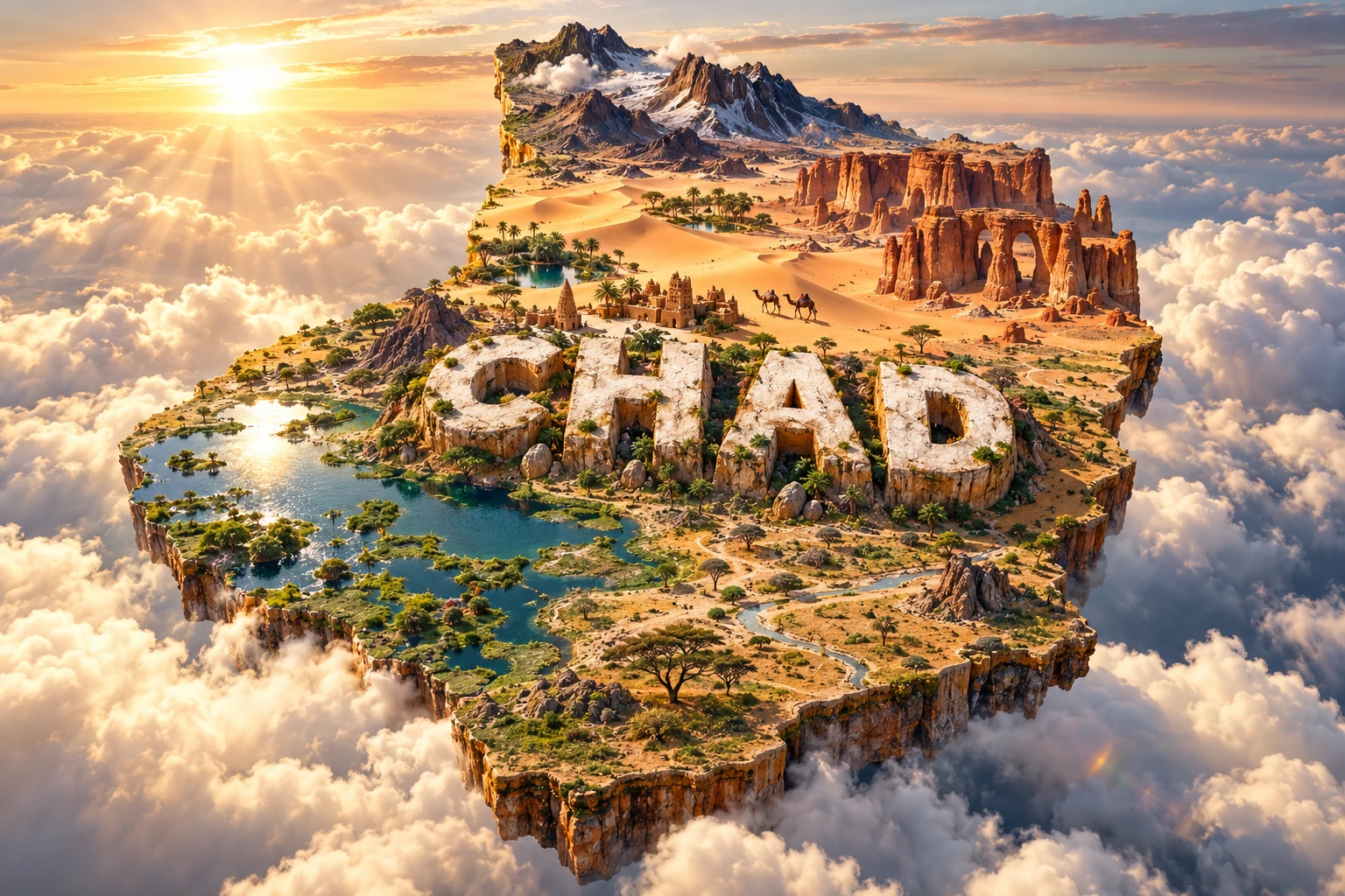
Chad stretches across three major African environmental zones. The Sahara dominates the north, the Sahel forms a broad semi-arid center, and wetter savanna and seasonal wetlands occur in the south. At the country's western edge, the Chari and Logone rivers feed shallow Lake Chad, whose size changes dramatically with seasons and longer climatic cycles.
This north–south contrast shapes settlement, farming, herding, wildlife and transport. Chad also contains the volcanic Tibesti Mountains, the sandstone canyons of Ennedi and a chain of permanent desert lakes at Ounianga—evidence that today's hyperarid Sahara once experienced very different climates.
1. Where Is Chad?
Chad is a landlocked country in north-central Africa. Libya borders it to the north, Sudan to the east, the Central African Republic to the south, Cameroon and Nigeria to the southwest, and Niger to the west. Its territory links North, West and Central Africa.
The capital, N'Djamena, stands in the southwest near the meeting of the Chari and Logone rivers and the border with Cameroon. Other important cities and towns include Moundou, Sarh, Abéché, Kélo, Koumra, Faya-Largeau and Mongo.
Chad has no direct access to a seaport. Most overseas trade must travel long distances through neighboring countries, particularly toward Cameroon's Atlantic ports. Poor roads, seasonal flooding and insecurity increase transport costs within this very large country.
2. Quick Country Facts
- Official name: Republic of Chad
- Capital: N'Djamena
- Region: North-central Africa; spanning Sahara, Sahel and Sudanian zones
- Area: Approximately 1,284,000 square kilometers
- Population: Approximately 21.0 million in the World Bank's 2025 estimate
- Currency: Central African CFA franc (XAF)
- Official languages: Arabic and French
- Widely spoken languages: Chadian Arabic and many African languages
- Time zone: West Africa Time (UTC+1) throughout the year
- Highest point: Emi Koussi, approximately 3,415 meters
- Major rivers: Chari and Logone
- Major lake: Lake Chad, shared within an international basin
- Geographic condition: Landlocked
Population estimates are affected by rapid growth, displacement and data limitations. Lake area figures also depend heavily on season, rainfall and what researchers count as open water, marsh or flooded vegetation.
3. Geography and Landscape
Northern Chad lies deep within the Sahara. It includes gravel plains, sand seas, dry valleys and isolated massifs rather than endless dunes alone. The Tibesti Mountains rise in the far north, with volcanic cones, calderas, lava fields and hot springs. Emi Koussi is the Sahara's highest summit.
East of the Tibesti, the Ennedi Massif is a sandstone plateau cut into cliffs, canyons, pillars and natural arches. Permanent or long-lasting water in some guelta pools supports people, livestock and wildlife in an otherwise arid region. Thousands of rock paintings and engravings record changing environments and human life over millennia.
The central Sahel receives more rain than the Sahara but remains vulnerable to drought. Grassland, thorn scrub and seasonal streams support farming and pastoralism where conditions allow. Lake Fitri is an important inland wetland whose size varies with inflow and evaporation.
Southern Chad contains wooded savanna, cropland and major floodplains. The Chari and Logone collect much of their water from wetter areas farther south, then flow toward N'Djamena and Lake Chad. Around Zakouma, rivers and rain create seasonal wetlands that concentrate wildlife during the dry season.
Lake Chad is extremely shallow and has islands, reed beds, mudflats, channels and open-water pools whose arrangement changes. Chad shares the basin with Cameroon, Niger, Nigeria and the Central African Republic, although the present lake itself chiefly touches Chad, Cameroon, Niger and Nigeria depending on water extent.
4. Why Does Chad Look Like This?
Chad occupies the broad Chad Basin, a low interior depression surrounded by uplands. Rivers and winds have carried sediment into the basin for millions of years. Because it has no outlet to the sea, water ends in lakes, wetlands, soils or the atmosphere through evaporation.
Lake Chad is the surviving remnant of much larger “Mega-Chad” lakes that expanded during wetter periods. Rainfall across the Chari–Logone catchment is the lake's main water control. When rainfall and river inflow fall, its shallow water retreats quickly; when inflow rises, flooded area expands. Irrigation, population pressure and warming also affect the system, but climate variability has been a major driver.
Comparisons that show a more than 90 percent decline usually contrast the unusually wet 1960s with severe drought decades and often measure open water. They teach something real about contraction, but can hide seasonal recovery, marsh vegetation and separate northern and southern pools. Lake Chad has not changed at a single steady rate.
The Tibesti is volcanic. Magma rose through old continental crust and built huge shield volcanoes, calderas and lava fields. Emi Koussi has not erupted in recorded history, but fumaroles and geothermal features reveal the region's volcanic origin.
Ennedi's sandstone was fractured, then sculpted by past rivers, rainfall, temperature changes, wind and blowing sand. Natural arches form where weathering exploits weaker layers and joints. Rock art showing cattle and wildlife also provides evidence of earlier, wetter Saharan environments.
5. Climate
Rainfall increases strongly from north to south. The northern Sahara is hyperarid: some places may receive almost no rain in a year, while temperatures can vary sharply between day and night. Dust storms and dry winds are common.
The Sahel has a short, irregular rainy season, generally during the northern summer. Year-to-year changes in the West African monsoon can mean useful pasture and crops in one year but drought or destructive downpours in another.
The south receives a longer rainy season and supports rain-fed agriculture and woodland. Heavy rain swells the Chari, Logone and southeastern floodplains. Floodwater is ecologically valuable but can displace people, damage crops and interrupt roads.
Climate change is increasing extreme heat and adding stress to water, crops and livestock. Drought, intense rain and flooding can alternate. Desertification is not simply a wall of dunes moving south; it describes land degradation produced by interacting climate, vegetation, soil and land-use pressures.
6. Wildlife and Ecosystems
Chad's wildlife varies sharply by region. Desert-adapted species in the north include dorcas gazelles, Barbary sheep and smaller mammals, reptiles and birds. Many populations are sparse and threatened, so a desert animal should not be assumed to occur across every northern landscape.
The Ennedi landscape retains relict populations associated with isolated water and rugged terrain. The famous crocodiles of Guelta d'Archei are an isolated desert population whose survival depends on scarce permanent water. The pool is also used by camels and local communities, creating a tightly shared system.
Zakouma National Park in southeastern Chad protects savanna, floodplain, woodland and perennial water. It supports elephants, Kordofan giraffes, buffalo, tiang, hartebeest, lions and many waterbirds. After catastrophic elephant poaching, stronger protection and community programs helped the population recover; African Parks reported about 800 elephants in its current overview. That success is regional, not evidence that elephants are widespread nationally.
Lake Chad and the Chari–Logone wetlands support fish, waterbirds, livestock and flood-recession farming. Fish abundance changes with flood extent and access to breeding habitat. The endangered Kuri cattle breed is closely associated with the lake environment.
Threats include poaching, habitat conversion, livestock pressure, wetland change, conflict and climate extremes. Conservation is strongest when it incorporates migration corridors, pastoral access, fisheries and the needs and knowledge of nearby communities.
7. Famous Landmarks and Natural Features
Ennedi Massif is a mixed UNESCO World Heritage property recognized for both natural formations and cultural evidence. Wind and water shaped its sandstone canyons and arches, while thousands of painted and engraved images document long human relationships with the Sahara.
Lakes of Ounianga comprise 18 lakes in two groups within a hyperarid desert receiving less than two millimeters of rain annually. Groundwater replaces much of the water lost to evaporation. Different salinity, microorganisms and vegetation help produce varied colors.
Tibesti Mountains form Chad's highest and most rugged terrain. Emi Koussi rises within this volcanic massif, and remote settlements and oases depend on localized water.
Lake Chad is an international wetland rather than a conventional deep lake. Its floating vegetation, islands and shifting channels support communities whose livelihoods combine fishing, farming, herding and trade.
Zakouma National Park is important for savanna conservation, seasonal wildlife movement and wetlands used by resident and migratory birds. Its recent recovery followed intense earlier poaching losses.
Guelta d'Archei is a water-filled canyon in Ennedi used by camel caravans and a small crocodile population. Images of it can create the impression of a pristine empty wilderness, but it is a working cultural and pastoral landscape.
8. People, Languages and Culture
Chad is highly diverse, with well over 100 languages spoken. Arabic and French are official. Chadian Arabic functions as an important shared language, but its use and first-language status vary. Sara languages are prominent in the south, while Kanembu, Tebu languages, Maba, Masalit, Fulfulde and many others have regional importance.
Communities include Sara peoples in the south; Arab communities in several regions; Kanembu around the Lake Chad area; Tebu peoples in northern and central zones; Maba and related communities in the east; Fulani pastoralists; and many others. These categories overlap and contain substantial internal diversity.
Islam is practiced by a majority and is especially prominent in northern, central and eastern regions. Christianity has large communities, particularly in the south, and Indigenous religious traditions remain important. Religious geography is not absolute, and families and cities may be mixed.
Long before modern borders, the Lake Chad region supported the Kanem and later Kanem-Bornu states, while Wadai became powerful in the east. Trans-Saharan and regional trade moved salt, livestock, textiles and other goods, but also involved enslavement.
France incorporated the territory into French Equatorial Africa after military conquest. Chad became independent in 1960. Later history includes civil wars, authoritarian government, regional intervention and recurring insecurity. These conditions have affected movement, education and cultural institutions but do not define every aspect of daily life.
Poetry, oral history, music, dance, leatherwork, weaving, metalwork and decorated architecture differ by community and environment. Camel culture belongs mainly to arid and pastoral regions; it is not a universal national lifestyle.
9. Food
Staples change with rainfall. Boule, a firm porridge or ball made from millet, sorghum, maize or another grain, is commonly eaten with vegetable, meat or fish sauces. The grain and sauce vary by household and region.
Daraba is a sauce or stew associated particularly with southern Chad and may include okra, greens, tomatoes and groundnuts. Kisra, a thin fermented sorghum flatbread shared across the region, is more common in eastern and Arabic-influenced food traditions.
Fish is important around Lake Chad and the Chari–Logone system and may be fresh, smoked or dried. Dates occur in Saharan oases. Milk and meat matter in pastoral communities, while groundnuts, sesame, okra and leafy vegetables contribute to many meals.
Food availability is affected by rain, floods, displacement, transport and market prices. National dishes should therefore be presented as varied traditions rather than one fixed menu.
10. Economy and Major Industries
Oil has dominated Chad's formal exports and public revenue since production expanded in the early 2000s. This creates vulnerability to price changes, production declines and decisions about how revenue is managed.
Agriculture and livestock support much of the population. Farmers grow sorghum, millet, maize, groundnuts, sesame, cotton and other crops in suitable zones. Cattle, camels, goats and sheep move through pastoral and agropastoral systems adapted to seasonal water and pasture.
Gum arabic from acacia trees is an important non-oil product. Fishing and fish processing matter in the Lake Chad and river regions. Small-scale trade, transport, construction, telecommunications and public services provide additional work, much of it informal.
The World Bank estimated Chad's economy grew 5.6 percent in 2025, with oil, mining and agriculture contributing, though estimates differ by publication and may be revised. Poverty, food insecurity, limited electricity, poor roads, debt exposure and regional conflict constrain broader gains.
11. What the 3D Visual Represents
The Chad artwork combines Lake Chad, Sahara dunes, Ennedi sandstone arches and canyons, the volcanic Tibesti Mountains, desert oases, camels and Sahelian-inspired architecture. Embedded “CHAD” lettering compresses these distant features into one floating micro-world.
The real locations are widely separated. Lake Chad lies at the western edge; Tibesti rises in the far north; Ennedi occupies the northeast; and wetter savanna lies in the south and southeast. Camels are especially associated with northern and central pastoral and trading landscapes, not every region.
The image is a conceptual artistic composition. The landmarks, wildlife and landscapes are combined for educational visualization and are not shown at their true geographic positions or scale. Lake Chad's depicted shoreline should not be read as a current scientific map.
12. Interesting Facts About Chad
- Chad is Africa's fifth-largest country by area.
- It spans the Sahara, Sahel and wetter Sudanian savanna.
- Emi Koussi is a 3,415-meter volcanic mountain and the Sahara's highest summit.
- Lake Chad is shallow, seasonal and divided among open water, channels and marsh.
- Most Lake Chad inflow comes from the Chari–Logone system.
- Ancient Mega-Chad was far larger than today's lake.
- Ounianga has 18 permanent lakes in a hyperarid desert.
- Groundwater helps balance evaporation at the Lakes of Ounianga.
- Ennedi contains thousands of rock paintings and engravings.
- Wind and past water carved Ennedi's sandstone arches.
- Desert crocodiles survive at Guelta d'Archei.
- Zakouma protects important elephant and Kordofan giraffe populations.
- Chad has two UNESCO World Heritage properties.
- Arabic and French are official, while many other languages are spoken.
- Chad became independent from France in 1960.
13. Short Quiz
-
What mainly supplies Lake Chad with water? A. The Chari–Logone river system B. Himalayan glaciers C. Atlantic tides D. The Congo River
-
What kind of landform is Emi Koussi? A. Coral reef B. Volcanic mountain C. River delta D. Limestone cave
-
Why can Lake Chad's mapped size differ greatly? A. Its shallow water, marshes and seasonal inflow change B. It moves between continents C. It is entirely artificial D. Ocean tides drain it daily
-
What shaped the Ennedi Massif's arches and canyons? A. Wind, water and weathering B. Continental glaciers alone C. Coral growth D. Modern excavation
-
How should the 3D artwork be interpreted? A. As a current shoreline survey B. As a conceptual combination of distant features C. As an exact wildlife map D. As one real landscape near N'Djamena
Answer key: 1-A, 2-B, 3-A, 4-A, 5-B.
14. Related Learning
Suggested internal-link topics:
- Central African Republic Explained: Rivers, Savannas and Rainforests
- Cameroon Explained: Volcanoes, Rainforests and Wildlife
- Libya Explained: Sahara, Mediterranean Coast and Ancient Heritage
- Why Lake Chad Changes Size So Dramatically
- How Mega-Chad Became Today's Lake and Wetlands
- How the Ennedi Massif's Natural Arches Formed
- Why Permanent Lakes Exist in the Ounianga Desert
- How Volcanoes Built the Tibesti Mountains
- How Zakouma's Elephant Population Recovered
- Why the Sahel Has Such Variable Rainfall