

Argentina extends from subtropical South America almost to the continent's southern tip. Across that distance, the high Andes descend toward dry plateaus, fertile grasslands, great rivers, Patagonian steppe, glacial lakes and a long Atlantic coast.
Its geography explains much of its economy and ecology. Andean snow feeds western oases, Pampas soils support farming, the Paraná system connects the interior to the sea, and the Andes create a rain shadow that makes much of Patagonia dry despite its famous glaciers in the far west.
1. Where Is Argentina?
Argentina occupies much of southern South America. It borders Chile along the Andes to the west, Bolivia and Paraguay to the north, and Brazil and Uruguay to the northeast. The South Atlantic Ocean lies to the east.
The country stretches about 3,700 kilometers from north to south. Buenos Aires, the national capital and an autonomous city, stands near the Río de la Plata estuary. Córdoba and Rosario are major central cities; Mendoza lies near the Andes; Salta anchors part of the northwest; and Ushuaia is on the island of Tierra del Fuego.
Argentina claims sovereignty over the Falkland Islands, known in Spanish as the Islas Malvinas, and over South Georgia and the South Sandwich Islands; the United Kingdom administers them, and sovereignty is disputed. Argentina also claims an Antarctic sector, where claims are governed by the Antarctic Treaty system. This guide does not use disputed territories to describe Argentina's undisputed continental area.
2. Quick Country Facts
- Official name: Argentine Republic
- Capital: Buenos Aires
- Region: Southern South America
- Area: Approximately 2.78 million square kilometers for the continental territory commonly used in international comparisons
- Population: 46,466,688 projected for 1 July 2026 by Argentina's statistics agency, INDEC
- Currency: Argentine peso (ARS)
- Principal language: Spanish; Indigenous and immigrant languages are also spoken, and several provinces recognize additional official languages
- Time zone: Argentina Time (UTC−3) throughout the year
- Highest point: Aconcagua, 6,961 meters, the highest mountain outside Asia
- Major rivers: Paraná, Paraguay, Uruguay, Colorado, Negro and Chubut
- Major lakes: Argentino, Viedma, Nahuel Huapi and Buenos Aires/General Carrera, the last shared with Chile
Argentina is South America's second-largest country. Population projections were revised after the 2022 census.
3. Geography and Landscape
The Andes form Argentina's western edge. In the northwest they border the high, dry Puna, sedimentary valleys and salt flats. Farther south, Cuyo contains some of the Americas' highest peaks and irrigated desert oases.
East of the northern Andes lie the Gran Chaco's hot plains and dry forests. Between the Paraná and Uruguay rivers, the Mesopotamia region includes wetlands, subtropical forest and the province of Misiones, where Iguazú Falls interrupts the Iguazú River near Brazil.
The Pampas spread across much of east-central Argentina. These mostly level to gently rolling plains developed deep, productive soils and historically supported temperate grasslands. Cropland, planted pasture, cities and transport networks have replaced much native vegetation.
The Paraná, Paraguay and Uruguay rivers drain an enormous part of southeastern South America. The Paraná and Uruguay meet in the Río de la Plata, a broad estuary shared with Uruguay. The Paraná Delta is a changing mosaic of channels, islands, wetlands and sediment.
South of the Pampas, Patagonia includes tablelands, river valleys and extensive steppe. The Andes along its western rim contain forests, icefields and lakes, while the interior becomes progressively drier eastward. The Atlantic coast has cliffs, gulfs, beaches and wildlife breeding sites.
At the far south, Argentina shares Tierra del Fuego with Chile. Mountains, peatlands, forests and the Beagle Channel distinguish this cool maritime region from the open Patagonian steppe farther north.
4. Why Does Argentina Look Like This?
The Andes exist largely because the oceanic Nazca Plate descends beneath the South American Plate. Compression thickens and uplifts the crust, while melting above the subducting plate feeds volcanoes along parts of the range. The same plate boundary produces earthquakes in western Argentina.
Subduction varies along the country. In some central sections the Nazca slab descends at a shallow angle, shifting deformation far inland and limiting active volcanism directly above it. Elsewhere a steeper slab supports an active volcanic arc. These differences help explain why mountains, volcanoes and earthquake patterns change from north to south.
During repeated ice ages, glaciers expanded through the Patagonian Andes. Moving ice deepened valleys and lake basins, polished rock and deposited moraines. The Southern Patagonian Icefield still feeds glaciers in Argentina and Chile, including glaciers within Los Glaciares National Park.
The Andes intercept moist Pacific air. Heavy rain and snow fall on western slopes and the crest; descending air warms and dries to the east. This rain-shadow effect creates Patagonian steppe and the deserts of western Argentina. Farther north, moisture from the Atlantic and tropical South America reaches the plains and eastern mountain slopes.
The Pampas accumulated fine wind-blown and river-borne sediment, while dense grass roots added organic matter. Flat relief, temperate rainfall and deep soils made the region exceptionally productive. Intensive cultivation can nevertheless reduce soil carbon, nutrients and habitat if not carefully managed.
Iguazú Falls crosses resistant layers of ancient basalt created by enormous lava flows long before the modern river existed. Water exploited fractures and eroded softer zones, producing a retreating complex of cataracts rather than one single waterfall. The Paraná Delta, by contrast, grows and shifts as the river deposits sediment near its mouth.
5. Climate
Argentina's great latitudinal and elevational range creates many climates. The northeast is humid subtropical, with hot summers and rain in every season. The Chaco is hot, with rainfall generally decreasing westward and strong drought–flood variability.
The Pampas has a temperate climate. Eastern areas are wetter, while conditions become drier toward the west. Summer thunderstorms support crops but can bring hail and floods; winter frosts occur away from the mildest coastal locations.
Northwestern valleys and the Cuyo region are arid to semiarid. Agriculture there depends heavily on rivers carrying Andean snowmelt. The Zonda, a warm, dry downslope wind, can raise temperatures and reduce humidity rapidly east of the Andes.
Patagonia is generally cool, windy and dry east of the mountains. Its western Andean forests receive much more rain and snow. Tierra del Fuego has a cool oceanic climate with frequent wind and precipitation but smaller annual temperature variation than continental interiors.
Climate change is shrinking many glaciers, changing snowpack and water availability, intensifying heat, and altering drought, flood and wildfire risk. Sea-level rise and coastal erosion affect low shores, while warming and acidification affect the South Atlantic. Impacts differ sharply by region.
6. Wildlife and Ecosystems
Argentina recognizes 18 terrestrial ecoregions, ranging from subtropical Yungas and Atlantic forest to Chaco woodland, Pampas grassland, Andean desert, Patagonian forest and steppe. Wildlife shown in one region should never be assumed to occur nationwide.
Jaguars survive in small, fragmented populations in the far north, particularly parts of the Yungas, Atlantic forest and Chaco. They are endangered in Argentina and absent from Patagonia and the Pampas. Tapirs, giant anteaters, peccaries and howler monkeys likewise belong mainly to northern ecosystems.
Vicuñas live in the high Andes and Puna, while guanacos range widely in arid western and Patagonian landscapes. The endangered huemul deer is restricted to parts of the Andean-Patagonian forest and mountain zone. Andean condors use mountains and open country along the west.
The Iberá wetlands support capybaras, marsh deer, caimans and abundant birds; restoration programs have returned species to some areas. Native Pampas grasslands support rheas, armadillos, foxes and threatened grassland birds but have been greatly transformed by agriculture.
Magellanic penguins breed at particular coastal colonies in Patagonia, not among inland glaciers or vineyards. Península Valdés is important for southern right whales, elephant seals and sea lions. Offshore waters also support albatrosses, dolphins and commercially valuable fish.
Protected areas range from Iguazú and Iberá in the northeast to Los Glaciares, Nahuel Huapi and Tierra del Fuego in the south. Threats include habitat conversion, fragmentation, fires, invasive species, pollution, illegal killing and climate change. Introduced beavers, for example, alter streams and forests in Tierra del Fuego.
7. Famous Landmarks and Natural Features
Iguazú National Park protects subtropical Atlantic forest and a system of roughly 275 cascades shared across the Argentina–Brazil border. The most powerful section, Garganta del Diablo or Devil's Throat, channels water into a deep gorge. Flow and the number of visible cascades change with river level.
Los Glaciares National Park contains part of the Southern Patagonian Icefield, major lakes and peaks. Perito Moreno Glacier is famous for periodic advances across an arm of Lake Argentino and dramatic ice ruptures, but its behavior should not be used to claim all regional glaciers are stable; many have retreated.
Aconcagua rises to 6,961 meters in Mendoza Province. It is not an active volcano; it consists largely of uplifted sedimentary and volcanic rocks deformed during Andean mountain building. Its altitude creates severe cold, wind and low-oxygen conditions.
Península Valdés is a UNESCO-listed coastal ecosystem where southern right whales breed in sheltered gulfs. Elephant seals, sea lions and orcas use particular coastal sites and seasons. The peninsula is significant for conservation and research, not simply wildlife viewing.
Quebrada de Humahuaca is a high Andean valley used as a route for thousands of years. Archaeological sites, villages and terraced landscapes record Indigenous societies, Inca expansion, Spanish colonial movement and independence-era history.
Cueva de las Manos preserves rock art, including stenciled hands and hunting scenes, created over several millennia. Ischigualasto and Talampaya preserve Triassic fossils and eroded desert formations that help scientists study early dinosaurs and other vertebrates.
Buenos Aires landmarks such as the Plaza de Mayo, Casa Rosada, Teatro Colón and varied neighborhoods reflect political history, migration and urban architecture. They represent one metropolitan region, not the whole country's built heritage.
8. People, Languages and Culture
Argentina is culturally diverse. Spanish is dominant, with distinctive regional accents and vocabulary; Rioplatense Spanish around Buenos Aires and the lower Paraná commonly uses voseo, addressing a person as vos rather than tú.
Indigenous peoples include Mapuche, Qom, Wichí, Guaraní, Kolla, Diaguita, Mocoví and many other communities. Their languages, land relationships and political experiences differ. Indigenous life is contemporary and urban as well as rural, not merely a precolonial chapter.
Large-scale immigration in the late 19th and early 20th centuries brought millions of Italians and Spaniards, alongside people from elsewhere in Europe, the Middle East and Asia. Argentina also has long-established Jewish, Arab, Afro-Argentine and neighboring South American communities. National identity cannot be reduced to European ancestry.
Tango developed in the Río de la Plata cities of Buenos Aires and Montevideo through interactions among African-descended communities, European immigrants and criollo traditions. Argentina shares this UNESCO-recognized heritage with Uruguay. Folkloric forms such as chacarera and zamba, northeastern chamamé, Córdoba's cuarteto and many Indigenous musical traditions have their own regions and histories.
Gauchos were skilled rural workers and horsemen of the Pampas and other grassland regions. They became powerful national symbols through literature and politics, but gaucho imagery does not represent every Argentine or all modern rural labor.
Spanish colonization developed from several directions during the 1500s. The May Revolution began in 1810, and the United Provinces declared independence in 1816. Nineteenth-century state formation included civil wars, immigration and military campaigns that dispossessed and killed Indigenous peoples, especially during the so-called Conquest of the Desert.
The 20th century included industrialization, Peronism, repeated military intervention and the 1976–1983 dictatorship, during which state terrorism caused forced disappearances, torture and exile. Democratic government returned in 1983. Human rights organizations and memory sites remain central to public understanding of that period.
9. Food
Argentine cuisines vary greatly. Asado refers to social traditions and techniques of grilling meat rather than one recipe. Beef is prominent, but regional grilling also includes other meats, vegetables and achuras, or organ meats.
Empanadas have province-specific fillings, folds and seasonings. Locro is a thick stew based on maize, beans, squash and often meat, associated with national holidays as well as Andean traditions. Northwestern cooking also uses potatoes, quinoa, maize and peppers.
Italian immigration strongly influenced pasta, pizza and ice cream. Milanesa is a breaded cutlet found in homes and restaurants. Dulce de leche appears in desserts such as alfajores, while mate—an infusion of yerba mate—is shared socially across Argentina and neighboring countries.
Patagonian food may feature lamb and seafood, while river fish are important in the northeast. Mendoza and other western valleys produce wine, especially Malbec, through irrigation. No single menu captures differences in region, household, class or ancestry.
10. Economy and Major Industries
Argentina has one of Latin America's largest and most diversified economies. Services include retail, transport, finance, education, health, tourism, software, professional work and a growing knowledge economy. Buenos Aires is the largest business center, but important industries operate across many provinces.
The Pampas supports major production of soybeans, maize, wheat, sunflower, beef and dairy products. Agroindustry processes oilseeds, grain, meat and food for domestic use and export. Agriculture's productivity depends on soil care, rainfall, transport and access to changing world markets.
Manufacturing includes vehicles and parts, food and beverages, chemicals, pharmaceuticals, steel, machinery and consumer goods. Argentina also has a long scientific and technological tradition, including nuclear research, satellites, biotechnology and digital services.
Energy production includes oil and natural gas from conventional fields and the Vaca Muerta shale formation, hydropower, wind and solar energy. Northwestern salt flats contain lithium-bearing brines, which create export opportunities alongside concerns over water, ecosystems and Indigenous consultation.
Mining produces gold, silver and other minerals. Fisheries operate in the South Atlantic. Tourism draws on cities, heritage, wine regions, mountains and wildlife, but it remains vulnerable to exchange rates, transport costs and environmental damage.
Argentina has repeatedly experienced high inflation, currency instability, debt stress and uneven growth. The World Bank reported economic recovery in 2025 after contraction in 2024, while emphasizing the need for stable institutions, investment, employment and protection for vulnerable households. These changing indicators should always be dated rather than treated as permanent facts.
11. What the 3D Visual Represents
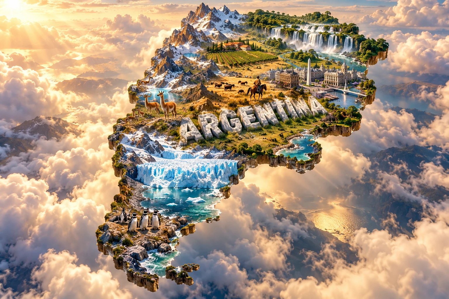
The Argentina artwork combines Patagonian glaciers, Andes peaks, Iguazú Falls, Pampas grasslands, Buenos Aires-inspired architecture, vineyards, gaucho imagery, guanacos and penguins. The floating terrain and monumental “ARGENTINA” lettering compress thousands of kilometers into one national portrait.
The elements are geographically separate. Iguazú lies in the subtropical northeast; the highest Andes and vineyards occupy the west; the Pampas spread across the center-east; glaciers lie in the Patagonian Andes; and penguin colonies occur at selected Atlantic coastal sites. Guanacos do not inhabit Buenos Aires streets, and gaucho culture is not a universal lifestyle.
The image is a conceptual artistic composition. The landmarks, wildlife and landscapes are combined for educational visualization and are not shown at their true geographic positions or scale. It is not a satellite map, an exact glacier record or a wildlife-range map.
12. Interesting Facts About Argentina
- Argentina extends about 3,700 kilometers from its subtropical north toward Tierra del Fuego.
- Aconcagua is the highest mountain outside Asia at 6,961 meters.
- The Nazca Plate descending beneath South America helped raise the Andes.
- The Andes create a rain shadow that makes much of Patagonia dry.
- The Paraná and Uruguay rivers meet in the Río de la Plata estuary.
- Pampas soils developed from fine sediment and organic matter supplied by grasslands.
- Iguazú Falls crosses layers of ancient flood basalt rather than one isolated cliff.
- Perito Moreno is only one glacier; its behavior does not represent every Patagonian glacier.
- Jaguars survive only in fragmented northern populations within Argentina.
- Magellanic penguins breed at particular Patagonian coastal colonies.
- Tango is shared Río de la Plata heritage of Argentina and Uruguay.
- Mate is also shared across several South American countries rather than being exclusively Argentine.
- Argentina contains 18 recognized terrestrial ecoregions.
- The country uses one time zone, UTC−3, across its long east–west span.
- Argentina's final 2022 census became the basis for revised population projections through 2040.
13. Short Quiz
-
What tectonic process helped form the Andes? A. Nazca Plate subduction beneath South America B. Coral reef growth C. Wind deposition alone D. Atlantic tides
-
Why is much of Patagonia dry? A. The Andes create a rain shadow B. It lies on the equator C. It has no mountains nearby D. The Paraná drains all clouds away
-
Where are jaguars found in Argentina? A. Throughout the entire country B. In fragmented northern habitats C. Only on Patagonian beaches D. In Antarctic waters
-
Which rivers meet to form the Río de la Plata? A. Colorado and Negro B. Paraná and Uruguay C. Amazon and Orinoco D. Pilcomayo and Chubut
-
How should the 3D artwork be interpreted? A. As an exact geographic map B. As one real landscape C. As a conceptual combination of distant features D. As a glacier-monitoring image
Answer key: 1-A, 2-A, 3-B, 4-B, 5-C.
14. Related Learning
Suggested internal-link topics:
- Chile Explained: Andes, Atacama, Glaciers and Coast
- Bolivia Explained: Altiplano, Salt Flats and Indigenous Cultures
- Paraguay Explained: Rivers, Chaco and Wetlands
- Uruguay Explained: Grasslands, Coast and Río de la Plata
- How the Andes Mountains Formed
- Why Patagonia Is So Dry and Windy
- How Glaciers Carved Southern Patagonia
- How the Paraná River Builds Its Delta
- Why the Pampas Has Such Fertile Soil
- How Iguazú Falls Formed in Ancient Basalt
15. Sources
- INDEC — population estimates and projections based on the 2022 census
- United Nations Data — Argentina country profile
- World Bank — Argentina overview
- World Bank — Argentina Country Economic Memorandum
- Argentina National Meteorological Service — Climate Atlas 1991–2020
- U.S. Geological Survey — South America seismotectonics
- Argentina National Parks Administration — protected regions and biodiversity
- Argentina government — protected areas and conservation
- INTA — land-cover change in the South American Pampas
- UNESCO — Argentina's World Heritage properties
- UNESCO — Tango
- UNESCO — Argentina lists and nominations