

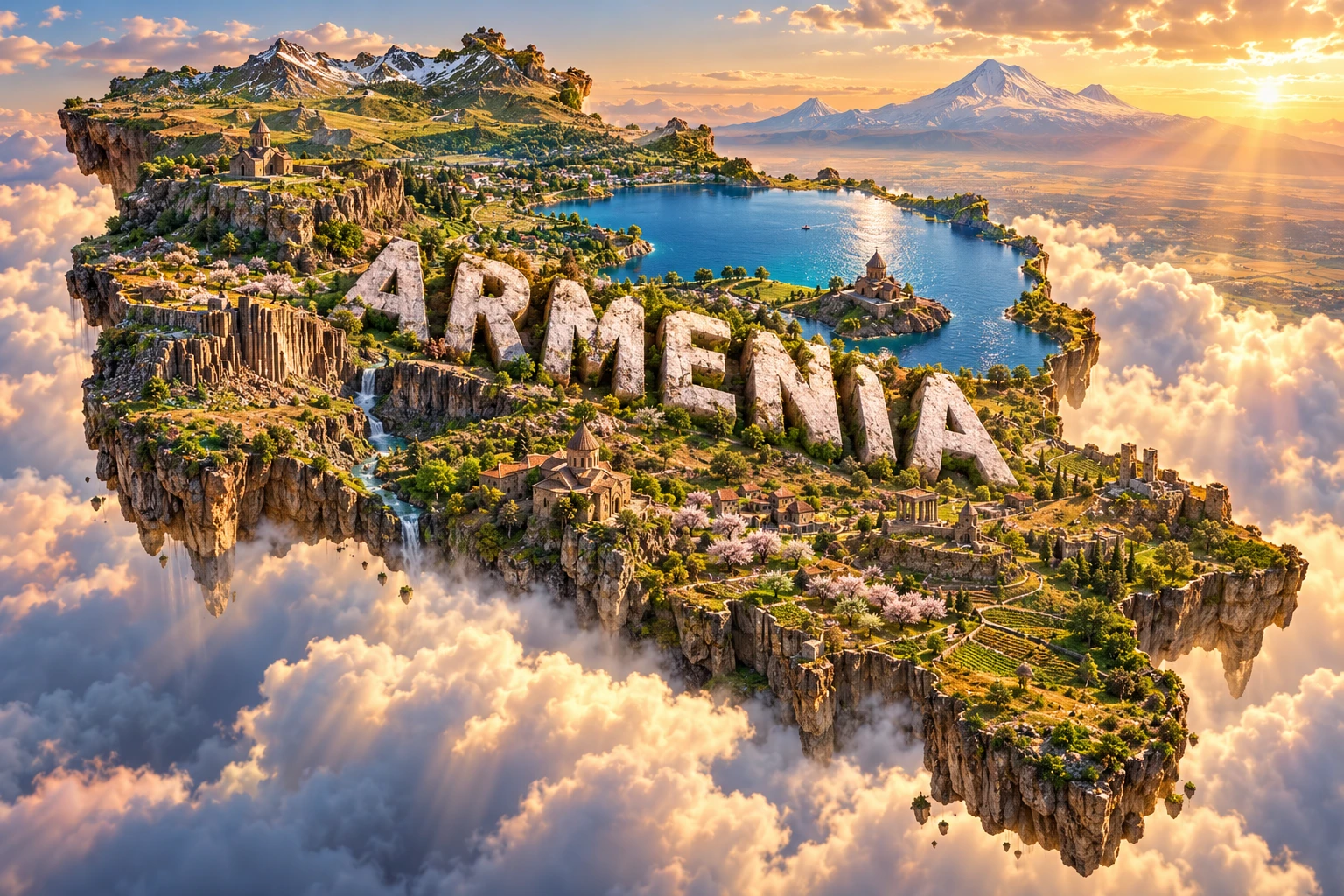
Armenia is a landlocked country of mountains, volcanic plateaus and deep valleys in the South Caucasus. Lake Sevan fills a high basin, while farms, towns, forests and centuries-old stone churches occupy very different elevations.
This landscape developed where the Arabian and Eurasian tectonic plates converge. Crustal compression raised the region, faults created serious earthquake hazards, and past volcanic eruptions spread lava and ash across the highlands. Geography has shaped Armenia's water supply, farming, transport, wildlife and distinctive tradition of building with local stone.
1. Where Is Armenia?
Armenia lies in the South Caucasus, at a historic crossroads between Europe and Asia. It borders Georgia to the north, Azerbaijan to the east, Iran to the south and Turkey to the west. The Azerbaijani exclave of Nakhchivan also borders Armenia in the southwest.
Overland connections matter greatly to the economy, and closed borders with Turkey and Azerbaijan limit some routes. Yerevan, the capital and largest city, stands on the Ararat Plain. Other important cities include Gyumri and Vanadzor.
Mount Ararat dominates many views from the Ararat Plain and has profound cultural importance for Armenians, but both of its summits are in present-day Turkey. Armenia's highest mountain is Mount Aragats, northwest of Yerevan.
2. Quick Country Facts
- Official name: Republic of Armenia
- Capital: Yerevan
- Region: South Caucasus
- Area: Approximately 29,743 square kilometers
- Population: About 3.09 million in 2025, according to the World Bank; estimates differ with methodology and migration
- Currency: Armenian dram (AMD)
- Official language: Armenian; Russian is widely understood, and Yezidi and other minority languages are spoken
- Time zone: Armenia Time (UTC+4), with no seasonal clock change
- Highest point: Mount Aragats, about 4,090 meters
- Largest lake: Lake Sevan, approximately 1,400 square kilometers
- Major rivers: Aras, Hrazdan, Debed, Akhuryan and Vorotan
Population figures should be dated because international models, resident counts and migration estimates can differ.
3. Geography and Landscape
Armenia is predominantly mountainous and lies mostly between about 1,000 and 2,500 meters above sea level. Much of the country consists of uplands rather than one continuous mountain chain: volcanic massifs, lava plateaus, folded ranges and river-cut valleys fit together across a compact area.
Mount Aragats is a broad, four-peaked volcanic massif. The Geghama Highlands contain volcanic cones and lava fields. In the south, the Zangezur Mountains rise steeply above Syunik's valleys, while Lesser Caucasus ranges extend through the north and east.
The Ararat Plain is Armenia's main lowland. The Aras River and sediments from surrounding highlands helped form its level surface. Yerevan and much irrigated agriculture are concentrated here, including vineyards and orchards.
Lake Sevan occupies a high tectonic and volcanic basin at roughly 1,900 meters. It is Armenia's largest lake and a major freshwater store, fish habitat, recreation area and source of water for irrigation and energy. Changes made to its water level during the Soviet period damaged shoreline wetlands and ecosystems; later management has sought to raise and stabilize the lake while controlling pollution and invasive species.
Armenia's rivers are generally short and fast because relief is steep. The Hrazdan drains Lake Sevan toward the Aras; the Debed crosses the forested north, and the Vorotan crosses the south. Reservoirs and irrigation networks help manage seasonal flows.
Northern Armenia includes relatively moist oak, beech and hornbeam forests. Central and western basins have steppe and dry grassland, while the warm, low Aras valley includes semidesert vegetation. Above the tree line, subalpine and alpine meadows reach toward rocky summits. These habitats occur in bands shaped by altitude, slope and rainfall.
4. Why Does Armenia Look Like This?
Armenia's landscape is part of a wide collision zone. The Arabian Plate is moving northward into Eurasia, squeezing and shortening the crust across the Caucasus and neighboring regions. Instead of producing one simple boundary, this pressure is distributed through folds, thrust faults and strike-slip faults. Uplift over millions of years created high plateaus and mountains.
The collision remains active. The destructive 1988 Spitak earthquake killed tens of thousands and demonstrated how fault movement, vulnerable buildings and settlement can combine into a disaster. Risk reduction depends on seismic construction, monitoring and preparedness—not precise earthquake prediction.
Volcanism added another layer. During the geologically recent past, eruptions from Aragats, the Geghama Highlands and other centers spread lava, ash and fragmented volcanic material across older rocks. Cooling lava formed basalt landscapes; erosion later carved cliffs and gorges through them. At Garni Gorge, column-like basalt joints formed as thick lava cooled and contracted, producing the formation popularly called the Symphony of Stones.
Water, ice and gravity further reshaped the terrain. Rivers cut valleys, landslides moved material downslope, and ice-age glaciers sculpted high mountains. Snowmelt remains vital to rivers and reservoirs.
Lake Sevan's basin developed through both tectonic movement and volcanic processes that affected drainage. It is not a volcanic crater lake. The surrounding highlands enclosed a large basin, and natural outlets and human water engineering have controlled its level over time.
Local geology also influenced architecture. Builders used abundant volcanic tuff and basalt for churches, khachkars, houses and civic buildings. Yerevan's pink and warm-toned facades owe much to varieties of volcanic tuff, linking the built environment directly to Armenia's geological history.
5. Climate
Armenia has a strongly continental highland climate. Summers are usually hot and dry in low valleys, while winters can be cold and snowy. Because elevation changes quickly, nearby locations can experience very different temperatures, frost seasons and precipitation.
The Ararat Plain has dry, sunny summers and relatively low rainfall. Irrigation is essential for much farming there. High plateaus and mountain basins have longer, colder winters, and the highest slopes retain snow far into the warm season. Lake Sevan slightly moderates temperatures close to its shores but does not eliminate harsh winter weather.
Northern and northeastern slopes receive more moisture and support forest. Interior basins and the Aras valley are drier because mountain barriers affect the movement of moist air. Spring and early summer provide much of the annual precipitation in many areas, often through showers and thunderstorms; hail can seriously damage crops.
Climate change is increasing heat and pressure on water resources. The World Bank identifies drought, floods, heat, hail, landslides and changing agricultural conditions among Armenia's risks. Earlier snowmelt and greater evaporation can make it harder to balance drinking water, ecosystems, hydropower and irrigation, particularly during dry years.
6. Wildlife and Ecosystems
Armenia's elevation range creates semidesert, steppe, forest, wetland, subalpine and alpine ecosystems within a small territory. It also preserves wild relatives of cultivated plants, including cereals and fruit species important to agricultural biodiversity.
The endangered Persian leopard is exceptionally rare in Armenia. Camera traps document it mainly in rugged southern landscapes and corridors connected to Iran and the wider Caucasus. It is not common or distributed nationwide.
Bezoar goats use steep rocky terrain, especially in the south, while Armenian mouflon survives in restricted dry mountain habitat. Brown bears, wolves, Eurasian lynx, wild boar, roe deer and foxes occur in suitable regions, not uniformly nationwide. Wildlife corridors are important because roads, settlements, mining and other development can fragment small populations.
Lake Sevan and its wetlands support migratory and breeding birds. The Armenian gull has an important breeding population there. Sevan trout is native to the lake, but water-level change, habitat damage, overfishing and introduced species have affected its populations. Conservation requires attention to the entire lake ecosystem rather than a single species.
Protected landscapes include Dilijan National Park's forests, Lake Arpi's high wetlands, southern Arevik National Park and Khosrov Forest State Reserve. The community-linked Caucasus Wildlife Refuge supports leopard habitat and ecological corridors.
Major pressures include illegal hunting, overgrazing, forest degradation, mining impacts, water pollution, invasive species, fire and climate change. Protection works best when local livelihoods, scientific monitoring and connections between habitats are considered together.
7. Famous Landmarks and Natural Features
Lake Sevan is both a natural system and a human-shaped water landscape. Sevanavank, a monastic complex on what was once an island, overlooks the lake. Falling water levels connected the island to shore as a peninsula, a visible reminder that water management can transform geography.
Geghard Monastery and the Upper Azat Valley form a UNESCO World Heritage property. Parts of the medieval religious complex were cut directly into rock, integrating architecture with the cliffs. Nearby, Garni Temple is a colonnaded monument associated with pre-Christian Armenia, and Garni Gorge exposes striking basalt columns.
The Cathedral and Churches of Echmiatsin and the archaeological site of Zvartnots document the development of Armenian Christian architecture. UNESCO highlights their central-domed, cross-hall designs and their influence across the region. Echmiatsin remains the spiritual center of the Armenian Apostolic Church.
Haghpat and Sanahin are medieval monastic complexes in northern Armenia. Their churches, libraries and learning traditions represent a major period of Armenian religious architecture and scholarship from roughly the 10th to 13th centuries.
Tatev Monastery, above the Vorotan Gorge, became an important medieval religious and intellectual center. Its setting illustrates how plateaus and valley routes guided settlement.
Mount Aragats is Armenia's highest point and an enormous volcanic landform with four main summits around a central crater. Noravank, set among reddish cliffs, and the volcanic-rock cityscape of Yerevan show other relationships between geology and architecture.
Mount Ararat belongs in a discussion of Armenian cultural landscape but not in a list of natural features inside the country. Its image appears in art and national symbolism and is visible from Armenia, even though the mountain is across the border in Turkey.
8. People, Languages and Culture
Armenian is an independent branch of the Indo-European language family. Mesrop Mashtots developed the Armenian alphabet in the early fifth century, supporting religious translation, education and a lasting manuscript tradition. Eastern Armenian is the main standard in Armenia, while Western Armenian is important in many diaspora communities.
Most residents identify as ethnic Armenian, but the country is also home to Yezidis, Russians, Assyrians, Kurds and other communities. Languages, religious practices and experiences differ among them. Armenia also has a very large global diaspora formed through centuries of migration, trade, persecution and displacement.
Armenia is traditionally dated as the first state to adopt Christianity as a state religion, in 301 CE. The Armenian Apostolic Church has strongly influenced architecture, manuscripts, music and community life. Modern Armenia is constitutionally secular, and its residents include followers of other faiths as well as people without religious affiliation.
Stone carving is especially visible in khachkars: upright carved cross-stones with intricate geometric and plant motifs. UNESCO recognizes their symbolism and craftsmanship as living heritage. No two designs need be identical, and the knowledge is transmitted through craftspeople rather than belonging only to the medieval past.
The duduk is a double-reed woodwind traditionally made from apricot wood. Its sound accompanies songs, dances and social occasions. Kochari and other dances have regional and community variations. Carpet weaving, metalwork, ceramics, embroidery, manuscript illumination and contemporary visual arts add further traditions; none represents every Armenian household.
Armenian history includes ancient kingdoms and the kingdom of Urartu, periods under Roman, Persian, Arab, Byzantine, Seljuk, Mongol, Ottoman and Russian power, and changing forms of Armenian statehood. During World War I, Ottoman authorities carried out mass deportations and killings of Armenians in what is widely recognized as the Armenian genocide, creating deep and lasting diaspora consequences.
Armenia became a Soviet republic and regained independence in 1991. Conflict with Azerbaijan over Nagorno-Karabakh shaped the post-Soviet period. Azerbaijan took full control in September 2023, after which nearly the entire ethnic Armenian population fled to Armenia. The displacement continues to affect communities and public services.
9. Food
Armenian food varies by region, season and family, and shares ingredients and techniques with neighboring Caucasian and West Asian cuisines. Lavash is a thin wheat bread baked against the wall of a traditional clay oven. UNESCO recognizes its preparation and social meaning in Armenia as intangible cultural heritage.
Khorovats refers to grilled meats and vegetables prepared for meals and gatherings. Tolma uses grape leaves or vegetables filled with mixtures that may include meat, rice, herbs and pulses. Harissa is a slow-cooked wheat and meat dish, while spas is a yogurt-based soup often made with grain and herbs.
Gata is a family of sweet breads or pastries with regional forms. Apricots, grapes, pomegranates, walnuts and herbs are prominent in season. Winemaking has ancient archaeological evidence in the region and remains an active industry, but consumption and culinary practice differ among individuals and communities.
10. Economy and Major Industries
Services produce the largest share of Armenia's economy. Information technology, finance, retail, transport, education, health, hospitality and professional services are important, especially in Yerevan. A skilled workforce and diaspora connections have helped technology companies grow, though benefits are unevenly distributed.
Manufacturing includes food and beverages, metal products, machinery, pharmaceuticals, textiles, jewelry and electronics. Mining produces copper, molybdenum, gold and other minerals. It supplies exports but also raises questions about tailings, water, land restoration and community health.
Agriculture remains important for rural employment. Small and fragmented farms grow grapes, apricots and other fruits, vegetables, potatoes and cereals and raise livestock. Output is vulnerable to drought, hail, erosion and limited irrigation efficiency. Food processing connects farms to domestic and export markets.
Armenia imports much of its fuel. Electricity comes from nuclear power, natural gas, hydropower and growing solar generation. Efficiency and diversification can reduce exposure to fuel shocks, although every source has trade-offs.
The World Bank classifies Armenia as an upper-middle-income economy. Recent growth has been supported by services, construction, consumption and investment, but the country's small market, landlocked position, concentrated trade routes and regional tensions remain constraints. Current growth, poverty and trade figures can change quickly and should be dated whenever used.
11. What the 3D Visual Represents
The Armenia artwork combines rugged highlands, Lake Sevan, monasteries, volcanic formations, apricot orchards, Armenian stone architecture and Mount Ararat on the horizon. The floating national outline and monumental “ARMENIA” lettering create a compact visual story about terrain, agriculture, building traditions and cultural memory.
These elements need geographic context. Lake Sevan occupies a high basin in eastern-central Armenia; major monastery complexes stand in different regions; orchards are concentrated in suitable valleys; and volcanic landscapes extend across several uplands. Mount Ararat is visible from Armenia and culturally significant, but it is located in Turkey. Its presence on the horizon does not place it inside Armenia's borders.
The image is a conceptual artistic composition. The landmarks, wildlife and landscapes are combined for educational visualization and are not shown at their true geographic positions or scale. It is not a satellite map, geological survey or record of one real viewpoint.
12. Interesting Facts About Armenia
- Armenia is landlocked and lies in the South Caucasus between Georgia, Azerbaijan, Iran and Turkey.
- Most of the country is more than 1,000 meters above sea level.
- Mount Aragats, not Mount Ararat, is the highest point in Armenia.
- Mount Ararat is in Turkey but remains visible from Armenia and central to Armenian cultural symbolism.
- Lake Sevan is a high-altitude freshwater lake at roughly 1,900 meters above sea level.
- Collision between the Arabian and Eurasian plates helps uplift the region and creates earthquake hazards.
- Garni Gorge's basalt columns formed as lava cooled, contracted and fractured.
- Yerevan's characteristic pink stone comes from volcanic tuff used in many buildings.
- Armenian forms their own branch of the Indo-European language family.
- The Armenian alphabet was developed by Mesrop Mashtots in the early fifth century.
- Parts of Geghard Monastery were carved into living rock.
- The Persian leopard is endangered and extremely rare, with records concentrated in southern Armenia.
- The Armenian gull has an important breeding population around Lake Sevan.
- Lavash making, duduk music and khachkar craftsmanship are recognized by UNESCO as living heritage.
- Armenia uses UTC+4 throughout the year without daylight-saving clock changes.
13. Short Quiz
-
Which mountain is the highest point in Armenia? A. Mount Ararat B. Mount Aragats C. Mount Elbrus D. Mount Kazbek
-
What process helped raise Armenia's highlands? A. Collision between the Arabian and Eurasian plates B. Coral reef growth C. Atlantic seafloor spreading inside Armenia D. Wind deposition alone
-
Why do basalt columns form? A. Trees become stone instantly B. Cooling lava contracts and fractures C. Rivers stack separate blocks D. Glaciers manufacture basalt
-
Where is Armenia's Persian leopard most closely associated? A. Every city and farm B. Lake Sevan's open water C. Rugged southern habitats and wildlife corridors D. The entire Ararat Plain
-
How should the 3D artwork be interpreted? A. As an exact satellite map B. As a conceptual combination of distant features C. As proof that Mount Ararat lies in Armenia D. As a wildlife distribution map
Answer key: 1-B, 2-A, 3-B, 4-C, 5-B.
14. Related Learning
Suggested internal-link topics:
- Georgia Explained: Caucasus Mountains, Wine and Black Sea Landscapes
- Azerbaijan Explained: Caspian Coast, Mud Volcanoes and Culture
- Iran Explained: Plateaus, Deserts, Mountains and Ancient Cities
- Turkey Explained: Tectonic Plates, Anatolia and Cultural Crossroads
- How the Caucasus Mountains Formed
- Why Armenia Has So Many Volcanic Landscapes
- How Lake Sevan's Water Level Changed
- Why the South Caucasus Has Major Earthquakes
- How Volcanic Tuff Shaped Yerevan's Architecture
- How Wildlife Corridors Help the Persian Leopard
15. Sources
- World Bank — Armenia overview
- World Bank Data — Armenia population
- United Nations Data — Armenia country profile
- World Bank — Armenia Country Climate and Development Report
- FAO — Armenia at a glance
- U.S. Geological Survey — tectonics and earthquake hazards in Armenia
- U.S. Geological Survey — the 1988 Spitak earthquake
- UNESCO — World Heritage properties in Armenia
- UNESCO — Monastery of Geghard and the Upper Azat Valley
- UNESCO — Cathedral and Churches of Echmiatsin and Zvartnots
- UNESCO — Monasteries of Haghpat and Sanahin
- UNESCO Intangible Cultural Heritage — lavash in Armenia
- UNESCO Intangible Cultural Heritage — Armenian duduk music
- UNESCO Intangible Cultural Heritage — Armenian khachkars
- IUCN — Persian leopard conservation in Armenia