

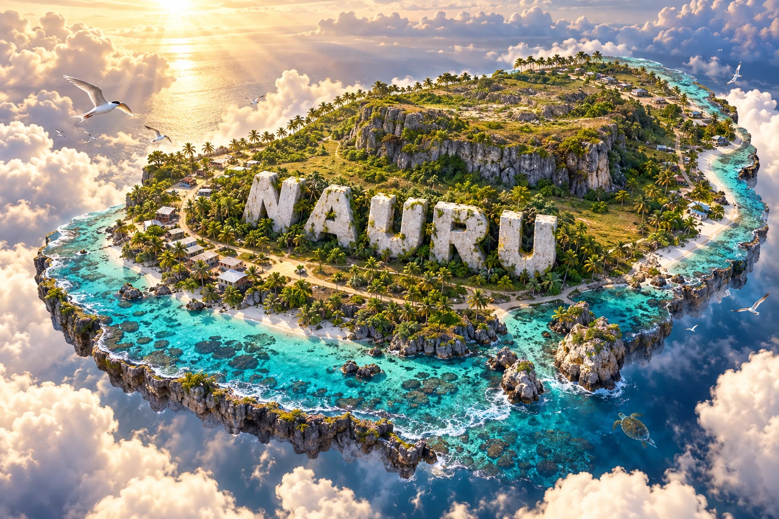
Nauru is a single raised coral island in the central Pacific and the world's smallest independent republic by land area. A narrow inhabited coastal belt surrounds a limestone plateau known as Topside. For much of the twentieth century, rich phosphate deposits made the island unusually wealthy, but mining removed soil and vegetation from most of the interior and exposed jagged limestone pinnacles. Nauru therefore offers a powerful lesson in how geology, colonial extraction, environmental limits and national development can become inseparable.
1. Where Is Nauru?
Nauru lies in the western-central Pacific Ocean, just south of the equator. It belongs to the Micronesian region of Oceania. Its nearest sovereign neighbors include Kiribati to the east, the Marshall Islands to the northeast and the Federated States of Micronesia farther northwest. Papua New Guinea and Solomon Islands lie well to the southwest.
The republic consists of one oval-shaped island surrounded by a coral reef. It has no land borders, outer islands or separate inhabited atolls. A paved road circles its roughly 30-kilometre coastline, and most homes and infrastructure occupy the low coastal strip.
Nauru has no legally designated official capital. Government offices and Parliament are in Yaren District, which is commonly described as the de facto capital. This distinction matters: calling Yaren the official capital would be inaccurate.
2. Quick Country Facts
- Official name: Republic of Nauru; in Nauruan, Repubrikin Naoero
- Capital: No official capital; government offices are in Yaren District
- Region: Micronesia, Oceania, central Pacific
- Area: About 21 square kilometres
- Population: 11,680 in the 2021 census; the World Bank estimated 11,947 in 2024
- Currency: Australian dollar
- Languages: Nauruan, or Dorerin Naoero; English is widely used in government and commerce
- Time zone: Nauru Time, UTC+12
- Highest area: Command Ridge, roughly 65 metres above sea level
- Major inland water body: Buada Lagoon, a brackish landlocked lagoon
- Rivers: None
- Independence: 31 January 1968
- Political system: Parliamentary republic
- World Heritage: No UNESCO World Heritage properties as of 2026
Nauru is smaller than many cities and has only 14 administrative districts. Because national figures involve a small population, migration or a few hundred people can noticeably change percentages.
3. Geography and Landscape
Nauru's outer edge is a narrow coastal plain, generally a few hundred metres wide. Beaches and rocky reef flats surround much of the island. A fringing coral reef drops steeply into deep ocean because Nauru is the exposed summit of a much larger submarine feature.
Behind the coastal belt, coral-limestone cliffs and slopes rise to the central plateau. The interior is called Topside. Before large-scale mining it supported forest and productive soils in many depressions. Phosphate extraction removed material between hard limestone pinnacles, creating a rough landscape that is difficult to farm, build on or cross.
Buada Lagoon lies in a low central depression. It is not connected openly to the sea and is brackish rather than a large freshwater reservoir. Small ponds and a thin groundwater lens exist, but contamination and salt make groundwater unreliable for drinking.
The island has no rivers because it is tiny and its limestone is highly porous. Rain rapidly infiltrates cracks or flows short distances toward the coast. Safe water therefore comes mainly from rainwater collection and desalination, with storage capacity becoming critical during drought.
4. Why Does Nauru Look Like This?
Nauru began as an oceanic volcano on the Pacific Plate. As volcanic activity ended and the foundation changed relative to sea level, reef-building organisms created thick carbonate deposits around and above it. Later uplift raised former reef limestone above the ocean, producing a raised coral island rather than a low atoll.
Rainwater absorbed carbon dioxide and became weakly acidic. Over long periods it dissolved limestone along joints and cavities, a process called karstification. This produced an irregular surface of pits, depressions and resistant pinnacles across the plateau.
The phosphate's origin is more complex than the common phrase “fossilized bird droppings.” Seabird guano probably contributed phosphorus, but scientific studies also point to chemical replacement of reef limestone, repeated dissolution and reprecipitation, marine-derived phosphorus and possible volcanic influence. The deposits accumulated and changed over hundreds of thousands of years within the porous karst landscape.
Mining removed phosphate-rich material that had filled spaces between limestone pinnacles. The dramatic spires visible today are therefore partly natural karst forms and partly an exposed industrial landscape. They should not be mistaken for an untouched plateau.
5. Climate
Nauru has a hot, humid tropical marine climate. Temperatures vary less through the year than in temperate countries because the island lies close to the equator and is surrounded by warm ocean. Trade winds provide some relief, especially near the coast.
Rainfall is highly variable. Nauru is strongly influenced by the El Niño–Southern Oscillation. Some El Niño periods bring very wet conditions, while prolonged La Niña phases can contribute to serious drought. There is no reliable river or large freshwater lake to buffer a long dry spell.
Tropical cyclones rarely make direct landfall so near the equator because the Coriolis effect is weak, but distant storms can still produce large waves, damaging swell and disrupted shipping. Coastal flooding also comes from unusually high tides and wave events.
Climate change is raising sea level, increasing heat and altering marine conditions. Coastal erosion, saltwater intrusion, coral heat stress and unreliable rainfall threaten the narrow area where most people live. Rehabilitation of Topside could provide more room for settlement and food production, but restoring mined terrain is technically difficult and costly.
6. Wildlife and Ecosystems
Nauru's small size and long history of land alteration limit terrestrial biodiversity. The 2024–25 United Nations national study reports no native land mammals. Geckos, skinks, insects and birds make up much of the visible native land fauna.
The Nauru reed warbler is endemic, meaning it occurs naturally nowhere else. It uses scrub, regenerating vegetation and some human-modified habitats, including parts of Topside. Its survival shows that altered landscapes can retain biological value, but its tiny global range makes it vulnerable to habitat loss, invasive species and extreme events.
Noddy terns, frigatebirds and migratory shorebirds use the island. Noddy birds have cultural and food significance, but seabirds are associated with nesting or roosting areas rather than every settlement. The image's generic seabirds should not be assigned to a species without clearer visual evidence.
Coral reefs and open ocean support reef fish, tuna, sharks, rays, turtles and other marine life. Green turtles have been reported nesting, but numbers and timing vary. Nauru's narrow reef shelf drops quickly into deep pelagic water, so coastal and open-ocean ecosystems lie unusually close together.
Mining, waste, sewage, overharvesting, invasive species, coral bleaching and ocean acidification create conservation pressures. Healthy reef habitat is important not only for wildlife but also for food, shoreline protection and culture.
7. Famous Landmarks and Natural Features
Topside's phosphate pinnacles are the clearest physical record of Nauru's mining history. They reveal the limestone skeleton left after removal of phosphate-rich soil. The area is educationally important as an example of resource extraction and rehabilitation, not simply an unusual scenic landscape.
Buada Lagoon is a palm-lined brackish lagoon within the central depression. It was historically associated with food cultivation and settlement, but its water is not a dependable national drinking supply.
Anibare Bay forms one of the island's broadest coastal embayments. Reef, beach and nearshore water demonstrate how wave action and coral geology shape the coast. Anibare Harbour provides a safer landing area, though Nauru's exposed ocean conditions remain challenging.
Command Ridge is the island's highest area. Japanese forces built defensive positions and installed equipment there during their occupation in the Second World War. Remaining structures must be understood in the context of invasion, forced labor, deportation and wartime suffering.
Parliament House and government buildings in Yaren represent Nauru's modern independent state. The nearby international airport occupies a significant part of the narrow coastal plain, illustrating how tightly infrastructure must fit onto the island.
The cantilever structures at Aiwo were built to load phosphate onto ships beyond the shallow reef. They symbolize both the engineering required by Nauru's steep offshore geography and the economy's long dependence on one mineral.
8. People, Languages and Culture
Nauruans call their island Naoero. The Nauruan language is Micronesian, although its exact relationship to neighboring languages reflects a complex history of contact. English is widely used in administration, schooling and business. Residents also include people with I-Kiribati, Tuvaluan, Chinese, Australian and other Pacific and international backgrounds.
Traditional social organization includes twelve named tribes or clans represented by the twelve-pointed star on the national flag. Modern identity cannot be reduced to those categories, and individual family histories vary. Land ownership, kinship and inheritance remain important in a country where nearly every parcel is socially and economically significant.
Fishing knowledge, canoe traditions, songs, dance, storytelling, pandanus weaving and coconut use connect Nauru with a wider Pacific cultural world. Churches play a large role in community life. Modern Nauruan culture also includes contemporary music, sport, digital media and connections maintained through migration and overseas education.
Germany annexed Nauru in 1888. Australian forces occupied it in 1914, after which Australia administered a League of Nations mandate and later a United Nations trust territory on behalf of Australia, Britain and New Zealand. During Japanese occupation from 1942, many Nauruans were deported to Chuuk; a large proportion died before survivors returned in 1946.
Nauru became independent in 1968 and took control of the phosphate industry in 1970. Phosphate income funded public services and overseas investments, but depletion, poor investment decisions and economic shocks later produced severe financial problems. This history is not a simple story of wealth lost: colonial powers extracted large quantities before independence, and the environmental cost remains on Nauruan land.
9. Food
Fish and seafood are important local foods, including reef fish and tuna from deeper water. Coconut, pandanus, breadfruit and limited garden crops have traditional uses. Buada's relatively sheltered soils historically supported bananas and other plants.
Today, Nauru imports much of its food because mining degraded land, freshwater is scarce and transport links are limited. Rice, flour, canned meat, frozen foods and other imported products are common. Australian, Chinese and other Pacific influences are visible in everyday meals.
Dependence on processed imports and limited access to affordable fresh food contribute to major nutrition and non-communicable-disease challenges. Current agricultural projects emphasize soil restoration, household gardens, agroforestry and climate-smart food production. Describing this issue requires attention to environment and access, not blaming individual choices.
10. Economy and Major Industries
Phosphate mining once dominated nearly every part of Nauru's economy. Primary deposits have been heavily depleted, but secondary phosphate recovery and processing have continued at varying levels. Rehabilitation of mined land is both an environmental need and a potential source of work.
The country earns revenue from fishing access within its large exclusive economic zone, public services, international assistance and arrangements with overseas partners. Aviation, port operations, construction, retail and small service businesses also provide jobs. Australia-linked regional processing arrangements have generated substantial revenue at different times, but their scale and operation have changed, making them an unstable foundation for long-term planning.
Nauru imports most fuel, machinery, manufactured goods and food. Geographic isolation raises freight costs, while a narrow economic base makes national income sensitive to policy changes abroad. Regional labor schemes and remittances provide opportunities for some households.
Future resilience depends on better land and water management, education, public health, transparent finance, renewable energy, fisheries stewardship and economic activities that do not repeat the environmental costs of phosphate extraction.
11. What the 3D Visual Represents
The Nauru artwork combines a turquoise coral coastline, tropical palms, a raised central plateau, coastal settlements, seabirds and Pacific marine life. The reef and deep-blue ocean represent a small island perched above steep submarine slopes. Palms and homes refer mainly to the habitable coastal belt and Buada area.
The raised plateau represents Topside, but an accurate educational interpretation must acknowledge that mining has severely transformed much of it. Seabirds refer to Nauru's ecological and phosphate history, while fish and other marine forms symbolize reef and open-ocean biodiversity rather than species occurring everywhere around the shore.
The image is a conceptual artistic composition. The landmarks, wildlife and landscapes are combined for educational visualization and are not shown at their true geographic positions or scale. Its lush plateau should not be read as a current land-cover map, and it does not show the full extent of mining damage.
12. Interesting Facts About Nauru
- Nauru is the world's smallest independent republic by land area, covering about 21 square kilometres.
- It is the third-smallest sovereign state by area, after Vatican City and Monaco.
- Nauru has no officially designated capital; Yaren is the seat of government.
- A road around the island is only about 30 kilometres long.
- The 2021 census counted 11,680 residents.
- Nauru is a raised coral-limestone island built above an ancient volcanic foundation.
- The phosphate deposits did not form through bird guano alone; marine chemistry and alteration of reef limestone also played roles.
- Mining has severely degraded roughly 80 percent of the island, especially the central plateau.
- Buada Lagoon is brackish and cannot supply all of Nauru's drinking water.
- The country has no rivers, so rainwater harvesting and desalination are essential.
- The Nauru reed warbler is found naturally nowhere else on Earth.
- Nauru uses the Australian dollar but is an independent country.
- It joined the United Nations in 1999.
- Command Ridge rises only about 65 metres but is still the island's highest area.
- Nauru controls an ocean area vastly larger than its 21-square-kilometre land surface through its exclusive economic zone.
13. Short Quiz
-
What is Nauru's official capital? A. Yaren B. Aiwo C. Nauru City D. It has no officially designated capital
-
Why does Nauru have no rivers? A. Its small, porous limestone island drains water quickly B. It receives no rain at all C. Every river was dammed D. It lies below the ocean
-
What transformed most of Nauru's central plateau? A. Glacial erosion B. Phosphate mining C. A recent volcanic eruption D. River flooding
-
Which bird is endemic to Nauru? A. Emperor penguin B. Nauru reed warbler C. Bald eagle D. Kiwi
-
How should the 3D visual be interpreted? A. As a current land-cover survey B. As a conceptual artistic composition C. As a nautical chart D. As a mining permit map
Answer key: 1-D, 2-A, 3-B, 4-B, 5-B.
14. Related Learning
- Kiribati Explained: Atolls, Ocean Geography and Climate — compare a raised island with low coral atolls.
- Marshall Islands Explained: Atolls, Lagoons and Sea-Level Risk — explore another Micronesian environment.
- Federated States of Micronesia Explained: Volcanic Islands, Reefs and Culture — compare island origins.
- How Raised Coral Islands Form — connect volcanic foundations, reefs and uplift.
- Where Nauru's Phosphate Came From — investigate competing geological evidence.
- How Phosphate Mining Changed Nauru — connect extraction with land, economy and sovereignty.
- Why Small Islands Struggle with Freshwater — study rain, groundwater lenses and desalination.
- How El Niño Changes Pacific Island Rainfall — explain drought and extreme rain.
- The Nauru Reed Warbler: Life on One Small Island — explore endemism and extinction risk.
- How Coral Reefs Protect Island Coasts — connect biology, waves and climate change.
15. Sources
- Pacific Community, Nauru 2021 census results summary
- Pacific Community, Nauru 2024–2025 Household Income and Expenditure Survey
- Government of Nauru, the people and Nauruan language
- Government of Nauru, Constitution
- United Nations in Micronesia, Nauru national study 2024–25
- United Nations, Nauru climate change and migration report
- World Bank, Nauru data
- FAO, Nauru food-systems and land-rehabilitation project
- FAO, Nauru country priority product profile
- SPREP, Nauru climate vulnerability assessment
- SPREP, Nauru Rapid Biodiversity Assessment
- U.S. Geological Survey, physical and chemical properties of Nauru phosphate
- Oceanologica Acta, origin of Nauru phosphate deposits