

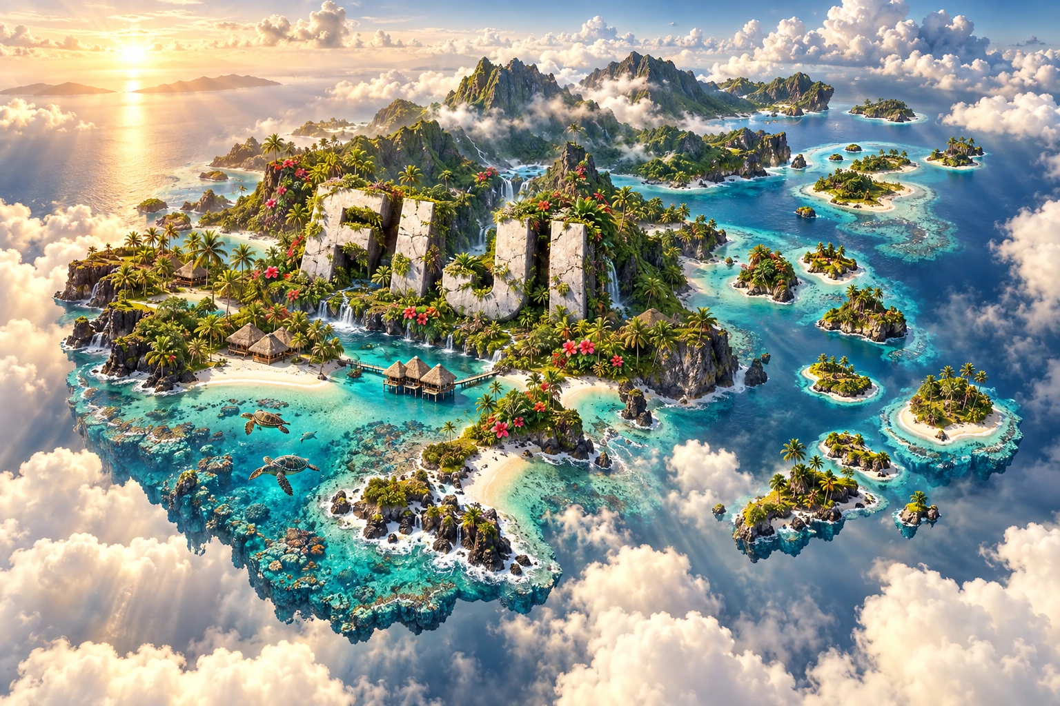
Fiji is a South Pacific archipelago built largely from ancient volcanic activity and reshaped by tropical rain, rivers, waves and coral growth. Its two largest islands contain steep forested mountains and most of the population, while hundreds of smaller islands range from high volcanic land to low coral and limestone formations.
The reefs and lagoons surrounding these islands are living ecosystems, not simply scenery. They reduce wave energy, support fisheries and create habitat, but face marine heat, pollution, sediment and storms. Fiji's geography therefore links plate tectonics, climate, biodiversity, culture and the economy unusually closely.
1. Where Is Fiji?
Fiji lies in Oceania, in the tropical South Pacific Ocean. It is northeast of New Zealand, east of Vanuatu, southwest of Samoa and west of Tonga. The International Date Line bends around the group so the entire country uses the same calendar date.
The country is an archipelago, commonly described as having about 333 islands, plus hundreds of smaller islets. Roughly one-third of the named islands are inhabited, although definitions and counts vary with the minimum size used.
Viti Levu is the largest island and contains Suva, the capital, as well as Nadi and Lautoka. Vanua Levu is the second largest. Together they account for most of Fiji's land and residents. Other important groups include the Mamanuca, Yasawa, Lomaiviti, Lau and Kadavu islands, while Rotuma lies far to the north and has a distinct Polynesian-influenced culture.
Fiji has a relatively small land area but an ocean jurisdiction vastly larger than its islands. Sea routes, reefs and fisheries are therefore central to understanding the country.
2. Quick Country Facts
- Official name: Republic of Fiji
- Capital: Suva, on Viti Levu
- Region: Melanesia, Oceania; South Pacific
- Land area: approximately 18,274 square kilometers
- Population: approximately 933,154 in 2025, according to the World Bank
- Currency: Fijian dollar (FJD)
- Official languages: English, iTaukei and Hindi under Fiji's constitutional framework
- Time zone: Fiji Time, UTC+12; seasonal daylight-saving use has changed over time
- Highest point: Mount Tomanivi, 1,324 meters, on Viti Levu
- Largest islands: Viti Levu and Vanua Levu
- Major river: Rewa River, the country's largest river system
- Independence: 10 October 1970, from Britain
“Fijian” is the shared citizenship term. iTaukei refers specifically to Indigenous Fijians, while Indo-Fijian describes citizens whose family histories are connected largely to labor migration from British India.
3. Geography and Landscape
Viti Levu and Vanua Levu are mountainous volcanic islands dissected by rivers and valleys. Mount Tomanivi rises in central Viti Levu, while forested ranges divide the island's wetter southeast from its drier northwest. Suva lies on the humid windward side; major sugar-growing districts occur mainly on the leeward west and north.
The Rewa River drains eastern Viti Levu into a broad delta near Suva. Other rivers, including the Sigatoka, Ba and Navua, connect steep interiors with coastal plains. Heavy rain can make them flood rapidly and carry sediment onto reefs.
Vanua Levu has volcanic ridges, bays and coastal plains. The Cakaulevu, or Great Sea Reef, extends along its northern side and includes barrier, patch, fringing and mangrove-associated reef habitats. Kadavu is bordered by the Great Astrolabe Reef, while Beqa Lagoon lies south of Viti Levu.
Not every Fijian island is geologically alike. Some are high volcanic islands with streams and deep soils. Others are uplifted limestone, coral cays or sand islets that have thin soils and limited freshwater. Lagoons form where reefs enclose calmer water around an island or shallow platform.
Mangrove forests occupy sheltered muddy coasts and estuaries. They trap sediment, provide nursery habitat and reduce erosion, while seagrass beds support fish and marine turtles. Beaches are dynamic deposits moved by waves and currents, not permanent strips of sand.
4. Why Does Fiji Look Like This?
Fiji lies within a highly complex boundary zone between the Australian and Pacific plates. Subduction, volcanic arcs, microplates and back-arc spreading reorganized this region over millions of years. Magma generated in earlier arc systems built much of the foundation of Viti Levu, Vanua Levu and other high islands.
Fiji is not a simple hotspot chain like Hawaii. Its geology records changing subduction directions, arc breakup, faulting, uplift and rotation between the Vanuatu and Tonga trenches. Many volcanoes that constructed the main islands are now extinct or deeply eroded, even though earthquakes and active volcanism occur elsewhere in the surrounding plate-boundary region.
Once islands rose above the sea, tropical weathering broke volcanic rock into soil. Rivers cut valleys and transported sediment to coastal plains. Landslides on steep wet slopes and waves along the coast continued to reshape the land.
Coral organisms then built reefs in warm, sunlit, shallow water. Reef frameworks grow as corals and other organisms add calcium carbonate, while waves break material into sand. A reef can form a fringe beside shore, a barrier separated by a lagoon, or patches on a platform. Reef growth must keep pace with subsidence and changing sea level, and it depends on water quality and temperature.
5. Climate
Fiji has a warm tropical maritime climate. Temperatures vary less through the year than in temperate countries, but rainfall and storm risk have strong seasons. The warmer, wetter season generally runs from November to April; the cooler, drier season is broadly May to October.
Southeast trade winds rise over the mountains of Viti Levu and Vanua Levu, cool and release rain. This creates wet windward southeastern slopes and a rain shadow in western and northwestern districts. The contrast helps explain why lush forest and irrigated or drought-sensitive sugar country can occur on the same island.
Tropical cyclones are most likely during the southwest Pacific cyclone season, generally November to April, with peak activity often early in the calendar year. A cyclone does not need to pass directly over an island to cause dangerous rain, wind, waves, landslides or flooding.
El Niño and La Niña shift rainfall and cyclone patterns, but their effects differ by event and location. Sea-level rise, coastal erosion, saltwater intrusion and marine heat compound existing hazards. Some low-lying communities have planned or undertaken relocation, while mountainous islands also face river floods and slope failure.
6. Wildlife and Ecosystems
Fiji's long isolation produced species found nowhere else. Native land mammals are mostly bats; many rats and other mammals arrived with people. Forests contain endemic birds, plants, insects and reptiles, including several Fijian iguanas.
The critically endangered Fijian crested iguana survives naturally on only a few western islands, according to IUCN conservation work. It is not distributed across the entire archipelago. Habitat clearing, fire, invasive predators and illegal collection have threatened island reptiles.
Coral reefs support hard and soft corals, reef fish, mollusks, crustaceans, sharks and many other organisms. Mangroves, seagrass and reefs function as connected habitats; damaging one can affect fisheries or species that move among them.
Green and hawksbill turtles use Fijian waters. Turtles may feed in seagrass or reef habitat and nest on suitable beaches, but nesting is localized and seasonal. They face entanglement, illegal harvest, coastal lighting, habitat loss, plastic and warming sand.
Marine heat can make corals expel their symbiotic algae, causing bleaching. Bleached coral is stressed rather than automatically dead, but prolonged heat can cause mortality. NOAA's monitoring placed Fiji at Alert Level 2 during part of early 2026, illustrating that even remote-looking reefs experience global ocean warming.
Community-managed fishing areas and traditional tabu closures can support recovery by temporarily restricting harvest. Their effectiveness depends on local rules, enforcement, ecological conditions and cooperation rather than the name alone.
7. Famous Landmarks and Natural Features
Levuka Historical Port Town, on Ovalau, is Fiji's only inscribed UNESCO World Heritage property. It was the first colonial capital and shows how a nineteenth-century port developed beside Indigenous settlements. Its significance includes cultural contact and colonial power, not merely picturesque old buildings. Suva replaced Levuka as capital in 1882.
Sigatoka Sand Dunes National Park protects a coastal dune system, archaeological evidence and native habitat on Viti Levu. Wind, waves, vegetation and sand supply continually influence the dunes. It remained on Fiji's UNESCO Tentative List in 2026, not the inscribed list.
Cakaulevu, the Great Sea Reef, borders northern Vanua Levu. Its barrier reefs, channels, mangrove islands and patch reefs support fishing communities and diverse marine life.
The Great Astrolabe Reef surrounds parts of Kadavu and neighboring islands. It illustrates how barrier reefs create sheltered channels and lagoons while meeting deep ocean water along outer slopes.
Bouma National Heritage Park on Taveuni protects rainforest, waterfalls and community-managed landscapes. Taveuni's high rainfall and volcanic soils support dense vegetation, but “Garden Island” is a nickname rather than a scientific classification.
Sovi Basin is a large, relatively intact forested basin on Viti Levu and a refuge for native species. Like Sigatoka and Yadua Taba's iguana sanctuary, it is a Tentative List property rather than World Heritage inscription.
8. People, Languages and Culture
Fiji's population includes Indigenous iTaukei, Indo-Fijians, Rotumans, Banabans, people of Chinese, European and other Pacific ancestry, and families of mixed heritage. National identity is shared, while communities retain distinct languages, religions and histories.
iTaukei language varieties belong to the Austronesian family. English is widely used in administration and education, while Fiji Hindi developed from languages brought by indentured laborers and subsequent generations. Rotuman is distinct and connected to Rotuma's history.
British colonial authorities brought about 60,000 indentured laborers from India between 1879 and 1916, many to work on sugar plantations. Their descendants shaped farming, business, politics, music, language and food. “Girmit,” derived from “agreement,” refers to this indenture system and its difficult legacy.
Within many iTaukei communities, vanua connects land, people, customary authority and belonging. Village and chiefly systems vary across the country and continue alongside elected government, churches, schools and urban life. A bure is a traditional building form constructed with local materials, but the visual's one house cannot represent every region or modern household.
Meke combines dance, song and oral narrative in forms shaped by particular communities and occasions. Yaqona, made from kava root, is used in formal welcomes, ceremonies and social gatherings. Protocol matters, and the practice should not be reduced to a novelty drink.
Christianity is prominent among many iTaukei communities. Hinduism, Islam, Sikhism and Christianity are practiced among Indo-Fijian and other communities. Diwali, Eid, Christmas and national observances reflect this plural society.
9. Food
Root crops such as cassava, taro and sweet potato are important, alongside breadfruit, plantain, coconut, leafy greens, seafood and meat. Food practices vary between islands, ethnic communities, cities and rural villages.
Kokoda uses raw fish cured in citrus and mixed with coconut milk, vegetables and seasoning. Lovo describes food cooked in an earth oven with heated stones; ingredients may include root crops, vegetables, fish or meat. Rourou is made from taro leaves, often with coconut milk.
Indo-Fijian cooking includes roti, dhal, curries, chutneys and sweets adapted to local ingredients. Chinese and other Pacific influences are also visible. Describing Fiji's cuisine only through resort seafood would miss plantation history, home gardens and everyday staples.
10. Economy and Major Industries
Services dominate Fiji's economy. Tourism supports accommodation, transport, food supply, retail and many small businesses, but dependence on visitor arrivals makes jobs and revenue vulnerable to cyclones, recessions and health crises.
Agriculture includes sugarcane, kava, taro, ginger, coconuts, fruit, vegetables and livestock. Sugar once dominated exports and remains important in western Viti Levu and Vanua Levu, although production, land arrangements and mill efficiency have changed over time.
Manufacturing includes food and beverages, garments, wood products, construction materials and bottled water. Fisheries supply domestic food and exports, while sustainable catch limits and enforcement are necessary to protect stocks. Gold has long been mined at Vatukoula.
Remittances from Fijians overseas are important to many households; the World Bank recorded them at about 7.1% of GDP in 2024. The World Bank estimated GDP growth of 3.2% in 2025, but national growth does not eliminate inequality, high living costs or the economic losses caused by disasters.
The ocean is also infrastructure: ports, submarine cables, shipping and fisheries connect scattered islands. Renewable-energy expansion and climate-resilient roads, water systems and buildings are major development priorities.
11. What the 3D Visual Represents
The Fiji artwork combines lush volcanic mountains, turquoise lagoons, coral reefs, palm-lined beaches, tropical flowers, a traditional bure-inspired building and sea turtles. Mountains represent high islands such as Viti Levu, Vanua Levu and Taveuni; reefs and lagoons represent living marine structures around many island groups.
The bure evokes particular iTaukei building traditions rather than all Fijian homes. Turtles represent protected marine species that use selected feeding and nesting habitats. Palm beaches are real coastal environments but do not describe mountain interiors, mangrove mudflats, cities or every island.
The image is a conceptual artistic composition. The landmarks, wildlife and landscapes are combined for educational visualization and are not shown at their true geographic positions or scale. Fiji cannot accurately be represented as one continuous floating landmass because it is an archipelago spread across a large ocean area.
12. Interesting Facts About Fiji
- Fiji consists of about 333 named islands and many smaller islets.
- Viti Levu and Vanua Levu contain most of the country's land and population.
- Mount Tomanivi, on Viti Levu, is the highest point at 1,324 meters.
- Fiji's main high islands originated in complex volcanic-arc and plate-boundary settings, not a simple hotspot chain.
- Mountains make southeastern Viti Levu much wetter than its northwestern rain shadow.
- The Rewa is Fiji's largest river system and forms a delta near Suva.
- Coral reefs are built by living organisms but also contain material produced by waves, algae and other reef creatures.
- Bleached coral is stressed and may recover if heat declines quickly; prolonged stress can kill it.
- Fiji's critically endangered crested iguana survives naturally on only a few western islands.
- Green and hawksbill sea turtles use Fijian marine habitats, but nesting sites are localized.
- Levuka, Fiji's first colonial capital, is the country's sole UNESCO World Heritage property.
- Suva became the capital in 1882 because Levuka's narrow coastal setting limited expansion.
- Fiji Hindi developed among descendants of indentured workers brought from British India.
- The International Date Line bends so Fiji's islands share one national date.
- The country's land area is small compared with the ocean space connecting and surrounding its islands.
13. Short Quiz
-
What are Fiji's two largest islands? A. Viti Levu and Vanua Levu B. Ovalau and Rotuma C. Kadavu and Taveuni D. Beqa and Koro
-
Why is southeastern Viti Levu generally wetter than the northwest? A. Glaciers melt there B. Trade winds rise over mountains and release rain C. It is below sea level D. Coral creates rainfall
-
What happens during coral bleaching? A. Coral becomes permanently white rock immediately B. Stressed coral loses much of its symbiotic algae C. Sand turns into coral D. Turtles remove the coral's color
-
Which place is Fiji's UNESCO World Heritage property? A. Every Mamanuca island B. Levuka Historical Port Town C. Sigatoka Sand Dunes D. Great Sea Reef
-
Why is the single landmass in the artwork not geographically literal? A. Fiji is actually a desert B. Fiji is an archipelago spread across a large ocean area C. Fiji has no mountains D. All islands are artificial
Answer key: 1-A, 2-B, 3-B, 4-B, 5-B
14. Related Learning
Suggested internal-link opportunities:
- Vanuatu Explained: Volcanoes, Islands and Pacific Culture
- Tonga Explained: Volcanic Arcs, Coral Islands and Ocean Life
- Samoa Explained: Volcanic Landscapes and Polynesian Culture
- New Zealand Explained: Plate Boundaries and Island Geography
- How Volcanic Islands and Coral Reefs Form Together
- Why Fiji Has Wet and Dry Sides
- How Tropical Cyclones Gain Energy
- Why Coral Reefs Bleach During Marine Heatwaves
- How Mangroves Protect Tropical Coasts
- How the Girmit System Shaped Modern Fiji
15. Sources
- World Bank Data — Fiji , for 2025 population and economic indicators and 2024 remittances
- Fiji Bureau of Statistics — Population and demographic indicators , for national demographic resources
- Fiji Government — World Hindi Conference address , for official languages, population diversity and indenture history
- UNESCO World Heritage Centre — Fiji , for the current World Heritage and Tentative List status
- UNESCO — Levuka Historical Port Town , for Levuka's development, built heritage and colonial context
- U.S. Geological Survey — Eastern Australia Plate margin , for regional subduction, back-arc spreading and tectonic complexity
- U.S. Geological Survey — Oceanic arc breakup near Fiji , for Fiji-region magmatic history
- Fiji Meteorological Service — Tropical cyclone outlook , for cyclone season, regional averages and hazards
- NOAA Coral Reef Watch — Fiji , for documented 2026 marine heat and bleaching-alert conditions
- IUCN — Fijian crested iguana , for endemic distribution and conservation status
- SPREP Pacific Environment Data Portal — Great Sea Reef , for Cakaulevu habitats and biodiversity survey context