

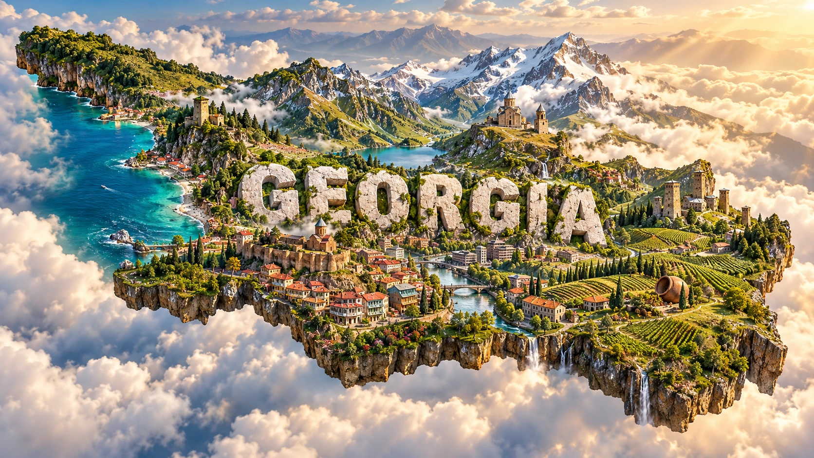
Georgia is a South Caucasus country where high folded mountains, a humid Black Sea coast, river valleys and semi-dry eastern lowlands meet within a relatively small area. The Greater Caucasus rises along the north, while the Lesser Caucasus and volcanic uplands shape the south. Between them, river corridors connect the Black and Caspian drainage basins.
This varied geography helps explain Georgia's glaciers, forests, vineyards, settlement patterns and architecture. It also places the country at a long-standing crossroads among Europe, West Asia and the wider Black Sea region. Georgia is not simply mountains and monasteries: it includes major cities, subtropical wetlands, industrial valleys and culturally diverse communities.
1. Where Is Georgia?
Georgia lies in the South Caucasus, between the Black Sea and the Caspian Sea region. It borders Russia to the north, Azerbaijan to the east and southeast, Armenia to the south, and Türkiye to the southwest. Its western coast faces the Black Sea.
Whether Georgia is described as European, Asian or transcontinental depends on the geographic convention used for the Europe–Asia boundary. “South Caucasus” is the most precise regional description and avoids treating a debated continental line as a natural fact.
Tbilisi, the capital and largest city, lies on the Mtkvari River in the east. Batumi is a Black Sea port and the principal city of the Autonomous Republic of Adjara. Kutaisi is a major western center in the Rioni basin.
Georgia's internationally recognized territory includes Abkhazia and the Tskhinvali region/South Ossetia. The central government does not exercise effective control over those regions, which the European Union describes as occupied breakaway regions following the conflicts and 2008 Russia–Georgia war. Any map or national statistic needs to make its territorial scope clear.
2. Quick Country Facts
- Official name: Georgia
- Capital: Tbilisi
- Region: South Caucasus; Black Sea region
- Area: approximately 69,700 square kilometers within internationally recognized borders
- Population: 3,941,100 on 1 January 2026 in areas covered by Georgia's official statistics; the figure excludes occupied territories
- Currency: Georgian lari (GEL)
- Official language: Georgian; Abkhaz also has official status in the Autonomous Republic of Abkhazia under Georgia's Constitution
- Time zone: Georgia Standard Time, UTC+4 throughout the year
- Highest point: Shkhara, approximately 5,200 meters, in the Greater Caucasus
- Major rivers: Mtkvari, Rioni, Enguri and Alazani
- Coast: Black Sea
- Independence restored: 9 April 1991, after the Soviet period
Population estimates differ between sources because of census revisions, migration assumptions and territorial coverage. This article uses the latest Geostat total available in September 2026 and states its scope.
3. Geography and Landscape
The Greater Caucasus forms a high northern wall with jagged peaks, glaciers and deep valleys. Shkhara, Kazbek, Tetnuldi and Ushba rise above 4,500 meters. Passes connect isolated highland regions, but snow, avalanches and landslides can close routes.
The Lesser Caucasus and southern Georgian uplands are lower but still rugged. Volcanic plateaus, lava flows and lake basins characterize parts of Javakheti. Between the two mountain systems, lower corridors contain many cities, roads and farms.
Western Georgia opens toward the Black Sea. The Colchis Lowland around the lower Rioni is humid and historically contained extensive floodplain forest, marshes and peatlands. Mountain slopes rise quickly behind the coast, forcing moist air upward and producing heavy rain.
Eastern Georgia is generally drier. The Mtkvari flows through Tbilisi and onward into Azerbaijan, eventually joining the Kura–Aras system and reaching the Caspian Sea. The Alazani Valley between the Greater Caucasus and Gombori Range is one of Georgia's major agricultural and wine-producing regions.
Rivers west of the main watershed, including the Rioni and Enguri, drain to the Black Sea. Most eastern rivers join the Mtkvari and ultimately drain to the Caspian. Georgia therefore straddles two major sea basins.
Landscapes range from Colchic rainforest and coastal wetlands to alpine meadows, conifer forest, dry steppe and badland-like terrain at Vashlovani. Vineyards occur in suitable valleys and foothills, especially in Kakheti, rather than covering the entire country.
4. Why Does Georgia Look Like This?
Georgia lies within the broad collision zone between the Arabian and Eurasian plates. As Arabia moved northward, crust and sediment between the plates were compressed, folded, faulted and uplifted. The Greater Caucasus continues to absorb much of this shortening, which is why the region remains tectonically active and experiences earthquakes.
Uplift alone did not create today's sharp relief. Rivers cut down as mountains rose, excavating deep gorges. Freeze-thaw weathering, rockfalls and landslides widened slopes. During colder periods, glaciers flowed farther down valleys, carving cirques and U-shaped troughs and leaving moraines.
In southern Georgia, past volcanism added lava and ash to the compressional landscape. Volcanic plateaus and cones are not evidence that every Georgian mountain is volcanic; the high Greater Caucasus is primarily a folded and faulted mountain belt.
The Black Sea strongly affects western landscapes. Moist air rises over mountains, cools and releases rain. Rivers carry sediment onto the Colchis Lowland, while poor drainage and a high water table encourage wetlands and peat formation. East of mountain barriers, descending air is drier, helping create steppe and semi-arid environments.
This west–east contrast explains how extremely humid forest and dry scrub can exist only a few hundred kilometers apart. Elevation adds another gradient, from subtropical lowland vegetation to permanent snow and ice.
5. Climate
Western lowlands have a humid subtropical climate influenced by the Black Sea. Winters are generally mild near the coast, summers are warm and rainfall occurs throughout the year. Adjara and windward mountain slopes receive especially high precipitation.
Eastern lowlands are more continental and drier, with hotter summers, colder winters and stronger seasonal temperature differences. The Mtkvari basin includes semi-arid areas where irrigation is important for some crops.
Mountain climate changes rapidly with elevation and exposure. Valleys can be relatively sheltered while nearby high ridges remain snowy for much of the year. Glaciers persist in the Greater Caucasus, although many are retreating as temperatures rise.
The Greater and Lesser Caucasus redirect air masses and create rain shadows. A weather forecast for Batumi therefore cannot describe conditions in Tbilisi, Kakheti, Svaneti or Javakheti.
Climate change is increasing heat stress and altering snow, glacier melt, heavy rainfall and drought risk. Glacial retreat can initially change seasonal runoff and increase hazards from unstable slopes or glacial lakes. Floods, landslides, hail and drought affect settlements, roads, hydropower and agriculture differently across regions.
6. Wildlife and Ecosystems
Georgia lies within the Caucasus biodiversity hotspot. Its steep elevation gradients and position between biogeographic regions create habitats for many endemic and range-restricted species.
Brown bears, gray wolves, Eurasian lynx, roe deer and wild boar inhabit suitable forests and mountain landscapes, but none is evenly distributed. The East Caucasian tur occupies high rocky terrain in the eastern Greater Caucasus, while West Caucasian tur occurs farther west. Chamois also use alpine and subalpine habitats.
The Caucasian leopard is extremely rare. Camera evidence has occasionally documented individuals in eastern protected areas, but it would be misleading to describe leopards as widespread or readily seen. Habitat connectivity and protection from poaching are important for any recovery.
Birds include Caucasian black grouse, Caucasian snowcock, bearded vultures and many migrants. The eastern Black Sea coast forms part of a major migration corridor used by large numbers of raptors and other birds.
The Colchic Rainforests and Wetlands World Heritage property protects ancient deciduous forest, peat-forming mires and an elevational sequence from near sea level to above 2,500 meters. Eastern protected areas such as Vashlovani conserve dry forest, steppe, cliffs and badlands, showing that Georgian biodiversity is not only alpine.
Protected areas reduce some pressures, but roads, poorly planned development, logging, grazing, poaching, invasive species and climate change cross park boundaries. Large mammals need connected habitat rather than isolated scenic sites.
7. Famous Landmarks and Natural Features
Historical Monuments of Mtskheta include Jvari Monastery and Svetitskhoveli Cathedral in Georgia's ancient capital near the meeting of the Mtkvari and Aragvi rivers. Their architecture documents the development of medieval Georgian ecclesiastical building and the country's long Christian history.
Upper Svaneti combines high Caucasus scenery with villages containing medieval defensive and residential towers. The towers are connected to Svan history, kinship and periods of insecurity; they are not a generic house type for every Georgian region.
Gelati Monastery, founded in the early twelfth century near Kutaisi, was a major religious, educational and cultural center of medieval Georgia. Conservation work remains important because moisture and previous interventions have affected its fabric.
The Colchic Rainforests and Wetlands are Georgia's natural World Heritage property. Seven components protect rainforests, bogs and other wetlands along the extremely humid eastern Black Sea region.
Gergeti Trinity Church stands above Stepantsminda beneath Mount Kazbek. Its dramatic mountain setting inspired the visual's “Kazbegi-style” church, but the artwork does not reproduce its exact location or scale.
Tbilisi's historic districts include balconies, courtyards, bathhouses, churches, mosques, a synagogue and buildings from several periods. The sulfur springs around Abanotubani are linked to the city's name and settlement history, while the modern capital extends far beyond its old town.
Vardzia is a rock-cut monastic complex developed mainly in the twelfth and thirteenth centuries in southern Georgia. Earthquakes and erosion exposed parts of its chambers, making geology part of how the monument appears today.
8. People, Languages and Culture
Georgian is the state language and belongs to the Kartvelian language family, together with Mingrelian, Laz and Svan. Modern Georgian is normally written in Mkhedruli script. UNESCO recognizes the living culture of three Georgian writing systems: Mrgvlovani, Nuskhuri and Mkhedruli.
Georgia's citizens include ethnic Georgians as well as Azerbaijani, Armenian, Russian, Ossetian, Abkhaz, Kist, Yazidi and other communities. Languages and religious traditions vary by region and family. Cultural diversity should not be hidden behind a single mountain-village image.
The Georgian Orthodox Church has had a major historical and contemporary role, but Georgia also contains Muslim, Armenian Apostolic, Catholic, Jewish and other communities. Adjara, Kvemo Kartli, Samtskhe-Javakheti and Tbilisi illustrate different patterns of language and belief.
Georgian polyphonic singing uses multiple vocal lines, with distinct regional styles in Svaneti, Kakheti and western Georgia. UNESCO lists it as intangible heritage. It is a varied living practice rather than one standardized national song.
Traditional qvevri winemaking ferments and stores wine in large egg-shaped earthenware vessels, usually buried in the ground. The practice is found across Georgia but varies among households and wine regions. Archaeological evidence shows deep viticultural history in the South Caucasus, though modern claims about a single “birthplace of wine” require careful definitions.
Georgia's history includes ancient Colchian and Iberian kingdoms, adoption of Christianity in late antiquity, powerful medieval kingdoms and centuries of Persian, Ottoman and Russian pressure. The Russian Empire annexed eastern Georgian kingdoms in the early nineteenth century. Georgia briefly became independent in 1918, was incorporated into the Soviet Union, and restored independence in 1991. Conflicts in Abkhazia and South Ossetia, displacement and the 2008 war continue to affect people and politics.
9. Food
Georgian cuisine differs by region but commonly uses bread, cheese, beans, walnuts, herbs, vegetables and meat. Walnuts thicken and flavor sauces such as satsivi, while herbs and spices vary with season and place.
Khachapuri is cheese-filled bread with many regional forms. Adjarian khachapuri is boat-shaped and often topped with egg and butter, while Imeretian and Mingrelian forms differ. One version should not stand for every region.
Khinkali are pleated dumplings associated especially with mountain areas and now eaten widely. Fillings may include seasoned meat, mushrooms, potato or cheese. Lobio is a family of bean dishes, often served with maize bread or pickles.
Churchkhela is made by threading nuts and coating them repeatedly in thickened grape juice. The supra, or feast, involves shared dishes, toasts and a toast leader called a tamada, but formality and practice vary by occasion and household.
10. Economy and Major Industries
Services dominate Georgia's economy. Trade, transport, finance, real estate, education, information and communication, hospitality and public services are important. Georgia's location between the Black Sea, Caucasus and neighboring markets supports transit corridors, ports, pipelines and logistics.
Tourism and international travel receipts support jobs and foreign exchange but are sensitive to regional conflict, politics and global disruption. Tbilisi, Batumi, mountain destinations and wine regions serve different visitor markets.
Manufacturing includes food and beverages, mineral products, metals, chemicals and machinery. Hydropower supplies much of domestic electricity generation in many years, but output varies with water conditions and new projects can affect rivers and communities.
Agriculture includes grapes, hazelnuts, citrus fruit, vegetables, cereals and livestock. Kakheti is the largest wine region, while humid western areas support hazelnuts, tea and subtropical crops. Small and fragmented farms face productivity, irrigation and climate challenges.
The World Bank recorded 7.5% real GDP growth in 2025, led especially by consumption, information and communication, education and trade. This is current context, not a permanent rate. Unemployment, regional inequality, emigration, political uncertainty and exposure to external shocks remain important challenges.
11. What the 3D Visual Represents
The Georgia artwork combines Greater Caucasus peaks, a Kazbegi-inspired mountain church, a Tbilisi-inspired old town, vineyards, green valleys and Svan-style stone towers. The peaks represent the northern mountain belt; vineyards evoke selected valleys such as Kakheti; towers refer particularly to Svaneti; and urban architecture refers to the capital.
These elements belong to widely separated places and climates. Gergeti Trinity Church does not stand beside Tbilisi's old town or Upper Svaneti towers, and vineyards do not cover alpine slopes. The visual emphasizes heritage landscapes while omitting Black Sea wetlands, dry eastern ecosystems and most modern urban infrastructure.
The outline represents Georgia within its internationally recognized borders. It does not communicate the present lack of central-government control in Abkhazia and the Tskhinvali region/South Ossetia.
The image is a conceptual artistic composition. The landmarks, architecture and landscapes are combined for educational visualization and are not shown at their true geographic positions or scale. It is not a satellite map or a statement that every cultural element represents every community.
12. Interesting Facts About Georgia
- Georgia drains toward both the Black Sea and the Caspian Sea system.
- The Greater Caucasus is still rising and deforming within the Arabia–Eurasia collision zone.
- Shkhara reaches roughly 5,200 meters and is the country's highest point.
- Western Georgia can be extremely humid while eastern valleys are semi-arid.
- Colchic rainforest contains lineages that survived major climatic changes over geological time.
- The Colchic World Heritage property includes unusual rain-fed percolation bogs.
- Upper Svaneti's towers had residential and defensive functions in specific communities.
- Georgia has four UNESCO World Heritage properties: three cultural and one natural.
- Georgian is a Kartvelian language, not a Slavic or Indo-European language.
- Three Georgian writing systems remain culturally in use, while Mkhedruli is standard in modern education.
- Qvevri are earthenware vessels buried in the ground for fermenting, ageing and storing wine.
- The Mtkvari flows through Tbilisi and continues into Azerbaijan toward the Caspian basin.
- Vardzia's present open face partly reflects earthquake damage and erosion.
- The central government does not control Abkhazia and South Ossetia despite their inclusion within Georgia's internationally recognized borders.
- The latest official population figure excludes the occupied territories, illustrating why statistical scope matters.
13. Short Quiz
-
What tectonic process helped build the Greater Caucasus? A. Separation of Arabia from Eurasia B. Collision and crustal shortening between Arabia and Eurasia C. Coral reef growth D. Antarctic glaciation
-
Why is western Georgia generally wetter than eastern Georgia? A. Moist Black Sea air rises over mountain barriers B. Eastern Georgia has no atmosphere C. Vineyards create rain D. The Caspian Sea floods it daily
-
Which heritage feature is especially associated with Upper Svaneti? A. Coral atolls B. Medieval stone towers C. Desert pyramids D. Roman aqueducts
-
What is a qvevri? A. A mountain pass B. An earthenware vessel used in winemaking C. A river ferry D. A type of glacier
-
What territorial scope does the artwork's outline represent? A. Only Tbilisi B. Georgia within its internationally recognized borders C. The entire Caucasus D. Only areas above 2,000 meters
Answer key: 1-B, 2-A, 3-B, 4-B, 5-B
14. Related Learning
Suggested internal-link opportunities:
- Armenia Explained: Highlands, Volcanoes and Ancient Culture
- Azerbaijan Explained: Caspian Coast, Mud Volcanoes and Culture
- Türkiye Explained: Plate Tectonics, Mountains and Regional Geography
- Russia Explained: Caucasus, Steppe and Continental Scale
- How the Arabia–Eurasia Collision Built the Caucasus
- Why Western Georgia Is Wetter Than Eastern Georgia
- How Glaciers Shape the Greater Caucasus
- How Qvevri Winemaking Works
- Why Svaneti Has Medieval Stone Towers
- How the Black Sea Shapes Georgia's Climate
15. Sources
- National Statistics Office of Georgia — Population , for the population on 1 January 2026 and official statistical scope
- World Bank — Georgia overview , for recent economy, population context and sector growth
- Georgia Travel — Geography of Georgia , for borders, area, mountains, climate and drainage basins
- U.S. Geological Survey — Tectonostratigraphy of the Georgian Greater Caucasus , for Arabia–Eurasia convergence, thrusting and uplift
- UNESCO World Heritage Centre — Georgia , for the current four World Heritage properties
- UNESCO — Colchic Rainforests and Wetlands , for rainforest, wetland and elevational ecosystems
- UNESCO — Upper Svaneti , for villages, towers and mountain cultural landscape
- UNESCO — Historical Monuments of Mtskheta , for Mtskheta's monuments and architectural significance
- UNESCO — Gelati Monastery , for Gelati's religious, educational and artistic importance
- UNESCO Intangible Cultural Heritage — Georgian alphabet , for the three living writing systems
- UNESCO Intangible Cultural Heritage — Georgian polyphonic singing , for regional polyphonic traditions
- UNESCO — Traditional qvevri wine-making method , for qvevri construction, fermentation and cultural transmission
- Agency of Protected Areas of Georgia — Biodiversity , for protected ecosystems and wildlife
- European External Action Service — EU and Georgia , for internationally recognized borders and the current territorial-control context