

Azerbaijan is a South Caucasus country where mountains descend toward the Kura-Aras Lowland and the western shore of the Caspian Sea. Within a relatively small area, it contains snowy summits, dry semidesert, fertile river plains, subtropical forest and one of Earth's greatest concentrations of mud volcanoes.
Its landscape reflects collision between tectonic plates, the deep sedimentary basin beneath the Caspian region and enormous differences in elevation and rainfall. Geography also explains the concentration of oil and gas, the importance of irrigation, the variety of ecosystems and the growth of Baku on the Absheron Peninsula.
1. Where Is Azerbaijan?
Azerbaijan lies in the South Caucasus, at a crossroads often described as linking Eastern Europe and Western Asia. It borders Russia to the north, Georgia to the northwest, Armenia to the west, Iran to the south and the Caspian Sea to the east.
The Nakhchivan Autonomous Republic is part of Azerbaijan but is separated from the country's main territory by Armenia. Nakhchivan borders Armenia, Iran and a short section of Turkey. This detached territory makes Azerbaijan's political geography more complex than its outline alone suggests.
Baku, the capital and largest city, stands on the Absheron Peninsula beside the Caspian. Sumgayit is an industrial city nearby. Ganja is a major western city, while Lankaran lies in the humid southeast and Sheki stands near the southern foothills of the Greater Caucasus.
The Caspian is the world's largest enclosed inland body of water. Azerbaijan therefore has a Caspian shoreline but no connection to the open ocean; it is generally classified as landlocked.
2. Quick Country Facts
- Official name: Republic of Azerbaijan
- Capital: Baku
- Region: South Caucasus
- Area: Approximately 86,600 square kilometers
- Population: 10,224,900 at the beginning of 2025, according to Azerbaijan's State Statistical Committee
- Currency: Azerbaijani manat (AZN)
- Official language: Azerbaijani; Russian, Lezgin, Talysh, Avar and other languages are also spoken
- Time zone: Azerbaijan Time (UTC+4), with no seasonal clock change
- Highest point: Bazardüzü, 4,466 meters, on the border with Russia
- Major rivers: Kura and Aras
- Largest water body: Caspian Sea
International population estimates differ slightly from the official resident count because their methods and reference dates differ. Current figures should always be dated.
3. Geography and Landscape
The Greater Caucasus rises across northern Azerbaijan. Bazardüzü and other high peaks carry seasonal or permanent snow, and steep valleys connect isolated settlements with lower foothills. The Lesser Caucasus occupies parts of the west and southwest, while the Talysh Mountains rise near Iran in the southeast.
Between these uplands lies the broad Kura-Aras Lowland. The Kura and Aras rivers collect water from a much larger international basin before joining and flowing toward the Caspian. Their plains support cities, transport routes, grazing and irrigated farming, but salinity and water scarcity limit some land.
Much of central and eastern Azerbaijan is dry steppe or semidesert. Gobustan and the Absheron Peninsula have sparse vegetation, eroded hills, salt-affected ground, mud volcanoes and petroleum-bearing rocks. Parts of the Caspian coastal lowland lie below global mean sea level because the Caspian occupies an enclosed depression.
The southeast is strikingly different. Moisture from the Caspian meets the Talysh Mountains around Lankaran, producing high rainfall and broad-leaved Hyrcanian forest. These ancient forest communities continue southward into Iran.
Nakhchivan is largely mountainous and dry. The Aras follows much of its southern boundary, and irrigation sustains farming in valleys. Because Armenia separates it from mainland Azerbaijan, people and goods use air routes or transit through neighboring states.
The Caspian's water level naturally rises and falls as river inflow, rainfall and evaporation change. It has no natural outlet to an ocean. Long-term decline now threatens ports, wetlands, fisheries and shallow coastal ecosystems, while pollution from cities, industry and hydrocarbons adds pressure.
4. Why Does Azerbaijan Look Like This?
The Caucasus belongs to a broad collision zone where the Arabian Plate moves northward against Eurasia. Compression folds and faults the crust, raises mountains and produces earthquakes. The Greater and Lesser Caucasus are not the result of one eruption or one simple fault; they developed through millions of years of deformation involving several crustal blocks.
Erosion carries rock from the mountains into valleys and the Caspian basin. Rivers deposited layers of gravel, sand, silt and clay across the Kura-Aras Lowland. In dry areas, limited rainfall and strong evaporation encourage salt to accumulate in soil, so irrigation must be managed carefully to avoid waterlogging and salinization.
Azerbaijan's mud volcanoes have a different origin from lava volcanoes. Thick, rapidly buried sediments in the South Caspian Basin contain water, fine particles and methane-rich gas under high pressure. Folds and faults provide routes upward. When the mixture reaches the surface, it can build cones, spread mud or erupt violently; flammable gas sometimes ignites.
NASA reports more than 300 mud volcanoes in eastern Azerbaijan and adjacent Caspian waters. Some offshore eruptions briefly build islands that waves and currents later erode. Counts vary with definitions and new surveys, so the educational point is Azerbaijan's exceptional concentration—not a fixed global ranking.
Natural gas seeps also help explain the country's association with fire. At Yanar Dağ, gas escaping through porous ground sustains flames. The Ateshgah temple complex on Absheron reflects the region's long religious and cultural connections to fire, although its surviving structures and uses developed across different historical periods. Neither feature means the entire landscape burns naturally.
5. Climate
Azerbaijan's climate varies greatly because elevations range from below sea level to more than 4,400 meters and mountain barriers redirect air. Low central and eastern areas generally have hot, dry summers and cool winters. Baku is dry and often windy, with the Caspian moderating temperature somewhat.
The Greater Caucasus becomes cooler and wetter with elevation. High slopes have short summers, long snowy winters and alpine conditions. Mountains intercept moisture but also place some interior valleys in rain shadows.
Lankaran and the Talysh foothills are warm and humid, receiving far more precipitation than Gobustan or Absheron. This supports tea, citrus and moisture-loving forest in suitable areas. Nakhchivan has a more strongly continental and arid climate, with hot summers, cold winters and large temperature ranges.
Climate change is intensifying heat and evaporation and increasing pressure on water, farming and ecosystems. Much of Azerbaijan's river water originates beyond its borders, making international basin management important. Declining Caspian levels, drought, floods, landslides and changing snowmelt present different risks in different regions.
6. Wildlife and Ecosystems
Azerbaijan contains semidesert, steppe, river wetlands, broad-leaved forest, mountain woodland, subalpine meadow and high rocky habitat. Species shown or discussed for one ecosystem should not be assumed to occur across the country.
The Greater Caucasus supports East Caucasian tur on steep slopes, along with chamois, brown bears, wolves and golden eagles in suitable areas. Tur are mountain goats adapted to rugged terrain and do not inhabit the Caspian lowlands.
Goitered gazelles live in dry plains and semidesert, including protected habitat in Shirvan National Park. Conservation and reintroduction have helped restore some populations. Wetlands along the Caspian and Kura-Aras system provide breeding or migration habitat for flamingos, pelicans, geese and many shorebirds.
The Caspian seal is found only in the Caspian Sea and is endangered. Its population has declined under pressures including historical hunting, accidental capture in fishing gear, pollution, disease, habitat change and loss of winter ice in the northern Caspian. It is a shared regional species, not uniquely Azerbaijani.
Hirkan National Park protects Azerbaijani components of the UNESCO-listed Hyrcanian Forests. These ancient temperate forests contain ironwood, chestnut-leaved oak and other relict plants. Leopards, wolves and brown bears occur within the wider Hyrcanian ecosystem, but leopards are extremely rare and should never be presented as common.
Other protected areas include Shahdag National Park in the Greater Caucasus, Shirvan's semidesert and gazelle habitat, and Ag-Gol National Park's wetlands. Habitat fragmentation, illegal hunting, overgrazing, water diversion, pollution, fire and climate change remain major pressures.
7. Famous Landmarks and Natural Features
Baku's Walled City, or Icherisheher, preserves defensive walls, narrow streets, the Maiden Tower and the Palace of the Shirvanshahs. UNESCO describes layers of Zoroastrian, Sasanian, Arabic, Persian, Shirvani, Ottoman and Russian influence. Modern towers and oil-era architecture beyond the walls show later stages of the capital's growth.
Gobustan Rock Art Cultural Landscape contains thousands of engravings documenting hunting, animals, boats and human life over a long period. UNESCO notes that some images preserve evidence of environments that were warmer and wetter than today's dry landscape. Nearby mud volcanoes are related geologically but are not the reason the rock art is World Heritage-listed.
The Historic Centre of Sheki and the Khan's Palace developed beside routes crossing the Caucasus. Its houses, gardens and palace reflect wealth from silkworm cultivation and silk trade, with Safavid, Qajar and Russian architectural influences.
Khinalig and the Köç Yolu transhumance route form a UNESCO cultural landscape linking a high-mountain village with seasonal livestock migration. Transhumance means moving herds between seasonal pastures; it is a continuing land-use system rather than simply a scenic trail.
The Hyrcanian Forests are a transnational natural World Heritage property shared with Iran. Their broad-leaved ecosystems survived major climatic changes and preserve rare and locally distinctive species.
Yanar Dağ and Ateshgah explain aspects of Absheron's fire symbolism, while the region's mud volcano fields reveal pressurized sediment and gas. These sites should be understood through geology and history, not described as supernatural or as ordinary magma volcanoes.
8. People, Languages and Culture
Azerbaijani, also called Azeri, is a Turkic language closely related to Turkish. It is written officially in a Latin-based alphabet. Russian remains widely understood in some urban and educational settings, while Lezgin, Talysh, Avar, Tsakhur, Tat, Udi and other languages reflect regional diversity.
Most citizens are ethnically Azerbaijani, with Lezgins, Talysh, Russians, Avars and other minorities. The population is predominantly Muslim, including both Shia and Sunni traditions, but the state is constitutionally secular. Jewish and Christian communities also have long histories in the country. Religious practice varies widely among individuals.
Mugham is a complex musical tradition involving modal systems, improvisation, poetry and highly trained performers. The tar, kamancha and frame drum often accompany a singer, although performance forms vary. UNESCO recognizes Azerbaijani mugham as intangible cultural heritage.
Azerbaijani carpet weaving has regional schools distinguished by materials, colors and motifs. Carpets can serve practical, ceremonial and artistic purposes. Treating every pattern as one national code would overlook local craft histories and the wider exchange of weaving traditions across the Caucasus and neighboring regions.
Novruz marks spring and is celebrated across a broad region from the Balkans and Caucasus through Central and South Asia. In Azerbaijan, preparations may include sprouted wheat, sweets, fire rituals and family gatherings. It is shared heritage, not exclusive to one country.
The territory has been shaped by Caucasian Albania, Persian empires and dynasties, Arab rule, Turkic migrations, local khanates and Russian imperial expansion. An independent Azerbaijan Democratic Republic existed from 1918 to 1920 before Soviet rule. The modern republic restored independence in 1991.
Conflict between Armenia and Azerbaijan over Nagorno-Karabakh produced war, displacement and closed borders after the Soviet Union collapsed, with renewed war in 2020. Azerbaijan established full control over the region in September 2023; more than 100,000 ethnic Armenians then fled to Armenia, according to UNHCR. This recent history should be distinguished from the country's diverse, centuries-old cultures and described with care for affected civilians.
9. Food
Azerbaijani cuisines combine local environments with traditions shared across the Caucasus, Iran, Anatolia and Central Asia. Plov pairs seasoned rice with meat, dried fruit, chestnuts, herbs or other additions in many regional forms. Dolma uses grape leaves or vegetables filled with meat, rice and herbs.
Qutab is a thin folded flatbread filled with greens, pumpkin, meat or cheese. Dushbara are small dumplings served in broth, while piti is a slow-cooked meat and chickpea dish associated especially with Sheki. Bread, yogurt, fresh herbs and tea are common elements of hospitality.
Pomegranates grow in several regions and carry culinary and symbolic importance. Nar Bayrami, an annual pomegranate celebration in Göyçay, is UNESCO-recognized living heritage. Saffron is associated with Absheron, and tea culture is especially prominent in the south. Recipes differ among regions and households.
10. Economy and Major Industries
Oil and natural gas have shaped Azerbaijan's modern economy more than any other resources. Baku became an early global oil center in the 19th century, and offshore Caspian fields later supported exports through pipelines toward Georgia, Turkey and European markets. Hydrocarbons provide major export and government revenue but expose the economy to changing production, prices and global energy transition.
The government is seeking greater diversification. Non-oil activities include construction, transport and logistics, retail, finance, telecommunications, tourism, food processing, chemicals and metals. Azerbaijan's position between the Caspian and Black Sea regions gives railways, ports and road corridors strategic economic importance.
Agriculture employs a substantial share of workers despite producing a much smaller share of total value. Farmers grow wheat, cotton, grapes, pomegranates, hazelnuts, vegetables, tea and other crops and raise livestock. Irrigation is essential across much of the lowland, making water efficiency and soil salinity important.
Electricity has traditionally depended heavily on natural gas, with hydropower and rapidly expanding solar and wind projects also contributing. The Caspian coast has strong wind resources. Renewable construction does not remove the need to assess land, transmission and ecosystem impacts.
The World Bank classifies Azerbaijan as upper-middle income and reported growth slowing to 1.4 percent in 2025. The Bank identifies continued dependence on hydrocarbons, a large state role, productivity constraints and geopolitical risks as long-term challenges. Such figures are dated indicators rather than permanent facts.
11. What the 3D Visual Represents
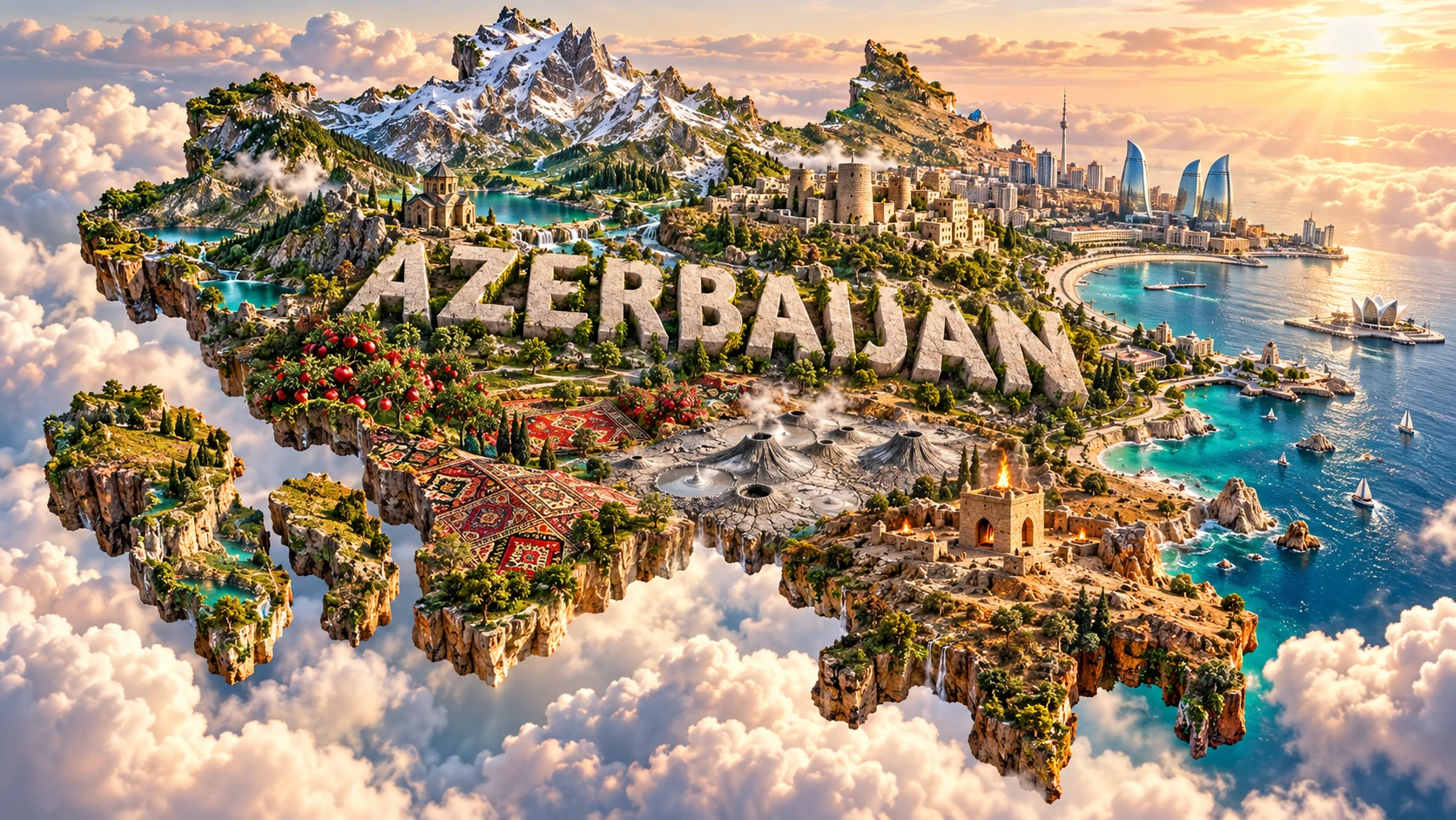
The Azerbaijan artwork combines Caucasus peaks, the Caspian coast, a Baku-inspired old city and modern skyline, mud volcanoes, fire-temple motifs, pomegranate orchards and carpet patterns. The floating outline and monumental “AZERBAIJAN” lettering compress geology, agriculture, architecture and craft into one scene.
The features belong to different regions and histories. High Caucasus terrain lies mainly in the north and west; Baku, fire sites and many mud volcanoes cluster around dry eastern Azerbaijan; pomegranate farming occurs in suitable lowlands; and carpet traditions have multiple regional schools. Fire represents gas seeps and cultural symbolism, not flames covering the country.
The image is a conceptual artistic composition. The landmarks, wildlife and landscapes are combined for educational visualization and are not shown at their true geographic positions or scale. It is not a satellite map, geological survey or exact cityscape.
12. Interesting Facts About Azerbaijan
- Azerbaijan has a Caspian shoreline but no route to the open ocean.
- Nakhchivan is separated from mainland Azerbaijan by Armenia.
- Bazardüzü is the highest point at 4,466 meters.
- Parts of the Caspian lowland lie below global mean sea level.
- The Kura and Aras form the country's most important river system.
- Tectonic collision helped raise the Greater and Lesser Caucasus.
- Mud volcanoes expel pressurized sediment, water and gas—not molten rock.
- NASA reports more than 300 mud volcanoes in eastern Azerbaijan and adjacent Caspian waters.
- Some offshore mud eruptions create temporary islands that waves later erode.
- The humid Hyrcanian forests contrast sharply with dry Gobustan and Absheron.
- The Caspian seal occurs nowhere outside the Caspian Sea.
- Gobustan's rock art records wildlife and environments different from those seen there today.
- Sheki's historic prosperity was closely linked to silk production and trade.
- Mugham combines musical modes, improvisation and poetry.
- The Caspian's level depends on river inflow, rainfall and evaporation because it has no ocean outlet.
13. Short Quiz
-
Why does Azerbaijan have many mud volcanoes? A. Pressurized mud, water and gas rise through folds and faults B. Coral reefs erupt C. Glaciers melt into magma D. Ocean tides build cones
-
Which rivers form Azerbaijan's main lowland river system? A. Rhine and Elbe B. Kura and Aras C. Nile and Blue Nile D. Ganges and Brahmaputra
-
Where are Azerbaijan's humid Hyrcanian forests? A. In the southeast near the Talysh Mountains B. Across every dry central plain C. Only in Baku D. In the Caspian's open water
-
What makes the Caspian seal geographically unusual? A. It lives only in the Caspian Sea B. It lives on every ocean coast C. It is a mountain goat D. It occurs only in forests
-
How should the 3D artwork be interpreted? A. As an exact geographic map B. As a single real landscape C. As a conceptual combination of distant features D. As a mud-volcano hazard map
Answer key: 1-A, 2-B, 3-A, 4-A, 5-C.
14. Related Learning
Suggested internal-link topics:
- Armenia Explained: Highlands, Lake Sevan and Ancient Monasteries
- Georgia Explained: Caucasus Mountains, Wine and Black Sea Landscapes
- Iran Explained: Plateaus, Deserts, Mountains and Ancient Cities
- Russia Explained: Landscapes Across Europe and Asia
- How the Caucasus Mountains Formed
- Why Azerbaijan Has So Many Mud Volcanoes
- Why the Caspian Sea Is Actually an Inland Lake
- How Natural Gas Creates Azerbaijan's Fire Phenomena
- Why the Caspian Sea's Water Level Changes
- How the Hyrcanian Forests Survived Ancient Climate Change
15. Sources
- Azerbaijan State Statistical Committee — Azerbaijan in Figures 2025
- United Nations Data — Azerbaijan country profile
- World Bank — Azerbaijan overview
- FAO AQUASTAT — Azerbaijan geography, climate and water
- FAO — Azerbaijan forest genetic resources
- NASA Earth Observatory — Azerbaijan's temporary mud-volcano island
- Azerbaijan National Academy of Sciences — Department of Mud Volcanism
- UNESCO — World Heritage properties in Azerbaijan
- UNESCO — Gobustan Rock Art Cultural Landscape
- UNESCO — Walled City of Baku
- UNESCO — Hyrcanian Forests
- UNESCO Intangible Cultural Heritage — Nar Bayrami
- UNESCO Intangible Cultural Heritage — Azerbaijani Mugham
- UNESCO Intangible Cultural Heritage — Azerbaijani carpet weaving
- UNHCR — Armenia refugee response following September 2023