

Gabon is an equatorial Central African country where vast rainforest, an Atlantic coastline and the Ogooué River system meet. Its forests form part of the Congo Basin and support globally important populations of forest elephants and great apes. Yet Gabon is not one unbroken jungle: it also contains ancient savannas, coastal lagoons, mangroves, plateaus, rapids and waterfalls.
Most Gabonese people live in towns and cities, especially around Libreville and Port-Gentil. Low population density outside major centers has helped leave extensive forest standing, although logging, mining, roads, hunting and climate change create pressure. Geography therefore links conservation with livelihoods and an economy long dependent on oil, manganese and timber.
1. Where Is Gabon?
Gabon lies on the Atlantic coast of Central Africa and is crossed by the Equator. It borders Equatorial Guinea to the northwest, Cameroon to the north and the Republic of the Congo to the east and south. The Gulf of Guinea lies to the west.
The coast extends from estuaries and mangroves near the north to lagoons, sandy barriers and forest-backed beaches farther south. Libreville, the capital and largest city, stands on the Komo estuary in the northwest. Port-Gentil, the principal oil and commercial port, occupies Mandji Island near the Ogooué delta.
Gabon is coastal, not landlocked. Its Atlantic position influences rainfall, fisheries and offshore petroleum, while the Ogooué and its tributaries connect much of the interior. Roads and settlements remain sparse in large forest areas.
2. Quick Country Facts
- Official name: Gabonese Republic
- Capital: Libreville
- Region: Central Africa; Atlantic coast
- Area: approximately 267,667 square kilometers
- Population: approximately 2,593,130 in 2025, according to the World Bank
- Currency: Central African CFA franc (XAF), shared within CEMAC and issued by the regional central bank
- Official language: French
- Major national languages: include Fang, Myene, Punu, Nzebi and many other Bantu languages
- Time zone: West Africa Time, UTC+1 throughout the year
- Major river: Ogooué River
- Highest point: commonly identified as Mont Bengoué, about 1,070 meters; published national elevation references are not fully consistent
- Coast: Gulf of Guinea, Atlantic Ocean
- Independence: 17 August 1960, from France
Gabon began its Fifth Republic after a 2023 military takeover was followed by a new constitution, a presidential election in April 2025 and further elections later that year. Political arrangements can change and should be checked again before publication.
3. Geography and Landscape
A low coastal plain borders much of the Atlantic. In the north, the Komo estuary opens beside Libreville. Farther south, the Ogooué divides into channels before reaching the sea near Port-Gentil. Long sand barriers enclose lagoons, including Fernan Vaz and Iguéla, while mangroves grow in sheltered brackish water.
The land rises inland into hills and plateaus. The Monts de Cristal, or Crystal Mountains, stand east of the northern coast and receive very heavy rainfall. The Chaillu Massif occupies part of the south-central interior. To the southeast, the Batéké Plateaux extend toward the Republic of the Congo and contain more open savanna landscapes on sandy soils.
The Ogooué is Gabon's dominant river. It enters from the Republic of the Congo, curves through the interior and drains most of the country before reaching the Atlantic. Tributaries include the Ivindo, Ngounié, Okano, Offoué and Sébé. Rapids and waterfalls interrupt many rivers, limiting continuous navigation but creating habitats and hydropower potential.
Ivindo National Park contains blackwater rivers, rapids and major falls such as Kongou and Mingouli. “Blackwater” does not mean polluted water: dissolved organic material from vegetation can darken rivers like tea.
Rainforest covers roughly nine-tenths of Gabon's land according to widely used international estimates. The forest is not uniform. Coastal forest, swamp forest, old lowland forest and upland formations differ in soils, flooding and species. Lopé contains a striking mosaic of rainforest and relict savanna, while the coast includes beaches where forest can grow unusually close to the ocean.
4. Why Does Gabon Look Like This?
Much of Gabon rests on ancient rocks associated with the Congo Craton and surrounding Precambrian geological belts. Over immense periods, uplift and erosion lowered old mountain systems into rounded massifs and plateaus. Warm, wet conditions chemically weathered exposed rock deeply, producing iron- and aluminum-rich tropical soils in many places.
Rivers cut through these uplands toward the Atlantic. Where resistant rock crosses a river's path, rapids and waterfalls form. The Ivindo's falls therefore reflect both strong river flow and differences in bedrock rather than a recent glacial landscape.
The Ogooué transports water and sediment across most of Gabon. Near the coast, its gradient decreases and the river splits into distributaries. Waves, currents and river sediment together built barrier beaches, lagoons, estuaries and delta wetlands. These landforms continue to move; a beach or channel is not a permanent boundary.
Gabon straddles the Equator, but rainfall also responds to the seasonal movement of tropical rain belts and Atlantic sea-surface conditions. During past cooler and drier periods, savanna expanded. Forest later returned, leaving patches of open grassland such as those at Lopé. UNESCO describes this forest–savanna boundary as evidence of ecological responses over about 15,000 years.
The deepest offshore basins accumulated organic-rich sediment over geological time. Heat and pressure transformed some buried organic matter into petroleum, explaining why oil fields occur along Gabon's Atlantic margin. That geological inheritance has profoundly affected the modern economy.
5. Climate
Gabon has a hot, humid tropical climate. Temperatures vary less across the year than in temperate regions, but rainfall changes strongly by season and place. Coastal and northern areas are generally very wet, and mountain slopes can enhance rain as moist air rises and cools.
Much of the country experiences a long wet season from roughly October to May, often with a shorter relative lull around December or January. The main dry season usually extends from June into September. Exact timing and intensity vary across Gabon, so these are broad patterns rather than a single national calendar.
The dry season is surprisingly cool and cloudy along parts of the coast. The cold Benguela Current and seasonal upwelling in the southeast Atlantic help stabilize the lower atmosphere and reduce rainfall even though humidity remains high. Inland areas can have larger daily temperature ranges.
Heavy rain can flood low-lying urban districts and river valleys, erode roads and trigger slope failures. Climate change may alter rainfall extremes, coastal erosion and ecosystem patterns. Sea-level rise threatens low coasts and estuaries, while warmer oceans and changing currents affect marine life.
6. Wildlife and Ecosystems
Gabon is a major refuge for the African forest elephant, a species distinct from the larger African savanna elephant. Forest elephants move through dense vegetation, disperse large seeds and help shape forest structure. IUCN's 2025 regional assessment estimated that Gabon held about two-thirds of the global forest-elephant population, but poaching, habitat fragmentation and conflict around crops remain serious threats.
Western lowland gorillas and central chimpanzees inhabit suitable forests. They do not normally stand in open groups beside roads or cities as an illustration might imply. Great apes reproduce slowly and are vulnerable to hunting, habitat disturbance and diseases such as Ebola.
Mandrills live in forests and forest–savanna mosaics, especially in western Central Africa. Lopé is famous for exceptionally large seasonal mandrill gatherings, but the species is not equally visible across Gabon. Other mammals include forest buffalo, sitatunga, red river hogs, leopards and several monkey species.
Coastal ecosystems add sea turtles, dolphins and whales. Humpback whales migrate from Southern Ocean feeding grounds to tropical waters off Gabon and neighboring coasts to breed during the Southern Hemisphere winter. Their presence is seasonal, and whales do not inhabit inland rivers or every stretch of coast.
Gabon created 13 national parks in 2002, protecting a range of forest, savanna, river and marine-connected environments. Protected status alone cannot prevent every threat. Effective conservation requires enforcement, monitoring, cooperation with neighboring countries and meaningful involvement of communities whose livelihoods and histories are tied to these lands.
7. Famous Landmarks and Natural Features
Ivindo National Park is a UNESCO natural World Heritage property. Its intact interior forests surround the Ivindo and Djidji river systems, blackwater reaches, rapids and waterfalls. UNESCO recognizes both its ecological processes and refuge for rare and threatened species.
The Ecosystem and Relict Cultural Landscape of Lopé-Okanda is Gabon's other World Heritage property and is listed for both natural and cultural importance. Forest and old savanna meet there, while archaeological sites, iron-working evidence and about 1,800 recorded rock carvings document a long history of human movement and settlement along the Ogooué corridor.
Loango National Park protects a coastal mosaic of lagoons, beaches, savannas, mangroves and forest. Forest elephants and buffalo sometimes reach beaches, but such sightings are localized rather than an everyday picture of Gabon's entire shore. The park is on Gabon's UNESCO Tentative List, not the inscribed World Heritage List.
Pongara National Park, across the estuary from Libreville, protects mangroves, forest and beaches used by nesting leatherback turtles. Artificial light, disturbance, fishing gear and coastal change can threaten turtles.
The Kongou and Mingouli falls on the Ivindo are broad systems of cascades and channels rather than a single narrow drop. They illustrate how resistant rock and a high-volume tropical river interact.
In Libreville, the National Museum of Arts, Rites and Traditions of Gabon interprets cultural objects and living traditions. Cultural heritage should not be treated as decoration detached from the communities that created and continue it.
8. People, Languages and Culture
French is the official language and is widely used in government, education and cities. Gabon is also multilingual. Fang, Myene varieties, Punu, Nzebi, Teke and many other languages belong mainly to the Bantu branch of the Niger-Congo family. Individuals and families may use different languages depending on home, school, work or region.
The population includes many communities with distinct histories rather than one single “Gabonese tribe.” Indigenous forest peoples, including Babongo and other communities identified by different local names, hold detailed ecological knowledge but have also faced discrimination and unequal access to services and land rights. Terminology should follow how communities identify themselves.
Masks, carved figures, dance, drumming and oral arts have important roles in particular communities and ceremonies. Fang ngil masks and Punu white-faced mukudj masks are well known internationally, but they belong to specific historical and ritual contexts and do not represent every Gabonese person.
Bwiti is a religious and initiatory tradition practiced in several forms by some communities. Music, dance, teaching and the ritual use of iboga may be involved. It coexists with Christianity, Islam and other belief systems and should not be generalized to the whole population or reduced to one plant.
Gabon was incorporated into French Equatorial Africa during colonial rule, which brought forced labor, extraction and major political change. It became independent in 1960. Oil later funded infrastructure and urban growth without producing equal opportunity. A 2023 military takeover ended decades of Bongo-family rule, and elections formally concluded the transition in 2025.
Contemporary culture includes urban popular music, hip-hop, gospel, literature, film, fashion and digital media alongside regional practices. Libreville's population also reflects migration from neighboring African countries and wider global connections.
9. Food
Cassava, plantain, taro, yams and rice are important starches. Cassava may be processed into fermented or cooked forms, while plantains can be boiled, fried or pounded. Fish is important along rivers and the coast, though access and species differ by place.
Poulet nyembwe combines chicken with a sauce made from oil-palm fruit pulp and is widely associated with Gabon. Similar palm-based dishes occur elsewhere in Central Africa, with local preparation varying. Stews may include fish, meat, leafy vegetables, groundnuts, chili or forest products.
Atanga, the fruit of Dacryodes edulis, is boiled or roasted and has a soft, rich pulp. Bushmeat has historical and livelihood roles in some communities, but hunting protected or threatened wildlife is a conservation and legal concern. Gabonese food today also reflects urban markets, imported staples and influences from neighboring countries.
10. Economy and Major Industries
Petroleum has dominated Gabon's exports and public revenue since large-scale production began in the twentieth century. Offshore fields, Port-Gentil and related services remain important, but mature fields and changing prices make dependence on oil risky.
Gabon is also a major producer of manganese, mined especially around Moanda in the southeast. Manganese is used mainly in steelmaking. Timber—particularly okoumé and processed wood—has long been another major export. Forestry provides income and jobs but must be managed to prevent habitat loss, excessive roads and unsustainable cutting.
The World Bank reported that oil, manganese and wood made up about 97% of merchandise exports in 2024. It estimated 2.5% growth in 2025, while unemployment and poverty remained high, showing that resource wealth and household well-being are not the same.
Services, construction, transport and public administration are concentrated in cities. Agriculture includes cassava, plantain, vegetables, palm oil, livestock and smallholder production, but Gabon imports much of its food. Coastal and inland fisheries contribute to diets and livelihoods.
Economic diversification efforts focus on processing timber and minerals locally, agriculture, fisheries, tourism, digital services and cleaner energy. Forest carbon storage has enormous global value, yet assigning a monetary value to it does not automatically create community income or guarantee biodiversity protection.
11. What the 3D Visual Represents
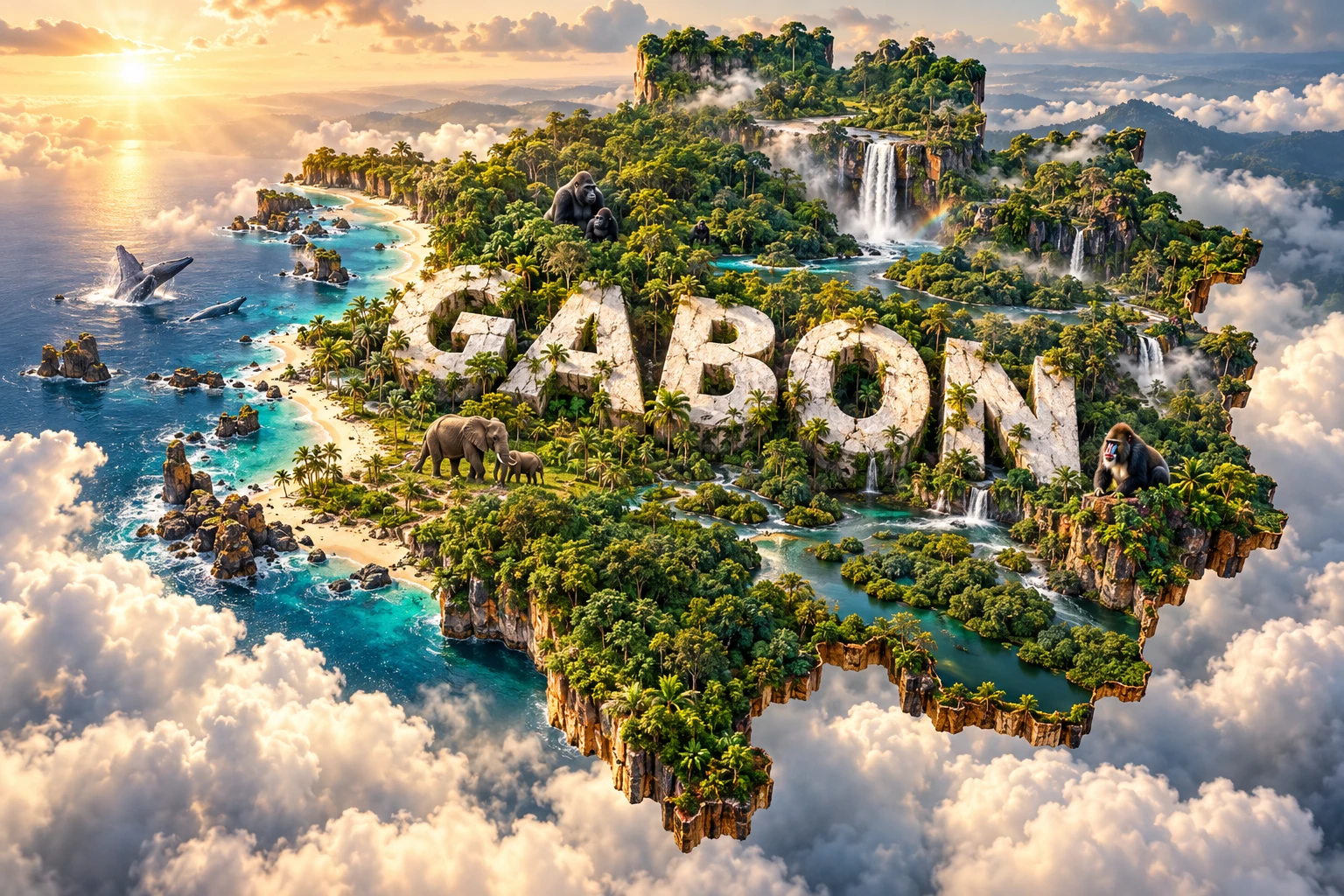
The Gabon artwork combines rainforest reaching Atlantic beaches, waterfalls, rivers, forest elephants, gorillas, mandrills and whales offshore. The forest and river elements evoke the Congo Basin, Ogooué drainage and parks such as Ivindo. Beach forest and marine life evoke protected coastal landscapes including Loango and seasonal humpback-whale waters.
Each animal represents a particular habitat and distribution. Forest elephants and western lowland gorillas use extensive forest; mandrills occur in suitable forest and mosaic habitat; humpback whales migrate offshore rather than remaining year-round. The image leaves out cities, savannas, mines and many communities, so it represents conservation themes rather than the whole country.
The image is a conceptual artistic composition. The landmarks, wildlife and landscapes are combined for educational visualization and are not shown at their true geographic positions or scale. It is not a satellite map, and an animal's inclusion does not mean it occurs everywhere in Gabon.
12. Interesting Facts About Gabon
- The Equator crosses Gabon, but seasonal Atlantic currents still produce a distinct long dry season.
- Roughly nine-tenths of Gabon's land remains forested under widely used international estimates.
- The Ogooué and its tributaries drain most of the country.
- Gabon's 13 national parks were established together in 2002.
- Ivindo National Park protects blackwater rivers, rapids, waterfalls and old interior forest.
- Lopé-Okanda is both a natural and cultural World Heritage property.
- Lopé preserves about 1,800 recorded petroglyphs as well as evidence of ancient settlements and ironworking.
- Relict savannas at Lopé record environmental change and long interaction between people and nature.
- Gabon is one of the world's most important remaining strongholds for critically endangered African forest elephants.
- Forest elephants help disperse seeds and can influence which trees grow in a forest.
- Humpback whales visit Gabonese waters seasonally to breed after feeding much farther south.
- The country is highly urbanized even though its average population density is low.
- Libreville stands by the Komo estuary, while Port-Gentil lies near the Ogooué delta.
- Oil, manganese and wood together account for nearly all merchandise exports.
- Gabon's coastal lagoons formed through interaction among rivers, ocean currents, waves and sediment.
13. Short Quiz
-
Which river drains most of Gabon? A. Nile B. Ogooué C. Senegal D. Zambezi
-
Why do humpback whales occur off Gabon seasonally? A. They migrate to tropical breeding waters B. They live in waterfalls C. They feed only on mangroves D. They cannot enter colder water
-
What makes Lopé-Okanda a mixed World Heritage property? A. It contains both natural ecosystems and important cultural evidence B. It is half desert and half glacier C. It belongs to two countries D. It contains only modern buildings
-
Which products dominate Gabon's merchandise exports? A. Coffee, cotton and tea B. Cars, aircraft and computers C. Oil, manganese and wood D. Wheat, wool and dairy products
-
What does the Gabon artwork represent? A. Exact animal locations and scale B. A conceptual combination of selected landscapes and wildlife C. A live satellite image D. Every city and industry
Answer key: 1-B, 2-A, 3-A, 4-C, 5-B
14. Related Learning
Suggested internal-link opportunities:
- Cameroon Explained: Rainforests, Highlands and Cultural Diversity
- Equatorial Guinea Explained: Islands, Rainforest and Gulf of Guinea Geography
- Republic of the Congo Explained: Rivers, Forests and Wildlife
- How the Congo Basin Rainforest Influences Climate
- Why Forest Elephants Are Important Seed Dispersers
- How Gabon's Ogooué River Shapes the Country
- Why Gabon Has a Long Dry Season on the Equator
- How Blackwater Rivers Form
- Why Humpback Whales Migrate to West-Central Africa
- How Forest and Savanna Meet at Lopé
15. Sources
- World Bank Data — Gabon , for 2025 population and economic indicators
- World Bank — Gabon country overview , for urbanization, political transition, forests and recent economic context
- World Bank — Gabon Economic Update 2025 , for exports, forest value, poverty and diversification context
- UNESCO World Heritage Centre — Gabon , for the current two World Heritage properties and Tentative List
- UNESCO — Ivindo National Park , for river systems, forest ecology, biodiversity and protection status
- UNESCO — Ecosystem and Relict Cultural Landscape of Lopé-Okanda , for the forest–savanna mosaic, archaeology, rock art and ecological history
- Wildlife Conservation Society Gabon — Gabon's forests , for forest extent, habitats and forest-dependent communities
- Wildlife Conservation Society Gabon — Great apes , for western lowland gorilla and central chimpanzee distribution
- Wildlife Conservation Society Gabon — Marine mammals , for humpback-whale migration and breeding waters
- IUCN — African forest elephant status update , for Gabon's share of the estimated global population and conservation status
- FAO in Gabon , for agriculture, fisheries, forest biodiversity and okoumé
- IMF — Gabon 2024 Article IV consultation , for oil dependence and macroeconomic context