

Angola is a large country on Africa's South Atlantic coast where a narrow, often dry coastal plain rises sharply to a wetter interior plateau. Its landscapes range from northern tropical forest and vast miombo woodland to central grasslands, southern mopane savanna and the Namib Desert.
Several of southern Africa's major river systems begin or gather water in the Angolan highlands. This elevated interior, together with the cold Benguela Current offshore, explains why Angola can contain misty desert, broad waterfalls, forested escarpments and seasonally flooded headwaters within one national territory.
1. Where Is Angola?
Angola lies on the western side of southern Africa. It borders the Democratic Republic of the Congo to the north and northeast, Zambia to the east, Namibia to the south and the Atlantic Ocean to the west.
The province of Cabinda is an exclave: a narrow strip of the Democratic Republic of the Congo separates it from the rest of Angola. Cabinda borders the Republic of the Congo and the Democratic Republic of the Congo and also has an Atlantic coastline.
Luanda, the capital and largest city, stands on the northwestern coast. Other important cities include Huambo and Kuito on the central plateau, Benguela and Lobito on the coast, Lubango in the southwestern highlands, Malanje in the north-central interior and Soyo near the Congo River mouth.
2. Quick Country Facts
- Official name: Republic of Angola
- Capital: Luanda
- Region: Southern and Central Africa
- Area: Approximately 1,246,700 square kilometers
- Population: 36,604,681 residents counted on 19 September 2024 in Angola's final census results
- Currency: Kwanza (AOA)
- Official language: Portuguese; Umbundu, Kimbundu, Kikongo, Chokwe, Kwanyama and other African languages are widely spoken
- Time zone: West Africa Time (UTC+1) throughout the year
- Highest point: Mount Moco, approximately 2,620 meters
- Major rivers: Kwanza, Cunene, Cubango, Cuando and tributaries of the Congo system
- Coast: South Atlantic Ocean
International population estimates can differ from the census because they use demographic models and different reference dates. Angola's 2024 census is the latest complete official count; estimates should always be labeled by source and year.
3. Geography and Landscape
Angola's coastal plain is generally narrow and low. It is broadest in some northern and southern areas but is separated from the interior by a steep escarpment. Luanda and several ports occupy this Atlantic margin, where bays, beaches, cliffs, estuaries and coastal desert replace one another from north to south.
East of the escarpment, much of Angola forms a plateau roughly 1,000 to 1,600 meters above sea level. Higher ground around Huambo, Bié and Huíla includes mountain ridges and the country's highest summit, Mount Moco. Cooler temperatures and greater rainfall distinguish these uplands from many coastal areas.
The northern interior and Cabinda contain tropical and transitional forests. Across much of central and eastern Angola, miombo woodland—open woodland dominated by trees adapted to a pronounced dry season—covers large areas. Mopane woodland, savanna and increasingly dry steppe occur toward the south.
The far southwest belongs to the northern Namib. Sand dunes, gravel plains, rocky outcrops and fog-dependent vegetation occur in Iona National Park and along the coast. Desert does not cover the whole southwest uniformly, and conditions change inland with altitude and rainfall.
Angola is an important watershed. The Kwanza rises on the plateau and flows west to the Atlantic. The Cunene runs south and then forms part of the Namibia border. The Cubango flows southeast and becomes the Okavango, eventually sustaining Botswana's inland delta. Eastern tributaries also feed the Cuando–Zambezi system, while northern rivers connect with the Congo Basin.
4. Why Does Angola Look Like This?
Much of Angola rests on very old continental crust shaped over hundreds of millions of years. The high interior plateau is an eroded surface that was uplifted and dissected, leaving steep escarpments where rivers descend toward the Atlantic.
The opening of the South Atlantic began when Africa and South America pulled apart during the Early Cretaceous. Faulting created rift basins along Angola's future coast. Rivers and seas later filled these basins with thick layers of sediment and salt. Organic material buried within some sediments eventually formed the petroleum resources now extracted offshore.
Uplift gave west-flowing rivers enough energy to cut gorges and waterfalls at changes in rock resistance or elevation. Kalandula Falls forms where the Lucala River crosses a resistant bedrock rim before descending toward the Kwanza system. Its flow and visible width change between wet and dry seasons.
The Black Rocks of Pungo Andongo are resistant conglomerate formations. Conglomerate is rock made from rounded pebbles and larger fragments cemented together. Weathering and erosion removed weaker surrounding material, leaving massive dark monoliths above the plain.
The plateau also creates continental drainage divides. Rain falling only a short distance apart may begin journeys toward the Atlantic, Congo Basin, Zambezi or the landlocked Okavango Delta. Wetlands and floodplains store and slowly release some of this water.
Along the southwest coast, the cold Benguela Current cools the air and limits evaporation from the ocean into rising rain clouds. Stable air and coastal fog can form without substantial rain, helping maintain Namib aridity even beside the Atlantic. Inland elevation and seasonal tropical air produce much wetter conditions.
5. Climate
Most of Angola has distinct wet and dry seasons. The warm rainy season generally runs from about October or November into April, while the cooler dry season—called cacimbo in many areas—extends through the middle of the year. Timing and intensity vary by location.
Rainfall is highest in much of the north and northeast and decreases toward the southwest. The central plateau receives enough seasonal rain to support rivers, crops and miombo woodland. At high elevation, nights and dry-season mornings can be cool.
The Benguela Current makes the coast cooler and drier than its tropical latitude suggests. Luanda has a long dry season, while the Namibe coast is extremely arid. Fog supplies moisture to specialized desert organisms but cannot replace dependable rainfall for most farming.
Drought is recurrent in southern Angola and can reduce crops, pasture and water supplies. Heavy wet-season rain elsewhere can cause floods, erosion and outbreaks of water-related disease. Climate change is intensifying heat and water stress and may alter rainfall timing, river flow, wildfire and flood risk.
6. Wildlife and Ecosystems
Angola lies where Central African forest, Zambezian woodland, savanna and Namib ecosystems meet. This transition creates high biological diversity, but decades of war, hunting, land mines, habitat loss and weak monitoring severely affected many wildlife populations.
The giant sable antelope is a rare subspecies found only in a restricted part of central Angola, especially Cangandala National Park and Luando Integral Nature Reserve. It is a national symbol but is not widespread. Conservation relies on habitat protection, genetic management, monitoring and control of illegal hunting and hybridization.
African elephants occur mainly in selected eastern and southeastern landscapes connected with neighboring countries. They are not evenly distributed across Angola. Giraffes, zebras, antelopes, buffalo and large predators have survived or been restored in some protected areas, while abundance differs greatly among parks.
The black-faced impala is associated with the arid southwest of Angola and neighboring Namibia. Manatees and other aquatic species inhabit suitable northern rivers and estuaries. Sea turtles use parts of the Atlantic coast, and the country's wetlands support resident and migratory birds.
Miombo and mopane woodlands provide habitat, fuel, food and watershed protection. FAO identifies agricultural expansion, unsustainable charcoal production, overgrazing and climate change as pressures on these dry forests. In the Namib, the unusual Welwitschia plant survives with extremely long-lived leaves and adaptations to aridity.
National parks include Iona in the desert southwest, Quiçama near Luanda, Bicuar in the south, Cameia in the east and Cangandala in giant sable habitat. Protected status alone does not mean historical animal numbers have recovered; conservation outcomes depend on management and local participation.
7. Famous Landmarks and Natural Features
Kalandula Falls is a broad, curved waterfall on the Lucala River in Malanje Province. The river drops roughly 105 meters across a crest about 400 meters wide, although the active curtain changes with discharge. Gallery forest near the river contrasts with surrounding miombo woodland.
The Black Rocks of Pungo Andongo are conglomerate monoliths rising abruptly from the landscape. They have geological importance and strong historical and oral associations with the Kingdom of Ndongo and Queen Njinga. Stories connected to the rocks should be identified as cultural tradition rather than tested geological evidence.
Mbanza Kongo was the political and spiritual capital of the Kingdom of Kongo. Its archaeological and built remains document an African state that encountered Portuguese traders and missionaries from the 15th century, adopted Christianity in locally shaped forms and became entangled in the Atlantic slave trade. It is Angola's first UNESCO World Heritage property.
Tundavala Gap opens from the Huíla plateau toward much lower western terrain. Its cliffs reveal the dramatic edge between highland and escarpment. Serra da Leba nearby is known for a winding engineered road descending through the mountains.
Iona National Park protects desert, steppe, dunes and mountain environments in the southwest. Coastal fog and extreme dryness support specialized plants and animals. Mount Moco is Angola's highest point and contains isolated patches of Afromontane forest important to endemic birds and other species.
Fort São Miguel in Luanda records Portuguese military and colonial history, including the systems through which enslaved Africans were sent across the Atlantic. It should be interpreted in that wider human context rather than only as decorative architecture.
8. People, Languages and Culture
Angola's population includes many communities with distinct histories and languages. Umbundu is associated especially with Ovimbundu communities of the central plateau; Kimbundu with Ambundu communities around Luanda and the north-central region; and Kikongo with Bakongo communities in the northwest. Chokwe, Kwanyama, Ngangela varieties and many other languages are also spoken.
Portuguese is the official language and the dominant language of national government, formal education and much urban communication. Angolan Portuguese has its own vocabulary, pronunciation and cultural setting. Multilingual households are common, and language use has changed through urbanization and migration.
Before colonial rule, the region contained organized states and trading networks, including the kingdoms of Kongo and Ndongo and Lunda-related polities. Portuguese contact began in the late 15th century. Warfare, Atlantic slavery and gradual colonial conquest profoundly changed societies; effective Portuguese control over the whole territory came much later than first coastal contact.
Angola became independent from Portugal on 11 November 1975. A long civil war followed among rival movements, intensified by Cold War intervention, and ended in 2002. The war displaced millions, damaged infrastructure and left land mines that still affect some communities. Modern Angola should not be defined only by this conflict.
Music and dance are central to cultural life. Semba developed through Angolan rhythmic and social traditions and influenced other Lusophone music. Kizomba emerged in late-20th-century Angola, while kuduro combines electronic production, energetic dance and urban expression. Styles differ by generation and region.
Basketry, ceramics, wood carving, textiles, storytelling and masked performance belong to particular communities and occasions. Luanda is a large, rapidly changing city whose contemporary art, fashion and literature coexist with rural and regional traditions. No single costume, dance or object represents all Angolans.
9. Food
Funge is a soft staple made from cassava or maize flour and served with sauces or stews. Cassava-based funge is especially common in some northern areas, while maize versions are important elsewhere. Preparation varies by household and region.
Moamba de galinha combines chicken with palm-oil sauce and may include okra or other ingredients. Calulu is a family of dishes using fish or meat with vegetables and greens. Mufete commonly pairs grilled fish with beans, cassava, plantain or sweet potato, especially in Luanda's coastal food culture.
Kizaca uses prepared cassava leaves, often with ground peanuts or palm oil. Beans, maize, cassava, sweet potatoes, vegetables, dried fish and tropical fruit remain important. Portuguese influence appears in bread, grilling, pastries and other dishes, but Angolan cuisine is not simply Portuguese food transplanted to Africa.
10. Economy and Major Industries
Oil dominates Angola's exports and supplies a large share of government revenue. Most production is offshore, including deep-water fields. This has funded infrastructure and public spending but also exposes the economy to oil-price changes and declining output from mature fields.
Diamonds are another major export, particularly from northeastern provinces. Mining also includes construction materials and exploration for other minerals. Resource extraction creates revenue but requires transparent management, environmental safeguards and benefits that reach communities.
Agriculture supports many livelihoods. Cassava, maize, beans, bananas, sweet potatoes, vegetables, coffee and livestock are important in different ecological zones. Angola has considerable arable potential, but roads, storage, finance, land access, drought and remaining mines constrain production.
Fishing is important along the Benguela-influenced coast, where nutrient-rich upwelling supports marine productivity. Manufacturing includes food and beverages, cement, textiles and petroleum products. Construction, commerce, telecommunications, transport, banking and public services contribute to the non-oil economy.
World Bank analysis identifies oil dependence as the central structural challenge. Oil has recently accounted for around 30 percent of GDP, 65 percent of revenue and more than 95 percent of goods exports. Diversification, education, infrastructure, reliable power, inclusive finance and productive employment are therefore linked to long-term living standards.
11. What the 3D Visual Represents
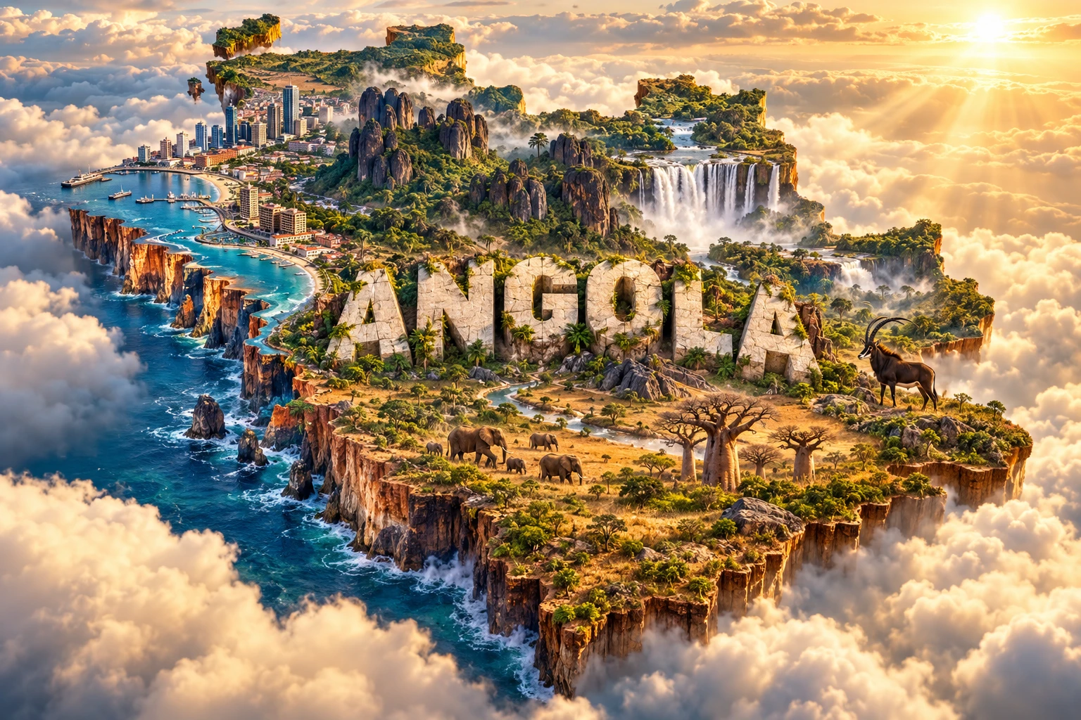
The Angola artwork combines Atlantic cliffs, tropical forest, savanna, the Black Rocks of Pungo Andongo, Kalandula Falls, Luanda-inspired architecture, giant sable antelope, elephants and baobabs. The floating outline and monumental “ANGOLA” lettering bring these distant environments into one symbolic micro-world.
The real features are widely separated. Luanda lies on a dry northwestern coast; Kalandula and Pungo Andongo are inland in Malanje Province; giant sable survive in restricted central habitat; elephants are concentrated in selected landscapes; and rainforest, miombo, desert and baobab savanna do not occupy one continuous scene.
The image is a conceptual artistic composition. The landmarks, wildlife and landscapes are combined for educational visualization and are not shown at their true geographic positions or scale. It is not a satellite map, a wildlife-range map or an exact reconstruction of any landmark.
12. Interesting Facts About Angola
- Cabinda is separated from the rest of Angola by part of the Democratic Republic of the Congo.
- Angola's official 2024 census counted 36,604,681 residents.
- The interior plateau sends rivers toward four major drainage regions: the Atlantic, Congo, Zambezi and Okavango.
- The Kwanza River gave its name to Angola's currency, the kwanza.
- Mount Moco is the country's highest point at about 2,620 meters.
- The cold Benguela Current helps make Angola's southwest coast unusually dry.
- Coastal petroleum formed in sedimentary basins associated with the opening of the South Atlantic.
- Kalandula Falls lies on the Lucala, a tributary of the Kwanza.
- Pungo Andongo's monoliths are made mainly from resistant conglomerate rock.
- Giant sable antelope are restricted to a small part of central Angola and do not roam nationwide.
- The Cubango River becomes the Okavango and helps supply Botswana's inland delta.
- Mbanza Kongo was a major African capital before Portuguese arrival.
- Portuguese is official, but Angola is home to many Bantu languages.
- The Namib extends into southwestern Angola and supports the unusual Welwitschia plant.
- Angola achieved independence in 1975, while its civil war ended in 2002.
13. Short Quiz
-
Which ocean borders Angola? A. Indian Ocean B. Atlantic Ocean C. Pacific Ocean D. Arctic Ocean
-
Why is southwestern Angola unusually dry? A. The cold Benguela Current helps suppress rainfall B. It lies inside the Arctic Circle C. Glaciers remove all moisture D. It has no nearby ocean
-
Where does the giant sable antelope survive? A. Uniformly across Angola B. In restricted central Angolan habitat C. Only in Luanda D. In the Atlantic Ocean
-
What is important about the Cubango River? A. It becomes the Okavango and feeds an inland delta B. It flows into the Mediterranean C. It begins in Europe D. It never carries water
-
How should the 3D artwork be interpreted? A. As an exact satellite map B. As one real ecosystem C. As a conceptual combination of distant features D. As a national wildlife census
Answer key: 1-B, 2-A, 3-B, 4-A, 5-C.
14. Related Learning
Suggested internal-link topics:
- Namibia Explained: Namib Desert, Coast and Wildlife
- Zambia Explained: Plateaus, Rivers and Victoria Falls
- Democratic Republic of the Congo Explained: Congo Basin and Rainforest
- How the Benguela Current Shapes Southwestern Africa
- How Angola's Highlands Feed the Okavango Delta
- Why Kalandula Falls Formed
- How the South Atlantic Ocean Opened
- Why the Giant Sable Antelope Is So Rare
- How Miombo Woodlands Support People and Wildlife
- How the Kingdom of Kongo Connected Central Africa and the Atlantic
15. Sources
- Angola National Statistics Institute — final 2024 census results
- United Nations Data — Angola country profile
- World Bank — Angola overview
- World Bank — Angola Economic Update 2025
- World Bank — Angola Country Economic Memorandum
- FAO — Angola dryland landscapes
- FAO — Angola Country Programming Framework
- UNESCO — Mbanza Kongo
- UNESCO — Angola World Heritage profile
- Key Biodiversity Areas — Kalandula
- Government of Angola tourism publication — Kalandula and Pungo Andongo
- Government of Angola — Kwanza Basin management plan