

Cambodia is a mainland Southeast Asian country whose geography is organized around water. The Mekong crosses the east, while the Tonlé Sap lake and river form a seasonal system in which the connecting river changes direction. That annual flood pulse supports wetlands, fisheries and rice-growing plains.
Mountains and forests frame this lowland center. The temples of Angkor reveal how earlier Khmer societies engineered reservoirs and canals as well as monumental architecture. Modern Cambodia is culturally diverse, rapidly urbanizing and still shaped by both the achievements of the Khmer Empire and the profound losses of twentieth-century war and genocide.
1. Where Is Cambodia?
Cambodia lies in southern mainland Southeast Asia. Thailand borders it to the west and northwest, Laos to the north, and Vietnam to the east and southeast. Its southwest coast faces the Gulf of Thailand, so Cambodia is a coastal country rather than landlocked.
The capital, Phnom Penh, stands near the meeting of the Mekong, Tonlé Sap and Bassac waterways. This river junction helped it become the country's political, commercial and transport center. Siem Reap is the main urban center near Angkor; Battambang serves the productive northwest; Sihanoukville is the principal deep-water port; and Kampong Cham, Kratie and Stung Treng are important Mekong cities.
Cambodia belongs to the Lower Mekong Basin. Its rivers connect it ecologically and economically with neighboring countries, meaning that upstream rainfall, dams, sediment and fisheries management can affect conditions far beyond national borders.
2. Quick Country Facts
- Official name: Kingdom of Cambodia
- Capital: Phnom Penh
- Region: Mainland Southeast Asia
- Area: Approximately 181,035 square kilometers
- Population: About 17.6 million in 2024, according to the World Bank
- Currency: Cambodian riel (KHR); US dollars also circulate widely
- Official language: Khmer
- Time zone: Indochina Time (UTC+7) throughout the year
- Highest point: Phnom Aural, approximately 1,813 meters
- Major rivers: Mekong, Tonlé Sap and Bassac
- Largest lake: Tonlé Sap, whose area changes greatly with the seasons
- Coast: Gulf of Thailand
Population figures are estimates between national censuses. Cambodia's 2019 census remains the most recent full population count, while international and national agencies publish later estimates and projections.
3. Geography and Landscape
Much of Cambodia is a broad, low-lying central plain around Tonlé Sap and the lower Mekong. The plain contains floodplains, wetlands, rice fields and natural levees built from river sediment. Because the land is relatively level, seasonal water can spread across large areas.
Tonlé Sap is Southeast Asia's largest freshwater lake system. In the dry season, water drains from the lake through the Tonlé Sap River toward Phnom Penh. As monsoon-fed Mekong levels rise, the pressure gradient reverses: water flows northwest into the lake, which can expand to several times its dry-season area. Flooded forest, grassland and fields become temporary aquatic habitat.
Uplands surround this basin. The Cardamom and Elephant mountains rise in the southwest, where Phnom Aural forms the country's highest point. These ranges intercept moist air from the Gulf of Thailand and contain some of mainland Southeast Asia's largest remaining forest landscapes. The Dângrêk escarpment marks part of the northern border, while northeastern plateaus extend toward Laos and Vietnam.
Cambodia's roughly 440-kilometer coastline includes estuaries, mangroves, beaches and islands. Coastal provinces face different environmental pressures from the interior, including erosion, saltwater intrusion, port development and the condition of coral and seagrass habitats.
4. Why Does Cambodia Look Like This?
Cambodia's bowl-like landscape reflects long geological development and river action. Resistant uplands ring a lower interior basin. Over time, the Mekong and its tributaries carried weathered rock downstream and deposited sediment across the central plain, producing fertile but flood-prone land.
The Asian monsoon powers the most visible annual transformation. Wet-season rain across the vast Mekong Basin raises the main river at Phnom Penh above the level of Tonlé Sap. The Tonlé Sap River then reverses toward the lake. The Mekong River Commission reports that the lake may grow to about six times its normal size during the flood season. When Mekong levels fall, the river changes direction again and the lake releases stored water.
This pulse is more than a curiosity. Floodwater carries nutrients and sediment into forests and plains; fish move into newly flooded habitat to feed and reproduce; and receding water leaves productive land. Changes in rainfall, river infrastructure and climate can alter the timing and size of the pulse, with consequences for ecosystems and livelihoods.
Mountain relief also shapes Cambodia. Moist southwest monsoon winds rise over the Cardamom and Elephant ranges, cool and produce heavy rainfall. Land farther inland can receive less rain. Tropical heat, chemical weathering and erosion round exposed hills and feed sediment back into river systems.
5. Climate
Cambodia has a tropical monsoon climate with warm conditions throughout the year. The southwest monsoon generally brings the wet season from about May to October. The northeast monsoon is associated with the drier, somewhat cooler period from roughly November to April.
March and April are commonly the hottest months before dependable monsoon rain arrives. Temperatures vary with elevation and local conditions, while humidity is high for much of the year. The southwest mountains and coastal slopes are among the wettest areas; parts of the central plain are drier.
Seasonal flooding is a normal and valuable ecological process, but severe floods can damage homes, roads and crops. Drought can also reduce rice yields and Tonlé Sap inflow. Climate change adds risks from hotter extremes, shifting rainfall, drought, intense downpours and coastal sea-level rise. These hazards interact with deforestation, wetland loss and upstream changes rather than acting alone.
6. Wildlife and Ecosystems
Cambodia contains dry dipterocarp forest, evergreen rainforest, seasonally flooded forest, freshwater wetlands, grasslands, mangroves, seagrass beds and coastal waters. Each habitat supports a different community; no single animal represents the whole country.
Asian elephants survive mainly in large forest landscapes, particularly the Cardamom region and eastern plains. They are endangered and threatened by habitat fragmentation, snares and conflict near farms. They do not wander throughout Cambodia's rice-growing center as the artwork might suggest.
The critically endangered giant ibis persists in limited northern and eastern dry-forest areas, including parts of Preah Vihear and Mondulkiri. White-shouldered ibis, banteng and three critically endangered vulture species also receive focused conservation attention. Siamese crocodiles survive in remote freshwater habitats, especially in the Cardamom landscape.
A small, critically endangered population of Irrawaddy dolphins inhabits a stretch of the Mekong in northeastern Cambodia, especially around Kratie and Stung Treng. These are river dolphins, not animals found throughout every Cambodian waterway.
Tonlé Sap's flooded forest and wetlands provide breeding, nursery and feeding habitat for fish and waterbirds. UNESCO records 225 bird species in the biosphere reserve, including globally threatened species. Overfishing, illegal wildlife trade, forest clearance, snares, altered river flows and climate stress remain major threats.
7. Famous Landmarks and Natural Features
Angkor covers about 400 square kilometers near Siem Reap and contains temples, reservoirs, canals, roads and remains of successive Khmer capitals. Angkor Wat is its most famous monument, but Angkor Thom, Bayon, Ta Prohm, Preah Khan and extensive hydraulic works show that this was an urban and managed landscape, not a lone temple in empty jungle.
Temple of Preah Vihear stands along the edge of a plateau in the north. Its linked sanctuaries extend along an approximately 800-meter axis and demonstrate how Khmer builders adapted sacred architecture to dramatic terrain.
Sambor Prei Kuk preserves a pre-Angkorian temple zone associated with ancient Ishanapura. Its brick architecture and sculpture helped establish artistic forms later developed at Angkor.
Koh Ker was a Khmer capital in the tenth century. Its temples, monumental sculpture and unusual planning illustrate that political and artistic innovation was not confined to Angkor.
Cambodian Memorial Sites, inscribed by UNESCO in 2025, bring together places of Khmer Rouge repression and remembrance. They require respectful interpretation centered on victims, survivors, evidence and education.
Tonlé Sap is both a natural feature and a lived cultural landscape. Floating and stilted settlements, fisheries and farms depend on its seasonal rhythm, though communities differ and face changing ecological and economic conditions.
The Cardamom Mountains protect watersheds and extensive forest habitat. Along the coast, mangroves and seagrass help shelter young fish, store carbon and reduce wave energy.
8. People, Languages and Culture
Khmer is the official language and the first language of most residents. Cambodia is not culturally uniform: communities include Khmer people as well as Cham, Chinese Cambodian, Vietnamese Cambodian and numerous Indigenous highland peoples with distinct languages, histories and land relationships.
Theravada Buddhism has a major role in public and community life, while Cham communities include many Muslims. Christianity and local spiritual traditions are also present. Religious identity and practice differ among families and regions.
The Khmer Empire flourished across parts of mainland Southeast Asia from the ninth century, and Angkor served as an important political and ceremonial center for centuries. Cambodia became a French protectorate in 1863 and regained independence in 1953.
War and upheaval intensified from the late 1960s. The Khmer Rouge ruled from April 1975 to January 1979, imposing forced labor, persecution, executions and policies that caused nearly two million deaths. Vietnamese forces overthrew the regime, but conflict continued for years. This history is not a cultural curiosity; it is a human catastrophe whose effects remain within families, institutions and cultural recovery.
The Royal Ballet preserves a refined dance tradition in which gesture, costume and music convey stories. Sbek Thom uses large carved leather shadow puppets and narration, often drawing from the Reamker, Cambodia's interpretation of the Ramayana. Both traditions suffered devastating losses under the Khmer Rouge and have been renewed by surviving artists and later generations.
The checked krama scarf is widely used, but it should not be treated as a costume worn identically by everyone. Contemporary culture also includes pop music, film, visual art, fashion, digital media and urban youth cultures alongside regional crafts and ceremonies.
9. Food
Rice anchors many Cambodian meals. Fish amok usually combines fish, coconut milk, aromatics and kroeung, a pounded spice-and-herb paste, then steams the mixture in a leaf cup or bowl. Recipes and serving styles vary.
Samlor korko is a substantial soup or stew made with vegetables, herbs, toasted rice and sometimes fish or meat. Nom banh chok pairs rice noodles with an herb-rich fish gravy and fresh vegetables and is often eaten in the morning.
Prahok, fermented fish paste, adds saltiness and depth to many foods and reflects the importance of preserving Tonlé Sap and river fish. Freshwater fish can also be dried, smoked or made into sauces. Pepper from Kampot, palm sugar, tropical fruit and herbs contribute distinctive flavors.
Cambodian cuisine shares ingredients and techniques with neighboring societies while retaining regional and household traditions. It should not be reduced to a single national dish.
10. Economy and Major Industries
Cambodia's economy combines export manufacturing, services, agriculture, construction and tourism. Garments remain important, while footwear, travel goods, bicycles and some electronics have broadened manufacturing exports. Factories and logistics are concentrated around Phnom Penh and major transport corridors.
Agriculture employs many rural residents. Rice is the dominant crop, alongside cassava, maize, rubber, fruit and other products. Inland fisheries contribute food and livelihoods, especially around Tonlé Sap and the Mekong, making healthy water systems an economic as well as ecological concern.
Tourism supports work around Angkor, Phnom Penh, the coast and other sites, but it can fluctuate sharply with global conditions. Construction, real estate, retail, transport, finance and communications have expanded with urbanization.
The World Bank estimated 6.0 percent growth in 2024 and projected slower growth in 2025 amid trade uncertainty, property weakness and tighter credit. Such forecasts change and should be dated. Long-term priorities include diversifying production, improving skills and infrastructure, supporting small firms and protecting natural resources.
11. What the 3D Visual Represents
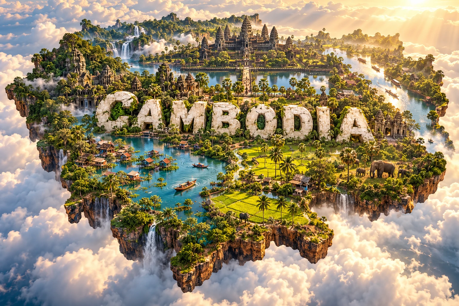
The Cambodia artwork combines Angkor Wat-inspired towers, jungle-covered ruins, Tonlé Sap, green rice paddies, sugar palms, Mekong-like waterways, elephants and Khmer architectural motifs. Embedded “CAMBODIA” lettering turns these elements into a compact floating micro-world.
The elements refer to real themes but not one real location. Angkor lies near Siem Reap; the Mekong crosses eastern Cambodia; Tonlé Sap occupies the central-western basin; and wild elephants are restricted mainly to particular forest landscapes. Temple vegetation also varies: Angkor includes maintained monuments, inhabited villages, forest and archaeological areas rather than being uniformly jungle-covered.
The image is a conceptual artistic composition. The landmarks, wildlife and landscapes are combined for educational visualization and are not shown at their true geographic positions or scale. It is not a satellite map, and the elephant does not imply that wild elephants occur across Cambodia.
12. Interesting Facts About Cambodia
- Cambodia's central plain is surrounded by uplands on several sides.
- It borders Thailand, Laos and Vietnam and has a Gulf of Thailand coast.
- During the wet season, the Tonlé Sap River reverses toward the lake.
- Tonlé Sap can expand to several times its dry-season area.
- The flood pulse creates temporary feeding and breeding habitat for fish.
- Phnom Penh developed near the meeting of major waterways.
- Phnom Aural is Cambodia's highest point at about 1,813 meters.
- Angkor includes hydraulic works and former urban landscapes as well as temples.
- Cambodia currently has five properties on UNESCO's World Heritage List.
- Koh Ker briefly served as a Khmer imperial capital in the tenth century.
- The giant ibis survives only in restricted habitats, not nationwide.
- Irrawaddy dolphins inhabit a limited reach of the northeastern Mekong.
- Cambodia became independent from France in 1953.
- Khmer Rouge rule lasted from April 1975 to January 1979 and caused nearly two million deaths.
- Sbek Thom shadow theatre uses large leather puppets and precise dance movements.
13. Short Quiz
-
Why does the Tonlé Sap River reverse during the wet season? A. Tides pull it toward the mountains B. Rising Mekong water pushes flow toward the lake C. Glaciers melt in Cambodia D. The lake becomes saltwater
-
Where are Cambodia's largest mountain forests concentrated? A. The southwest B. The center of Phnom Penh C. The Tonlé Sap lakebed D. The southeastern delta only
-
What does Angkor contain besides temples? A. Glaciers and fjords B. Reservoirs, canals, roads and urban remains C. Roman amphitheaters D. Modern oil refineries
-
Where do Cambodia's Irrawaddy dolphins live? A. Every rice paddy B. A limited stretch of the northeastern Mekong C. Only in the Gulf of Thailand D. Mountain waterfalls nationwide
-
How should the 3D artwork be interpreted? A. As an exact satellite map B. As proof that elephants live at Angkor Wat C. As a conceptual combination of Cambodian themes D. As a measurement of temple size
Answer key: 1-B, 2-A, 3-B, 4-B, 5-C.
14. Related Learning
Suggested internal-link topics:
- Thailand Explained: Mountains, Monsoons, Rivers and Culture
- Laos Explained: Mekong Landscapes, Forests and Culture
- Vietnam Explained: Deltas, Mountains, Climate and Culture
- Why Does the Tonlé Sap River Reverse Direction?
- How the Mekong Flood Pulse Supports Fish and Farms
- How Angkor's Reservoirs and Canals Worked
- Why Monsoon Winds Create Cambodia's Wet and Dry Seasons
- How Flooded Forests Protect the Tonlé Sap Ecosystem
- Why Irrawaddy Dolphins Are Restricted to Part of the Mekong
- How Archaeologists Study the Urban Landscape of Angkor
15. Sources
- Cambodia National Institute of Statistics — General Population Census of Cambodia 2019
- World Bank — Cambodia overview
- World Bank — Cambodia Economic Update, June 2025
- Mekong River Commission — Procedures and Tonlé Sap reverse flow
- UNESCO — Tonlé Sap Biosphere Reserve
- UNESCO World Heritage Centre — Cambodia
- UNESCO World Heritage Centre — Angkor
- UNESCO Intangible Cultural Heritage — Sbek Thom, Khmer shadow theatre
- WWF-Cambodia — Biodiversity research and monitoring
- WWF-Cambodia — Giant ibis
- United States Holocaust Memorial Museum — Cambodia 1975–1979