

Botswana is a landlocked Southern African country where a great inland river spreads across Kalahari sands instead of reaching the ocean. The Okavango Delta's seasonal flood creates channels, lagoons and grasslands in the north, while dry savanna, salt pans and cattle country cover much of the rest of the nation.
This contrast makes Botswana especially useful for learning how climate, geology and water interact. It also supports globally important wildlife, although elephants, lions and zebras occupy particular habitats rather than every part of the country.
1. Where Is Botswana?
Botswana lies in Southern Africa. Namibia borders it to the west and north, South Africa to the south and southeast, and Zimbabwe to the northeast. A very short boundary with Zambia crosses the Zambezi near Kazungula. Botswana has no coastline.
Gaborone, close to the southeastern border with South Africa, is the capital and largest city. Francistown is the second-largest city and an older mining and transport center. Maun is the main urban gateway to the Okavango region, while Kasane lies near the Chobe and Zambezi rivers. Other important settlements include Molepolole, Serowe, Kanye, Mahalapye, Palapye, Lobatse and the mining towns of Jwaneng and Orapa.
The population and most farming are concentrated in the better-watered east, along a corridor sometimes called the hardveld. Western and central districts are much more sparsely settled.
2. Quick Country Facts
- Official name: Republic of Botswana
- Capital: Gaborone
- Region: Southern Africa
- Area: 581,730 square kilometers
- Population: 2,359,609 people counted in the 2022 census
- Currency: Botswana pula (BWP)
- Official language: English
- National language: Setswana; many other languages are spoken
- Time zone: Central Africa Time (UTC+2) throughout the year
- Highest point: Otse Hill, commonly listed at about 1,491 meters
- Major water systems: Okavango, Chobe–Linyanti, Limpopo and seasonal Makgadikgadi drainage
- Major ecosystems: Dry savanna, Kalahari shrubland, woodland, salt pans, wetlands and river floodplains
The 2022 census is a counted population rather than a current projection. Estimates for later years will differ because of births, deaths and migration.
3. Geography and Landscape
Botswana is mostly a broad plateau about 900 to 1,100 meters above sea level. It is generally flat or gently rolling, with low hills and rocky outcrops more common in the east. Deep Kalahari sand covers most of the country and conceals much of the underlying bedrock.
The Kalahari is not simply an endless field of dunes. It is a vast sandy basin containing grassland, thorn scrub, open woodland, fossil river valleys and pans. Much of Botswana's Kalahari supports vegetation and grazing wildlife, although rainfall becomes very low toward the southwest.
In the northwest, the Okavango River arrives from Angola through Namibia and spreads into a huge alluvial fan. Channels divide repeatedly, water spills onto floodplains, and islands rise slightly above seasonal inundation. Most water is ultimately lost through evaporation and plant use or sinks into sand; the river normally does not reach the sea.
East of the delta, the Makgadikgadi Pans form a system of broad, saline flats. Ntwetwe and Sua are among the largest. They remain dry and crusted for long periods but can hold shallow water after sufficient rain, attracting waterbirds and grazing animals to their margins.
Northern Botswana also includes the Chobe and Linyanti floodplains. The southeast drains toward the Limpopo system, while many central and western channels are seasonal or fossil remnants of wetter climates.
4. Why Does Botswana Look Like This?
Botswana occupies the Kalahari Basin, a long-lived interior depression filled with sand and river or lake sediments. Because slopes are gentle and surrounding highlands interrupt routes to the sea, drainage across much of the interior is weak or inward-flowing.
The Okavango begins in the rainy highlands of Angola as the Cubango and Cuito river system. Floodwater travels slowly south through channels and wetlands. It reaches the delta in Botswana months after the upstream rains, often expanding during Botswana's dry winter. The delay results from the enormous distance, gentle gradient, floodplain storage and friction from vegetation.
The delta sits between geological faults that help guide and spread its channels. Sediment carried by water, termite-built mounds and vegetation alter flow locally, creating a shifting mosaic of islands and floodplains. It is technically an alluvial fan or inland delta, not a coastal river mouth.
The Makgadikgadi Pans are remnants of a much larger prehistoric lake. Climate shifts and changing river courses reduced the lake, while evaporation concentrated salts on the basin floor. Wind and seasonal water continue to reshape its surface.
Kalahari sand is highly permeable, so rainfall often soaks in rather than forming permanent surface streams. High evaporation and unreliable rain further explain why surface water is scarce across most of the country.
5. Climate
Botswana is arid to semi-arid. Rain falls mainly during the warm season, broadly from October or November to March or April, usually in localized thunderstorms. Annual amounts generally increase from the dry southwest toward the northeast, but totals vary greatly between years.
Summers can be extremely hot, especially before rain arrives. Winters from roughly May to August are sunny and dry, with warm days but cold nights. Frost can occur, particularly in the south and in low-lying places.
Drought is a recurring feature rather than an unusual accident. The El Niño–Southern Oscillation and regional circulation can shift rainfall, but no single event explains every wet or dry year.
The Okavango's local flood does not depend mainly on rain falling over the delta. Its water comes overwhelmingly from the upstream international basin. This makes cooperation with Angola and Namibia essential.
Climate change raises temperatures and evaporation and can intensify drought, heat and wildfire risk. Rainfall projections carry uncertainty, but greater variability would affect livestock, crops, urban water supplies, wildlife and wetland livelihoods.
6. Wildlife and Ecosystems
Northern Botswana supports elephants, African buffalo, hippos, lions, leopards, cheetahs, spotted hyenas, African wild dogs, giraffes and many antelope species. Their distribution changes with water, vegetation, fences and season. Elephants are especially numerous in northern districts, not evenly spread nationwide.
The Okavango Delta provides permanent channels, seasonal floodplain, reed beds, woodland and dry islands. Red lechwe are adapted to shallow floodwater, while sitatunga use denser wetland vegetation. Fish, crocodiles, frogs, insects and waterbirds respond to the annual flood pulse.
Chobe National Park and adjoining conservation areas protect riverfront, woodland and savanna used by large elephant and buffalo herds. The region connects with habitats in Namibia, Zambia, Zimbabwe and Angola, so effective conservation is transboundary.
Central Kalahari landscapes support gemsbok, springbok, wildebeest, brown hyenas, lions and smaller desert-adapted animals. In Makgadikgadi and Nxai Pan, zebra and wildebeest move seasonally toward water and fresh grass. Flamingos breed on Sua Pan only when suitable flooding creates food and nesting conditions.
Veterinary fences protect cattle from some diseases but can block wildlife migrations. Other pressures include drought, human–wildlife conflict, illegal killing, habitat conversion, changing fire patterns and possible upstream water development. Conservation decisions affect local communities as well as wildlife.
7. Famous Landmarks and Natural Features
The Okavango Delta is a UNESCO World Heritage property and one of the world's largest inland wetland systems. Its importance comes from an annual flood that sustains diverse habitats in an otherwise dry region.
Tsodilo Hills rise abruptly from northwestern Kalahari sands. UNESCO records more than 4,500 rock paintings in a small area and archaeological evidence spanning at least 100,000 years. The hills remain sacred to San and Hambukushu communities; they are not merely an outdoor art gallery.
The Makgadikgadi Pans preserve the floor of an ancient lake. Their salt flats, grasslands and seasonal pools support flamingos and migrations when water and vegetation permit.
Chobe National Park protects important northern riverfront and woodland habitats. The Chobe River is particularly significant during the dry season when animals concentrate around water.
The Central Kalahari Game Reserve is one of the world's largest protected areas. It includes dry grassland, scrub and fossil valleys such as Deception Valley, rather than a uniformly barren desert.
The Tswapong and Gcwihaba landscapes reveal other sides of Botswana: rocky hills, springs and cave systems within a country often imagined as completely flat.
8. People, Languages and Culture
Most citizens are collectively called Batswana; one person is a Motswana. These national terms should not be confused with a claim that everyone belongs to the same ethnic or linguistic community.
Setswana is the national language and is widely spoken, while English is used officially in government and education. Kalanga, Sekgalagadi, Shiyeyi, Thimbukushu, Naro, Gǀui, Gǁana and other languages reflect substantial cultural diversity. Language names and spellings vary across communities and orthographies.
Tswana-speaking polities developed systems of leadership centered on dikgosi and public meeting places called kgotla. Consultation at a kgotla remains an important civic ideal, but modern Botswana is a constitutional republic with elected institutions, not simply an extension of traditional rule.
The territory became the British Bechuanaland Protectorate in 1885. Botswana gained independence in 1966 under its first president, Seretse Khama. Diamond discoveries soon transformed public revenue, though cattle and migrant labor had already shaped livelihoods and regional connections.
San communities have deep histories in the Kalahari and diverse languages, knowledge and identities. They should not be described as people frozen in a prehistoric way of life. Displacement, land access and participation in conservation remain important contemporary rights issues.
Basket weaving in the northwest uses palm fibers and distinctive patterns. Music, dance, poetry, cattle traditions, Christian practice and ancestral beliefs vary across communities. The zebra is a national symbol, but cultural life cannot be reduced to wildlife imagery.
9. Food
Seswaa is slowly cooked, pounded beef or goat often served at gatherings. Bogobe is a sorghum, maize or millet porridge whose consistency and accompaniments vary. Sorghum is especially suited to dry conditions.
Dikgobe combines beans or peas with grains such as sorghum or maize. Morogo refers to cooked leafy greens, including cultivated or gathered plants. Madila is cultured sour milk, reflecting the importance of cattle and dairy in many households.
In northern wetland areas, fish and water-associated foods are more significant. Melons, beans, groundnuts and wild foods contribute seasonally. Diets today also include imported staples and urban foods, so no short menu represents all Batswana.
10. Economy and Major Industries
Diamonds transformed Botswana from a low-income country at independence into an upper-middle-income economy. Mining remains central to exports, government revenue and national output. This success also creates vulnerability when global diamond demand weakens.
The World Bank reported that the economy contracted by 2.8 percent in 2024 and an estimated 0.7 percent in 2025 amid weaker diamond revenue and fiscal pressure. These are dated estimates and may be revised. The downturn reinforces the importance of diversification.
Services include government, finance, retail, transport, communications and tourism. Nature-based tourism focuses heavily on the Okavango, Chobe and other protected landscapes. A high-value, lower-volume model can limit some pressures, but benefits, land use and access still require fair management.
Cattle ranching has economic and cultural importance, while crop production is constrained by erratic rain and sandy soils. Farmers grow sorghum, maize, millet, beans and other crops in suitable areas. Beef exports must meet animal-health standards, one reason veterinary fences shape the landscape.
Manufacturing, renewable energy, digital services and mineral processing are diversification priorities. Persistent challenges include unemployment, inequality, poverty, water scarcity and dependence on diamonds despite strong institutions and major development gains.
11. What the 3D Visual Represents
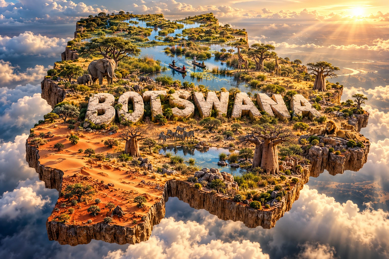
The Botswana artwork combines the Okavango Delta, Kalahari vegetation, winding channels, baobabs, elephants, giraffes, lions, zebras and mokoro-inspired canoes. Embedded “BOTSWANA” lettering turns these geographically separate themes into a single floating micro-world.
A mokoro is a narrow craft traditionally made from a tree trunk and increasingly from fiberglass; it is especially associated with travel in shallow Okavango channels. Baobabs are prominent in suitable northern and eastern localities, while extensive wetland is confined to the north. Large mammals move through particular protected and communal landscapes rather than covering the entire country.
The image is a conceptual artistic composition. The landmarks, wildlife and landscapes are combined for educational visualization and are not shown at their true geographic positions or scale. It is not a satellite map, wildlife-distribution map or depiction of one real location.
12. Interesting Facts About Botswana
- Botswana is landlocked in Southern Africa.
- The 2022 census counted 2,359,609 residents.
- Kalahari sand covers most of the country.
- The Kalahari contains vegetated savanna, not only bare dunes.
- Okavango floodwater begins as rain in Angola.
- The main flood reaches Botswana during its dry season.
- Most Okavango water never reaches an ocean.
- Makgadikgadi's salt pans are remnants of a prehistoric lake.
- Tsodilo preserves more than 4,500 recorded rock paintings.
- Botswana became independent in 1966.
- Pula, the currency's name, also means rain in Setswana.
- Northern Botswana supports one of Africa's largest elephant populations.
- Flamingos breed at Sua Pan only in favorable wet conditions.
- Veterinary fences can interrupt wildlife migrations.
- Diamond dependence remains both an economic strength and a risk.
13. Short Quiz
-
Where does most water feeding the Okavango Delta originate? A. Angola's highlands B. The Atlantic coast C. Lake Victoria D. Madagascar
-
Why is the Okavango called an inland delta? A. It freezes each winter B. Its river spreads inland instead of entering the sea C. It is entirely artificial D. It lies below sea level
-
What created the Makgadikgadi Pans? A. A vanished ancient lake B. A coral reef C. Recent glaciers D. Ocean tides
-
Why is Tsodilo important? A. It is Botswana's main port B. It contains rock art, archaeology and living sacred traditions C. It is an active volcano D. It is the capital
-
How should the 3D artwork be interpreted? A. As an exact habitat map B. As one photographed landscape C. As a conceptual combination of distant features D. As a flood forecast
Answer key: 1-A, 2-B, 3-A, 4-B, 5-C.
14. Related Learning
Suggested internal-link topics:
- Namibia Explained: Namib Desert, Coast and Wildlife
- South Africa Explained: Plateaus, Coasts, Culture and Wildlife
- Zimbabwe Explained: Plateaus, Rivers and Great Zimbabwe
- Zambia Explained: Rivers, Plateaus and Victoria Falls
- Why the Okavango Delta Floods During the Dry Season
- How the Kalahari Differs from a Sand-Dune Desert
- How Ancient Lake Makgadikgadi Became Salt Pans
- Why Wildlife Migrations Cross National Borders
- How Veterinary Fences Affect Kalahari Animals
- What Tsodilo Rock Art Reveals About Human History
15. Sources
- Statistics Botswana — 2022 Population and Housing Census
- Government of Botswana — About Our Country
- World Bank — Botswana overview
- World Bank — Botswana Economic Update
- FAO — Botswana country profile
- UNESCO — Okavango Delta
- UNESCO — Tsodilo
- UNESCO — Makgadikgadi Pans Landscape
- Convention on Wetlands — Okavango Delta System
- Encyclopaedia Britannica — Botswana