

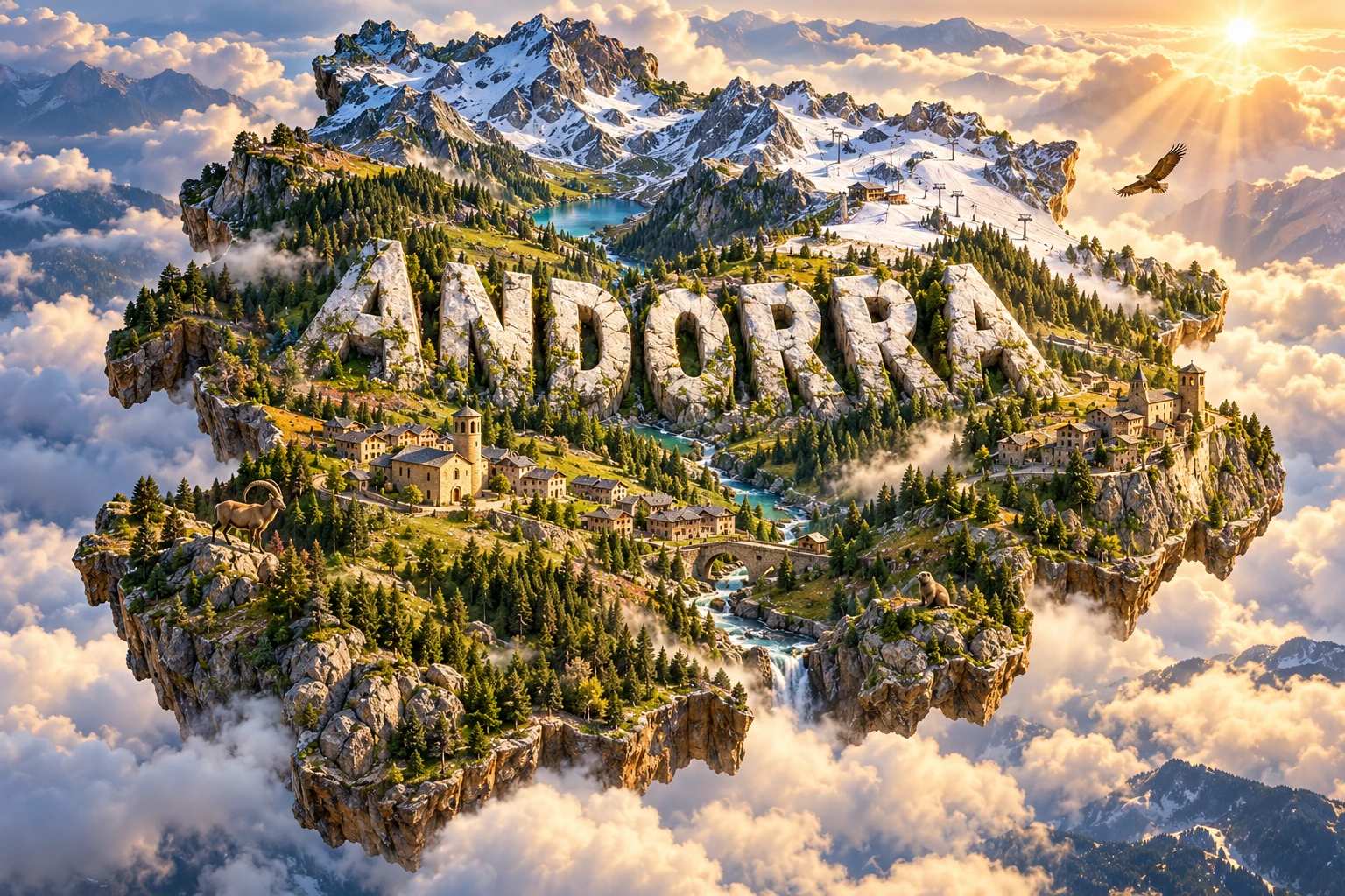
Andorra is a small landlocked country entirely within the eastern Pyrenees. Its steep valleys, high peaks, glacial lakes and forests make elevation the organizing force of its geography: settlements and roads follow valley floors, while climate, vegetation and wildlife change rapidly uphill.
The country is also a parliamentary co-principality with Catalan as its official language. Romanesque churches, communal pasture and old mountain routes coexist with ski areas, dense valley towns, banking and an economy strongly shaped by international visitors.
1. Where Is Andorra?
Andorra lies in southwestern Europe between France to the north and Spain to the south. Spain's neighboring territory is Catalonia, while the French side belongs to the department of Ariège. Andorra has no coastline and no other international borders.
The country occupies several high valleys in the eastern Pyrenees. Andorra la Vella, the capital, sits where mountain streams join the Gran Valira valley. Escaldes-Engordany forms part of the same urban area, while Encamp, Canillo, La Massana, Ordino and Sant Julià de Lòria anchor other valleys and parishes.
Roads cross into Spain along the Valira valley and into France over the Envalira route. Mountain barriers make these connections vulnerable to snow, ice, avalanches and steep terrain, even though modern tunnels and road engineering have improved access.
2. Quick Country Facts
- Official name: Principality of Andorra
- Capital: Andorra la Vella
- Region: Southwestern Europe; eastern Pyrenees
- Area: Approximately 468 square kilometers
- Population: Approximately 83,000 in the United Nations' 2025 estimate
- Currency: Euro (EUR), used through a monetary agreement although Andorra is not an EU member
- Official language: Catalan; Spanish, French and Portuguese are also widely used
- Time zone: Central European Time (UTC+1), with summer daylight saving time (UTC+2)
- Highest point: Comapedrosa, 2,942 meters
- Lowest point: Near the Riu Runer on the Spanish border, about 840 meters
- Major river system: The Valira and its tributaries, which drain south into Spain and the Segre–Ebro system
- Government: Parliamentary co-principality divided into seven parishes
Andorra is one of Europe's microstates. Its small area should not be confused with uniform terrain: more than two kilometers of vertical relief separate its lowest border valley from its highest summit.
3. Geography and Landscape
Mountain ridges enclose Andorra on nearly every side. Dozens of summits exceed 2,000 meters, and Comapedrosa reaches 2,942 meters in the northwest. Flat land is scarce, so towns, agriculture and transport concentrate along narrow valley floors and gentler lower slopes.
The Valira system gathers water from the country's main valleys. The Valira del Nord drains the Ordino and La Massana area, while the Valira d'Orient flows through Canillo and Encamp. They join near Escaldes-Engordany and continue south as the Gran Valira before entering Spain.
High basins hold small lakes known locally as estanys. Many occupy hollows excavated by former glaciers or are dammed by glacial debris. Mountain streams descend steeply, so rainfall and rapid snowmelt can produce floods in developed valley bottoms.
Forests cover substantial middle elevations. Scots pine, mountain pine, fir, birch and deciduous woodland occur according to altitude, slope direction and soil. Above the treeline, alpine and subalpine grasslands provide summer grazing and habitat for mountain species.
The Madriu-Perafita-Claror Valley in the southeast preserves a particularly continuous sequence from wooded lower valley to open high pasture and rocky glacial terrain. Elsewhere, ski infrastructure, roads, housing and commercial development have transformed parts of the landscape.
4. Why Does Andorra Look Like This?
The Pyrenees formed mainly when the Iberian and Eurasian continental plates converged. Compression from the Late Cretaceous into the Cenozoic folded and faulted sedimentary rocks and uplifted older granite, gneiss and other rocks from deep in the crust. Andorra sits near the high axial zone of this mountain belt.
Tectonic uplift created height, but erosion carved the landscape people see today. Rivers cut into the rising mountains, following zones of weakness and carrying broken rock downstream. Freeze-thaw weathering continues to loosen exposed stone on high slopes.
During colder periods of the Quaternary, valley glaciers flowed through Andorra. Moving ice widened and deepened valleys into U-shaped cross sections, excavated lake basins and sharpened ridges between neighboring glaciers. When the ice retreated, it left moraines—ridges and sheets of transported sediment—and unstable material on valley sides.
This glacial inheritance explains the contrast between broad high basins and narrow downstream gorges. It also influences hazards. Steep slopes, loose sediment, heavy rain, snow loading and rapid thaw can contribute to rockfalls, landslides, avalanches and floods.
Slope direction creates small environmental differences. Sunny south-facing slopes are warmer and often drier than shaded north-facing slopes at the same elevation. Over a compact area, these “microclimates” help produce a mosaic of forest, meadow, pasture, scree and exposed rock.
5. Climate
Andorra has a mountain climate influenced by both the Atlantic and Mediterranean regions. Elevation causes large local differences: lower valleys are generally warmer, while high ground has cooler summers, long winters and persistent seasonal snow.
Precipitation falls throughout the year, as rain at lower elevations and snow in winter and spring at higher elevations. Storms can be intense because mountains force moving air upward. Valley orientation and exposure determine how much precipitation individual locations receive.
Winter snow supports ski tourism and stores water that is released during spring melt. The depth and duration of snow cover vary greatly from year to year. Artificial snowmaking can supplement ski slopes but requires water and energy.
Climate change is raising temperatures, reducing the reliability and duration of natural snow at lower elevations, shifting habitats uphill and increasing heat and drought stress. Heavy rainfall, wildfire risk and changing seasonal streamflow also affect infrastructure and ecosystems. A small mountain country has limited space in which cold-adapted species can retreat.
6. Wildlife and Ecosystems
Andorra's elevation zones support different communities. Lower slopes contain mixed woodland and Mediterranean-influenced plants; conifer forest dominates many higher slopes; and alpine grassland, scree and rock occur above the treeline.
The Pyrenean chamois, called isard in Catalan, uses steep mountain terrain and alpine pasture. Roe deer, wild boar, red foxes, martens and small mammals inhabit suitable forests and slopes. These species are not equally distributed across every valley.
Alpine marmots now live in high meadows, but they were reintroduced to the Pyrenees during the 20th century after disappearing from the range in prehistoric times. Calling them native without this historical qualification would be misleading.
Birds include golden eagles, griffon vultures and the bearded vulture, a large scavenger strongly associated with mountain landscapes. The western capercaillie occupies limited mature forest habitat and is sensitive to disturbance and habitat change. Andorra's 2024 protected-fauna update increased protection for species including the stoat, boreal owl and Pyrenean rock lizard.
Sorteny Valley, the Comapedrosa Valleys and Madriu-Perafita-Claror protect high-mountain habitats and wetlands. Conservation must also extend beyond reserves because roads, ski facilities and settlements divide habitats, while animals move across the borders with France and Spain.
7. Famous Landmarks and Natural Features
Madriu-Perafita-Claror Valley is Andorra's only UNESCO World Heritage property. Covering about nine percent of the country, this cultural landscape contains glacial terrain, forests, pasture, shepherd shelters, terraced fields, stone paths and evidence of ironworking. It demonstrates how communities used limited high-mountain resources over centuries.
Comapedrosa is the country's highest mountain. Its surrounding valleys preserve glacial lakes, alpine meadow and rocky habitat. The peak is a natural feature rather than a viewpoint representative of conditions everywhere in Andorra.
The Sorteny Valley is known for diverse mountain flora, wetlands and trails through subalpine and alpine environments. The Tristaina lakes occupy a glacial basin in the north and illustrate how ice shaped the high Pyrenees.
Andorra preserves a notable group of Romanesque churches, generally modest stone buildings adapted to small medieval communities. Sant Joan de Caselles has a prominent bell tower; Santa Coloma includes a round Romanesque tower; and Sant Miquel d'Engolasters overlooks the central valley. Their surviving art and architecture belong to specific dates and restoration histories.
Casa de la Vall, built as a house in the late 1500s and later used by the General Council, represents Andorra's political institutions. The nearby modern parliament building shows that the country's government is living and contemporary rather than a medieval survival unchanged through time.
Caldea, a modern thermal spa complex in Escaldes-Engordany, makes use of naturally warm water circulating through fractured rock. It is visually distinct from the stone churches and demonstrates a newer phase of valley development.
8. People, Languages and Culture
Catalan is Andorra's sole official language and an important marker of national identity. Spanish, French and Portuguese are also common because of neighboring countries, education systems and immigration. Many residents use more than one language in daily life.
Only a portion of residents are Andorran citizens; substantial Spanish, Portuguese, French and other communities live and work in the country. Citizenship, language and birthplace therefore should not be treated as interchangeable identities.
Andorra's head-of-state arrangement is unusual. Its two co-princes are the Bishop of Urgell in Spain and the president of France. Their roles are defined by the 1993 constitution, while elected institutions govern through a parliamentary system. The General Council is the legislature, and the head of government leads the executive.
The arrangement developed from medieval agreements called pariatges, which settled competing claims between the Bishop of Urgell and the Count of Foix in 1278 and 1288. Historical rights passed through the French line to today's French presidency. Andorra adopted its modern constitution and joined the United Nations in 1993.
Traditional livelihoods combined livestock, seasonal movement between pastures, small fields, forestry, ironworking and cross-border exchange. Communal land management remains visible in the landscape. Summer solstice fire festivals and transhumance link Andorra with wider Pyrenean traditions recognized by UNESCO.
Folk dances, music, parish festivals and craft practices differ locally. Stone walls and slate roofs are prominent in historic building, but much of today's built environment is modern. Presenting every resident in pastoral dress would ignore Andorra's urban, multilingual and internationally connected society.
9. Food
Andorran food draws on Catalan and wider Pyrenean traditions. Escudella is a substantial soup or stew with vegetables, pasta or rice and various meats; recipes change by household and occasion. Trinxat combines cabbage and potato, often with pork.
Mountain livestock traditions contribute cheeses, sausages and other preserved meats. Truites de carreroles are omelets made with mushrooms when season and availability allow. Game appears in some traditional dishes, while modern restaurants reflect the country's diverse resident population and visitors.
Local production is limited by steep slopes and a short growing season. Historically, households depended on careful storage and trade as well as farming. Today, most food is imported, although livestock, small-scale crops and specialty products retain cultural value.
10. Economy and Major Industries
Services dominate Andorra's economy. Mountain and ski tourism, shopping, hotels, restaurants, transport and leisure activities draw visitors from France, Spain and farther away. This creates jobs but also produces seasonal traffic, high water and energy demand, waste and pressure on land and housing.
Banking and financial services remain important under stronger international transparency and regulatory standards than in earlier decades. Retail trade benefits from cross-border visitors, while construction responds to tourism, infrastructure and residential demand.
The IMF reported that growth in 2024 was driven by services, banking and construction. It also identified housing and labor shortages, climate change, pension costs and the need for higher-value and more diverse economic activity as long-term issues.
Agriculture is a very small part of national output. Livestock, tobacco and limited crops persist where terrain permits. Hydroelectricity contributes to domestic power, but Andorra imports much of its energy and goods through France and Spain.
Climate risk is also economic risk. Shorter or less reliable snow seasons affect winter sports, while floods, avalanches and wildfire can damage infrastructure. Diversifying year-round activities does not eliminate the need to protect habitats and manage visitor pressure.
11. What the 3D Visual Represents
The Andorra artwork combines Pyrenean peaks, alpine valleys, stone villages, Romanesque churches, ski slopes, forests and mountain wildlife. Monumental “ANDORRA” lettering and a floating country outline compress multiple elevations, seasons and parishes into one miniature scene.
The elements reflect real themes but do not form one actual view. Romanesque churches stand in particular villages; ski areas occupy developed slopes; protected valleys retain different levels of infrastructure; and wildlife uses specific habitats. Snow cover also changes with elevation, season and weather.
The image is a conceptual artistic composition. The landmarks, wildlife and landscapes are combined for educational visualization and are not shown at their true geographic positions or scale. It is not a satellite map, an exact church reconstruction or a guide to animal distribution.
12. Interesting Facts About Andorra
- Andorra lies entirely within the Pyrenees between France and Spain.
- It covers only about 468 square kilometers but has more than 2,100 meters of vertical relief.
- Andorra la Vella is among Europe's highest national capitals.
- Comapedrosa is the country's highest point at 2,942 meters.
- Catalan is the sole official language, while Spanish, French and Portuguese are also widely used.
- The country has two co-princes: the Bishop of Urgell and the president of France.
- Andorra is not an EU member but uses the euro through a monetary agreement.
- The Valira drains south into the Segre and ultimately the Ebro river system.
- Former glaciers carved many of Andorra's U-shaped valleys and high lake basins.
- Madriu-Perafita-Claror covers about nine percent of the national territory.
- The Madriu valley preserves evidence of pasture, terraced farming, stone routes and ironworking.
- Alpine marmots in the Pyrenees descend from modern reintroductions rather than an uninterrupted native population.
- Seven parishes form Andorra's main administrative divisions.
- The country's modern constitution took effect in 1993.
- Tourism, retail, finance and construction are much larger economic activities than agriculture.
13. Short Quiz
-
Which mountain range contains Andorra? A. Alps B. Pyrenees C. Carpathians D. Apennines
-
What process formed many of Andorra's U-shaped valleys? A. Coral growth B. Glacial erosion C. Desert winds D. Ocean tides
-
What is Andorra's official language? A. French B. Spanish C. Catalan D. Portuguese
-
Why is Madriu-Perafita-Claror important? A. It is an offshore island B. It preserves a high-Pyrenean cultural landscape C. It is a modern airport D. It contains a tropical rainforest
-
How should the 3D artwork be interpreted? A. As an exact satellite image B. As a conceptual combination of distant features C. As one real village D. As an animal-range map
Answer key: 1-B, 2-B, 3-C, 4-B, 5-B.
14. Related Learning
Suggested internal-link topics:
- France Explained: Mountains, Rivers, Culture and Regions
- Spain Explained: Plateaus, Coasts, Islands and Culture
- How the Pyrenees Formed
- How Glaciers Carved Andorra's Valleys
- Why Mountain Climates Change with Elevation
- How Andorra Became a Co-Principality
- How Romanesque Churches Were Built in the Pyrenees
- Why Snowmelt Matters to Mountain Rivers
- How Climate Change Is Affecting Ski Regions
- How Transhumance Shaped Pyrenean Landscapes
15. Sources
- United Nations Data — Andorra country profile
- Government of Andorra — Andorra in figures
- Government of Andorra — official language law
- Government of Andorra — climate action report
- Government of Andorra — protected fauna update
- UNESCO — Madriu-Perafita-Claror Valley
- UNESCO — Andorra World Heritage profile
- International Monetary Fund — Andorra 2025 Article IV Consultation
- Institut Cartogràfic i Geològic de Catalunya — the Iberian Plate
- Spanish National Geographic Institute — tectonic framework of the Pyrenees
- Pyrenees National Park — geological and climatic history