

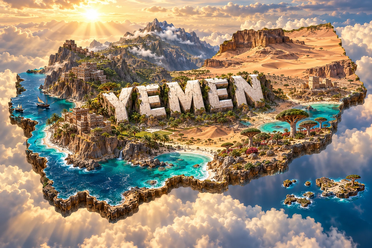
Yemen occupies the mountainous southwestern corner of the Arabian Peninsula, where highlands intercept seasonal rain above hot coastal plains and deserts. Ancient communities built terraces, dams and remarkable mud-brick cities to manage scarce water. Offshore, the isolated Socotra Archipelago supports plants and animals found nowhere else. These deep geographic and cultural stories remain important even as conflict and humanitarian crisis shape present-day life.
1. Where Is Yemen?
Yemen lies in Western Asia at the southern end of the Arabian Peninsula. Saudi Arabia borders it to the north and Oman to the east. The Red Sea lies to the west, while the Gulf of Aden and Arabian Sea border the south. Across the Bab al-Mandab strait are Djibouti and Eritrea in the Horn of Africa.
The country includes mainland territory and many islands. Socotra, the largest island, lies far to the southeast near the entrance to the Gulf of Aden. Other islands occupy the Red Sea. Yemen's position beside the Bab al-Mandab places it near a narrow shipping route connecting the Red Sea and Suez Canal with the Indian Ocean.
Sana'a is the constitutional capital. Because of the continuing conflict and divided control, Aden has served as a temporary seat of the internationally recognized government. Descriptions of current administration should be dated rather than presented as permanent geography.
2. Quick Country Facts
| Fact | Detail |
|---|---|
| Official name | Republic of Yemen |
| Constitutional capital | Sana'a |
| Temporary government seat | Aden, amid continuing divided control |
| Region | Western Asia; southwestern Arabian Peninsula |
| Area | About 528,000 square kilometres |
| Population | About 41 million in recent international estimates; uncertainty is substantial |
| Currency | Yemeni rial (YER) |
| Official language | Arabic |
| Time zone | Arabia Standard Time, UTC+3 |
| Highest point | Jabal an-Nabi Shu'ayb, about 3,666 metres |
| Major island group | Socotra Archipelago |
| Coasts | Red Sea, Gulf of Aden and Arabian Sea |
War, displacement and limited statistical coverage make precise current population and economic figures difficult. Responsible summaries identify estimates and dates.
3. Geography and Landscape
Along the Red Sea lies the Tihama, a hot, low coastal plain of beaches, dunes, wadis and agricultural areas. Eastward, the land rises abruptly through foothills into Yemen's western highlands. Peaks exceed 3,000 metres, and deeply cut valleys separate ridges, basins and terraced slopes. Sana'a stands on a high interior plateau.
The highlands descend eastward into plateaus and the broad Hadramawt region, whose great wadis hold towns, farms and seasonal watercourses. Farther northeast, increasingly arid land merges toward the Rub' al Khali, or Empty Quarter. Yemen has no permanent river comparable to the Nile. Wadis may remain dry for much of the year and then carry destructive flash floods after intense rain.
The southern coast includes volcanic and sedimentary landscapes around Aden, long beaches, cliffs and fishing communities. Socotra's limestone plateaus, granite mountains, caves, dunes and coastal plains evolved in long isolation from mainland Arabia and Africa.
Stone agricultural terraces cover many western slopes. They are human-built landscapes that slow runoff, retain soil and make cultivation possible on steep ground. When terrace walls fail, erosion and flood risk increase below them.
4. Why Does Yemen Look Like This?
Yemen stands near the meeting region of the Arabian, African and Somali plates. Rifting opened the Red Sea and Gulf of Aden as Arabia separated from Africa. Faulting and uplift raised western and southern highlands, while volcanic activity left lava fields, craters and the rugged setting around Aden.
Uplift gave the western mountains enough height to force moist air upward. Cooling air releases rain, so some highland slopes receive far more water than surrounding deserts. Streams cut steep valleys, but high evaporation and irregular rainfall prevent most from becoming permanent rivers.
Socotra separated from neighboring land through the opening of the Gulf of Aden. Long isolation, varied rock and strong seasonal winds allowed species to evolve independently. This helps explain its high endemism—the occurrence of organisms found naturally nowhere else.
People have reshaped these physical systems for millennia. Terraces catch soil and rain on mountains. Cisterns store roof runoff. In wadis, farmers divert short-lived floods through spate irrigation. The ancient Marib Dam controlled seasonal flows for agriculture in the Sabaean heartland. Yemen's landscape is therefore both geological and engineered.
5. Climate
Yemen is mainly arid or semi-arid, but altitude, coast and monsoon circulation create sharp contrasts. The Tihama and southern coasts are hot, with high humidity near the sea and little reliable rainfall. Eastern deserts are also very dry and experience large temperature swings.
Highland temperatures are milder. Sana'a's elevation produces warm days, cool nights and sometimes near-freezing winter conditions. Western and southwestern highlands receive the most rain, often in two seasonal peaks linked to spring circulation and the northward movement of tropical rain belts in summer.
Socotra experiences powerful seasonal winds associated with the Indian Ocean monsoon. Rainfall and cloud vary greatly with elevation and exposure. Tropical cyclones occasionally reach Socotra and Yemen's southern coast, bringing destructive rain, wind and flooding to normally dry landscapes.
Climate change intensifies heat, erratic rainfall, drought and flood risk. Water scarcity is worsened by groundwater extraction, damaged infrastructure and high demand. A short storm can provide urgently needed water while also sweeping away roads, houses, crops and weakened terraces.
6. Wildlife and Ecosystems
Socotra is Yemen's best-known biodiversity centre. Its dragon's blood tree has an umbrella-shaped crown and red resin, but it grows naturally in particular upland habitats—not across mainland Yemen. The island group also supports endemic frankincense trees, aloes, reptiles, land snails and birds. UNESCO reports exceptionally high proportions of endemic plants and reptiles.
Mainland habitats include highland scrub, acacia woodland, wadis, desert, mangroves, islands, coral reefs and seagrass. Arabian leopards may persist in extremely small, fragmented populations, but sightings are rare and their status is critical. Hamadryas baboons occupy suitable western and southern habitats. Migratory birds use Red Sea coasts and islands.
Marine ecosystems support turtles, dolphins, reef fish and commercially important fish. Upwelling in the Arabian Sea brings nutrient-rich deep water toward the surface, increasing productivity along parts of the coast. Mangroves and seagrass shelter young fish and protect shorelines.
Overgrazing, wood cutting, invasive species, poorly managed development, illegal hunting, climate change and conflict all threaten ecosystems. On Socotra, severe cyclones and reduced regeneration challenge dragon's blood woodlands. Protected status is important, but local knowledge and livelihoods must be part of conservation.
7. Famous Landmarks and Natural Features
The Old City of Sana'a contains multi-storey tower houses built from stone and fired brick, decorated with white gypsum patterns. Its urban form reflects centuries of highland building knowledge. UNESCO lists it as World Heritage in Danger because conflict, development pressures and heavy rains threaten the fabric.
The Old Walled City of Shibam rises from Wadi Hadramawt in closely packed mud-brick towers, leading to its familiar “Manhattan of the Desert” comparison. The buildings depend on regular maintenance; mud-brick architecture is sophisticated but vulnerable to floods and neglect.
The Historic Town of Zabid was an influential centre of Islamic learning and preserves a distinctive lowland urban plan. It too is on the danger list. The Landmarks of the Ancient Kingdom of Saba, Marib, inscribed in 2023, include temples, settlements and remains of the great irrigation system; conflict-related threats led to simultaneous danger listing.
The Socotra Archipelago is Yemen's natural World Heritage property. Its endemic plants, limestone and granite landscapes, reefs and marine life make it globally significant. It is not represented accurately by placing one dragon's blood tree on a mainland map.
Dar al-Hajar, a palace built on a rock outcrop in Wadi Dhahr, illustrates Yemeni masonry and vertical architecture. Aden's volcanic setting and historic harbour reveal why the city became a strategic port between the Red Sea and Indian Ocean.
8. People, Languages and Culture
Most Yemenis speak varieties of Arabic. Dialects differ across highlands, coasts, Hadramawt and other regions. On Socotra, Soqotri belongs to the Modern South Arabian language group; Mehri and other related languages are used in eastern areas. These are separate languages, not merely forms of standard Arabic.
Yemen has deep connections with Arabia, the Horn of Africa and the Indian Ocean. Ancient kingdoms such as Saba, Qataban, Hadramawt and Himyar prospered through farming and trade. Islam reached Yemen in the seventh century. Later dynasties, Ottoman periods, British rule in Aden, and separate northern and southern states shaped different regional histories. North and South Yemen unified in 1990.
Communities include Sunni and Zaydi Muslim traditions as well as smaller groups; historic Jewish communities made major contributions to Yemeni culture, though most members emigrated during the twentieth century and only a tiny presence remains. Religious and regional identity must not be used to reduce people to conflict categories.
Poetry, oral storytelling, music, dance, silverwork, textiles, woodwork and decorated architecture vary by region. The curved jambiya dagger is part of men's formal dress in some communities, especially in the highlands, but is not a universal daily costume. Hospitality and social gatherings remain important even as displacement has disrupted community life.
9. Food
Yemeni cooking varies with altitude, agriculture and trade. Saltah, a hot stew often finished with fenugreek foam, is strongly associated with Sana'a and northern areas. Fahsa is a slow-cooked meat dish, while mandi combines rice and meat cooked using a covered pit or oven tradition shared across southern Arabia.
Flatbreads accompany beans, vegetables, eggs and stews. Bint al-sahn layers thin bread with clarified butter and honey. Coastal communities use fish, while highland diets draw on grains, legumes, dairy, meat and locally available vegetables.
Yemen played a pivotal role in coffee history. Arabica coffee grown on highland terraces was exported through the Red Sea port of Al-Makha, giving rise to the word “mocha.” Qat is also cultivated and chewed socially, but it consumes land and water and is debated for its economic, health and household impacts.
10. Economy and Major Industries
Before and during the conflict, Yemen's economy has included oil and gas, agriculture, fisheries, trade, transport, construction and services. Hydrocarbon exports once supplied a large share of government revenue, but production and exports have been repeatedly disrupted.
Agriculture supports rural livelihoods despite scarce land and water. Farmers grow sorghum, millet, wheat, fruit, vegetables, coffee and qat and raise sheep, goats and other livestock. Terraces conserve soil and rainfall; spate systems use brief wadi floods. Yemen imports much of its food, making households vulnerable to currency changes, port disruption and global prices.
Long Red Sea and Arabian Sea coasts give fisheries major potential and local importance. Ports such as Aden, Hodeidah and Mukalla connect trade and aid, but conflict and regional insecurity affect shipping. Small businesses, remittances and informal work support many households.
The World Bank describes a deeply divided economy after years of conflict, falling real income, inflation and damaged services. Humanitarian agencies report severe food insecurity and inadequate water and sanitation. These conditions are not timeless cultural features; they are consequences of conflict, economic fragmentation and underinvestment, and they can change.
11. What the 3D Visual Represents
The Yemen artwork combines Socotra-style dragon's blood trees, western highlands, Sana'a-inspired tower houses, desert wadis and Red Sea and Arabian Sea coasts. These elements symbolize island endemism, mountain agriculture, distinctive urban architecture, dryland water systems and Yemen's maritime position.
The image is a conceptual artistic composition. Socotra lies far offshore, dragon's blood trees have a restricted natural range, and tower-house traditions belong to particular cities and regions. The visual combines these features for education and does not show their true positions, distance or scale. It is not a satellite map, a conflict-control map or proof that one landscape represents all Yemeni communities.
12. Interesting Facts About Yemen
- Yemen borders both the Red Sea and the Gulf of Aden–Arabian Sea system.
- The Bab al-Mandab beside Yemen links the Red Sea with the Gulf of Aden.
- Jabal an-Nabi Shu'ayb is the Arabian Peninsula's highest mountain.
- Yemen has no major permanent river; wadis carry seasonal or episodic flows.
- Highland terraces slow runoff, retain soil and enable farming on steep slopes.
- The word “mocha” comes from the historic coffee port of Al-Makha.
- Socotra's long isolation produced many endemic species.
- Dragon's blood trees naturally occur in particular Socotran uplands, not nationwide.
- Sana'a's decorated tower houses use stone, brick and white gypsum.
- Shibam is famous for tall earthen buildings requiring continuous maintenance.
- The ancient Marib irrigation system supported the kingdom of Saba.
- North and South Yemen unified in 1990.
- Soqotri and Mehri are Modern South Arabian languages distinct from Arabic.
- Yemen has five UNESCO World Heritage properties.
- Four of its cultural World Heritage properties are currently on UNESCO's danger list.
13. Short Quiz
-
Which strait lies beside Yemen at the southern entrance to the Red Sea? A. Bosporus B. Bab al-Mandab C. Strait of Malacca D. Bering Strait
-
Why are terraces important in Yemen's highlands? A. They create ocean tides B. They retain soil and rainfall on steep slopes C. They produce volcanic lava D. They prevent all droughts
-
Where do dragon's blood trees naturally grow? A. Across every Yemeni desert B. Only in Sana'a streets C. In particular habitats of the Socotra Archipelago D. Along the entire Red Sea
-
What is a wadi? A. A seasonal or dry valley channel B. A glacier C. A coral species D. A permanent ocean current
-
Why is the 3D visual not a literal map? A. Yemen has no coastline B. It combines mainland and island features at invented positions and scales C. Socotra is inside Sana'a D. All buildings are natural rock
Answer key: 1-B, 2-B, 3-C, 4-A, 5-B.
14. Related Learning
- Saudi Arabia Explained: Yemen's northern neighbor
- Oman Explained: Mountains, monsoons and the eastern border
- Djibouti Explained: The opposite side of Bab al-Mandab
- Eritrea Explained: Red Sea islands and coastal ecology
- Why Socotra Has So Many Unique Species
- How Yemen's Mountain Terraces Harvest Rain
- How the Red Sea and Gulf of Aden Formed
- Why Shibam's Mud-Brick Towers Stand So Tall
- How Ancient Marib Managed Water
- How the Port of Mocha Changed Coffee History
These are internal-link topics or article-title suggestions. Confirm that a page exists before assigning a URL.
15. Sources
- World Bank — Yemen overview
- World Bank Data — Yemen
- UN Data — Yemen country profile
- UN OCHA — Yemen
- UNESCO World Heritage Centre — Yemen
- UNESCO — Socotra Archipelago
- UNESCO — Old City of Sana'a
- UNESCO — Old Walled City of Shibam
- UNESCO — Landmarks of the Ancient Kingdom of Saba, Marib
- FAO — Yemen family farming profile
- FAO — Yemen agriculture and water
- FAO — Yemeni coffee profile
- Convention on Biological Diversity — Yemen profile
- Encyclopaedia Britannica — Yemen