

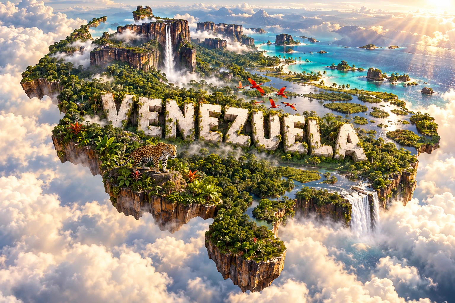
Venezuela is a northern South American country where the Andes, Caribbean coast, seasonally flooded plains and ancient Guiana Highlands meet. The Orinoco and its tributaries connect much of this varied landscape, while isolated tepui plateaus support distinctive habitats and immense waterfalls. Oil transformed Venezuela's cities and economy, but geography, Indigenous knowledge, farming, fishing and regional cultures remain essential to understanding the country.
1. Where Is Venezuela?
Venezuela occupies the northern edge of South America. It faces the Caribbean Sea and Atlantic Ocean, giving it a long coast and numerous offshore islands. Colombia borders it to the west and southwest, Brazil to the south, and Guyana to the east. Trinidad and Tobago lies just offshore across the Gulf of Paria.
Caracas, the capital, sits in a mountain valley near—but not directly on—the Caribbean coast. Venezuela administers territory west of the Essequibo River, while claiming the much larger Guayana Esequiba region administered by Guyana. The validity of the 1899 boundary award is before the International Court of Justice. Educational maps should distinguish present administration from the unresolved claim rather than imply that the dispute is settled.
2. Quick Country Facts
| Fact | Detail |
|---|---|
| Official name | Bolivarian Republic of Venezuela |
| Capital | Caracas |
| Continent | South America |
| Area | About 916,000 square kilometres using the commonly reported national figure; territorial claims complicate totals |
| Population | About 28.5 million in the World Bank's 2025 estimate |
| Currency | Bolívar; currency arrangements and usage can change |
| Official language | Spanish; Indigenous languages also have official status for Indigenous peoples |
| Time zone | UTC−4 |
| Highest point | Pico Bolívar, about 4,978 metres |
| Major river | Orinoco |
| Coast | Caribbean Sea and Atlantic Ocean |
Population and economic figures are time-sensitive, especially because Venezuela has experienced large migration flows and rapid economic change.
3. Geography and Landscape
Venezuela can be understood through four broad physical regions. In the northwest, the Venezuelan Andes rise as an extension of the great Andean system. High ridges, valleys and páramo grasslands surround cities such as Mérida. Separate coastal ranges run near the Caribbean and enclose the Caracas valley.
Across the centre stretch the Llanos, enormous plains shared with Colombia. Rivers spill across these lowlands during the rainy season, creating wetlands and flooded savannas; in the dry season, water retreats and grasslands dominate. Cattle ranching, wildlife and seasonal transport all respond to this water cycle.
South of the Orinoco lie the Guiana Highlands, underlain by very old rocks. Towering tablelands called tepuis rise above forest and savanna. Auyán-tepui is the source of Kerepakupai Vená, widely known as Angel Falls. Farther south and east are extensive forests, rivers and uplands adjoining Brazil and Guyana.
The north includes the Maracaibo Basin, Caribbean lowlands, deltas and islands. Lake Maracaibo is a large brackish tidal lake or inlet connected to the Caribbean; terminology varies because of that connection. The Orinoco divides into many channels before reaching the Atlantic, building a vast delta of wetlands and mangroves.
4. Why Does Venezuela Look Like This?
Different geological histories created Venezuela's contrasting regions. Along the north and west, interactions among the Caribbean and South American plates compressed, faulted and uplifted crust. Those movements helped form the Andes and Caribbean coastal ranges and still generate earthquakes.
The Guiana Shield has a much older story. Its rocks formed in Precambrian time, long before the Andes. Over hundreds of millions of years, weathering and erosion removed weaker material while resistant sandstone remained as isolated plateaus. Tepuis are therefore erosional remnants, not flat-topped volcanoes. Their cliffs separate summit habitats from surrounding lowlands.
Water completes the picture. The Andes and Guiana Highlands feed the Orinoco system. On the Llanos, extremely gentle slopes slow drainage, so seasonal rain spreads over broad areas. In the Orinoco Delta, river sediment accumulates where fresh water meets tides and the Atlantic. Along the Caribbean, waves, currents, coral growth and changes in sea level shape beaches, lagoons and islands.
Angel Falls exists because water runs from a high tepui surface over a near-vertical cliff. Its total height is commonly given as 979 metres, including a very long uninterrupted drop, but measurements and definitions of waterfall segments differ among sources.
5. Climate
Most of Venezuela lies in the tropics, so rainfall and elevation often matter more than the calendar seasons. Temperatures remain hot in coastal lowlands, the Llanos, Amazonian forests and the Orinoco Delta. Mountain temperatures decrease with altitude, producing cooler valleys, cloud forests and cold páramo near the highest peaks.
Many regions have a wetter period roughly from May to November and a drier period from December to April, but timing and rainfall totals vary. The Guiana Highlands and southern forests are generally humid, while parts of the northwest—including the Paraguaná Peninsula and areas near Coro—are much drier and support thorn scrub or dunes.
The Intertropical Convergence Zone shifts north and south during the year, helping control tropical rainfall. Mountains force moist air upward, creating wet windward slopes and drier rain-shadow areas. El Niño and La Niña can contribute to drought or unusually heavy rain. Caribbean storms can affect the coast, although Venezuela lies south of the most frequently travelled Atlantic hurricane routes.
6. Wildlife and Ecosystems
Venezuela contains Caribbean marine habitats, mangroves, dry forest, cloud forest, páramo, flooded savanna, rainforest and tepui summits. This range supports high biodiversity, but species are not evenly distributed.
Jaguars inhabit suitable forest, wetland and savanna mosaics, particularly where prey and connected habitat remain; they do not roam every part of the country. Llanos waterways support capybaras, spectacled caimans, anacondas, river turtles and many waterbirds. Scarlet ibises are strongly associated with coastal mangroves and the Orinoco Delta rather than high mountains or all national wetlands.
The Orinoco crocodile is critically endangered and survives in limited river systems. Giant otters, manatees and river dolphins occur in suitable freshwater habitats. In the Andes, the spectacled bear occupies forest and páramo landscapes. Tepui summits contain highly localized frogs, plants and invertebrates; isolation has encouraged endemism, meaning that some species exist nowhere else.
Threats include habitat conversion, fire, hunting, pollution, illegal wildlife trade and mining impacts. Climate change may alter high-elevation and freshwater habitats. National parks and other protected areas are important, but boundaries alone cannot prevent damage without monitoring, enforcement and cooperation with resident and Indigenous communities.
7. Famous Landmarks and Natural Features
Canaima National Park protects about three million hectares in southeastern Venezuela. UNESCO recognizes its exceptional tepui landscape, cliffs, forests, savannas and waterfalls. The park is also homeland to Pemón communities; it should not be described as empty wilderness.
Kerepakupai Vená (Angel Falls) descends from Auyán-tepui and is widely recognized as the world's highest waterfall by total height. Its Indigenous name and setting are as important as the superlative.
Mount Roraima is a tepui at the meeting area of Venezuela, Guyana and Brazil. Its summit landscape illustrates erosion, isolation and specialized ecology; it does not belong exclusively to one country.
Mérida and the Venezuelan Andes show the country's high-mountain geography. Pico Bolívar is the highest peak, while nearby páramo ecosystems store and release water.
Coro and its Port preserve earthen architecture shaped by Indigenous, Spanish and Dutch Caribbean influences. UNESCO placed the property on the List of World Heritage in Danger in 2005 because of conservation threats, including damaging rain and development pressures.
Ciudad Universitaria de Caracas, designed principally by Carlos Raúl Villanueva, integrates modern architecture, art and landscape. Los Roques Archipelago represents a contrasting Caribbean environment of coral reefs, seagrass, mangroves, sandy cays and lagoons.
8. People, Languages and Culture
Most Venezuelans live in northern cities and valleys rather than the sparsely populated interior. Spanish is the dominant language, but the constitution recognizes Indigenous languages for Indigenous peoples. Communities include Pemón, Warao, Wayuu, Ye'kwana, Yanomami and many others, each with distinct territories, languages and traditions. These identities should not be collapsed into one “Indigenous culture.”
Venezuelan society reflects Indigenous, European, African, Caribbean, Middle Eastern and other histories. Spanish colonization began in the sixteenth century; forced African labour and Indigenous dispossession shaped the colonial period. Independence was declared in 1811 and secured through wider wars that transformed northern South America. Simón Bolívar, born in Caracas, became a leading figure in those struggles.
Regional music includes joropo, associated especially with the Llanos and featuring harp or bandola, cuatro and maracas. On the Caribbean coast, drumming traditions reflect strong African heritage. Gaita zuliana is associated with Zulia and the Christmas season, while musical practice varies widely across regions and generations.
Baseball has a large following, alongside football, basketball and traditional games. Religious life includes Catholic and Protestant Christianity, Indigenous spiritual traditions and other beliefs. Urban art, literature, theatre and contemporary music coexist with local festivals, craft traditions and oral histories.
9. Food
Arepas are maize cakes split or topped with many fillings. They are eaten in varied forms across Venezuela and are also deeply rooted in Colombia, so neither country's tradition should be erased. Pabellón criollo commonly combines shredded beef, black beans, rice and fried plantain.
Hallacas wrap seasoned maize dough and a complex filling in plantain leaves, especially for Christmas gatherings. Recipes differ by family and region. Cachapas are soft cakes made from fresh maize, often served with cheese. Along coasts and rivers, fish is important; in the Andes, wheat, potatoes and cooler-climate foods are more prominent; cassava has long been central in many Indigenous food systems.
Food availability and eating patterns have also been affected by recent economic hardship and migration. A respectful account recognizes celebrated dishes without suggesting that every household has equal access to them or follows one national menu.
10. Economy and Major Industries
Petroleum has shaped Venezuela's modern economy more than any other industry. The country possesses very large oil resources, including heavy crude in the Orinoco Belt. Oil exports financed urban growth, infrastructure and government spending, but dependence on one volatile commodity also made the economy vulnerable to price changes, production problems and policy decisions.
Natural gas, petrochemicals, refining, iron ore, steel, gold and other minerals are significant. Hydroelectric plants on the Caroní River have supplied much of the country's electricity. Mining can create income but also threatens forests, rivers and Indigenous territories when poorly regulated or illegal.
Agriculture produces maize, rice, sugar cane, coffee, cocoa, fruit and livestock, though domestic production and imports have shifted over time. Manufacturing, construction, retail, transport, communications and other services support cities. Fisheries operate in Caribbean, Atlantic and inland waters.
The country has experienced a prolonged economic and humanitarian crisis, high inflation, disrupted services and large-scale emigration. Because conditions and measurements change quickly—and some datasets contain long gaps—educational pages should date economic statistics and avoid presenting estimates as settled facts.
11. What the 3D Visual Represents
The Venezuela artwork combines a very high waterfall inspired by Kerepakupai Vená, sandstone tepuis, Caribbean coast, Orinoco wetlands, rainforest, scarlet ibises and a jaguar. These elements represent distinct regions: Guiana Highland geology, northern marine landscapes, the great river system, tropical ecosystems and localized wildlife.
The image is a conceptual artistic composition. The waterfall, tepuis, coast, wetlands, forest and animals are combined for educational visualization and are not shown at their true geographic positions or scale. Scarlet ibises are especially linked to coastal and delta wetlands, while jaguars depend on suitable connected habitat; neither occurs uniformly nationwide. The artwork is not a satellite map or a depiction of the disputed boundary.
12. Interesting Facts About Venezuela
- Venezuela has both a Caribbean and an Atlantic coastline.
- The country contains Andes, plains, ancient highlands, rainforests, deltas and dry scrub.
- The Orinoco is one of South America's great river systems.
- The Llanos flood seasonally because heavy rain spreads across very gentle slopes.
- Tepuis are erosion-resistant plateau remnants, not volcanoes.
- Kerepakupai Vená is widely listed as the world's highest waterfall by total height.
- Canaima National Park covers about three million hectares.
- Mount Roraima lies at the meeting area of Venezuela, Guyana and Brazil.
- Lake Maracaibo is connected to the Caribbean, so it is sometimes described as a tidal bay or inlet rather than a conventional lake.
- Pico Bolívar is Venezuela's highest mountain.
- Spanish and numerous Indigenous languages have official constitutional recognition in their respective contexts.
- Joropo developed strongly in the plains shared by Venezuela and Colombia.
- Venezuela has three UNESCO World Heritage properties.
- Coro and its Port remains on UNESCO's List of World Heritage in Danger.
- The Essequibo boundary issue remains under international legal proceedings and should not be shown as settled.
13. Short Quiz
-
Which river system drains much of Venezuela? A. Paraná B. Orinoco C. Mississippi D. Danube
-
What are tepuis? A. Coral islands B. Active ice volcanoes C. Isolated table-top plateaus shaped by erosion D. Artificial reservoirs
-
Why do the Llanos flood seasonally? A. Glaciers melt across the plains B. Rain spreads over low-gradient land C. Ocean tides cover the entire interior D. Volcanoes block every river
-
Which animal in the visual is particularly associated with coastal and delta wetlands? A. Scarlet ibis B. Spectacled bear C. Condor D. Llama
-
Why is the artwork not a literal map? A. Venezuela has no rivers B. It combines distant features and wildlife at invented positions and scales C. The country is an island D. All tepuis are in Caracas
Answer key: 1-B, 2-C, 3-B, 4-A, 5-B.
14. Related Learning
- Colombia Explained: Shared Andes, Llanos and cultural connections
- Guyana Explained: The Guiana Shield and Essequibo context
- Brazil Explained: Amazon watersheds and the Guiana Highlands
- Trinidad and Tobago Explained: Islands beside Venezuela's coast
- Why Tepui Mountains Have Flat Tops
- How the Orinoco River Shapes Venezuela
- Why the Llanos Flood Every Year
- How Angel Falls Formed
- Why Lake Maracaibo Has So Much Lightning
- How Páramo Ecosystems Store Water
These are internal-link topics or article-title suggestions. Confirm that a page exists before assigning a URL.
15. Sources
- World Bank Data — Venezuela
- UN Data — Venezuela country profile
- UNESCO World Heritage Centre — Venezuela
- UNESCO — Canaima National Park
- UNESCO — Coro and its Port
- UNESCO — Ciudad Universitaria de Caracas
- International Court of Justice — Arbitral Award of 3 October 1899
- FAO — Venezuela country profile
- Convention on Biological Diversity — Venezuela profile
- Ramsar Convention — Venezuela country profile
- Encyclopaedia Britannica — Venezuela
- Encyclopaedia Britannica — Orinoco River
- USGS — Caribbean and South American plate tectonics
- IUCN Red List — Orinoco crocodile