

Timor-Leste is a young country on an ancient and geologically active island. Steep mountains rise close to the sea, short rivers flood during the wet season and dry rapidly afterward, while coral reefs descend into deep waters around the coast.
Its geography reflects the collision of the Australian continent with the Banda island arc—not the construction of one giant volcano. Coffee grows in cooler uplands, most farming depends on seasonal rain, and villages, languages and woven textiles vary across a small but rugged territory. Timor-Leste’s modern independence was restored in 2002 after centuries of colonial rule, occupation and resistance.
1. Where Is Timor-Leste?
Timor-Leste lies in Maritime Southeast Asia at the eastern end of the Lesser Sunda Islands. It occupies the eastern part of Timor island. Indonesia’s province of East Nusa Tenggara occupies the western part.
The country also includes Oecusse-Ambeno, an enclave on Timor’s northwestern coast surrounded on land by Indonesia, plus Atauro Island north of Dili and Jaco Island off the eastern tip. This makes its territory discontinuous rather than one simple eastern block.
The Timor Sea separates the country from Australia to the south. To the north lie the Banda and Wetar seas and other Indonesian islands. Deep channels around the region connect the Pacific and Indian oceans through the Indonesian Throughflow.
Dili, the capital and largest city, lies on the dry north coast between mountains and the sea. Baucau is the second-largest urban center. Other important towns include Maliana, Suai, Same, Lospalos, Ermera, Viqueque and Pante Macassar in Oecusse.
Timor-Leste joined the World Trade Organization in 2024 and became a member of ASEAN in 2025, deepening its links with Southeast Asian neighbors.
2. Quick Country Facts
- Official name: Democratic Republic of Timor-Leste
- Capital: Dili
- Region: Maritime Southeast Asia
- Area: Approximately 15,007 square kilometres according to the government
- Population: 1,341,737 usual residents in the 2022 census
- Currency: United States dollar; Timor-Leste also issues centavo coins
- Official languages: Tetum and Portuguese
- Working languages: Indonesian and English under the Constitution
- Other languages: More than a dozen Timorese languages, including Mambai, Makasae, Bunak and Fataluku
- Time zone: Timor-Leste Time, UTC+9, year-round
- Highest point: Mount Ramelau, or Tatamailau, approximately 2,963 metres
- Major island components: Eastern Timor, Oecusse, Atauro and Jaco
- Independence restored: 20 May 2002
- World Heritage: No inscribed UNESCO properties or Tentative List sites as of September 2026
Area totals differ slightly among official and international datasets because of measurement conventions. The source and date should accompany precise statistics.
3. Geography and Landscape
A central mountain spine runs through Timor-Leste from southwest to northeast. Peaks, ridges and steep-sided valleys occupy most of the land, leaving narrow coastal plains. Mount Ramelau is the highest summit, while Matebian is another prominent mountain with cultural and historical importance.
The north coast is generally drier, narrower and more rugged. Dili stands where small river fans create limited flat land. The south coast has broader plains in places, larger wetlands and heavier seasonal rainfall, but roads and rivers can become difficult during the wet season.
Most rivers are short and steep. They are often reduced to shallow channels in the dry season, then become powerful, sediment-filled torrents during heavy rain. The Laclo, Loes, Seiçal and other systems support farms and settlements but are not large permanently navigable rivers.
The limestone Baucau Plateau rises above the north coast, with caves, springs and terraces. Elsewhere, folded marine rocks, uplifted coral limestone, clay-rich slopes and river deposits create complicated soils and landforms.
Atauro Island is mountainous and separated from Dili by the Wetar Strait. Jaco is a small, uninhabited island at the eastern end, beside Tutuala and within Nino Konis Santana National Park. Oecusse combines coast, hills and river valleys west of the main international boundary.
Coral reefs, seagrass, mangroves and deep offshore waters surround much of the country. Timor-Leste lies within the Coral Triangle, a global center of marine biodiversity, though reef condition varies with fishing, sediment, heat and development.
4. Why Does Timor-Leste Look Like This?
Timor lies where the north-moving Australian Plate meets the Banda Arc. The Australian continental margin began colliding with the arc several million years ago, compressing, folding and thrusting seafloor sediment and older rock upward.
That process explains why marine limestone and fossils occur high above today’s sea. Timor is largely an uplifted collision landscape, unlike nearby islands built primarily by active volcanoes. There are no large active volcanoes in Timor-Leste itself.
Uplift continues while rivers cut downward, creating steep relief and deeply incised valleys. Earthquakes occur because plate movement remains active. Offshore earthquakes can also generate tsunamis, making coastal preparedness important.
Rock is fractured and slopes are steep, so intense rain readily triggers landslides, erosion and debris flows. Rivers carry large sediment loads to the coast, where muddy plumes can damage coral. Deforestation, burning, roads and cultivation on vulnerable slopes can accelerate this natural erosion.
Coral reefs grow where light, temperature and water quality are suitable. Tectonic uplift has raised older reefs into limestone terraces, while living reefs fringe parts of the modern coast. Deep water lies unusually close to Atauro because tectonic basins and straits separate the islands.
The mountains also divide climate. Moist monsoon air rises over slopes and releases rain, with the south generally wetter than the north. Elevation creates cooler uplands suitable for coffee and montane forest even though the coast is tropical.
5. Climate
Timor-Leste has a tropical monsoon climate with marked wet and dry seasons. Much of the country receives most rain from roughly November or December through April, while May to October is drier. Timing and totals vary by elevation and exposure.
The north coast is comparatively dry and has a long dry season. Southern slopes and coastal plains receive more rain and may have a shorter mid-year dry period. Mountain zones are cooler and can collect cloud and mist.
Rain often falls in intense bursts. Flash floods can cross roads, erode fields and damage homes, while saturated slopes fail in landslides. Tropical Cyclone Seroja in April 2021 demonstrated how extreme rain and floods can devastate Dili and other communities even though direct cyclone landfalls are uncommon.
During El Niño years, rainfall may be delayed or reduced, worsening drought, crop losses and water shortages. La Niña can increase heavy-rain risk. Because most smallholder farming is rain-fed, the onset and distribution of rain matter as much as the annual total.
Climate change is increasing heat and sea-level risk and may intensify rainfall variability. Healthy watersheds, rainwater storage, drought-tolerant crops, early warning and flood-safe roads are essential adaptations.
6. Wildlife and Ecosystems
Timor-Leste contains dry tropical forest, moist mountain forest, savanna, grassland, wetlands, mangroves, seagrass beds and coral reefs. Much original forest has been altered by farming, fire, fuelwood collection and grazing, but important habitat survives in the east, mountains and community-managed areas.
The island’s wildlife reflects both Asian and Australasian connections. Endemic and restricted-range birds include the Timor green pigeon, Timor imperial pigeon, Timor sparrow and iris lorikeet. The endangered yellow-crested cockatoo survives in limited habitat and is threatened by forest loss and trapping.
Saltwater crocodiles inhabit some rivers, estuaries and coasts. They hold powerful cultural meaning in Timorese origin traditions but can also kill people; respect for symbolism should never replace practical safety. Timor deer, cuscuses, bats and small mammals occur in suitable habitats, with some species introduced long ago.
Offshore waters lie along migration routes for whales and dolphins. Dugongs use particular seagrass habitats, and sea turtles nest on some beaches. Atauro’s reefs are exceptionally diverse, but biodiversity varies among sites and should not be converted into an unsupported world ranking.
Nino Konis Santana National Park protects terrestrial and marine habitat around the eastern tip, including Jaco Island and areas important to Fataluku communities. Conservation must recognize customary ownership and tara bandu, locally grounded rules that can regulate harvesting and protect resources.
Threats include destructive fishing, plastic waste, sediment from eroding watersheds, coral bleaching, hunting and forest clearing. Healthy uplands and reefs are connected: soil retained on farms is soil that does not smother coral.
7. Famous Landmarks and Natural Features
- Mount Ramelau/Tatamailau: The country’s highest mountain is a pilgrimage destination and watershed with grassland, forest remnants and expansive views.
- Atauro Island: Mountainous terrain and deep surrounding waters support coral reefs, fishing communities and several local languages and traditions.
- Jaco Island and Valu Beach: The island and adjacent coast lie within Nino Konis Santana National Park and have cultural restrictions as well as ecological value.
- Matebian: This prominent eastern massif is sacred to local communities and contains sites connected to resistance and civilian refuge during the Indonesian occupation.
- Cristo Rei of Dili: The hilltop statue and coastal headland are recognizable landmarks, but the monument originated during Indonesian rule and has a layered political meaning.
- Resistance Museum: Located in Dili, the museum documents the struggle against Indonesian occupation through archives and personal histories.
- Baucau old town: Springs, Portuguese-period buildings and limestone terraces illustrate colonial urban layers within a living Timorese city.
- Balibo Fort: The reconstructed fort is linked both to older colonial history and to five journalists killed during the 1975 Indonesian advance.
- Lake Ira Lalaro: This seasonal karst lake and wetland in the east changes size and supports birds, reptiles and local livelihoods.
Timor-Leste has no UNESCO World Heritage property yet. National importance should not be confused with inscription, and UNESCO is supporting development of the country’s first Tentative List.
8. People, Languages and Culture
Timor-Leste’s people belong to communities with Austronesian and Papuan-language histories. Tetum is widely spoken and serves as an official language, but forms vary; Tetum Prasa, centered on Dili, includes substantial Portuguese vocabulary. Portuguese is the other official language.
Mambai, Makasae, Kemak, Bunak, Fataluku, Baikeno and many other languages have strong regional importance. Bunak and Fataluku belong to Papuan-language families, while many others are Austronesian. Indonesian and English remain working languages and are common among particular generations and professions.
Most residents are Roman Catholic, reflecting Portuguese rule and the church’s role during occupation. Older beliefs and rituals concerning ancestors, sacred houses and land often coexist with Christianity. Lulik, commonly translated as sacred or forbidden, describes relationships and obligations more complex than a single religion label.
Tais are handwoven textiles whose colors, motifs and methods identify regions, communities and occasions. They are used in ceremony, exchange, clothing and public symbolism. A generic tais-like pattern in an illustration cannot accurately represent every municipality.
Sacred houses, or uma lulik, embody ancestry and social relationships, but architecture differs regionally. Music and dance feature gongs, drums, guitars, oral poetry and local forms. Cultural practice has continued to change through migration, education and urban life.
Portuguese involvement began in the sixteenth century. Colonial control remained uneven for centuries, and the modern border with Dutch-controlled western Timor was settled through European agreements. Japan occupied the island during World War II, causing devastating civilian losses.
After Portugal’s 1974 revolution, political transition accelerated. Timor-Leste declared independence on 28 November 1975; Indonesia invaded on 7 December and occupied the territory. Conflict, famine and repression caused immense loss of life.
In a UN-sponsored referendum on 30 August 1999, an overwhelming majority voted to reject autonomy within Indonesia. Militias destroyed infrastructure and displaced people after the result. A UN administration followed, and sovereignty was restored on 20 May 2002. Reconciliation and justice remain distinct, unfinished processes.
9. Food
Maize, rice, cassava, sweet potato and taro are major staples, with importance changing by place and season. Batar da’an combines maize, mung beans and pumpkin or other vegetables into a nourishing everyday dish.
Fish is central in coastal communities and may be grilled or cooked with tamarind, chili and local herbs. Ikan sabuko is commonly described as fish flavored with tamarind, basil and spices. Chicken, pork, buffalo and goat are eaten according to household resources and ceremony.
Leafy greens, beans, peanuts, bananas, papaya, coconut and breadfruit add variety. Food shortages during the pre-harvest “hungry season” remain a serious problem for some rural households, so cuisine should not be romanticized without acknowledging access and nutrition.
Coffee is a beverage and vital cash crop rather than a staple food. Timorese coffee often grows beneath shade trees in uplands, especially Ermera, Aileu, Ainaro and Liquiça, linking farm income to forest and soil management.
10. Economy and Major Industries
Public spending financed by petroleum savings dominates economic activity. Offshore oil and gas from the Bayu-Undan field generated large revenues that were invested in the Petroleum Fund. Production ended in 2025, making careful management of the remaining fund especially important.
The proposed Greater Sunrise gas development straddles the maritime boundary with Australia. Its route, cost and timing remain policy questions rather than guaranteed future income. Petroleum wealth has funded roads and services but created dependence on state expenditure and imports.
Agriculture, livestock, forestry and small-scale fisheries support most rural livelihoods. Farmers grow maize, rice, cassava, vegetables and fruit. Productivity is constrained by small plots, erosion, irregular rain, limited irrigation, storage and market access.
Coffee is the leading non-petroleum merchandise export and an important source of household cash. Improving plant health, processing, quality, transport and farmer bargaining power can add value without replacing food crops or forest shade.
Services include government, construction, retail, transport, telecommunications and hospitality. Tourism remains small but draws on reefs, mountains, history and culture. It requires local skills, reliable transport, waste management and protection of community rights.
The United States dollar provides monetary stability but removes an independent exchange-rate tool. WTO accession in 2024 and ASEAN membership in 2025 expand regional opportunities, yet competitiveness depends on education, electricity, ports, land administration and productive private businesses.
The durable economic challenge is converting finite petroleum savings into health, knowledge, infrastructure and diversified jobs without exhausting the fund. Current depletion forecasts vary with spending, investment returns and future projects.
11. What the 3D Visual Represents
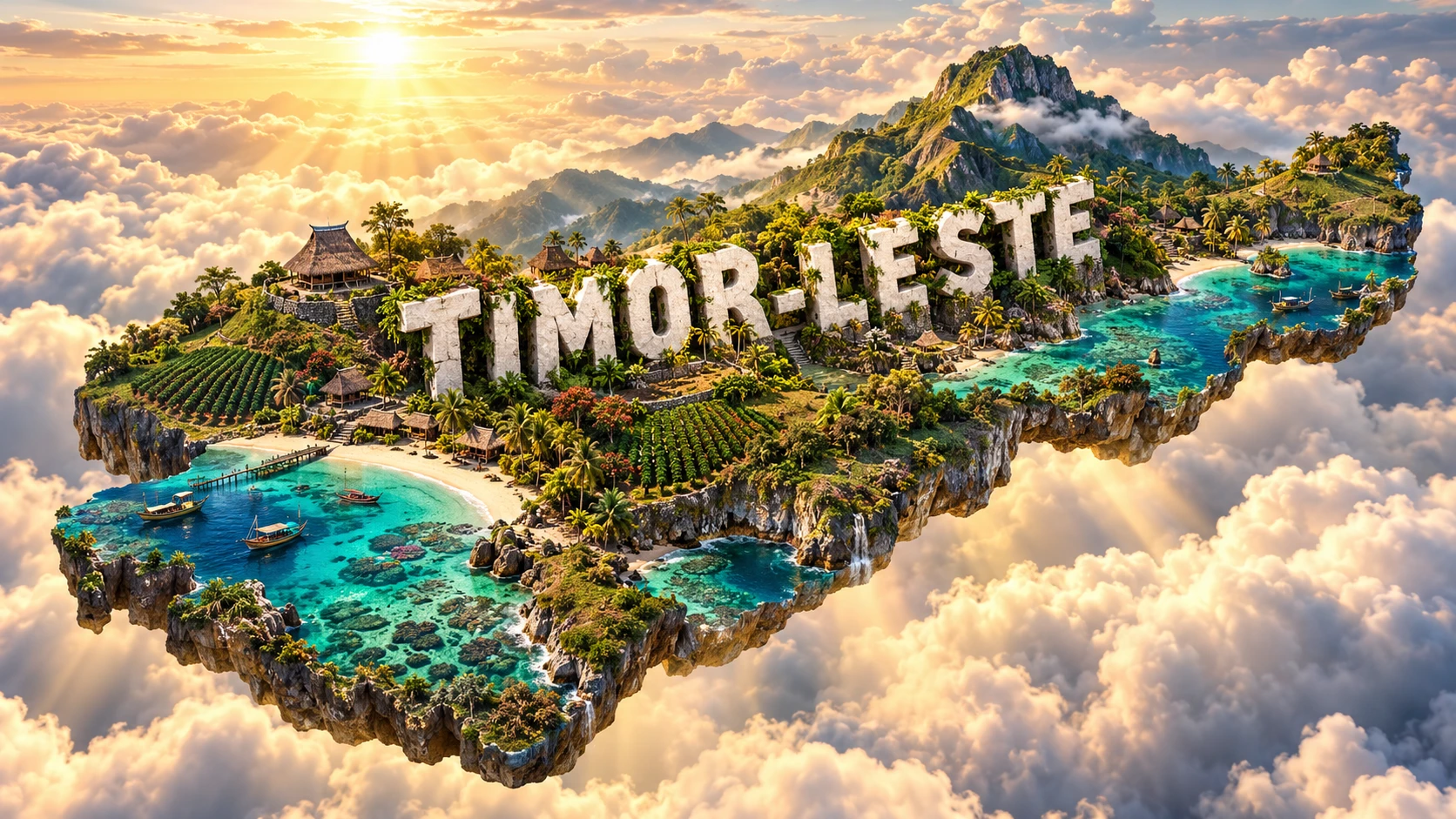
The Timor-Leste artwork combines rugged mountains, beaches, coral reefs, traditional village forms, coffee plantations, fishing boats and tais-inspired textile motifs. These symbolize tectonic uplift, coastal biodiversity, rural livelihoods, upland exports, maritime food systems and regional weaving traditions. The “TIMOR-LESTE” lettering is decorative typography.
The elements occupy different settings. Coffee grows mainly in cooler uplands; reefs vary around the coast; fishing methods differ by community; and village architecture and tais patterns have local meanings. “Pristine” beaches can still face erosion, waste, fishing pressure or customary-use rules.
The image is a conceptual artistic composition. The landmarks, wildlife and landscapes are combined for educational visualization and are not shown at their true geographic positions or scale. It is a floating micro-world, not a satellite map or claim that one textile motif represents every Timorese community.
12. Interesting Facts About Timor-Leste
- Timor-Leste occupies eastern Timor but also includes the western Oecusse enclave.
- Atauro and Jaco are part of the national territory.
- Mount Ramelau is the highest point at approximately 2,963 metres.
- Timor’s mountains formed mainly through continental collision and uplift, not one large volcano.
- Marine limestone occurs high in the mountains because former seabed was uplifted.
- Short rivers can change from dry-season channels to destructive wet-season torrents.
- Tetum and Portuguese are the two official languages.
- Timor-Leste uses the United States dollar and issues its own centavo coins.
- Tais weaving traditions vary by region and community.
- Coffee is the principal non-petroleum merchandise export.
- Timor-Leste declared independence in 1975 and restored it in 2002.
- The 1999 referendum rejected continued integration with Indonesia.
- The country joined the World Trade Organization in 2024.
- It joined ASEAN in 2025.
- Timor-Leste had no UNESCO World Heritage properties as of September 2026.
13. Short Quiz
-
Why is Timor-Leste so mountainous? A. Collision uplifted and folded rocks at the Australian–Banda boundary B. One modern volcano built the entire country C. Coral grows into mountains each year D. Wind piled up desert sand
-
What makes Oecusse unusual? A. It is an enclave separated from the main territory by Indonesia B. It is the highest summit C. It floats south of Australia D. It is an artificial reservoir
-
Which crop is the leading non-petroleum merchandise export? A. Coffee B. Wheat C. Apples D. Cotton
-
When was Timor-Leste’s sovereignty restored? A. 20 May 2002 B. 1 January 1900 C. 7 December 1975 D. 30 August 1999
-
Why is the 3D artwork conceptual? A. It combines separated uplands, coasts, livelihoods and regional motifs B. Every village uses one identical textile C. It is a measured satellite image D. Coffee grows naturally on every beach
Answer key: 1-A, 2-A, 3-A, 4-A, 5-A
14. Related Learning
- Indonesia Explained: Shared Timor Island and the Banda Arc
- Australia Explained: The Continental Plate South of Timor
- How Plate Collision Built Timor-Leste’s Mountains
- Why Timor-Leste Has Marine Rocks High Above the Sea
- How Monsoons Shape Farming in Timor-Leste
- Why Atauro Has Such Diverse Coral Reefs
- How Coffee Grows Under Shade in Timor-Leste
- What Tais Textiles Communicate
- How the 1999 Referendum Led to Restored Independence
- Why Timor-Leste Must Diversify Beyond Petroleum
15. Sources
- Government of Timor-Leste — country profile
- Timor-Leste Population and Housing Census 2022
- Government of Timor-Leste — ASEAN media guide and geography
- World Bank — Timor-Leste overview
- World Bank — Timor-Leste Economic Reports
- FAO — Timor-Leste at a glance
- FAO GIEWS — Timor-Leste country brief
- UNESCO — Timor-Leste World Heritage status
- UNESCO — Developing Timor-Leste’s first Tentative List
- Convention on Biological Diversity — Timor-Leste country profile
- UNDP — Timor-Leste country information
- United Nations — Timor-Leste member-state profile
- International Court of Justice — Timor-Leste and Australia maritime arrangements
- Encyclopaedia Britannica — East Timor