

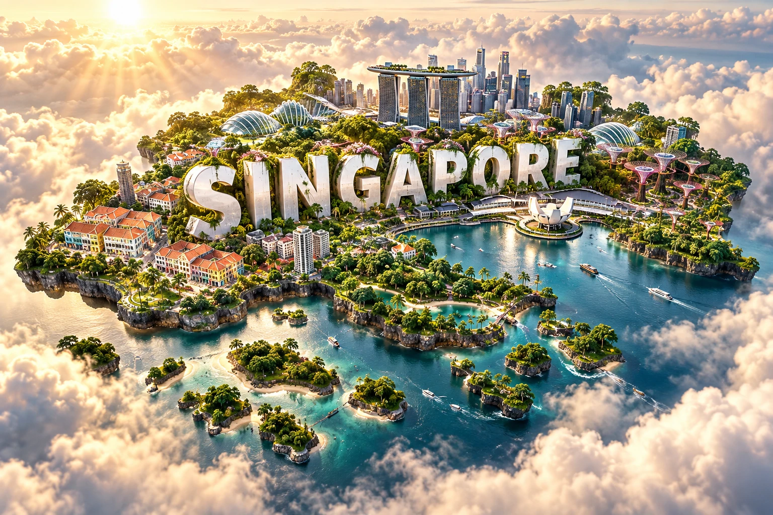
Singapore is a densely populated island city-state near the southern tip of the Malay Peninsula. Its location beside the Strait of Malacca helped make it a global port, but its modern landscape also depends on extensive engineering: coastlines have been reclaimed, rivers dammed into reservoirs, drainage redesigned and greenery woven through high-density neighborhoods.
Beneath the skyline is an equatorial landscape of low hills, granite, sedimentary rock, mangroves and reefs. Small remnants of primary forest protect remarkable biodiversity, while restored wetlands and urban corridors show both the possibilities and limits of conserving nature in a highly transformed country.
1. Where Is Singapore?
Singapore lies in maritime Southeast Asia, about one degree north of the Equator. The Johor Strait separates it from Peninsular Malaysia to the north, while the Singapore Strait separates it from Indonesia's Riau Islands to the south.
The country consists of the main island, Pulau Ujong, and more than 60 smaller islands and islets. Two land links—the Johor–Singapore Causeway and the Second Link—connect the main island to Malaysia. There is no natural land border.
Singapore sits near the eastern entrance to the Strait of Malacca, one of the world's busiest shipping corridors. Vessels traveling between the Indian Ocean, South China Sea and Pacific routes pass nearby, helping explain the country's long importance as a trading port.
The city and country share the name Singapore. The historic civic and commercial center lies near the Singapore River and Marina Bay, but housing towns, industrial estates, reservoirs, airports, ports and nature reserves occupy the wider island.
2. Quick Country Facts
- Official name: Republic of Singapore
- Capital: Singapore
- Region: Southeast Asia
- Land area: Approximately 736 square kilometres; reclamation changes the figure over time
- Total population: 6.11 million at the end of June 2025
- Resident population: 4.20 million in June 2025
- Currency: Singapore dollar (SGD)
- Official languages: English, Malay, Mandarin Chinese and Tamil
- National language: Malay
- Time zone: Singapore Standard Time, UTC+8, year-round
- Highest natural point: Bukit Timah Hill, approximately 163 metres
- Government: Parliamentary republic
- Independence: 9 August 1965
- World Heritage: Singapore Botanic Gardens
The total population includes citizens, permanent residents and non-residents such as many workers, students and family members. Resident and citizen totals answer different questions and should not be substituted for one another.
3. Geography and Landscape
Singapore is low-lying and gently undulating. Its central and northwestern hills contrast with flatter eastern and coastal areas. Bukit Timah Hill is modest in global terms but forms the highest point within a compact island where elevation strongly affects drainage.
Three broad geological zones shape the main island. The Bukit Timah Granite underlies much of the center and north. Sedimentary rocks of the Jurong Formation occur mainly in the west and southwest. Younger alluvium, marine clay and reclaimed material cover eastern and coastal lowlands.
No long natural river crosses Singapore. Short streams once drained into mangrove-fringed estuaries, but many have been canalized or incorporated into reservoirs and stormwater systems. The Singapore and Kallang rivers now flow into Marina Reservoir behind Marina Barrage.
Coastal reclamation has enlarged and reshaped the country. Changi Airport, Tuas industrial and port areas, Marina Bay and parts of Jurong Island occupy reclaimed land. Offshore islands were joined, expanded or modified for industry, housing, defense, recreation and conservation.
Reclamation does not simply “create land from nothing.” Sand, rock, sea walls and engineered fill replace shallow marine habitat and alter currents and sediment. Singapore increasingly studies alternative fill methods and coastal defenses because imported sand, environmental effects and sea-level rise constrain future work.
Reservoirs, parks and roadside trees are conspicuous, but much greenery is planned or secondary vegetation. Bukit Timah and Central Catchment nature reserves retain important native forest. Sungei Buloh protects mangrove and mudflat habitat, while coral reefs survive mainly around southern islands.
4. Why Does Singapore Look Like This?
Singapore sits on the stable interior of the Sunda Plate rather than on the volcanic arcs of Indonesia. It has no active volcanoes, and damaging local earthquakes are rare. Tremors from large Sumatran earthquakes can sometimes be felt because seismic waves cross the region.
The Bukit Timah granite formed when magma cooled underground roughly 200 million years ago. Tropical weathering later decomposed minerals into thick soils, while resistant rock remained in hills. Western sedimentary and volcanic-derived layers were folded and faulted during older tectonic events.
During Ice Age periods, sea level was much lower and Singapore was connected to the broader Sunda landmass with Malaya, Sumatra, Java and Borneo. As ice melted, rising seas flooded lowlands and separated the island. This history helps explain ecological connections with the Malay Peninsula.
Rain and streams then shaped the low relief. Intense chemical weathering rounds rock and produces clay-rich soils. Rivers deposited sand and mud in valleys and estuaries, while tides built mangrove flats. Modern construction covers many surfaces, causing rain to run off quickly.
Urban engineering now shapes the landscape as strongly as geology. Drains and canals move stormwater; detention systems slow it; reservoirs store it; pumps protect some low areas. Marina Barrage blocks seawater, creates a freshwater reservoir and helps manage floods when tide and rainfall conditions permit.
Singapore's skyline reflects scarce land and planning choices rather than a naturally vertical landscape. High-rise housing and mixed-use centers concentrate people near transit, while zoning separates or buffers some industrial, residential, military and conservation areas.
5. Climate
Singapore has a hot, humid equatorial climate. Temperatures vary little by season, rainfall is abundant throughout the year and thunderstorms are frequent. The 1991–2020 average at Changi recorded about 2,113 millimetres of rain over roughly 171 rain days annually.
The Northeast Monsoon lasts from December to early March. Its wetter phase, especially November to January, can bring prolonged rain through monsoon surges. A drier phase often follows in February and early March.
The Southwest Monsoon, from June to September, has southeast to southwest winds and can bring early-morning Sumatra squalls—organized thunderstorm lines moving from Sumatra and the Strait of Malacca. Inter-monsoon periods around April–May and October–November often have light winds and intense afternoon storms.
There is no reliably rainless season. Local rainfall varies because thunderstorms are small and fast-changing. Dense buildings also create an urban heat-island effect, while trees, shade, ventilation and water can reduce heat locally.
Climate change raises average temperature, extreme-rainfall risk and sea level. Much infrastructure stands near the coast, so long-term adaptation includes higher platforms, drainage improvement, shoreline studies and possible barriers. These measures must avoid shifting flood or ecological impacts elsewhere.
6. Wildlife and Ecosystems
Singapore retains lowland rainforest, freshwater swamp, secondary woodland, mangrove, mudflat, rocky shore, seagrass and coral-reef habitats. They occupy small and often fragmented areas within an intensely urban region.
Bukit Timah Nature Reserve contains the country's largest contiguous tract of primary forest, while Central Catchment surrounds major reservoirs and holds larger secondary and swamp-forest areas. An ecological bridge over the Bukit Timah Expressway reconnects the two reserve systems for some plants and animals.
Native mammals include long-tailed macaques, Sunda colugos, lesser mouse-deer, smooth-coated otters and Sunda pangolins. Pangolins are Critically Endangered globally and face vehicle collisions and illegal trade. Wild boar and macaque encounters require secure food waste and distance rather than feeding.
Oriental pied hornbills have recovered after disappearing locally and returning naturally to Pulau Ubin, aided by nest boxes and habitat. Migratory shorebirds feed at Sungei Buloh's mudflats along the East Asian–Australasian Flyway. These species are linked to specific habitats, not every park.
Less than five percent of Singapore's nineteenth-century mangrove area remains, according to NParks. Southern reefs nevertheless support more than 250 recorded hard-coral species. Sediment, shipping, coastal works, warming and bleaching place these habitats under pressure.
Urban planting adds shade and movement routes, but a landscaped garden is not equivalent to old rainforest. Conservation requires protecting core habitat, controlling invasive species, reducing road deaths and maintaining connections as well as adding trees.
7. Famous Landmarks and Natural Features
- Marina Bay and Marina Barrage show how a tidal river mouth became a reservoir, flood-management structure and civic waterfront. The skyline around it was developed on heavily reshaped land.
- Singapore Botanic Gardens is the country's only World Heritage property. Founded at its present site in 1859, it helped research and distribute rubber cultivation across Southeast Asia and remains a scientific and conservation institution.
- Gardens by the Bay uses engineered conservatories, vertical “Supertree” structures and designed planting. It is a modern landscape project, not remnant rainforest.
- Bukit Timah Nature Reserve protects lowland dipterocarp forest and the island's 163-metre high point.
- Sungei Buloh Wetland Reserve conserves mangroves, mudflats and bird habitat in the northwest beside the Johor Strait.
- Pulau Ubin and Chek Jawa preserve village landscapes, secondary forest, quarries and an unusual meeting of rocky shore, mangrove, mudflat, seagrass and lagoon habitat.
- Civic District and Singapore River contain buildings and quays linked to colonial government and commerce, now adapted to new uses.
- Historic districts such as Chinatown, Kampong Gelam and Little India preserve places of worship, shophouses and community institutions. They are living, changing neighborhoods rather than complete containers for one ethnicity.
- Haw Par Villa uses elaborate sculptures to present stories from Chinese religion, mythology and ethics, illustrating another layer of twentieth-century popular culture.
8. People, Languages and Culture
Singapore's residents include citizens and migrants with Chinese, Malay, Indian, Eurasian and many other backgrounds. Official racial categories influence policy and statistics but do not capture every mixed identity, language practice or personal experience.
English is the main language of government, schooling and much business. Malay is the national language and is used in the national anthem and military commands. Mandarin and Tamil are official, while people also speak Malay varieties, Hokkien, Teochew, Cantonese, Punjabi, Bengali, Hindi and many other languages.
Singlish is an informal English variety shaped by Malay, Chinese languages, Tamil and local usage. Its grammar and particles communicate identity and nuance; it is not merely “bad English.” Speakers shift between Singlish and more formal English depending on context.
The island was known as Temasek in regional trading networks and had connections with Malay polities before European colonial rule. The British East India Company established a trading post in 1819 through agreements involving Stamford Raffles, Sultan Hussein Shah and Temenggong Abdul Rahman. Singapore became part of the Straits Settlements and drew migrants from across Asia.
Japan occupied Singapore from 1942 to 1945, a period of violence, deprivation and persecution, including the Sook Ching massacre. After British rule resumed, political organization expanded. Singapore gained full internal self-government in 1959, joined Malaysia in 1963 and became an independent republic after separation in 1965.
Rapid industrialization, mass public housing, universal education, national service and immigration transformed society. Most citizens now live in Housing and Development Board flats, which include markets, schools, transport and shared spaces rather than being only residential towers.
Buddhist, Muslim, Christian, Taoist, Hindu, Sikh and other institutions stand near one another, alongside nonreligious residents. Festivals include Hari Raya, Lunar New Year, Deepavali, Christmas and many community observances. Harmony is supported by law and institutions but still requires dialogue; diversity should not be portrayed as effortless or purely decorative.
9. Food
Hawker centers gather independently operated stalls serving affordable dishes in shared eating spaces. UNESCO recognized Singapore's hawker culture as intangible heritage in 2020, emphasizing community dining and knowledge passed through stallholders rather than one recipe.
Well-known foods include Hainanese chicken rice, Malay nasi lemak, Indian roti prata, fish-head curry and laksa. Their histories cross borders and communities. “Singaporean” versions developed through local ingredients, migration and adaptation, not isolated invention.
Chilli crab uses crab in a sweet-savory tomato and chili sauce. Kaya toast combines coconut-and-egg jam with toasted bread and is often eaten with coffee and eggs. Peranakan cuisines reflect long histories of Chinese communities in the Malay world and have varied regional forms.
Food security depends heavily on imports because local land is scarce. Diversified suppliers, storage and some high-tech production support resilience, while hawker succession, rents, nutrition and affordability remain continuing concerns.
10. Economy and Major Industries
Singapore is a high-income economy built around international trade, manufacturing and services. Its deepwater port is a leading transshipment hub, transferring containers between routes. Changi Airport supports passenger travel, air cargo and regional business.
Manufacturing remains important despite limited land. Major industries include semiconductors and electronics, pharmaceuticals and biotechnology, precision engineering, chemicals, refining and aerospace maintenance. Many plants occupy specialized estates such as Jurong Island.
Services include finance, insurance, logistics, information technology, professional services, education, healthcare and tourism. Singapore's legal, digital and transport systems help firms coordinate activity across Southeast Asia and beyond.
The economy depends on imported energy, food, materials and a large non-resident workforce. Global trade disruptions, aging among citizens, inequality and high costs create vulnerabilities. Productivity, skills and social support matter alongside headline national income.
Land and water scarcity shape investment. The Four National Taps are local catchment water, imported water from Johor, high-grade reclaimed NEWater and desalinated water. More than two-thirds of Singapore's land now serves as water catchment, but energy-intensive treatment brings environmental trade-offs.
Climate policy includes carbon pricing, solar deployment, greener buildings and research into low-carbon energy imports. Singapore's port, aviation and petrochemical sectors make deep decarbonization difficult, so targets depend on both domestic efficiency and regional energy systems.
11. What the 3D Visual Represents
The Singapore artwork combines a Marina Bay-inspired skyline, futuristic garden towers, tropical greenery, multicultural shophouses, waterfront architecture and dense urban gardens. These elements represent global commerce, high-density planning, Gardens by the Bay, historic neighborhoods, reclaimed waterfronts and long-running greening programs.
The image compresses different places and eras. Marina Bay is engineered and reclaimed; shophouses survive in protected districts rather than beneath every tower; nature reserves are biologically different from landscaped rooftops. The “SINGAPORE” letters are monumental graphic typography.
The image is a conceptual artistic composition. The landmarks, wildlife and landscapes are combined for educational visualization and are not shown at their true geographic positions or scale. It is a floating micro-world, not a satellite map, planning diagram or claim that all urban greenery is natural forest.
12. Interesting Facts About Singapore
- Singapore lies about one degree north of the Equator.
- Its territory includes a main island and more than 60 smaller islands and islets.
- The total population reached 6.11 million in June 2025.
- Bukit Timah Hill is only about 163 metres high.
- Reclamation has repeatedly changed the country's land area and coastline.
- Singapore has no long natural river.
- Marina Barrage turned a tidal channel into a freshwater reservoir.
- The country has four official languages, while Malay is the national language.
- It joined Malaysia in 1963 and became independent in 1965.
- Singapore Botanic Gardens is its only World Heritage property.
- Hawker culture is recognized as intangible cultural heritage.
- More than two-thirds of the island functions as water catchment.
- The Four National Taps include reclaimed and desalinated water.
- Southern reefs support more than 250 recorded hard-coral species.
- Singapore's time zone is UTC+8 despite its longitude being closer to UTC+7.
13. Short Quiz
-
Why did Singapore become an important port? A. It lies beside shipping routes connecting major seas B. It has the world's longest river C. It controls the Suez Canal D. It is in the central Pacific
-
What is NEWater? A. Highly purified reclaimed water B. Untreated seawater C. Water imported only during storms D. Meltwater from mountain ice
-
Which statement about Singapore's greenery is correct? A. It includes native reserves, secondary vegetation and designed landscapes B. Every garden is untouched primary rainforest C. The island has no native forest D. All mangroves were planted on rooftops
-
What is Singapore's only World Heritage property? A. Singapore Botanic Gardens B. Marina Bay Sands C. Gardens by the Bay D. Changi Airport
-
Why is the 3D visual conceptual? A. It combines separate districts, landmarks and landscapes at symbolic scale B. All shophouses stand inside Marina Reservoir C. Singapore is naturally covered by skyscrapers D. Reclaimed land floats above clouds
Answer key: 1-A, 2-A, 3-A, 4-A, 5-A
14. Related Learning
- Malaysia Explained: The Malay Peninsula and cross-border water links
- Indonesia Explained: The Riau Islands and Strait of Malacca
- How Singapore Expanded Through Land Reclamation
- How Marina Barrage Creates Freshwater and Manages Floods
- Why Singapore Has Two Monsoon Seasons
- How NEWater Turns Used Water into a Drinking-Water Source
- How Singapore Protects Rainforest in a Dense City
- Why the Strait of Malacca Is So Important to World Trade
- How Hawker Centers Became Community Institutions
- How Green Corridors Help Urban Wildlife Move
15. Sources
- Singapore Department of Statistics, Population Trends 2025
- Singapore Department of Statistics
- Meteorological Service Singapore, climate of Singapore
- PUB, Singapore's Four National Taps
- PUB, NEWater quality and treatment
- NParks, ecosystems in Singapore
- NParks, coastal and marine ecosystems
- NParks, nature reserves and ecological networks
- UNESCO, Singapore World Heritage profile
- UNESCO, Singapore Botanic Gardens
- UNESCO Intangible Heritage, hawker culture
- World Bank, Singapore overview
- Singapore National Library Board, Singapore history
- FAO, Singapore country profile