

The Philippines is a tropical archipelago shaped by tectonic plates, monsoon winds and surrounding seas. Its islands include volcanic cones, uplifted limestone, river plains, coral reefs, mangroves and mountain forests. These environments explain both exceptional biodiversity and exposure to earthquakes, eruptions, floods and tropical cyclones.
Communities across Luzon, the Visayas, Mindanao and smaller islands speak many languages and preserve distinct histories, foods, arts and beliefs. The Philippines cannot be understood through one beach, volcano or festival.
1. Where Is the Philippines?
The Philippines lies in maritime Southeast Asia, in the western Pacific Ocean. It has no land borders. Taiwan is to the north, Borneo to the southwest, Palau to the east and Indonesia to the south. The Philippine Sea borders the archipelago on the east, while the South China Sea lies to the west. The Sulu and Celebes seas separate and connect many southern islands.
The country is commonly divided into Luzon in the north, the Visayas in the center and Mindanao in the south. These are regional island groups, not three individual islands. Luzon and Mindanao are the two largest islands.
Manila is the national capital. It is one city within the much larger National Capital Region, usually called Metro Manila. Quezon City, also within that region, has a larger municipal population. Cebu City and Davao City are major urban and economic centers outside Luzon.
The archipelago has 7,641 islands under the modern official count; older references often give 7,107. Ferries, aircraft and ports are essential links between communities.
2. Quick Country Facts
- Official name: Republic of the Philippines
- Capital: Manila
- Region: Maritime Southeast Asia
- Area: Approximately 300,000 square kilometres
- Population: 112,729,484 at the 1 July 2024 census reference date
- Currency: Philippine peso
- Official languages: Filipino and English; regional languages serve as auxiliary official languages in their regions
- Time zone: Philippine Standard Time, UTC+8, without seasonal clock changes
- Highest point: Mount Apo, approximately 2,954 metres
- Longest river: Cagayan River in northern Luzon
- Largest lake: Laguna de Bay, beside Metro Manila and nearby provinces
- Major island groups: Luzon, Visayas and Mindanao
- World Heritage: Six UNESCO properties—three cultural and three natural
The population figure is the official result of the 2024 Census of Population, declared in 2025. It is preferable to treating a changing population estimate as permanent.
3. Geography and Landscape
Most Philippine islands are mountainous, and flat land is unevenly distributed. Northern Luzon contains the Cordillera Central, the Cagayan Valley and the long Sierra Madre range. The Central Luzon Plain between mountain systems is one of the country's most important farming regions. Laguna de Bay and the volcanic landscape around Taal lie farther south.
The Visayas form a fragmented central zone of narrow plains, hills, mountains and busy sea passages. Volcanic islands occur alongside older rock and uplifted limestone. Bohol's rounded Chocolate Hills developed in limestone, while steep coastal karst and lagoons are especially striking in northern Palawan.
Mindanao contains highlands, volcanic massifs, fertile valleys and large wetlands. Mount Apo, an inactive stratovolcano complex, is the country's highest point. The Pulangi and Agusan river systems drain major basins, and the Liguasan and Agusan marshes provide important wetland habitat. The Sulu Archipelago extends southwest toward Borneo.
The coastline includes beaches, rocky headlands, mangroves and coral reefs. Its shape supports settlement and transport but also creates exposure to storm surge, erosion and tsunamis. Most rivers are short and steep because mountains stand close to the sea. Intense rain can quickly flood lowlands; drainage problems, subsidence and paved surfaces worsen risk in some cities.
4. Why Does the Philippines Look Like This?
The archipelago occupies a geologically complex zone between the Philippine Sea Plate to the east and the Eurasian margin to the west. Oceanic crust descends, or subducts, along several deep-sea trenches rather than one simple boundary. The Philippine Trench lies to the east; the Manila, Negros, Sulu and Cotabato trenches are among the systems on the west and south.
Water carried downward by sinking plates helps generate magma. Magma rises through the crust and has built volcanic arcs containing Mayon, Taal, Pinatubo, Kanlaon and many other volcanoes. Mayon's steep, nearly symmetrical profile is the accumulated result of repeated lava and fragmental eruptions, modified by erosion and destructive events. Its beauty does not make it harmless: it is an active volcano monitored by PHIVOLCS.
Oblique plate motion is also accommodated by faults, including the long Philippine Fault Zone. Sudden movement on faults or plate boundaries causes earthquakes. Undersea earthquakes, landslides and volcanic processes can generate tsunamis. These hazards differ by location, so a national risk label never replaces local hazard maps.
Not every Philippine island is simply the top of a volcano. Plate fragments, folded and faulted crust, sedimentary basins, uplifted coral limestone and accumulated river sediment all contribute to the landscape. Palawan has a different geological history from much of the volcanic archipelago. Limestone dissolves slowly in mildly acidic rainwater, creating caves, sinkholes, towers and underground rivers.
Warm seas build coral reefs where light, temperature and water quality permit. Changes in sea level repeatedly connected, separated and reshaped islands. Long isolation allowed populations of plants and animals to evolve independently, helping produce high endemism—species found nowhere else.
5. Climate
The Philippines has a tropical maritime climate: generally warm, humid and strongly influenced by ocean winds and rainfall. Temperature decreases with elevation, so upland places such as Baguio are cooler than nearby lowlands. Local rainfall differs greatly according to mountain barriers, coast orientation and exposure to monsoons and tropical cyclones.
The Habagat, or southwest monsoon, usually brings moist air and heavy rain to western areas during part of the year. The Amihan, or northeast monsoon, brings cooler air and can make eastern coasts wetter. These are broad seasonal patterns, not fixed nationwide calendars. Some western areas have a marked dry season, while parts of the eastern seaboard receive rain through much of the year.
PAGASA reports that an average of about 20 tropical cyclones enter the Philippine Area of Responsibility annually, but only about eight or nine cross the country. “Tropical cyclone” includes several intensity categories; it does not mean that 20 typhoons strike land every year. Peak activity generally occurs from July through October, although damaging storms can occur outside that period.
Mountains intensify rain when moist air is forced upward. Deforested or unstable slopes may then experience landslides, while river plains and coastal cities can flood. El Niño often raises drought and heat risks in parts of the country; La Niña commonly favors wetter conditions, though effects vary by season and place.
Rising seas, extreme heat, changing rainfall and warmer oceans threaten communities and ecosystems. Disaster risk also reflects housing, infrastructure, poverty, environmental condition and access to warnings.
6. Wildlife and Ecosystems
The Philippines is megadiverse with exceptionally high endemism. Ecosystems include rainforest, mountain and limestone forest, wetlands, mangroves, seagrass, coral reefs and deep ocean. Long isolation means nearby islands can support different species.
The Philippine eagle is a critically endangered forest raptor. It survives in parts of Mindanao, Luzon, Samar and Leyte, not throughout the archipelago. Each breeding pair needs extensive forest, so habitat loss, shooting and small population size are serious threats.
The Philippine tarsier is a tiny nocturnal primate native to parts of the southeastern archipelago, including Bohol, Samar, Leyte and Mindanao. It is not a monkey and should not be treated as a handling prop. Quiet, connected habitat and responsible viewing practices matter to its welfare.
Other highly localized animals show why island-by-island conservation is essential. The critically endangered tamaraw is a small wild buffalo found only on Mindoro. The critically endangered Philippine crocodile persists in a few freshwater areas. Fruit bats, hornbills, cloud rats, warty pigs and deer include species restricted to particular islands or island groups.
The Philippines lies within the Coral Triangle, a global center of marine biodiversity. Tubbataha's offshore reefs support sharks, rays, turtles, seabirds and dense coral communities. Dugongs depend on suitable seagrass habitat, particularly around Palawan and other remaining coastal areas. Whale sharks move between feeding grounds and are not resident in every bay.
Protected areas, Indigenous territories and locally managed marine areas can conserve habitat. Major pressures include forest conversion, wildlife trade, overfishing, pollution, invasive species, coral bleaching and destructive coastal development.
7. Famous Landmarks and Natural Features
The Philippines has six UNESCO World Heritage properties. Together they illustrate that national heritage is both cultural and natural:
- Rice Terraces of the Philippine Cordilleras comprise five inscribed terrace clusters in Ifugao. They are living cultural landscapes sustained through community knowledge, forests, water systems and farming—not decorations created by one undifferentiated national culture.
- Baroque Churches of the Philippines includes four churches in Manila, Santa Maria, Paoay and Miag-ao. Their architecture adapted European Baroque forms through local materials, conditions and the work of Philippine and Chinese craftspeople.
- Historic City of Vigan preserves an urban landscape shaped by Indigenous, Chinese, European and wider Philippine influences during the colonial era.
- Puerto-Princesa Subterranean River National Park protects a limestone karst landscape in Palawan where a river flows through a cave toward the sea.
- Tubbataha Reefs Natural Park safeguards remote atolls and exceptionally rich marine ecosystems in the Sulu Sea.
- Mount Hamiguitan Range Wildlife Sanctuary in Mindanao protects an elevation sequence of habitats, including distinctive dwarf forest and many endemic species.
Mayon Volcano in Albay is a national geological symbol and active hazard. Taal is a complex caldera system with an active island volcano inside a lake-filled depression. Pinatubo's 1991 eruption affected the global atmosphere, displaced communities and generated lahars that continued long after the main eruption.
Other significant places include Intramuros, the historic walled district of Manila; the Chocolate Hills of Bohol; the limestone islands and lagoons of Palawan; Apo Reef; Mount Apo; and the Banaue-area terraces. Chocolate Hills, Intramuros and Mayon appear on the country's UNESCO Tentative List or within proposed properties, but they are not currently separate inscribed World Heritage sites.
8. People, Languages and Culture
Filipino and English are official under the Constitution. Filipino is based principally on Tagalog and develops through other Philippine languages. Cebuano, Ilocano, Hiligaynon, Waray, Kapampangan, Bikol languages, Maranao, Tausug, Maguindanaon and many others are central to regional life.
The population includes many ethnolinguistic and Indigenous communities. The Bangsamoro region is home to several predominantly Muslim peoples with distinct languages and sultanate histories. Most Filipinos identify as Christian, especially Roman Catholic, while Islam, Indigenous traditions and other faiths are also important.
Before Spanish colonization, communities participated in regional maritime trade, and polities ranged from local barangays to larger centers and sultanates. Spanish colonial rule began in the 16th century and lasted more than three centuries. Revolution, transfer to United States rule, the Philippine-American War, Japanese occupation during the Second World War and independence in 1946 all shaped the modern state.
Culture varies greatly by region. Weaving traditions include piña cloth associated with Aklan and T'boli t'nalak from Mindanao. Music ranges from gong ensembles and Indigenous instruments to rondalla, kundiman, hip-hop and contemporary pop. Fiestas blend civic, religious and local traditions in different ways. Bayanihan commonly describes cooperative community action, while jeepneys, basketball, film and digital culture are visible parts of contemporary life.
9. Food
Philippine cuisines combine local ingredients and techniques with centuries of exchange across Southeast Asia, China, Spain, Mexico, the United States and other places. Rice is a staple in much of the country, while corn is especially important in some regions. Coconut, vinegar, soy sauce, fish, shellfish, vegetables, tropical fruit and many kinds of chili appear in locally different combinations.
Adobo refers to a family of dishes cooked with vinegar and often soy sauce, garlic, pepper and bay leaf; there is no single universal recipe. Sinigang is a sour soup whose acid may come from tamarind or regional fruits. Pancit includes numerous noodle dishes reflecting Chinese influence and local adaptation.
Kinilaw uses fresh seafood cured in vinegar or citrus with aromatics. Lechon is roasted pig prepared in regional styles. Bicol cooking often features coconut milk and chili; Muslim cuisines in Mindanao and Sulu reflect halal practice and regional spice networks.
10. Economy and Major Industries
Services are the largest broad part of the Philippine economy. Retail, transport, finance, property, education, health, tourism and government employ millions. Information technology and business-process services handle customer support, finance, software, health information and other work for domestic and international clients.
Manufacturing includes electronics and semiconductor assembly, food processing, chemicals, garments, machinery and transport equipment. Electronics are a major goods export, linking Philippine factories to global supply chains. Those links create opportunity but also exposure to changes in overseas demand, technology and trade policy.
Agriculture and fisheries remain important for livelihoods even though their share of national output is smaller than services. Rice, corn, coconut, banana, pineapple, sugarcane and fisheries have major regional roles. Small producers face typhoons, drought, pests, high input costs, weak transport and changing ocean conditions.
Remittances from overseas Filipinos support many households, while seafarers are important to international shipping. Construction, energy, mining and tourism are other significant activities.
The country produces nickel, copper, gold and other minerals. Extraction generates revenue and jobs but also conflict over land, water, Indigenous consent and rehabilitation. Long-term development depends on education, infrastructure, resilience, fair employment and ecosystem protection.
11. What the 3D Visual Represents
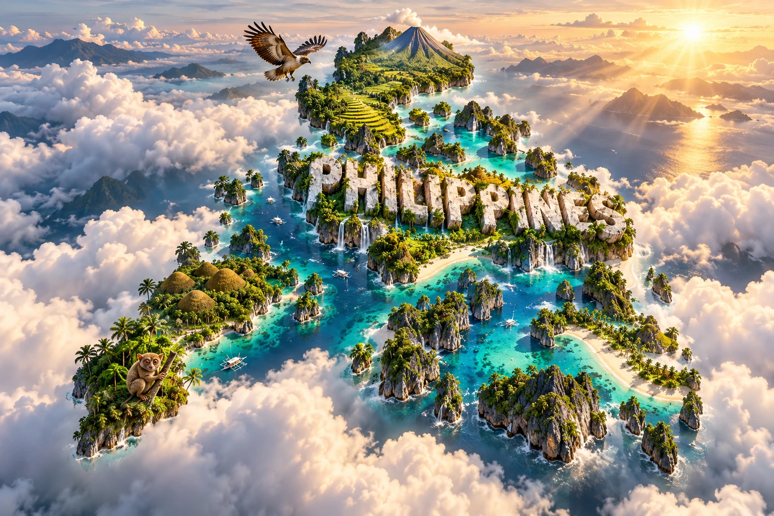
The Philippines artwork combines emerald rice terraces, steep limestone islands, turquoise lagoons, Mayon Volcano, beaches and coconut palms. Philippine eagles symbolize threatened forest biodiversity, while tarsiers represent specialized island wildlife. The embedded “PHILIPPINES” lettering is a graphic label rather than a landform.
The elements refer to real features but are geographically compressed. The UNESCO-listed terrace clusters lie in Ifugao in northern Luzon; Mayon is in southeastern Luzon; famous limestone seascapes occur particularly around Palawan; and Philippine tarsiers and eagles have restricted ranges. Coconut palms occur widely in suitable lowlands but do not represent every Philippine habitat.
The image is a conceptual artistic composition. The landmarks, wildlife and landscapes are combined for educational visualization and are not shown at their true geographic positions or scale. It is an illustrative floating micro-world, not a satellite map, navigational chart or scientifically exact habitat map.
12. Interesting Facts About the Philippines
- The modern official count recognizes 7,641 Philippine islands; older materials commonly state 7,107.
- The 2024 census recorded 112,729,484 people as of 1 July 2024.
- Luzon, the Visayas and Mindanao are island groups, not the names of three equal-sized islands.
- Oceanic crust descends along trenches on both sides of the archipelago, helping produce earthquakes and volcanoes.
- The Philippine Fault Zone runs through much of the country and accommodates part of the region's oblique plate motion.
- Mount Apo is the country's highest point at approximately 2,954 metres.
- Laguna de Bay is a shallow freshwater lake despite the word “Bay” in its name.
- Around 20 tropical cyclones enter the Philippine Area of Responsibility in an average year, while about eight or nine cross the country.
- The Philippine eagle survives only on parts of four major islands and is critically endangered.
- The tamaraw is native only to Mindoro.
- Tarsiers are primates, but they are not monkeys.
- The country has six UNESCO World Heritage properties, evenly divided between cultural and natural sites.
- The Ifugao rice terraces are functioning cultural landscapes maintained through farming and water management.
- The Philippines lies within the Coral Triangle, one of the world's richest regions for reef biodiversity.
- The 1991 Pinatubo eruption sent sulfur-rich material into the stratosphere and temporarily cooled global average surface temperatures.
13. Short Quiz
-
Why does the Philippines have many volcanoes? A. Oceanic plates subduct along trenches around the archipelago B. Coral reefs turn directly into magma C. Monsoon winds build mountains D. Every island is an inactive geyser
-
What does PAGASA's average of about 20 refer to? A. Tropical cyclones entering the Philippine Area of Responsibility B. Typhoons striking Manila directly C. Eruptions at Mayon each year D. Months in the wet season
-
Which animal is found naturally only on Mindoro? A. Dugong B. Tamaraw C. Philippine eagle D. Whale shark
-
What are the three broad island groups? A. Manila, Cebu and Davao B. Palawan, Bohol and Mindoro C. Luzon, Visayas and Mindanao D. Sulu, Celebes and Philippine
-
Why is the 3D image not a literal map? A. It combines distant landscapes, wildlife and landmarks at symbolic scales B. The Philippines has no mountains C. All islands are joined together D. Rice terraces grow beneath the sea
Answer key: 1-A, 2-A, 3-B, 4-C, 5-A
14. Related Learning
- Indonesia Explained: Shared island-arc volcanism and Coral Triangle ecosystems
- Malaysia Explained: Borneo, maritime trade and tropical forests
- Palau Explained: Western Pacific reefs and island geology
- Japan Explained: Comparing Pacific earthquakes, volcanoes and typhoons
- Why the Philippines Has So Many Volcanoes and Earthquakes
- How Monsoons and Typhoons Shape the Philippines
- How Limestone Created Palawan's Cliffs, Caves and Lagoons
- Why the Philippines Has So Many Endemic Species
- How Ifugao Rice Terraces Manage Mountain Water
- Why Mangroves and Coral Reefs Matter to Philippine Coasts
15. Sources
- Philippine Statistics Authority, official 2024 census population
- Official Gazette, Constitution of the Philippines: language provisions
- NAMRIA, mapping the number of Philippine islands
- PAGASA, tropical cyclone information
- PAGASA, climate change in the Philippines
- PHIVOLCS, introduction to Philippine volcanoes and tectonic setting
- PHIVOLCS, Philippine trenches map service
- UNESCO, Philippines World Heritage profile
- UNESCO, Rice Terraces of the Philippine Cordilleras
- UNESCO, Tubbataha Reefs Natural Park
- UNESCO, Puerto-Princesa Subterranean River National Park
- IUCN Red List, Philippine eagle
- Convention on Biological Diversity, Philippines country profile
- World Bank, Philippines Growth and Jobs Report 2025