

Oman occupies the southeastern corner of the Arabian Peninsula, where rugged mountains, gravel plains, great sand deserts and more than 3,000 kilometres of coastline meet. Its landscapes reveal an unusual geological story: rocks that once formed part of an ancient ocean floor were pushed onto the edge of Arabia and are now exposed in the Hajar Mountains.
The country is more varied than an endless desert. Floods rush through dry wadis, cold-water upwelling supports rich seas, and the summer monsoon covers parts of southern Dhofar in mist. Its coasts have linked Oman to East Africa and South Asia for centuries.
1. Where Is Oman?
Oman lies in Western Asia on the southeastern Arabian Peninsula. It borders the United Arab Emirates, Saudi Arabia and Yemen. The Gulf of Oman borders the northeast coast, while the Arabian Sea extends along the east and south.
Muscat, the capital, lies between the Gulf of Oman and the Hajar Mountains. Other important urban and economic centers include Salalah in Dhofar, Sohar on the Al Batinah coast, Nizwa in the interior and the developing port city of Duqm.
Oman's territory is geographically unusual. The Musandam Peninsula is separated from the main part of Oman by United Arab Emirates territory. Its mountains overlook the Strait of Hormuz, the narrow sea passage connecting the Persian Gulf with the Gulf of Oman. Oman also contains Madha, an enclave surrounded by the UAE; inside Madha is Nahwa, a smaller UAE counter-enclave.
Oman is therefore a coastal country with a mainland, an exclave and an enclave—not an island nation.
2. Quick Country Facts
- Official name: Sultanate of Oman
- Capital: Muscat
- Region: Western Asia; southeastern Arabian Peninsula
- Area: Approximately 309,500 square kilometres
- Population: About 5.36 million in 2025, including approximately 3.04 million Omanis and 2.32 million expatriate residents
- Currency: Omani rial
- Official language: Arabic; English and several Omani, South Asian and other languages are also used
- Time zone: Gulf Standard Time, UTC+4, with no seasonal clock change
- Highest point: Jabal Shams, about 3,000 metres above sea level
- Major water features: No permanent rivers; wadis, groundwater, springs, aflaj irrigation channels and reservoirs are important
- Coasts: Gulf of Oman and Arabian Sea
- World Heritage: Five UNESCO World Heritage properties, all currently listed as cultural sites
- Political system: Sultanate
Population and area figures vary by source and date. The official population total above includes Oman's large expatriate community.
3. Geography and Landscape
The Hajar Mountains curve through northern Oman from Musandam toward the eastern coast. Their sharp ridges rise abruptly behind the narrow Al Batinah coastal plain. Jabal Shams is the country's highest summit, while the Jabal Akhdar highlands contain cooler terraces where pomegranates, roses and other crops can grow. Deep valleys—including Wadi Ghul—cut into limestone plateaus and mountain rock.
Wadis are channels that may remain dry for long periods but carry powerful flows after heavy rain. Some mountain wadis contain springs or persistent pools, including well-known turquoise sections, but this water is localized. It would be misleading to imagine every Omani valley as a permanent river or swimming pool.
Much of central Oman consists of stony plateau and gravel desert rather than tall dunes. The Sharqiyah Sands contain long wind-built ridges, while the Rub al Khali, or Empty Quarter, reaches into southwestern Oman.
Dhofar in the south is separated from northern Oman by a large arid interior. Around Salalah, a coastal plain lies beneath an escarpment. During the summer khareef, moist air produces low cloud and drizzle on seaward slopes, creating seasonally green grassland and woodland. Just beyond the mountains, the landscape becomes dry again.
Musandam's limestone mountains descend into sea inlets called khors. They resemble fjords, but glaciers did not carve them; tectonic movement, river erosion and changing relative sea level helped drown the valleys.
4. Why Does Oman Look Like This?
Northern Oman's most extraordinary geological feature is the Semail ophiolite. An ophiolite is a section of oceanic crust and upper mantle exposed on land. These rocks formed in the ancient Tethys Ocean during the Cretaceous Period. As tectonic plates converged, a huge slab of oceanic material was thrust, or obducted, over the edge of the Arabian continental plate instead of being entirely dragged beneath it.
Later uplift and erosion exposed mantle peridotite, former ocean crust and marine sedimentary rocks across the Hajar region. Geologists can therefore study ancient ocean floor without drilling through a modern ocean.
Water then shaped the uplifted terrain. Rain is infrequent, but intense storms can send flash floods through narrow wadis. These flows move boulders and sediment, deepen channels and build alluvial fans where valleys open onto plains. Groundwater dissolves limestone and emerges at springs, while people have redirected some of it through aflaj for centuries.
Wind sorts and transports sediment, building the long dunes of the Sharqiyah Sands and repeatedly reworking sand within the Rub al Khali basin.
In Dhofar, relief interacts with the Indian Ocean monsoon. Moist summer air cools as it rises against the escarpment, forming fog and drizzle. The mountains capture this moisture on their seaward side and create a rain shadow inland. Oman's variety therefore comes from plate tectonics, erosion, wind, water and sharply regional climate—not from desert processes alone.
5. Climate
Most of Oman has a hot, arid climate. Lowland summers are intensely hot, and humidity can be high along the northern coast. Winters are generally milder. Interior locations have a larger difference between daytime and nighttime temperatures, while high mountains can be cool and occasionally experience freezing conditions.
Rainfall is low and irregular across much of the country. Northern mountains receive more rain than surrounding plains when moist air rises over them, but downpours may be brief. Hard ground and steep valleys allow water to gather quickly, making flash floods dangerous even when rain falls far upstream.
Tropical cyclones from the Arabian Sea sometimes affect Oman. They can bring exceptional rain, damaging floods, waves and storm surge to areas that receive little precipitation in ordinary years. A dry climate therefore does not mean freedom from severe water hazards.
Dhofar follows a different seasonal rhythm. From roughly June to September, the khareef brings cloud, fog and light rain to the Salalah plain and nearby seaward slopes. Ocean upwelling helps cool coastal waters and air. Vegetation turns green, but the effect is geographically limited: northern Oman and the desert behind the Dhofar escarpment do not share the same misty summer climate.
Climate change adds pressure through extreme heat, intense rainfall, coastal risks and water scarcity. Excessive pumping can also lower water tables or draw saltwater into coastal aquifers.
6. Wildlife and Ecosystems
Oman's habitats include mountain cliffs, deserts, seasonal grassland, frankincense country, mangroves, coral reefs, islands and Arabian Sea waters. Species are not evenly distributed across the country.
The Arabian oryx is a desert antelope adapted to heat and scarce water. It became extinct in the wild in the 1970s before captive breeding and reintroduction programs returned it to protected areas. Oman's herds remain localized and managed, so the oryx in the artwork represents national conservation heritage rather than an animal encountered everywhere.
The endangered Arabian tahr lives in rugged parts of the Hajar Mountains of Oman and the UAE. It is especially associated with cliffs and steep slopes, not open dunes. The critically endangered Arabian leopard has a tiny, highly threatened range; in Oman it is associated mainly with remote mountains in Dhofar, including the Jabal Samhan area. Nubian ibex, Arabian gazelles, foxes, wolves and caracals also occupy suitable but differing habitats.
Several sea turtle species use Oman's coasts. Green turtles nest in large numbers around the Ras al Hadd–Ras al Jinz area, while Masirah Island is especially important for loggerhead turtles. Hawksbill and olive ridley turtles also occur. Nesting beaches are sensitive to lights, vehicles, disturbance, fishing bycatch and coastal development.
Oman's seas support dolphins, whales, reef fish and seabirds. Its small, isolated Arabian Sea humpback whale population does not undertake the long polar migrations typical of most humpbacks. Coral, mangroves and seagrass face warming, pollution and development pressures.
In Dhofar, Boswellia sacra trees produce frankincense resin in dry foothills and wadis. Frankincense woodland is not a lush rainforest, and date palms shown in oasis scenes are cultivated crops dependent on water management. These distinctions help separate natural habitat from agricultural landscape.
7. Famous Landmarks and Natural Features
Oman's five current UNESCO World Heritage properties illuminate different parts of its past:
- Bahla Fort is a vast earthen stronghold within an oasis settlement. Its walls, mosque, traditional lanes and irrigation landscape reflect the history of interior Oman and the importance of Ibadi communities.
- The Aflaj Irrigation Systems of Oman represent ancient community-managed channels that distribute groundwater or spring water to homes and fields. UNESCO lists five representative systems, although thousands of aflaj exist across the country.
- Bat, Al-Khutm and Al-Ayn preserve settlements, towers and distinctive beehive-shaped tombs from the third millennium BCE, offering evidence of early communities and long-distance exchange.
- The Land of Frankincense links Wadi Dawkah's frankincense trees with the caravan oasis of Shisr and the ports of Khor Rori and Al-Baleed, showing how resin moved from Dhofar into international trade.
- The Ancient City of Qalhat was a major port between the 11th and 16th centuries, connecting Arabia with India, East Africa, China and Southeast Asia through the trading world of Hormuz.
Other landmarks include Nizwa Fort, Al Jalali and Al Mirani forts above Muscat's harbor, and the modern Sultan Qaboos Grand Mosque. They belong to different periods and styles.
Natural landmarks include the Hajar highlands, Jabal Shams, Wadi Ghul, Sharqiyah Sands, Dhofar's escarpment, Ras al Jinz and Musandam's drowned valleys. The former Arabian Oryx Sanctuary is no longer a World Heritage property: UNESCO removed it in 2007 after its protected area was greatly reduced.
8. People, Languages and Culture
Omani society includes diverse regional, tribal, linguistic and ancestral communities. Arabic is official, while Baluchi, Swahili, Kumzari, Mehri and Shehri/Jibbali connect to particular communities or regions. English is widely used, and expatriate residents bring many South Asian and other languages.
Most Omani citizens are Muslim. Ibadism has played an especially important role in Oman's religious and political history, while Sunni and Shia communities are also part of the country. Religious identity, like language and ancestry, should not be assumed from clothing or location.
Indian Ocean exchange connected Omani ports with South Asia, Zanzibar and the Swahili coast. An Omani-ruled empire extended influence into East Africa. Its history included cultural exchange and commerce but also enslavement and coercion; it should not be romanticized as trade alone.
Clothing and performance vary. Men's dishdashas and embroidered caps called kumma are recognizable, while turbans and women's garments differ by place and occasion. Razha poetry and sword performance, Dhofari bar'a, maritime work songs and liwa traditions with African connections represent only part of a wider musical landscape.
Dhows symbolize Indian Ocean sailing, but the term covers several vessel types used across many countries. Neither dhows nor forts represent every Omani person's daily life.
9. Food
Omani food reflects desert pastoral life, oasis agriculture, coastal fishing and centuries of exchange around the Indian Ocean. Rice, meat, fish, dates and aromatic spices appear in many dishes, but recipes vary among households and regions.
Shuwa is spiced meat slowly cooked in an underground oven for major celebrations. Majboos combines spiced rice with meat or fish; harees cooks wheat with meat; and mashuai pairs roasted kingfish with rice and citrus sauce.
Dates are offered with lightly spiced Omani coffee, often called qahwa, as a sign of hospitality. Omani halwa is a dense sweet flavored with ingredients such as rosewater, saffron, cardamom and nuts. Coastal diets make extensive use of fish, while coconuts and bananas are particularly associated with Dhofar. These are well-known traditions, not a complete menu eaten uniformly by everyone.
10. Economy and Major Industries
Oil and natural gas transformed Oman's public finances and infrastructure and remain important exports and sources of government revenue. Production is smaller than in some neighboring Gulf states, and fluctuating energy prices create economic and budget risks.
Oman Vision 2040 emphasizes diversification and a larger private-sector role. Manufacturing and petrochemicals cluster around Sohar and Duqm. Mining includes gypsum, limestone, copper and chromite. Ports at Sohar, Salalah and Duqm strengthen logistics.
Fishing is both a livelihood and a growth sector. Tourism, digital services, renewable energy and green hydrogen are also part of diversification plans, with water use and ecological effects requiring care.
Agriculture occupies a small share of the land because water is scarce. Dates, limes, vegetables and fodder grow in irrigated areas; Dhofar also produces coconuts, bananas and livestock. Aflaj, wells, dams and desalination all contribute to water supply, but groundwater extraction must remain within recharge limits.
Expatriate workers form a substantial part of the population and labor force. Policies promoting Omani employment operate alongside this dependence on international labor.
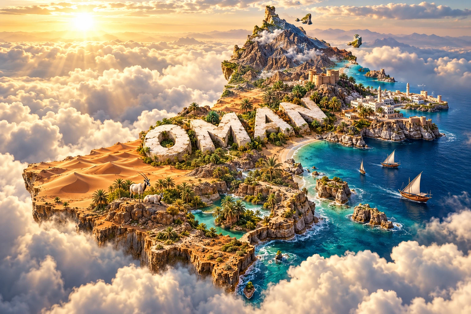
11. What the 3D Visual Represents
The Oman artwork combines the Hajar Mountains, golden desert dunes, turquoise wadi pools and a dramatic coast to communicate the country's major physical regions. White buildings and forts evoke Muscat and Oman's architectural heritage. Date palms represent irrigated oasis agriculture, while dhow boats recall fishing and long Indian Ocean connections.
The Arabian oryx represents desert adaptation and conservation. It should not be read as evidence that oryx roam every dune, mountain or city; present populations are localized. Likewise, permanent blue water occurs only in particular wadis and springs, not throughout the dry valley network. The large embedded “OMAN” lettering is a graphic identification device rather than a feature of the landscape.
The image is a conceptual artistic composition. The landmarks, wildlife and landscapes are combined for educational visualization and are not shown at their true geographic positions or scale. It is an illustrative floating micro-world, not a satellite map, route map or reconstruction of one real viewpoint.
12. Interesting Facts About Oman
- Northern Oman exposes the Semail ophiolite, one of the world's most extensive sections of ancient oceanic crust and upper mantle visible on land.
- The Musandam exclave overlooks the Strait of Hormuz but is separated from mainland Oman by the United Arab Emirates.
- Madha is an Omani enclave inside the UAE, and Nahwa is a UAE counter-enclave inside Madha.
- Oman has no permanent river system; wadis flow episodically, and groundwater is vital.
- Aflaj distribute water by gravity and traditional sharing rules rather than simply functioning as decorative canals.
- Dhofar's khareef is created by the summer monsoon, ocean upwelling and rising moist air along the escarpment.
- The green khareef zone covers only part of southern Oman; arid land lies close behind the mountains.
- Arabian oryx were restored to the wild through captive breeding and reintroduction after disappearing from the wild in the 1970s.
- The Arabian tahr is restricted to the rugged mountains of Oman and the neighboring UAE.
- Masirah Island holds globally important loggerhead turtle nesting habitat.
- Frankincense is aromatic resin tapped from Boswellia trees, not a fruit or manufactured perfume.
- Ancient Qalhat connected Arabia to a maritime trade network reaching East Africa and Asia.
- The beehive tombs of Al-Ayn belong to the third millennium BCE and are much older than Oman's better-known forts.
- Musandam's khors may look like Norwegian fjords, but they were not carved by glaciers.
- The Arabian Sea humpback whale population is unusual because it remains in the northern Indian Ocean instead of migrating to polar feeding grounds.
13. Short Quiz
-
What geological feature exposes ancient ocean crust in northern Oman? A. The Semail ophiolite B. A young volcanic island chain C. A continental ice sheet D. The Nile Delta
-
Why does part of Dhofar turn green in summer? A. Snowmelt from the Hajar Mountains B. The khareef brings moist monsoon air, fog and drizzle C. A permanent tropical rainforest covers Oman D. Water flows from the Euphrates
-
What is an aflaj system designed to do? A. Build coastal dunes B. Record earthquake magnitude C. Distribute water to settlements and fields D. Guide whales through the Strait of Hormuz
-
Which statement about the Arabian oryx is accurate? A. It is naturally widespread in every part of Oman B. It lives only in mangrove forests C. Reintroduction restored it after extinction in the wild D. It is a domesticated goat
-
Why are Musandam's khors not true glacial fjords? A. They contain freshwater only B. They formed in drowned valleys without glacial carving C. They are artificial canals D. They are located below desert dunes
Answer key: 1-A, 2-B, 3-C, 4-C, 5-B
14. Related Learning
- United Arab Emirates Explained: Oman's neighbor and the geography surrounding Musandam and Madha
- Saudi Arabia Explained: The Arabian Peninsula, Rub al Khali and shared desert systems
- Yemen Explained: Monsoon influence, highlands and Oman's southwestern border
- How Ancient Ocean Crust Became the Hajar Mountains
- Why Dhofar Turns Green During the Khareef
- How Aflaj Irrigation Shares Water in Dry Landscapes
- Why Flash Floods Occur in Desert Wadis
- How Sea Turtles Navigate Back to Nesting Beaches
- How Frankincense Connected Arabia, Africa and Asia
- Why the Strait of Hormuz Matters to World Geography
15. Sources
- National Centre for Statistics and Information, Statistical Year Book 2026
- UN Data, Oman country profile
- U.S. Geological Survey, geology of the Semail ophiolite
- UNESCO, Oman World Heritage properties
- UNESCO, Aflaj Irrigation Systems of Oman
- UNESCO, Land of Frankincense
- UNESCO, Ancient City of Qalhat
- UNESCO, Bahla Fort
- UNESCO, Arabian Oryx Sanctuary listing history
- UNESCO Man and the Biosphere Programme, Sirrin Biosphere Reserve
- UNESCO, Arabian Leopard Reserve tentative listing
- Environment Authority of Oman, role and conservation overview
- World Bank, Gulf Economic Update—Oman
- Oman Vision 2040, national programs