

Jordan is a predominantly dry country whose landscape descends from eastern desert across a populated highland spine into one of Earth's deepest continental depressions. The Dead Sea Transform, scarce rainfall and thousands of years of human water management explain much of what visitors see—from the Jordan Valley and sandstone towers of Wadi Rum to rock-cut Petra and basalt towns in the north.
Jordan is often pictured as uninterrupted sand, but that image misses Mediterranean woodland, cultivated uplands, steppe, wetlands, coral reefs and dense cities. Its location between Arabia, the Levant and the Jordan Rift has also made it a corridor for trade, migration, empires and ideas.
1. Where Is Jordan?
Jordan lies in Western Asia, in the southern Levant. It borders Syria to the north, Iraq to the east, Saudi Arabia to the east and south, and Israel and the occupied West Bank to the west. The Jordan River, Dead Sea and Wadi Araba form much of its western edge.
The country is almost landlocked but has a short coastline at Aqaba, on the Gulf of Aqaba at the northern end of the Red Sea. That narrow opening gives Jordan its only seaport and access to coral-reef ecosystems.
Amman, built across hills in northwestern Jordan, is the capital and largest city. Zarqa and Irbid are major population and industrial centers. Aqaba is the principal port, while Salt, Madaba, Karak and Ma'an are important regional and historic cities.
The West Bank is occupied Palestinian territory, not part of Jordan. Jordan administered the West Bank from 1948 until Israel occupied it in 1967 and formally ended its administrative and legal ties in 1988, except for its recognized custodial role concerning Muslim and Christian holy sites in Jerusalem.
2. Quick Country Facts
- Official name: Hashemite Kingdom of Jordan
- Capital: Amman
- Region: Western Asia; southern Levant
- Area: approximately 89,342 square kilometers
- Population: approximately 11.52 million in 2025, World Bank estimate
- Currency: Jordanian dinar (JOD)
- Official language: Arabic; English is widely used in education and business
- Time zone: UTC+3 year-round
- Highest point: Jabal Umm ad Dami, about 1,854 meters
- Lowest area: Dead Sea shore, whose elevation changes as the lake contracts
- Major river: Jordan River, a shared transboundary watercourse
- Political system: constitutional hereditary monarchy with a parliamentary system
- Administrative divisions: 12 governorates
Population estimates include citizens and non-citizen residents. Jordan hosts substantial refugee populations, and totals can change with migration as well as births and deaths.
3. Geography and Landscape
Most of Jordan belongs to an arid plateau extending into the Syrian and Arabian deserts. The east contains broad expanses of stone and gravel rather than continuous sand dunes. Basalt lava fields cover parts of the northeast, where dark volcanic rock forms the Harrah landscape.
A north–south chain of highlands overlooks the rift valley in western Jordan. Around Ajloun, higher rainfall supports woodland and farming. The central plateau contains Amman, Madaba and Salt; farther south, the heights of Karak, Tafila and Sharah are divided by deep wadis. Olives, fruit, cereals and grazing occur where soils and water permit.
The land drops sharply westward into the Jordan Rift Valley. The Jordan Valley in the north is warmer and irrigated. The Dead Sea occupies a closed basin far below sea level. South of it, Wadi Araba continues toward the Gulf of Aqaba.
The Dead Sea has no natural ocean outlet. Water entering from the Jordan River and smaller wadis leaves mainly through evaporation, concentrating salts. River diversion, groundwater use and mineral extraction have accelerated its decline, causing shoreline retreat and sinkholes.
Southern Jordan contains sandstone and granite mountains, dry valleys and sandy plains. Wadi Rum is famous for towering cliffs, arches, gorges and isolated massifs. Jordan's small Aqaba coast contains beaches, seagrass and fringing coral reefs beside a busy port city.
4. Why Does Jordan Look Like This?
Western Jordan follows the Dead Sea Transform, a major left-lateral fault boundary between the Arabian Plate and the Sinai–African plate region. The blocks mainly slide past each other, but bends and gaps in the fault have allowed deep basins to subside. The Dead Sea basin contains several kilometers of sediment and remains tectonically active.
Movement along this boundary helped create the steep escarpments bordering the Jordan Valley, Dead Sea and Wadi Araba. It also produces earthquake risk. Uplift raised the adjacent plateaus, giving short streams enough energy to cut deep canyons as they descend toward the rift.
Much of the plateau consists of limestone and related sedimentary rocks deposited in ancient seas. Water dissolves limestone along fractures, creating springs, caves and underground flow. In the south, older sandstone was fractured, uplifted and then sculpted by wind, water, salt weathering and temperature changes into Wadi Rum's cliffs and natural arches.
Wadi Rum is therefore not simply a field of wind-blown dunes. Its large landforms began with layers of rock and tectonic fractures; rare but powerful runoff widened joints and carved gorges, while wind and weathering refined exposed surfaces.
The northeastern basalt desert records volcanic eruptions that spread lava across the region during several periods. Weathering later broke the flows into dark, angular stones, producing a landscape very different from the pale limestone plateau and red southern sandstone.
5. Climate
Jordan has mainly arid and semi-arid climates, but elevation and exposure create sharp differences. Summers are hot and dry almost everywhere. Winters range from mild in the Jordan Valley and Aqaba to cold on the highlands, where frost and occasional snow can occur.
Most rain falls from roughly November to April as Mediterranean weather systems move east. Northwestern highlands receive the greatest totals. Rainfall drops rapidly toward the east and south, where some desert areas receive very little in an average year.
Altitude explains why Amman can be cool while the nearby Dead Sea shore is warm. Descending into the rift raises temperatures, and the enclosed basin has very hot summers. Aqaba is also hot and dry, moderated somewhat by the gulf.
Dry riverbeds called wadis can become dangerous torrents when intense rain falls upstream. Flash floods have affected Petra, Wadi Musa and other canyon settings even when skies nearby initially appeared clear.
Jordan is among the world's most water-scarce countries. Population growth, refugee inflows, groundwater depletion, inefficient losses and climate change add pressure to limited supplies. The national strategy combines conservation, network improvements, wastewater reuse and desalination plans, but no single project removes the need for careful management.
6. Wildlife and Ecosystems
Jordan sits where Mediterranean, Irano-Turanian, Saharo-Arabian and Sudanian ecological influences meet. This creates more habitat variety than the word “desert” suggests.
Northern and western uplands retain patches of oak, pine, juniper and shrubland. The Dana Biosphere Reserve spans a dramatic elevation range from plateau to Wadi Araba and contains several vegetation zones. Mujib Biosphere Reserve protects steep canyons draining toward the Dead Sea.
Desert and steppe wildlife includes dorcas gazelles, goitered gazelles, striped hyenas, wolves, foxes, caracals and many reptiles, but populations are localized and often sparse. Nubian ibex use rocky cliffs and canyon terrain rather than open desert everywhere.
The Arabian oryx disappeared from the wild in Jordan but has been reintroduced in the Shaumari reserve through conservation breeding. A reintroduced population does not mean the species is widespread or free from management.
Jordan lies on an important bird-migration route. Raptors, storks, waterbirds and passerines move through the rift and wetlands seasonally. Azraq Wetland Reserve is a vital oasis, although groundwater pumping severely reduced the original wetland and restoration now depends partly on managed water.
At Aqaba, coral reefs, seagrass beds and deeper low-light reefs support exceptional marine diversity. UNESCO inscribed Aqaba Marine Reserve in 2026, recognizing the world's northernmost tropical coral-reef system and its unusually heat-resilient corals. Port activity, coastal development, pollution and warming still require close monitoring.
7. Famous Landmarks and Natural Features
Petra was the rock-cut capital of the Nabataeans and a major caravan center linking Arabia, Egypt and the Mediterranean world. Its famous Treasury is only one monument within a large landscape of tombs, temples, water channels, dams, paths and settlements. Nabataean engineers managed scarce and dangerous water with remarkable skill.
Wadi Rum Protected Area is a UNESCO mixed cultural-and-natural property. Its cliffs, arches and gorges preserve tens of thousands of petroglyphs and inscriptions documenting roughly 12,000 years of human presence and changing languages.
The Dead Sea is significant for geology, ecology, industry and the religious histories of the region. Its retreat is visible in abandoned shore facilities and newly exposed ground. It is a shared lake bordered by Jordan, Israel and the occupied West Bank—not a feature belonging to one country alone.
Jerash preserves an extensive Greco-Roman urban landscape, later Byzantine churches and evidence from other periods. Amman Citadel similarly contains remains spanning the Bronze Age, Roman, Byzantine and Umayyad eras.
Jordan's “desert castles” are a varied group rather than identical fortresses. Quseir Amra contains important early Islamic frescoes; Qasr al-Kharana may have served administrative and meeting functions; and Azraq Castle was built and reused across multiple periods.
Umm Al-Jimal, inscribed by UNESCO in 2024, preserves basalt buildings from a rural settlement with Roman, Byzantine and early Islamic layers. Ancient reservoirs and channels show how communities captured water in a dry environment.
Jordan had eight UNESCO World Heritage properties as of September 2026: six cultural sites, mixed Wadi Rum and natural Aqaba Marine Reserve.
8. People, Languages and Culture
Jordanian society includes families with roots in towns, farming villages, Bedouin tribes, Circassian and Chechen communities, and communities of Palestinian, Syrian, Iraqi and other origin. Many people hold layered identities. “Bedouin” describes diverse tribal histories and ways of life; it should not be used as a synonym for every Jordanian or every desert resident.
Arabic is the official language. Everyday Jordanian Arabic has regional and social varieties, while Modern Standard Arabic is used in formal writing and broadcasting. English is widely taught, and Circassian, Chechen, Armenian and other languages are maintained in some communities.
Hospitality is highly valued, and coffee can carry social and ceremonial meaning. Yet a staged desert camp is only one presentation of culture. Most Jordanians live in urban areas, and contemporary life includes universities, technology, film, literature, design and popular music alongside rural and pastoral traditions.
The territory contains evidence of prehistoric settlement and belonged at different times to Ammonite, Moabite, Edomite, Nabataean, Roman, Byzantine and successive Islamic polities. It later formed part of the Ottoman Empire. The Emirate of Transjordan was established under British mandate arrangements, and the kingdom became independent in 1946.
Palestinian displacement in 1948 and 1967 profoundly shaped Jordan's population. More recent conflicts brought Iraqi and Syrian refugees. Legal status, citizenship and access to services differ among refugee groups, so they should not be described as one uniform population.
Traditional arts include embroidery, weaving, mosaics, metalwork, storytelling and music. The cultural space of the Bedu in Petra and Wadi Rum is recognized by UNESCO as intangible heritage, emphasizing knowledge, oral expression and relationships with the desert—not merely tents and camels.
9. Food
Jordanian food belongs to wider Levantine and Arabian culinary traditions while also having regional specialties. Mansaf, often regarded as the national dish, combines rice, lamb and jameed, a dried fermented yogurt. It is commonly served for important gatherings, but it is not an everyday meal for everyone.
Maqluba layers rice with vegetables and meat before the pot is inverted for serving. Mezze may include hummus, mutabbal, tabbouleh, pickles and salads—foods shared across several countries and communities.
Other dishes include galayet bandora made with tomatoes, mujaddara of lentils and grain, stuffed vegetables, grilled meats and Bedouin-associated zarb, cooked in an underground oven. Kanafeh and other syrup-soaked pastries are popular sweets. Olive oil, bread, yogurt, herbs and seasonal vegetables remain important foundations.
10. Economy and Major Industries
Services provide most economic activity, including government, finance, trade, transport, education, health, telecommunications, information technology and tourism. Amman is the main business center, while Aqaba connects Jordan to maritime trade.
Manufacturing includes pharmaceuticals, garments, food products, chemicals and construction materials. Jordan is an important producer of phosphate rock and potash, the latter extracted from Dead Sea brines. Mineral production earns exports but must be balanced against water, energy and environmental costs.
Agriculture contributes a relatively small share of output because water and arable land are limited. Irrigated Jordan Valley farms produce vegetables and fruit, while olives and cereals grow in higher-rainfall areas. Farming nevertheless has social and food-security importance.
Tourism links livelihoods to Petra, Wadi Rum, archaeological sites, religious heritage, medical services and nature reserves. It is sensitive to regional conflict even when events occur outside Jordan.
The World Bank estimated Jordan's population at 11.52 million and GDP at about US$61.6 billion in 2025. Unemployment, public debt, energy imports, refugee-service costs and extreme water scarcity remain structural challenges. Remittances and international assistance also affect household and national finances.
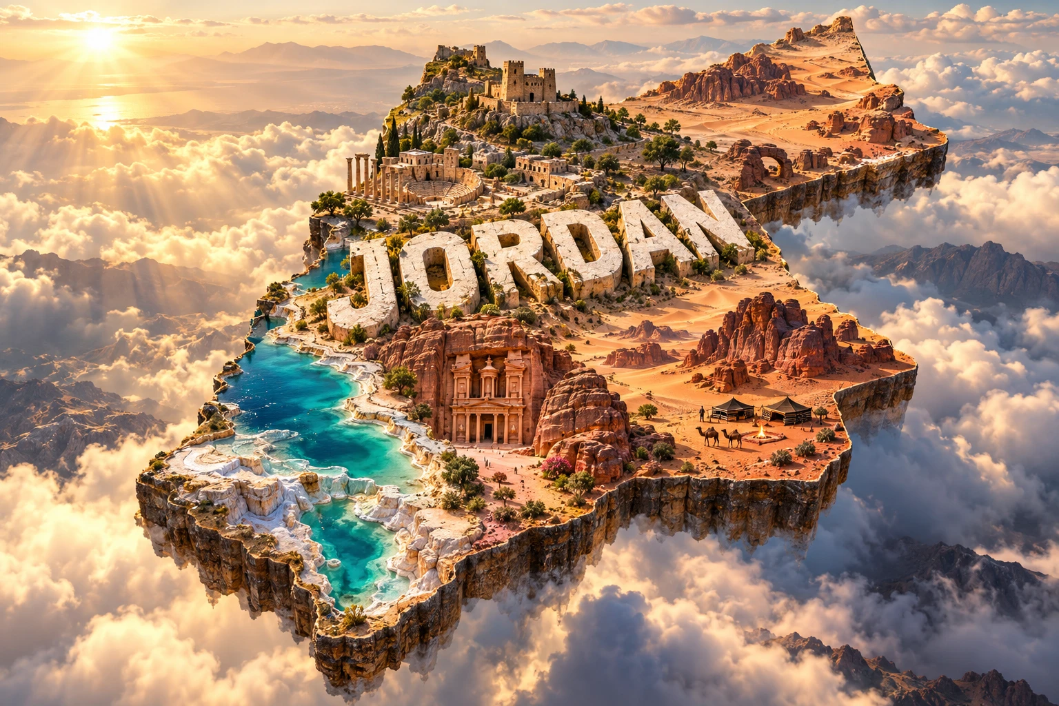
11. What the 3D Visual Represents
The Jordan artwork combines Petra-inspired rose-colored rock architecture, Wadi Rum formations, a Dead Sea shore, ancient castles, desert camps and camels. Petra evokes Nabataean engineering and long-distance trade; Wadi Rum represents sandstone landforms and deep records of human occupation; and the Dead Sea points to the transform-fault basin and extreme evaporation.
The castles symbolize several periods, but Jordan's castles differ in date and function and should not be merged into one generic type. Desert camps and camels reference Bedouin heritage and pastoral mobility without representing how all Jordanians live. Camels are domesticated animals, not the country's principal wild fauna.
The scene omits Amman's urban landscape, northern woodland, farms, basalt desert, Azraq wetlands and Aqaba's coral reefs.
The image is a conceptual artistic composition. The rock-cut buildings, sandstone formations, Dead Sea shore, castles, camps and camels are combined for educational visualization and are not shown at their true geographic positions or scale. It is a floating micro-world illustration, not a satellite map.
12. Interesting Facts About Jordan
- Jordan has only a short coastline, located at Aqaba on the Red Sea system.
- The eastern desert includes extensive stone and basalt surfaces, not just sand dunes.
- Jabal Umm ad Dami is Jordan's highest point at about 1,854 meters.
- The Dead Sea Transform is a sliding plate boundary that helped form the rift valley.
- The Dead Sea has no ocean outlet and becomes saline as water evaporates.
- Wadi Rum preserves petroglyphs and inscriptions spanning thousands of years.
- Petra's water channels and dams were as essential as its carved façades.
- Umm Al-Jimal's basalt buildings record Roman, Byzantine and early Islamic history.
- Azraq's oasis survives today partly through managed water restoration.
- Arabian oryx have been reintroduced after disappearing from Jordan's wild landscapes.
- Aqaba contains the world's northernmost tropical coral-reef system.
- UNESCO added Aqaba Marine Reserve in 2026, bringing Jordan's World Heritage total to eight.
- Arabic is official, while English is widely used in business and education.
- Mansaf uses jameed, a dried fermented yogurt product.
- Jordan is one of the world's most water-scarce countries.
13. Short Quiz
-
Which tectonic feature helped create Jordan's western rift landscape? A. Dead Sea Transform B. Mid-Atlantic Ridge C. Hawaiian hotspot D. Alpine glacier
-
What was Petra's central historic role? A. Nabataean capital and caravan center B. Modern seaport C. Volcanic observatory D. Crusader-only fortress
-
Why is the Dead Sea highly saline? A. Water leaves mainly through evaporation B. Atlantic tides enter daily C. Glaciers deposit salt D. Coral produces all its minerals
-
Which ecosystem was added to Jordan's World Heritage properties in 2026? A. Aqaba Marine Reserve B. Amazon rainforest C. Alpine tundra D. Nile Delta
-
What do camels in the visual represent? A. Selected pastoral and desert heritage B. Every Jordanian livelihood C. Jordan's main wild predator D. Marine biodiversity
Answer key: 1-A, 2-A, 3-A, 4-A, 5-A
14. Related Learning
Suggested internal-link opportunities:
- Israel Explained: Geography, Culture, Wildlife and Landmarks
- Saudi Arabia Explained: Deserts, Mountains and Culture
- Iraq Explained: Rivers, Civilizations and Landscapes
- Syria Explained: Geography, Rivers and Historic Cities
- How the Dead Sea Transform Shaped Jordan
- Why the Dead Sea Is Shrinking
- How Petra's Nabataeans Managed Water
- How Wadi Rum's Sandstone Arches Formed
- Why Jordan Is So Water-Scarce
- Why Aqaba's Coral Reefs Resist Unusual Heat
15. Sources
- Jordan Department of Statistics — Population , for official 2025 national estimates and methodology
- World Bank — Jordan Data , for dated population and economic indicators
- Jordan Ministry of Water and Irrigation — National Water Strategy 2023–2040 , for water scarcity and management priorities
- U.S. Geological Survey — Geology of the Dead Sea Rift Basins , for transform faulting, subsidence and basin depth
- UNESCO World Heritage Centre — Jordan , for the current eight-property list
- UNESCO — Petra , for Nabataean trade, archaeology and water-engineering context
- UNESCO — Wadi Rum Protected Area , for geology, inscriptions and long human occupation
- UNESCO — Umm Al-Jimal , for basalt architecture and ancient water capture
- UNESCO — Aqaba Marine Reserve , for its 2026 inscription, coral ecosystems and biodiversity
- UNESCO Intangible Cultural Heritage — Cultural Space of the Bedu in Petra and Wadi Rum , for Bedu knowledge and living heritage
- UNHCR — Jordan , for current refugee context and population diversity
- Encyclopaedia Britannica — Jordan , for stable geographic, historical and cultural background