

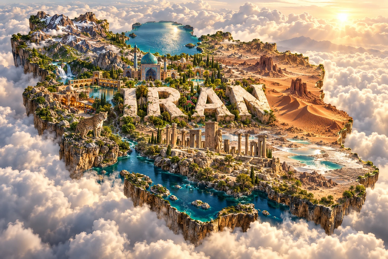
Iran is a large Western Asian country where young fold mountains surround a high, dry interior plateau. The Zagros and Alborz ranges capture rain and snow, while the enclosed Dasht-e Kavir and Dasht-e Lut contain salt flats, dunes and wind-carved ridges. Beyond the Alborz, the narrow Caspian coast supports humid forest unlike most of the country.
Water scarcity has shaped settlement, farming, architecture and garden design for millennia. Qanats carry groundwater through gently sloping tunnels, Persian gardens organize scarce water into shade and symmetry, and cities grew at mountain fronts where springs and underground water were accessible. Iran's geography is therefore not simply “desert”; it is an interaction among mountains, basins, coasts and human engineering.
1. Where Is Iran?
Iran lies in Western Asia, between the Caspian Sea to the north and the Persian Gulf and Gulf of Oman to the south. It borders Iraq and Turkey to the west; Armenia and Azerbaijan to the northwest; Turkmenistan to the northeast; and Afghanistan and Pakistan to the east.
The Strait of Hormuz, between Iran and Oman, links the Persian Gulf with the Gulf of Oman and Arabian Sea. It is one of the world's strategically important maritime passages because large volumes of oil and gas move through it.
Tehran, at the foot of the Alborz Mountains, is the capital and largest metropolitan area. Other major cities include Mashhad, Isfahan, Shiraz, Tabriz, Karaj, Qom and Ahvaz. Bandar Abbas is a major southern port, while Rasht serves the humid Caspian region.
Iran is sometimes described as part of the Middle East, but Western Asia is the clearer geographic term. Historically, “Persia” was widely used abroad; Iran has long been the country's own name, while Persian describes a major language and cultural tradition rather than every citizen.
2. Quick Country Facts
- Official name: Islamic Republic of Iran
- Capital: Tehran
- Region: Western Asia
- Area: approximately 1.65 million square kilometers
- Population: approximately 92.4 million in 2025, World Bank estimate
- Currency: Iranian rial (IRR); toman is widely used informally as ten rials
- Official language: Persian, also called Farsi
- Other major languages: Azerbaijani Turkic, Kurdish, Luri, Arabic, Balochi, Turkmen and others
- Time zone: Iran Standard Time, UTC+3:30
- Highest point: Mount Damavand, approximately 5,610 meters; published measurements vary
- Major river: Karun
- Largest inland lake: Lake Urmia, a highly variable saline lake
- Coasts: Caspian Sea, Persian Gulf and Gulf of Oman
Population and economic figures require dates. The rial is the legal currency even though everyday prices are often quoted in tomans.
3. Geography and Landscape
Mountain ranges dominate Iran's edges and divide it into distinct regions. The Zagros Mountains extend from the northwest toward the Strait of Hormuz. Long, parallel ridges and valleys support oak woodland, pasture, farming and cities. Snow stored in the highlands feeds rivers and groundwater.
The Alborz Mountains rise in a narrow arc south of the Caspian. Mount Damavand, a dormant stratovolcano, is the country's highest summit. The range creates a sharp barrier: humid forests cover its north-facing slopes, while Tehran and the central plateau lie in a much drier rain shadow to the south.
Between these mountain systems is the Iranian Plateau, containing basins, smaller ranges, cultivated oases and two famous deserts. The Dasht-e Kavir is known for salt marshes, crusts and mud flats. The Dasht-e Lut farther southeast is hyper-arid and contains immense dunes, stony plateaus and streamlined ridges called yardangs or kaluts.
The low Caspian coastal plain contains rice fields, tea gardens, wetlands and dense settlement. Its landscape differs dramatically from the plateau because the Alborz traps moisture arriving from the sea.
In southwest Iran, the Khuzestan Plain continues the Mesopotamian lowland. The Karun and other rivers support irrigation, cities, industry and wetlands before draining toward the Persian Gulf. Dams regulate water and generate electricity but also alter sediment, ecosystems and downstream supply.
Lake Urmia in the northwest is shallow, saline and without an outlet. Its area changes naturally with rainfall and evaporation but has also declined severely because of water diversion, dams and irrigation demand. Exposed lakebed salts can become an environmental and public-health problem.
4. Why Does Iran Look Like This?
Iran lies within the Alpine–Himalayan mountain belt, where the Arabian Plate moves northward into Eurasia. Compression folds and faults thickened the crust, raising the Zagros and other ranges. Earthquakes release accumulated strain along many active faults.
The Zagros contains spectacular parallel folds because layers of sedimentary rock were squeezed as Arabia collided with Eurasia. Thick salt layers beneath parts of the range can flow under pressure and influence folding; in the south they also form salt domes and glaciers of slowly moving salt.
The Alborz has a more complex history involving compression, faulting and earlier volcanic activity. Damavand grew from repeated eruptions above this tectonically active region, although it is not the cause of Iran's mountain ranges as a whole.
Mountains create strong rain shadows. Moist air from the Caspian rises against the northern Alborz, producing rain and forest. Air descending toward the plateau becomes warmer and drier. The Zagros likewise intercepts moisture from the west, leaving central and eastern basins arid.
Many interior rivers never reach the sea. They terminate in salt lakes and playas, where evaporation leaves dissolved minerals behind. In the Lut, strong seasonal winds erode soft sediment into parallel yardangs and transport sand into large dune fields.
People adapted to aridity through qanats. A gently sloping underground tunnel taps an aquifer at higher ground and carries water by gravity to farms and settlements. Vertical shafts provide access for construction and maintenance. Qanats reduce evaporation compared with open channels, but their water still depends on replenished groundwater.
5. Climate
Most of Iran is arid or semi-arid, but elevation and exposure create major contrasts. Central and eastern deserts receive very little rain and have large daily temperature ranges. Southern coasts are hot and humid in summer despite limited rainfall.
The Caspian lowlands are humid, with far more precipitation than the plateau. The windward Alborz supports temperate broadleaf forest, while high mountains experience cold winters and substantial snow.
Much precipitation arrives from autumn through spring. Summers are generally dry across the plateau and west. Northwestern and mountain regions can have severe frost, while the Lut and low southern plains experience extreme heat.
The Lut has recorded some of Earth's highest satellite-measured land-surface temperatures. These readings describe the hot ground skin seen by a sensor, not the standard shaded air temperature used in weather reports. Confusing the two produces misleading temperature records.
Drought is recurrent. Climate warming, groundwater depletion, inefficient use and competing urban, agricultural and ecological demands intensify water stress. Dust storms arise from dry soils, degraded rangeland and exposed lake or wetland beds, sometimes crossing national borders.
6. Wildlife and Ecosystems
Iran spans Hyrcanian forest, Zagros woodland, steppe, desert, alpine meadow, wetland and marine habitats. Its position between Europe, Central Asia, Arabia and South Asia makes it an important biogeographic crossroads.
The ancient Hyrcanian forests form a green arc along the Caspian and northern slopes. They contain relict broadleaf trees, brown bears, wolves, wild goats and Persian leopards. UNESCO records more than 3,200 vascular plant species across the wider Hyrcanian region.
The Persian leopard occupies suitable rugged mountains and forest, including parts of the Alborz and Zagros. It is rare, wide-ranging and threatened by prey loss, habitat fragmentation, road collisions and conflict. It does not live uniformly throughout Iran.
The critically endangered Asiatic cheetah survives only in Iran, mainly in sparse central and eastern desert-steppe landscapes. Its remaining population is extremely small. Cheetahs need open habitat and prey such as gazelles; they are ecologically distinct from leopards.
Zagros oak woodlands support wild sheep, wild goats, boar and many birds. Central deserts contain goitered gazelles, onagers in protected populations, reptiles and species adapted to heat and scarce water.
Caspian seals live in the Caspian Sea and face pollution, bycatch, disease and loss of breeding ice farther north. Persian Gulf and Gulf of Oman habitats include mangroves, coral communities, sea turtles, dolphins and dugongs in particular areas.
Wetlands such as Anzali, Shadegan and seasonal lakes support migrating waterbirds. Water diversion, drought, pollution, fire and land conversion threaten many of these ecosystems.
7. Famous Landmarks and Natural Features
Persepolis was begun around 518 BCE by Darius I as a monumental royal center of the Achaemenid Empire. Its terrace, palaces, reliefs and stairways depict delegations from across a diverse imperial realm. It was not Iran's only ancient capital and should not be treated as a picture of everyday Achaemenid life.
Naqsh-e Jahan Square in Isfahan, also called Meidan Emam, brings together Safavid-era palaces, mosques and the entrance to a historic bazaar. Its turquoise domes demonstrate sophisticated tilework and urban planning rather than one universal style of Iranian architecture.
The UNESCO-listed Persian Garden is a serial property of nine gardens in different provinces. Divided spaces, shade, pavilions and flowing water form a designed contrast with dry surroundings. The four-part chahar bagh principle influenced gardens far beyond Iran.
The Lut Desert is a natural World Heritage property. Seasonal winds carved huge yardangs and built varied dune fields; its stark surface is not biologically empty, though life is sparse and specialized.
Mount Damavand is a volcanic peak prominent in landscape, literature and national imagery. Lake Urmia is important both as a saline ecosystem and as a lesson in the consequences of water imbalance.
The Historic City of Yazd preserves earthen architecture, courtyards, wind catchers and qanat-linked urban adaptations to desert climate. The Tabriz Historic Bazaar Complex reflects the city's role on trade routes linking Iran, Anatolia, the Caucasus and Central Asia.
Iran had 29 UNESCO World Heritage properties as of September 2026, including the newly inscribed prehistoric sites of Khorramabad Valley and Alamut Castle landscape.
8. People, Languages and Culture
Iran is ethnically and linguistically diverse. Persians form the largest group, alongside Azerbaijanis, Kurds, Lurs, Arabs, Baloch, Turkmen and many smaller communities. These categories contain regional and individual differences and should not be treated as fixed stereotypes.
Persian, or Farsi, is the official language and a major literary language. Azerbaijani and Turkmen are Turkic languages; Kurdish, Luri and Balochi are Iranian languages; Arabic belongs to the Semitic family. Many Iranians are multilingual.
Twelver Shia Islam is the official and majority religion. Sunni Muslim communities are significant in several border regions. Christians, Jews and Zoroastrians have long histories in Iran, while other religious communities also exist. Religious affiliation and personal practice are not identical.
Iran's history includes Elamite societies, the Medes, the Achaemenid Empire, Parthian and Sasanian rule, Islamic conquest, Persianate dynasties, Mongol and Timurid periods, the Safavid state, Qajar and Pahlavi monarchies and the 1979 revolution that established the Islamic Republic. Modern citizens should not be reduced to any one dynasty or government.
Persian literature includes the Shahnameh of Ferdowsi and poetry by Hafez, Saadi and Rumi, among many others. Poetry remains prominent in education and everyday cultural reference. Calligraphy, miniature painting, carpet weaving, metalwork, ceramics, architecture, cinema and music have distinct regional and historical traditions.
Nowruz, the spring new year, is celebrated across Iran and a much wider region. Families and communities mark it in varied ways; it is neither exclusive to Iran nor practiced identically by everyone.
Bazaars historically joined commerce with workshops, religious buildings, caravanserais and civic life. Modern shopping streets and digital commerce coexist with these older networks.
9. Food
Iranian cooking balances rice, bread, herbs, fruit, nuts, legumes, dairy and meat in regionally varied combinations. The crispy rice layer called tahdig can form at the base of a pot, while steamed rice may be mixed with herbs, beans, barberries or saffron.
Ghormeh sabzi is a herb stew commonly made with beans, dried lime and meat. Fesenjan combines ground walnuts and pomegranate molasses, often with poultry. Kebabs take many forms and are not the whole cuisine.
Regional foods reflect ecology. Caspian cooking uses rice, garlic, herbs, fish and sour flavors; southern dishes often include seafood and stronger spice; Azerbaijani, Kurdish, Luri, Arab and Baloch communities maintain distinct traditions.
Pistachios, pomegranates, dates, walnuts, grapes and saffron are important agricultural products and ingredients. Water availability and climate strongly affect orchard geography.
10. Economy and Major Industries
Iran has very large oil and natural-gas resources. Petroleum, gas, refining and petrochemicals are central to exports, public finance and industry. Energy abundance has also encouraged high domestic consumption and exposed the economy to global prices and sanctions.
Manufacturing includes vehicles, steel, cement, pharmaceuticals, household goods and food processing. Services—from retail and transport to health, education, technology and finance—employ a large share of the workforce.
Agriculture produces wheat, barley, rice, fruit, nuts, vegetables, sugar crops, cotton and livestock. Pistachios and saffron are internationally recognized, but agriculture competes intensely for limited water. Improving irrigation alone cannot solve over-allocation if total withdrawals remain unsustainable.
Mining produces iron ore, copper, zinc and other minerals. Geographic position gives Iran potential as a transport link between Central Asia, the Caucasus, the Persian Gulf and South Asia.
World Bank data estimated that real GDP contracted by 2.8% in 2025 while consumer-price inflation reached 42.2%. These values are volatile and must remain dated. Sanctions, exchange-rate instability, water and energy constraints, and limited investment shape present conditions; this is an educational overview, not financial advice.
11. What the 3D Visual Represents
The Iran artwork combines the Zagros Mountains, Lut Desert, Persian gardens, turquoise-domed architecture, Persepolis-inspired ruins, bazaars, pistachio orchards and Persian leopards. The mountains and desert represent the contrast between uplifted western ranges and arid interior basins.
The gardens symbolize water engineering, shade and the chahar bagh design tradition. Domes evoke particular Islamic buildings, especially in cities such as Isfahan; they do not represent every Iranian building or religious community. Ruins refer to Achaemenid Persepolis, while bazaars and orchards connect historic trade with everyday production.
Persian leopards belong to suitable mountain and forest habitats, not the open core of the Lut. The composition omits the humid Caspian plain, Zagros oak woodland, Lake Urmia, Khuzestan wetlands, modern cities and Iran's many living communities.
The image is a conceptual artistic composition. The mountains, desert, gardens, buildings, ruins, orchards and wildlife are combined for educational visualization and are not shown at their true geographic positions or scale. It is a floating micro-world illustration, not a satellite map or archaeological reconstruction.
12. Interesting Facts About Iran
- Iran has coastlines on the Caspian Sea, Persian Gulf and Gulf of Oman.
- The Arabian Plate's collision with Eurasia helps raise the Zagros Mountains.
- Mount Damavand is a dormant volcano and Iran's highest summit.
- The Alborz creates a sharp climate divide between humid Caspian forest and the dry plateau.
- Lut's giant yardangs were carved mainly by wind-blown sediment.
- Satellite land-surface temperature is not the same as shaded air temperature.
- Qanats move groundwater by gravity without pumps.
- The Karun is Iran's largest river by discharge and its principal navigable river.
- Lake Urmia is saline and has no outlet to the sea.
- Persian leopards favor rugged mountain and forest habitat.
- The Asiatic cheetah now survives only in Iran.
- Persepolis was begun by Darius I around 518 BCE.
- The Persian Garden World Heritage property contains nine separate gardens.
- The word “paradise” ultimately derives from an ancient Iranian term for an enclosed garden.
- Iran had 29 UNESCO World Heritage properties as of September 2026.
13. Short Quiz
-
Why is Iran's central plateau so dry? A. Mountain ranges create rain shadows B. It lies beneath permanent sea ice C. All rain flows upward D. Forests prevent clouds from forming
-
What is a qanat? A. A wind-carved desert ridge B. A gently sloping underground water channel C. A volcanic crater D. A carpet pattern only
-
Where are Persian leopards most appropriately associated? A. Rugged mountains and suitable forests B. Every city center C. The open core of every salt desert D. Offshore coral reefs
-
What created the Lut's yardangs? A. Glacial ice alone B. Strong winds eroding soft sediment C. Coral growth D. Rice farming
-
What does the artwork do? A. Maps every element at exact position and scale B. Combines representative landscapes and heritage conceptually C. Shows a satellite photograph D. Reconstructs one historical year
Answer key: 1-A, 2-B, 3-A, 4-B, 5-B
14. Related Learning
Suggested internal-link opportunities:
- Iraq Explained: Mesopotamian Plains, Rivers and Culture
- Turkey Explained: Anatolian Tectonics, Coasts and Heritage
- Azerbaijan Explained: Caspian Landscapes and Caucasus Geology
- Why the Zagros Mountains Are Still Rising
- How the Alborz Creates Iran's Caspian Rainforest
- How Wind Carved the Lut Desert's Yardangs
- How Persian Qanats Move Water Without Pumps
- Why Lake Urmia Has Shrunk
- How Persian Gardens Use Water and Geometry
- Why the Asiatic Cheetah Survives Only in Iran
15. Sources
- World Bank Data — Iran , for 2025 population and economic indicators
- FAO — Iran at a glance , for area, borders, mountains, agriculture and settlement context
- UNESCO World Heritage Centre — Iran , for the current World Heritage list
- UNESCO — Lut Desert , for desert climate, yardangs, dunes and land-surface temperature
- UNESCO — Hyrcanian Forests , for ancient forest ecology and wildlife
- UNESCO — The Persian Garden , for the nine gardens, design principles and water systems
- UNESCO — Persepolis , for the Achaemenid terrace and construction history
- UNESCO — The Persian Qanat , for underground water engineering
- NASA Earth Observatory — Lake Urmia , for lake decline and changing surface area
- Encyclopaedia Britannica — Iran , for stable geographic, historical, linguistic and economic background
- IUCN Cat Specialist Group — Persian leopard , for habitat and conservation context
- IUCN Red List — Asiatic cheetah , for range and conservation status