

Djibouti is a small country in the Horn of Africa where the crust is slowly pulling apart. Its landscapes include young lava flows, faulted mountains, desert plains, hydrothermal chimneys and Lake Assal—the lowest point on land in Africa. Offshore, the Gulf of Tadjoura opens toward one of the world's most important shipping corridors.
This position has shaped both nature and society. Tectonic movement creates earthquakes, volcanoes and geothermal potential, while extreme heat and scarce rain limit farming. At the same time, Djibouti's ports connect landlocked Ethiopia and other regional markets to the sea.
1. Where Is Djibouti?
Djibouti lies in northeastern Africa at the Horn of Africa. Eritrea borders it to the north, Ethiopia to the west and south, and Somalia to the southeast. Its eastern coast faces the Gulf of Aden and the entrance to the Red Sea.
The narrow Bab el-Mandeb strait between Africa and the Arabian Peninsula lies just beyond Djibouti's northeastern coast. Ships passing between the Mediterranean and Indian Ocean through the Suez Canal and Red Sea use this route, giving the country strategic importance far beyond its size.
Djibouti City, on the coast at the entrance to the Gulf of Tadjoura, is the capital, largest city and main port. Other settlements include Ali Sabieh, Dikhil, Tadjoura, Obock and Arta. Much of the population is concentrated in and around the capital.
2. Quick Country Facts
- Official name: Republic of Djibouti
- Capital: Djibouti City
- Region: Horn of Africa, eastern Africa
- Neighbors: Eritrea, Ethiopia and Somalia
- Area: Approximately 23,200 square kilometers
- Population: 1,184,076 in 2025, according to the World Bank
- Currency: Djiboutian franc (DJF)
- Official languages: Arabic and French
- Major national languages: Somali and Afar
- Time zone: East Africa Time (UTC+3)
- Highest point: Mousa Ali, approximately 2,021 meters, at the Ethiopia–Eritrea–Djibouti border area
- Lowest point: Lake Assal, about 155 meters below sea level
- Major water bodies: Gulf of Tadjoura, Ghoubbet al-Kharab, Lake Assal and Lake Abbe
- Independence: 27 June 1977, from France
The population figure is a dated estimate rather than a permanent count and should be updated in later editions.
3. Geography and Landscape
Djibouti's landscape is predominantly arid and rocky. Basalt plateaus, volcanic cones, lava fields, fault scarps and dry valleys cover much of the interior. Mountain massifs rise in the north, including the Goda Mountains and Mousa Ali. Short-lived streams called wadis can carry sudden floods after rare heavy rain, but the country has no permanent river.
The Gulf of Tadjoura cuts deeply into the country from the Gulf of Aden. At its western end, a narrow channel leads into the enclosed Ghoubbet al-Kharab. Just inland lies the Asal Rift and Lake Assal, a hypersaline lake surrounded by salt deposits and dark volcanic rock. With its shore about 155 meters below sea level, it is Africa's lowest exposed land point.
Lake Abbe lies on the Ethiopia–Djibouti border in the southwest and receives water from the Awash River system. Its eastern shore is famous for tall carbonate chimneys, hot springs and steam vents. The lake has shrunk and expanded as river inflow, evaporation and human water use have changed.
Small coastal plains and beaches contrast with steep volcanic headlands. Coral reefs, mangroves, seagrass and shallow bays occur in suitable marine locations. Northern highlands contain the remnant Day Forest, where cooler, somewhat wetter conditions support woodland unlike the surrounding desert.
4. Why Does Djibouti Look Like This?
Djibouti lies within the Afar Depression near a triple junction, where three major rift systems meet: the Red Sea Rift, Gulf of Aden Rift and East African Rift. Here the Arabian Plate is separating from Africa, while the Nubian and Somali portions of the African Plate are also pulling apart.
As crust stretches, it fractures along faults and blocks move downward or upward relative to one another. The low Asal basin is a down-dropped rift depression. Magma rises through weakened crust, producing fissures, cones and broad basalt flows. In November 1978, an eruption at Ardoukôba opened fissures and built a small cinder cone between Lake Assal and the Ghoubbet.
Lake Assal sits in a closed basin with no river outlet. Seawater enters the rift through underground fractures from the nearby gulf, while rare runoff and groundwater add water. Powerful heat and dry air cause intense evaporation. Water escapes as vapor but dissolved salts remain, making the lake extremely saline and building salt flats around its margins.
Lake Abbe's chimneys record a different interaction between water and heat. Faults allow geothermally heated groundwater to rise. When mineral-rich spring water mixed with lake water, calcium carbonate precipitated and gradually constructed towers, some tens of meters high. Falling lake levels later exposed many chimneys on dry ground.
The rifts are geological works in progress. Over millions of years, continued spreading may create more oceanic crust, but it is misleading to say that a new ocean will appear suddenly. Human lifetimes capture earthquakes and eruptions, not the full slow transformation of a continent.
5. Climate
Djibouti has a hot, arid to semi-arid climate. Rainfall is low, irregular and highly variable. Coastal lowlands are hot and humid, especially during summer, while inland depressions can experience extreme heat. Higher mountains are cooler and may receive more moisture.
Rain does not follow one simple national season. The March-to-May diraac/sougum rains and July-to-September karan/karma rains matter in different regions, but either can fail. Long dry periods reduce pasture and water for livestock. When intense storms do arrive, hard dry ground and steep wadis can produce flash floods.
The Red Sea and Gulf of Aden moderate some coastal temperature changes but add humidity. Seasonal winds affect marine mixing and biological productivity. Offshore conditions help create plankton concentrations that attract whale sharks to the Gulf of Tadjoura during part of the year.
Climate change is increasing heat stress and making already scarce water more difficult to manage. Drought, erratic rain, flash floods and sea-level rise threaten pastoral livelihoods, infrastructure and coastal neighborhoods. Adaptation depends on water storage, early warning, heat planning and careful land use.
6. Wildlife and Ecosystems
Djibouti supports desert, mountain, wetland and marine ecosystems despite its small size and harsh climate. Acacias, drought-resistant shrubs and grasses grow where soil and moisture permit. Camels, goats and sheep are mainly domestic livestock rather than wildlife, and mobile pastoralism has long adapted to shifting pasture and water.
Dorcas gazelles, Salt's dik-diks, Soemmerring's gazelles, hamadryas baboons, golden jackals and spotted hyenas occur in appropriate habitats. Populations are localized and affected by hunting, drought, grazing pressure and habitat loss. The Day Forest in the Goda Mountains is known for remnant juniper woodland and the critically endangered Djibouti francolin, a bird found only in the country.
Lake Abbe and surrounding wetlands can support flamingos and other waterbirds when water and food conditions are suitable. Their presence and abundance vary; the lake is not permanently covered by dense flocks. Mangroves provide nurseries for fish and shelter coastal organisms.
The Gulf of Tadjoura is an important seasonal aggregation area for whale sharks, the world's largest fish. Research finds that many observed individuals are immature males that gather mainly from about October to February when plankton is favorable. Whale sharks are not year-round residents of every Djiboutian coast.
Coral reefs support reef fish, rays, turtles and other marine life. Whale sharks are endangered globally, while reefs face warming, pollution, anchor damage and other pressures. Responsible observation requires distance, controlled boat activity and no touching or feeding.
7. Famous Landmarks and Natural Features
Lake Assal is a hypersaline rift lake bordered by salt flats and black lava. Its low elevation and mineral crusts demonstrate how faulting, underground seawater and intense evaporation interact. Commercial salt extraction is also reshaping parts of the surrounding landscape.
Lake Abbe is shared with Ethiopia. Its carbonate chimneys formed underwater around hydrothermal springs and became exposed as the lake retreated. Active steam vents show that geothermal circulation continues; the towers are mineral deposits, not volcanic cones.
Ardoukôba and the Asal Rift contain fissures, young lava and fault scarps. The 1978 eruption provides a recent example of crustal spreading on land and helps scientists study processes usually hidden beneath oceans.
The Gulf of Tadjoura and Ghoubbet al-Kharab form a chain of marine inlets reaching into the rift. Their steep volcanic shores, reefs and seasonally productive waters connect terrestrial geology with marine ecology.
Day Forest National Park protects a cooler mountain refuge in the Goda range. Its declining juniper woodland is important because it shelters endemic species and captures more moisture than the low desert.
Tadjoura is one of the region's older coastal settlements and historically linked inland caravan routes with Red Sea trade. Its whitewashed buildings and mosques reflect layered Afar, Islamic, African and maritime history.
Djibouti City's port landscape is a modern landmark created by geography. Ports, rail connections and logistics facilities serve regional trade, especially freight traveling to and from landlocked Ethiopia.
8. People, Languages and Culture
The country's two largest cultural-linguistic communities are Somali—especially Issa—and Afar. Djibouti also includes Arab-origin communities and people from Ethiopia, Yemen, other African countries and elsewhere. Describing the population only as one group would erase substantial diversity.
Arabic and French are official languages. Somali and Afar are widely spoken in homes, communities, broadcasting and cultural expression. Multilingualism is common, and language use varies by family, education, location and occupation.
Poetry and oral storytelling hold important places in Somali and Afar cultural life. Songs can preserve genealogies, comment on public events or accompany ceremonies. Music, clothing and marriage traditions vary among communities and generations; no single costume or performance represents everyone.
Islam is the religion of the large majority and shapes calendars, architecture and everyday practices, while individual observance differs. Hospitality, coffee and shared meals are valued in many settings. Qat, a stimulant leaf, is used socially by some adults but brings health, household-budget and productivity concerns and should not be presented as a universal cultural habit.
The port attracted regional trade long before colonial rule. France established control in the nineteenth century, and the territory was later called French Somaliland and then the French Territory of the Afars and Issas. Following referendums and political organizing, Djibouti became independent in 1977.
Its position has continued to shape national life. Foreign military facilities and international anti-piracy operations reflect the nearby shipping route, but strategic descriptions should not reduce Djibouti's people to ports and military bases.
9. Food
Djiboutian food reflects Somali, Afar, Arab, Ethiopian, French and Indian Ocean connections. Rice may be served with spiced meat, while skoudehkaris is a seasoned rice dish often prepared with lamb or other meat. Recipes differ among households.
Lahoh, a soft fermented flatbread related to Somali canjeero and Ethiopian injera traditions, may accompany stews, tea or breakfast foods. Fah-fah is a meat soup flavored with spices. Fish is especially relevant in coastal communities, while goat, camel or lamb products have importance in pastoral and urban diets.
Tea is commonly served sweet and spiced. Imported wheat flour, rice, sugar and oil are important because aridity and lack of arable land severely restrict domestic crop production. Food availability therefore depends heavily on trade, household income and transport conditions.
10. Economy and Major Industries
Djibouti's economy is dominated by services linked to its location. Ports handle containers, fuel, bulk cargo and livestock, while roads and the electrified Addis Ababa–Djibouti railway connect the coast to Ethiopia. Logistics, warehousing, freight forwarding, telecommunications and construction grow around this trade.
The country hosts foreign military forces and receives related rents and service income. Submarine communications cables also pass through the region, supporting ambitions for data centers and digital services. These activities create revenue but make the economy sensitive to regional security, shipping disruptions and demand from Ethiopia.
Salt and other minerals are extracted, and geothermal, solar and wind resources offer energy potential. Fisheries remain relatively small despite a long coast. Limited freshwater and arable soil constrain agriculture, while pastoral livestock supports rural livelihoods. Djibouti imports most of its food.
The World Bank estimated real GDP growth at 6.5 percent in 2025, driven mainly by port, logistics and related services. That indicator is time-sensitive. Growth has not removed high unemployment, informal work, poverty or unequal access to opportunity, and public investment has also created debt-management challenges.
Developing local skills, reliable water and electricity, and stronger links between port activity and domestic businesses is important if geographic advantage is to create broad benefits.
11. What the 3D Visual Represents
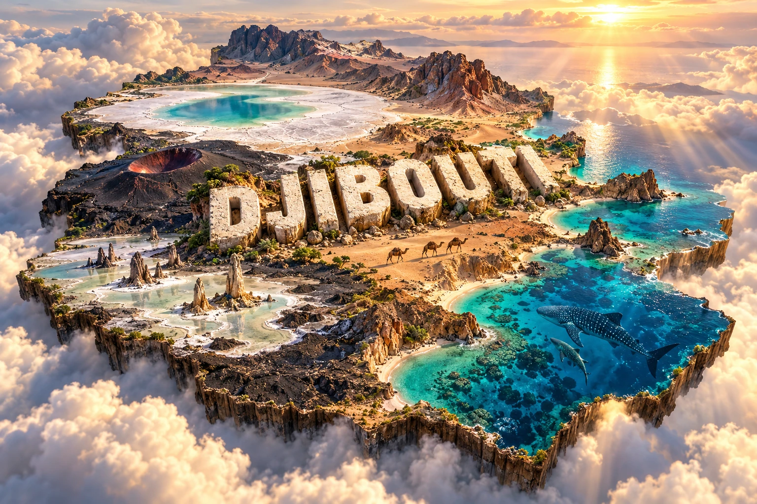
The artwork combines Lake Assal's salt flats, dark volcanic terrain, Lake Abbe's carbonate chimneys, desert mountains, turquoise coastal water, whale sharks and camels. Together these elements represent Djibouti's rift geology, arid pastoral landscapes and marine position at the entrance to the Red Sea.
Each feature belongs in a specific context. Lake Assal and Ardoukôba lie in the central rift zone, while Lake Abbe is on the southwestern border. Whale sharks gather seasonally in parts of the Gulf of Tadjoura; they do not swim in the salt lakes or occur continuously along every shore. Camels shown in the desert are domesticated animals associated with pastoral livelihoods.
The image is a conceptual artistic composition. The landmarks, wildlife and landscapes are combined for educational visualization and are not shown at their true geographic positions or scale.
12. Interesting Facts About Djibouti
- Djibouti borders Eritrea, Ethiopia and Somalia.
- Its coast stands beside the southern gateway to the Red Sea and Suez shipping route.
- Lake Assal's shore is about 155 meters below sea level, the lowest exposed land point in Africa.
- Lake Assal stays salty because it has no surface outlet and evaporation removes water but leaves minerals behind.
- Djibouti lies near the meeting of the Red Sea, Gulf of Aden and East African rift systems.
- Ardoukôba erupted from fissures for about a week in November 1978.
- Lake Abbe's giant towers are carbonate deposits formed around hydrothermal springs, not volcanoes.
- The country has no permanent river.
- Whale sharks gather seasonally in the Gulf of Tadjoura, and many observed animals are immature males.
- The Djibouti francolin is endemic to Djibouti and associated with the Goda Mountains.
- The Addis Ababa–Djibouti railway links landlocked Ethiopia to Djibouti's ports.
- Arabic and French are official, while Somali and Afar are major national languages.
- Djibouti became independent from France in 1977.
- Mousa Ali stands near the meeting of Djibouti, Eritrea and Ethiopia.
- Heat and water scarcity mean the country imports most of its food.
13. Short Quiz
-
Why is Djibouti geologically active? A. It sits near three meeting rift systems B. It lies at the center of a stable ancient shield only C. Its mountains were constructed by people D. Atlantic hurricanes create volcanoes there
-
What makes Lake Assal geographically notable? A. It is Africa's highest lake B. It is the source of the Nile C. Its shore is Africa's lowest exposed land point D. It is a freshwater reservoir with a large outlet
-
How did Lake Abbe's chimneys form? A. Wind piled up sand B. Carbonate precipitated around hydrothermal spring water C. Coral grew above sea level D. People carved volcanic cones
-
Where do whale sharks gather seasonally? A. Lake Assal B. Day Forest C. Gulf of Tadjoura D. Mousa Ali's summit
-
Which sector drives much of Djibouti's economy? A. Alpine forestry B. Port and logistics services C. Large-scale rice farming D. Automobile manufacturing
Answer key: 1-A, 2-C, 3-B, 4-C, 5-B.
14. Related Learning
- Ethiopia Explained: Highlands, Rift Valleys and the Awash River
- Eritrea Explained: Red Sea Coast, Highlands and Culture
- Somalia Explained: Horn of Africa Geography and Indian Ocean Coast
- How the East African Rift Is Pulling a Continent Apart
- Why Lake Assal Is So Salty
- How Lake Abbe's Stone Chimneys Formed
- Why Whale Sharks Gather in the Gulf of Tadjoura
- How the Bab el-Mandeb Connects Global Shipping Routes
- What Is a Tectonic Triple Junction?
- How Desert Pastoralism Adapts to Scarce Rain
15. Sources
- World Bank — Djibouti overview , for current economic and strategic context
- World Bank Data — Djibouti , for dated population and economic indicators
- FAO — Djibouti climate and agriculture profile , for land use, agriculture and climate risks
- FAO GIEWS — Djibouti country brief , for rainfall seasons, pastoral conditions and food security
- Smithsonian Global Volcanism Program — Djibouti volcanoes , for Holocene volcanoes and rift features
- Smithsonian Global Volcanism Program — Ardoukôba , for the 1978 fissure eruption
- Geophysical Research Letters — Lake Abhé hydrothermal system , for the triple-junction setting and underground fluid paths
- Sedimentary Geology — Lake Abhe carbonate towers , for chimney formation and lake-level history
- Conservation — Whale sharks in the Gulf of Tadjoura , for seasonal aggregation and feeding ecology