

Denmark is a low-lying northern European country shaped by ice, sea and human use of the land. The Jutland peninsula and hundreds of islands form a bridge between continental Europe and Scandinavia, while no point is very far from a coast.
Its gentle hills, sandy western shores, sheltered eastern inlets, fertile farmland and white chalk cliffs may seem less dramatic than high mountains, but they preserve an unusually clear story of glaciers, changing sea levels and coastal erosion. Denmark also combines medieval towns and royal sites with modern cities, major shipping routes, wind-energy engineering and everyday bicycle culture.
1. Where Is Denmark?
Denmark lies in northern Europe. Jutland extends north from Germany, Denmark's only land neighbor. To the west is the North Sea; to the north are the Skagerrak and Norway; and to the east are the Kattegat, Øresund, Sweden and the Baltic Sea. Bridges and tunnels link major islands and connect Copenhagen with Malmö in Sweden across the Øresund.
The country includes Jutland and an archipelago of more than 400 named islands. Zealand, or Sjælland, is the largest and contains Copenhagen. Funen, or Fyn, lies between Zealand and Jutland. Other notable islands include Lolland, Falster, Møn, Langeland and Bornholm, which lies farther east in the Baltic.
Denmark is one part of the Kingdom of Denmark, or Danish Realm, together with the self-governing Faroe Islands and Greenland. Unless otherwise stated, this article's land area, population and landscape descriptions refer to Denmark proper, not the much larger ice-covered territory of Greenland or the North Atlantic Faroes.
2. Quick Country Facts
- Official name: Kingdom of Denmark
- Capital: Copenhagen
- Region: Northern Europe and the Nordic region
- Land neighbor: Germany
- Area of Denmark proper: Approximately 42,952 square kilometers
- Population: 6,032,304 in August 2026, according to Statistics Denmark
- Currency: Danish krone (DKK)
- Official language: Danish; Faroese and Greenlandic have official roles in their self-governing territories
- Time zone: Central European Time (UTC+1), with summer daylight saving time (UTC+2); the wider Realm spans other zones
- Highest natural point in Denmark proper: Møllehøj, about 171 meters above sea level
- Longest river: Gudenå
- Largest lake by surface area: Arresø
- Largest island wholly within Denmark: Zealand
- Government: Constitutional monarchy and parliamentary democracy
The population figure is a time-specific register count and should be updated in later editions.
3. Geography and Landscape
Jutland makes up most of Denmark's land, while islands divide the country's eastern waters into straits, bays and fjords. Danish fjords are varied: some are drowned glacial or river valleys, while others are lagoons or inlets separated from the sea by sand barriers. They should not all be imagined as the steep mountain fjords found in Norway.
Western Jutland faces the open North Sea. Waves, tides and storms build and erode long sandy beaches, dunes and spits. The Wadden Sea along the southwest coast contains tidal flats, channels, salt marshes and barrier islands. Large areas are exposed at low tide and submerged again as the tide rises.
Eastern Jutland and the islands generally have more rolling, fertile terrain and indented coasts. The highest hills barely exceed 170 meters, yet glacial ridges, tunnel valleys and kettle holes create local variety. Lakes and wetlands occupy depressions left by ice or influenced by later drainage.
Denmark's white cliffs are especially striking. Møns Klint exposes chalk that was pushed, folded and stacked by glacial action. Stevns Klint exposes chalk and younger limestone separated by a thin boundary layer associated with the asteroid impact and mass extinction at the end of the Cretaceous Period.
Most land has been intensively used. Fields, pastures, towns, transport corridors and planted forests dominate, while fragments of heath, bog, meadow, dune, salt marsh and old woodland preserve distinctive ecosystems.
4. Why Does Denmark Look Like This?
Repeated ice sheets covered Denmark during the Pleistocene ice ages. Moving ice carried clay, sand, gravel and boulders from Scandinavia and the Baltic region. When glaciers slowed or melted, they left till—a mixture of sediment—and built ridges called moraines.
Meltwater flowing beneath and beyond the ice cut valleys and spread sand and gravel across western Jutland. This helps explain why much of the west is flatter and sandier, while younger glacial deposits in eastern Denmark often form rolling, clay-rich and agriculturally productive landscapes.
Blocks of buried ice sometimes remained after the main glacier retreated. When they melted, the surface collapsed into hollows known as kettle holes, some of which became lakes or wetlands. Glaciers also shoved older seabed chalk into steep sheets at Møns Klint. Wave erosion now keeps the cliffs exposed and sometimes triggers landslides.
Sea level rose after the last ice age as global ice melted. Water flooded low valleys and separated higher ground into islands. Since then, currents and waves have continually rearranged sand along the coast. Dunes migrate, spits lengthen, cliffs retreat and storm surges flood low areas unless natural barriers or engineered defenses intervene.
At Stevns Klint, geology tells a much older story. Marine organisms built up chalk on an ancient seabed. A narrow layer records debris linked to the Chicxulub asteroid impact about 66 million years ago, while overlying rocks show recovery after the end-Cretaceous mass extinction.
5. Climate
Denmark has a temperate maritime climate. The surrounding seas and prevailing westerly winds moderate extremes, so winters are generally milder and summers cooler than at similar latitudes deep inside a continent.
Weather changes frequently as Atlantic low-pressure systems cross northern Europe. Rain falls throughout the year, often with windy conditions. Western coasts receive direct exposure to North Sea storms, while some eastern areas are relatively sheltered and drier.
Snow occurs in winter but long-lasting cover is unreliable. Summer days are long because of the northern latitude, while winter daylight is short. Coastal water warms and cools more slowly than land, moderating nearby temperatures.
Climate change is raising sea level and increasing heat and heavy-rain risks. Low coasts, reclaimed land and cities must adapt to storm surges and cloudbursts. Coastal management can involve dunes, dikes, pumping, beach nourishment and decisions about where shorelines should be allowed to move naturally.
6. Wildlife and Ecosystems
Denmark's Wadden Sea is one of its most important ecosystems. Vast numbers of migratory birds use its tidal flats and marshes to feed and rest along the East Atlantic Flyway. Harbor seals and gray seals breed or haul out in suitable coastal areas, but neither occurs along every shore.
Coasts, shallow seas and fjords support fish, porpoises, eelgrass beds and seabirds. The harbor porpoise is Denmark's commonest cetacean and is especially associated with productive straits and coastal waters. Pollution, underwater noise, fishing pressure and oxygen depletion can damage marine habitats.
On land, roe deer, red deer, European badgers, foxes and hares occupy suitable woodland and farmland. Beavers have been reintroduced, and gray wolves returned naturally to Jutland from Germany in the 2010s. Wolves remain few and localized; they are not common throughout Denmark.
Mute swans live on lakes and sheltered coasts and have long cultural associations with Denmark. Other wetlands support geese, ducks, cranes and amphibians. Heathlands in Jutland contain specialized plants, reptiles and insects, while old deciduous woods support fungi, bats and woodland birds.
Centuries of farming, drainage and urban development have reduced many natural habitats. Restoration projects now recreate wetlands, reconnect streams, allow some forests to develop more naturally and reduce nutrient runoff. Agricultural nutrients can still contribute to algal growth and low oxygen in coastal waters.
7. Famous Landmarks and Natural Features
Copenhagen's historic center and waterfront reflect the city's growth beside the Øresund shipping route. Nyhavn's colored townhouses began around a commercial canal, while modern harbor districts show the shift from industry toward mixed urban uses. The city is also known for cycling infrastructure, but bicycles belong to a working transport system rather than decorative folklore.
Jelling's mounds, runic stones and church mark the transition between pre-Christian Nordic traditions and the Christian Danish kingdom in the tenth century. UNESCO describes the complex as an exceptional record of political and religious change.
Kronborg Castle stands at Helsingør near the narrow entrance to the Baltic. Its location helped Danish kings control shipping and collect the historic Sound Dues. The castle later became internationally associated with Shakespeare's Hamlet, although the play's story is literary rather than a record of events at Kronborg.
Roskilde Cathedral contains royal tombs and demonstrates centuries of brick architecture. Nearby, the Viking Ship Museum preserves vessels excavated from Roskilde Fjord and explains maritime technology through archaeology and reconstruction.
Stevns Klint preserves evidence connected to the end-Cretaceous asteroid impact and the recovery of marine life afterward. Møns Klint, newly inscribed on the World Heritage List in 2025, displays glacially deformed chalk cliffs above the Baltic.
The Wadden Sea is a shared World Heritage property extending across Denmark, Germany and the Netherlands. Its tidal flats are globally important for migratory birds and continually reshaped by tides and sediment.
The Viking-Age ring fortresses are a group of precisely planned circular strongholds associated with the consolidation of royal power under Harald Bluetooth. They are archaeological sites, not surviving medieval castles with intact walls.
8. People, Languages and Culture
Danish is the national language and belongs to the North Germanic group with Swedish, Norwegian, Icelandic and Faroese. German has minority-language protection in southern Jutland. Many residents also use English and languages brought through migration.
Denmark's population is culturally diverse. National identity, regional identities and the identities of Greenlanders, Faroese, the German minority and newer communities overlap in different ways. The wider Realm is a constitutional relationship among distinct societies, not evidence that Danish culture represents all Greenlandic or Faroese people.
The Danish monarchy has roots extending back more than a millennium, but modern political authority rests in a parliamentary democracy under the constitution. Denmark joined what became the European Union in 1973 but retains the krone rather than adopting the euro.
Viking-age seafaring is important history, yet it covers only part of Denmark's past. Later periods include medieval church building, Renaissance monarchy, agricultural reform, industrialization, the development of labor movements and the welfare state, German occupation during the Second World War, and postwar European cooperation.
Design and architecture are associated with figures such as Arne Jacobsen and Jørn Utzon, but Danish creativity also includes literature, film, music, crafts and contemporary multicultural expression. Writer Hans Christian Andersen gave fairy tales new literary forms. The idea of hygge generally suggests comfortable sociability, but it is an everyday concept rather than a complete explanation of Danish society.
9. Food
Smørrebrød consists of open-faced rye-bread sandwiches topped with carefully combined ingredients such as herring, egg, potato, meat or cheese. It ranges from simple lunches to highly arranged restaurant versions.
Rugbrød, dense rye bread, is a staple. Pickled herring reflects maritime preservation traditions, while frikadeller are pan-fried meatballs with household and regional variations. Flæskesteg is roast pork commonly associated with festive meals.
Denmark is also known for dairy products and baking. The pastry called “Danish” in English is known in Denmark as wienerbrød, meaning Vienna bread, a reminder that foods often cross borders. New Nordic cuisine has influenced restaurants by emphasizing seasonality and regional ingredients, but it does not describe everyday food for everyone.
10. Economy and Major Industries
Denmark has a high-income, trade-oriented economy in which services provide most jobs and output. Major activities include business services, finance, public services, retail, information technology, transport and logistics.
Shipping is globally significant because Danish companies manage large container and maritime networks. Manufacturing includes pharmaceuticals, industrial machinery, food processing, chemicals, furniture, medical equipment and wind-energy technology. Research-intensive companies connect Denmark to international supply chains.
Agriculture uses a large share of the land and is highly mechanized. Cereals, pigs, dairy cattle, oilseed and other products support food processing and exports. High output also creates environmental pressures through greenhouse-gas emissions, nutrient runoff and intensive land use.
Wind power is central to Denmark's energy transition and engineering sector. The Danish Energy Agency reported that wind supplied 54 percent of domestic electricity supply in 2024. Because wind output varies, interconnectors, flexible demand, storage, other generators and power markets help balance the system.
The North Sea has historically supplied oil and gas, while policy increasingly emphasizes renewable energy and lower emissions. Denmark's economy grew 2.9 percent in 2025 according to current World Bank data, but such indicators change and should be refreshed in future editions.
11. What the 3D Visual Represents
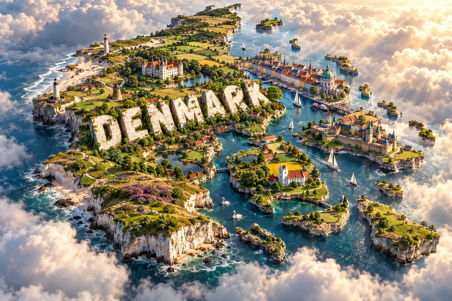
The artwork combines a Copenhagen-inspired colorful waterfront, historic castles, windswept coasts, green farmland, white cliffs, bicycles and swans. The waterfront and bicycles suggest urban Denmark; castles and historic buildings evoke royal and maritime history; fields represent intensive agriculture; and cliffs and coasts point to glaciation, chalk geology and constant interaction with the sea.
These features belong to different places and contexts. White cliffs are especially associated with Møn and Stevns, while exposed sandy shores and dunes characterize much of western Jutland. Swans occur on suitable lakes and coasts rather than everywhere. The image's country outline also simplifies Denmark's many separated islands.
The image is a conceptual artistic composition. The landmarks, wildlife and landscapes are combined for educational visualization and are not shown at their true geographic positions or scale.
12. Interesting Facts About Denmark
- Denmark proper consists of Jutland and more than 400 named islands.
- Germany is Denmark's only land neighbor, although bridges and tunnels connect it to Sweden.
- Copenhagen and Malmö form a cross-border urban region around the Øresund.
- Denmark's highest natural point, Møllehøj, is only about 171 meters above sea level.
- Ice sheets created many of the country's hills, valleys, soils and lakes.
- Møns Klint's chalk was thrust and folded by glacial pressure.
- Stevns Klint preserves a rock layer linked to the asteroid impact at the end of the age of non-avian dinosaurs.
- The Wadden Sea alternates between exposed tidal flats and submerged seabed.
- Denmark, Greenland and the Faroe Islands together form the Kingdom of Denmark.
- Jelling's monuments document a transition from Nordic pagan traditions to Christianity.
- Kronborg's position helped control the narrow sea route into and out of the Baltic.
- Gray wolves returned naturally to Jutland after being absent for roughly two centuries.
- The Øresund connection includes both a bridge and a tunnel.
- Denmark joined the European Union's predecessor in 1973 but continues to use the Danish krone.
- Wind supplied more than half of Denmark's domestic electricity supply in 2024.
13. Short Quiz
-
What is Denmark's only land neighbor? A. Sweden B. Norway C. Germany D. Poland
-
Which process shaped much of Denmark's modern landscape? A. Recent continental collision B. Repeated glaciation C. Tropical volcanism D. Desert dune migration alone
-
What does the thin layer at Stevns Klint help record? A. The end-Cretaceous asteroid impact B. The first Viking voyage C. A modern oil spill D. The construction of Copenhagen
-
Which places form the Kingdom of Denmark? A. Denmark, Iceland and Norway B. Denmark, Greenland and the Faroe Islands C. Denmark, Sweden and Finland D. Denmark and Germany only
-
Why is the Wadden Sea important to many birds? A. Its tidal flats provide feeding and resting habitat B. It is Denmark's highest mountain habitat C. It never changes with the tide D. It is entirely covered by forest
Answer key: 1-C, 2-B, 3-A, 4-B, 5-A.
14. Related Learning
- Germany Explained: Rivers, Lowlands, Industry and Culture
- Sweden Explained: Forests, Lakes, Islands and Nordic Culture
- Norway Explained: Fjords, Mountains and the North Atlantic
- How Ice Sheets Shaped Northern Europe
- Why Denmark Has So Many Islands
- How the Wadden Sea Changes with Every Tide
- What Stevns Klint Reveals About the Dinosaur Extinction
- How Offshore Wind Farms Generate Electricity
- Greenland Explained: Ice Sheet, Fjords and Inuit Culture
- Faroe Islands Geography: Volcano-Built Islands in the North Atlantic
15. Sources
- Statistics Denmark — Population figures , for the dated resident population
- Official Denmark website — Danish nature , for islands, coastline and natural-landscape context
- Geological Survey of Denmark and Greenland — Møns Klint geology , for chalk, ice advances and glacial deformation
- UNESCO World Heritage Centre — Denmark , for current World Heritage properties
- UNESCO — Jelling Mounds, Runic Stones and Church , for the site's history and significance
- UNESCO — Stevns Klint , for the end-Cretaceous boundary and fossil record
- UNESCO — Møns Klint , for its glaciotectonic landscape and habitats
- Danish Energy Agency — Wind Energy: Powering the Future , for wind's 2024 electricity contribution
- World Bank Data — Denmark , for current economic indicators