

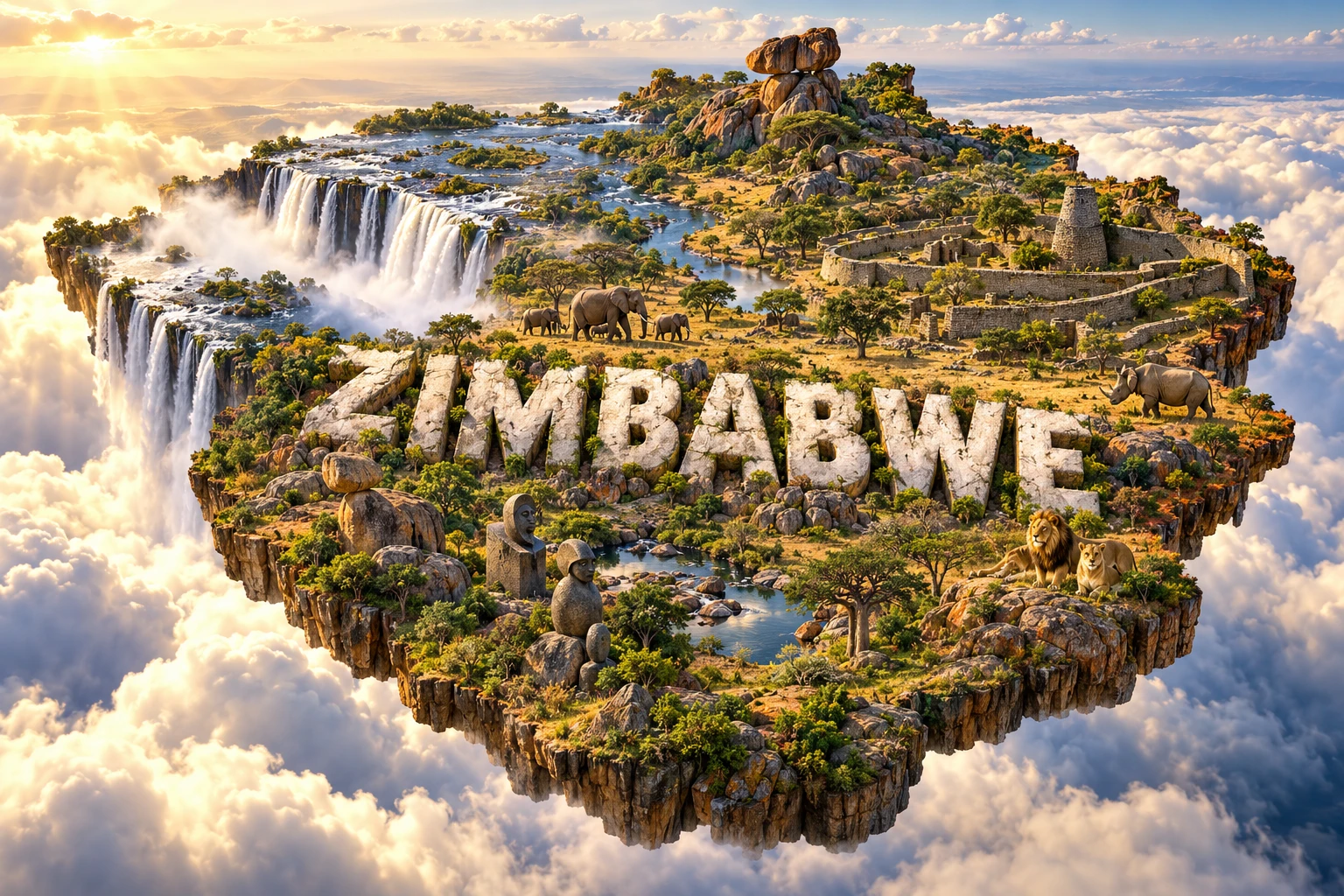
Zimbabwe is a landlocked southern African country of high plateaus, granite landscapes, major river valleys and dry woodland. Its name comes from Great Zimbabwe, the stone-built centre of a powerful medieval state. The same country also shares Mosi-oa-Tunya/Victoria Falls, protects Zambezi floodplains rich in wildlife and contains the mineral-bearing Great Dyke. Geography connects these natural, cultural and economic stories.
1. Where Is Zimbabwe?
Zimbabwe lies in Southern Africa. Zambia borders it to the north, Mozambique to the east, South Africa to the south and Botswana to the west. The Zambezi forms much of the northern boundary, while the Limpopo marks a large part of the southern border. Zimbabwe has no coastline.
Harare, the capital and largest city, stands on the Highveld in the northeast-central region. Bulawayo is the principal city of the southwest. Mutare lies near the Eastern Highlands, Masvingo is close to Great Zimbabwe, and the town of Victoria Falls stands beside the shared waterfall and Zambezi gorges.
Near Kazungula, Zimbabwe approaches Namibia, Botswana and Zambia, but accepted boundaries do not create one exact four-country point. Short distances on maps should not be mistaken for a border Zimbabwe–Namibia border.
2. Quick Country Facts
| Fact | Detail |
|---|---|
| Official name | Republic of Zimbabwe |
| Capital | Harare |
| Region | Southern Africa |
| Area | About 390,800 square kilometres |
| Population | About 17 million in 2025 estimates |
| Currency | Zimbabwe Gold (ZiG), alongside an authorized multicurrency system; arrangements can change |
| Official languages | The constitution recognizes 16 official languages |
| Time zone | Central Africa Time, UTC+2 |
| Highest point | Mount Nyangani, 2,592 metres |
| Major rivers | Zambezi, Limpopo, Save and Runde |
| Independence | 18 April 1980 |
Population, prices and currency rules can change quickly. An evergreen article should date precise economic figures and verify monetary arrangements before future publication updates.
3. Geography and Landscape
Much of Zimbabwe lies on a broad interior plateau. The Highveld, generally above 1,200 metres, runs diagonally from southwest to northeast and includes Harare. Lower plateaus called the Middleveld step down on either side, followed by the hotter Lowveld in the Zambezi and Limpopo drainage basins.
Along the eastern border, the Eastern Highlands form a cooler, wetter belt of mountains and escarpments. Mount Nyangani is the highest point. The range includes forests, grasslands, waterfalls and deep valleys extending toward Mozambique.
In the west and northwest, Kalahari sands, teak woodland and savanna surround Hwange. The southeast is drier and includes mopane woodland and the broad valleys of the Save and Runde. In the north, the Zambezi supports Lake Kariba, floodplains, escarpments and Mana Pools.
Granite covers extensive parts of the plateau. Rounded hills, bare domes, boulder piles and balancing rocks are particularly striking around Matobo and near Harare. These landforms are not human-built: they are the exposed remains of deeply weathered bedrock.
4. Why Does Zimbabwe Look Like This?
Zimbabwe's plateau rests on ancient continental crust. Long periods of uplift and erosion stripped away overlying material and left broad elevated surfaces. Rivers then cut valleys toward the Zambezi in the north and Limpopo in the south, with drainage divides crossing the central highlands.
The famous granite kopjes formed through weathering along underground joints. Water altered blocks beneath the soil, rounding their corners. Later erosion removed the weathered material and exposed resistant cores as stacked boulders. Some appear precariously balanced, but their shapes record slow chemical weathering and surface erosion.
The Great Dyke is a long, narrow body of igneous rock running roughly north–south through the country. Magma intruded ancient crust about 2.6 billion years ago and cooled in layers. Those layers concentrated chromium, platinum-group metals and other minerals, influencing modern mines and transport.
At Mosi-oa-Tunya/Victoria Falls, the Zambezi crosses ancient basalt. Water exploits cracks and cuts narrow gorges, causing the waterfall edge to retreat upstream. Below the present falls, zigzag gorges mark previous positions. This is why the waterfall and gorge system is an active geological landscape.
5. Climate
Zimbabwe has a subtropical climate strongly influenced by elevation. The Highveld is milder than the low-lying Zambezi and Limpopo valleys. The Eastern Highlands are coolest and generally wettest, while the southwest and southern Lowveld are hotter and drier.
Most rain falls during the warm season from roughly November to March, when tropical moisture and the Intertropical Convergence Zone influence the region. May to August is dry and cooler, with cold nights and occasional frost on the plateau. September and October are often very hot before the rains begin.
Rainfall varies greatly from year to year. El Niño often raises drought risk in southern Africa, while La Niña can favor wetter conditions, though neither guarantees one outcome. Drought affects rain-fed maize, livestock, drinking water and hydroelectric generation at Kariba. Intense storms can cause floods, erosion and infrastructure damage.
Climate change is increasing heat and rainfall uncertainty. Farmers adapt through drought-tolerant crops, conservation agriculture, water harvesting, irrigation where sustainable and better forecasts. Protecting woodland and wetlands also helps soils retain water.
6. Wildlife and Ecosystems
Zimbabwe's habitats include miombo and mopane woodland, savanna, Eastern Highland forest and grassland, dry Lowveld, riverine forest and Zambezi floodplain. Animals shown in national imagery occupy particular habitats and protected areas, not every district.
Hwange National Park, the country's largest, protects teak and mopane woodland and grassland. It supports elephants, lions, African wild dogs, buffalo and many antelope. Artificial water points sustain wildlife through the dry season but also change natural movement and grazing patterns.
Mana Pools lies along the lower Zambezi. Seasonal channels and old river pools attract elephants, hippos, crocodiles and birds as water recedes. The UNESCO property includes Mana Pools National Park plus Sapi and Chewore safari areas. Across the river, habitats connect with Zambia's Lower Zambezi region.
Black and white rhinos survive in intensively protected populations, including in the Matobo region and private or public conservation areas. Poaching remains a threat. Gonarezhou forms part of the Great Limpopo Transfrontier Conservation Area with Mozambique and South Africa, allowing some wildlife movement across borders.
Habitat loss, wildfire, mining impacts, drought and conflict between people and large animals create continuing challenges. Conservation works best when local communities share decision-making and tangible benefits.
7. Famous Landmarks and Natural Features
Great Zimbabwe National Monument preserves stone enclosures, hill ruins and a valley settlement built mainly between the eleventh and fifteenth centuries. It was a political and trading centre connected through regional networks to the Indian Ocean. Its dry-stone walls were constructed without mortar. Colonial writers once denied African authorship, but archaeological evidence firmly establishes it as an African achievement.
Mosi-oa-Tunya/Victoria Falls is shared with Zambia. The Zambezi, more than 1.7 kilometres wide at the falls in UNESCO's description, drops into a narrow basalt gorge and creates immense spray. It is celebrated for the scale of its water curtain, not because it is the world's tallest waterfall.
Matobo Hills combine granite kopjes, rock shelters with extensive paintings and places of continuing spiritual importance. The landscape is a UNESCO cultural property because geology, archaeology and living traditions are interconnected.
Khami Ruins, west of Bulawayo, developed after Great Zimbabwe declined and uses decorated retaining walls and terraced platforms. It demonstrates continuity and innovation in later states rather than a copy of one earlier city.
Mana Pools, Sapi and Chewore protect an important Zambezi floodplain and escarpment ecosystem. The Eastern Highlands, including Nyanga and Chimanimani, offer a contrasting landscape of high grasslands, forest, cliffs and waterfalls.
8. People, Languages and Culture
Zimbabwe's constitution recognizes 16 official languages, including Chewa, Chibarwe, English, Kalanga, Koisan, Nambya, Ndau, Ndebele, Shangani, Shona, sign language, Sotho, Tonga, Tswana, Venda and Xhosa. Shona languages are spoken by a majority, while Ndebele is especially important in the southwest. No language list should obscure smaller communities or multilingual urban life.
The plateau supported farming, herding, gold production and trade long before European colonization. Great Zimbabwe and successor states such as Mutapa and Torwa connected inland resources to wider networks. Ndebele state formation shaped the southwest in the nineteenth century. British company rule and settler colonialism created Southern Rhodesia, dispossessing African communities of land.
After a long liberation struggle and the 1979 Lancaster House settlement, internationally recognized independence came in 1980. Political violence, including the Gukurahundi killings of the 1980s, is important historical context and should not be erased from a neutral educational account.
Stone sculpture, basketry, pottery, textiles, mbira music, dance, praise poetry and storytelling represent diverse regional traditions. The mbira dzavadzimu, metal keys mounted on a wooden soundboard and played inside a resonator, is important in some Shona spiritual and musical contexts. Contemporary gospel, sungura, hip-hop and other styles are equally part of modern culture.
9. Food
Sadza, a thick porridge commonly made from maize meal, is a staple served with leafy vegetables, beans, meat, fish or sauces. Maize became dominant during comparatively recent history; sorghum and millet remain valuable, especially in drier areas.
Muriwo unedovi combines leafy greens with groundnut paste. Dovi refers to peanut-based preparations used in vegetables, meat or chicken dishes. Mopane worms, the caterpillars of emperor moths, are harvested seasonally in parts of southern Africa and may be dried or cooked; they are not eaten by every Zimbabwean.
Regional foods reflect Ndebele, Shona, Tonga, Kalanga and other traditions, as well as urban and diaspora influences. Cattle, goats, beans, pumpkins, wild fruits and fish matter differently by environment and household.
10. Economy and Major Industries
Mining is a major source of exports. Gold, platinum-group metals, chromium, nickel, coal, diamonds and lithium are important, with the Great Dyke hosting many deposits. Mining can generate employment and revenue but also brings land, water, labour and transparency challenges.
Agriculture supports livelihoods and supplies industry. Farmers grow maize, tobacco, cotton, sugar cane, horticultural crops and small grains and raise livestock. Much farming is rain-fed, so drought causes large swings in harvests and rural incomes. Irrigation can reduce risk where energy and water are reliable.
Manufacturing includes food processing, beverages, metals, chemicals and textiles. Services include wholesale and retail trade, finance, telecommunications, transport and tourism. Remittances from Zimbabweans abroad support many households.
The economy has experienced repeated inflation, currency changes, debt constraints and widespread informal work. Zimbabwe Gold, or ZiG, was introduced in 2024, while approved foreign currencies continued circulating under a multicurrency framework. Because policy changes, no currency description should be treated as permanent without rechecking.
Electricity comes from Kariba hydropower, thermal plants and growing solar capacity. Drought can lower Kariba generation, while aging equipment and demand create shortages. Economic resilience depends on more reliable power, climate-smart agriculture and responsible mineral development.
11. What the 3D Visual Represents
The Zimbabwe artwork combines Mosi-oa-Tunya/Victoria Falls, Great Zimbabwe-inspired stone walls, balancing rocks, Matobo-style granite hills, savanna, elephants, lions and rhinos, with decorative motifs inspired broadly by Shona art. These symbolize river erosion, medieval statecraft, granite weathering, diverse artistic traditions and protected wildlife.
The image is a conceptual artistic composition. Victoria Falls is shared with Zambia; Great Zimbabwe and Matobo are separate places; and elephants, lions and rhinos occupy localized habitats rather than the entire country. “Shona motifs” cannot represent all Zimbabwean communities. Elements are combined for educational visualization and are not shown at their true positions, abundance or scale. The artwork is not a satellite map or archaeological reconstruction.
12. Interesting Facts About Zimbabwe
- Zimbabwe is landlocked between Zambia, Mozambique, South Africa and Botswana.
- The country's name derives from Great Zimbabwe.
- Great Zimbabwe's monumental walls were built without mortar.
- Archaeology demonstrates that Great Zimbabwe was an African-built city and trading centre.
- The Highveld's elevation makes it cooler than the Zambezi and Limpopo lowlands.
- Mount Nyangani is the highest point at 2,592 metres.
- Balancing rocks form through joint-controlled granite weathering and erosion.
- The Great Dyke is an ancient igneous intrusion rich in mineral deposits.
- Mosi-oa-Tunya/Victoria Falls is shared with Zambia.
- The zigzag Batoka Gorges mark earlier positions of the retreating falls.
- Mana means “four” in Shona and refers to four principal pools at Mana Pools.
- Zimbabwe's constitution recognizes 16 official languages.
- Black and white rhinos are distinct species, and both require strong protection.
- Zimbabwe attained internationally recognized independence in 1980.
- UNESCO lists five World Heritage properties in Zimbabwe.
13. Short Quiz
-
What kind of landscape dominates much of Zimbabwe? A. Low coral atolls B. An elevated interior plateau C. Polar ice sheet D. Coastal delta
-
How did many balancing rocks form? A. Slow granite weathering and erosion B. Coral growth C. Glacier transport from Europe D. Recent brick construction
-
What is the Great Dyke? A. A modern canal B. An ancient mineral-bearing igneous intrusion C. A river delta D. A sandstone dune
-
Why is Great Zimbabwe historically important? A. It was a medieval African political and trading centre B. It was built as a twentieth-century theme park C. It is the source of the Nile D. It is a volcanic crater
-
Why is the 3D visual not a literal map? A. Zimbabwe is an island B. It combines separate landmarks and localized wildlife at invented scales C. The country has no stone ruins D. All animals live at Victoria Falls
Answer key: 1-B, 2-A, 3-B, 4-A, 5-B.
14. Related Learning
- Zambia Explained: The other side of Victoria Falls
- Botswana Explained: Kalahari environments and wildlife corridors
- Mozambique Explained: Eastern Highlands and shared river basins
- South Africa Explained: Zimbabwe's southern neighbor
- How Great Zimbabwe's Dry-Stone Walls Were Built
- Why Balancing Rocks Form in Granite Landscapes
- How Victoria Falls Retreats Upstream
- How the Great Dyke Concentrated Valuable Minerals
- Why Mana Pools Change with the Zambezi's Seasons
- How Altitude Shapes Zimbabwe's Climate
These are internal-link topics or article-title suggestions. Confirm that a page exists before assigning a URL.
15. Sources
- Zimbabwe National Statistics Agency
- World Bank — Zimbabwe overview
- World Bank Data — Zimbabwe
- UN Data — Zimbabwe country profile
- UNESCO World Heritage Centre — Zimbabwe
- UNESCO — Great Zimbabwe National Monument
- UNESCO — Matobo Hills
- UNESCO — Mana Pools, Sapi and Chewore
- UNESCO — Mosi-oa-Tunya/Victoria Falls
- Zimbabwe Parks — Hwange National Park
- Zimbabwe Parks — Mana Pools National Park
- FAO — Zimbabwe country profile
- Convention on Biological Diversity — Zimbabwe profile
- Encyclopaedia Britannica — Zimbabwe