

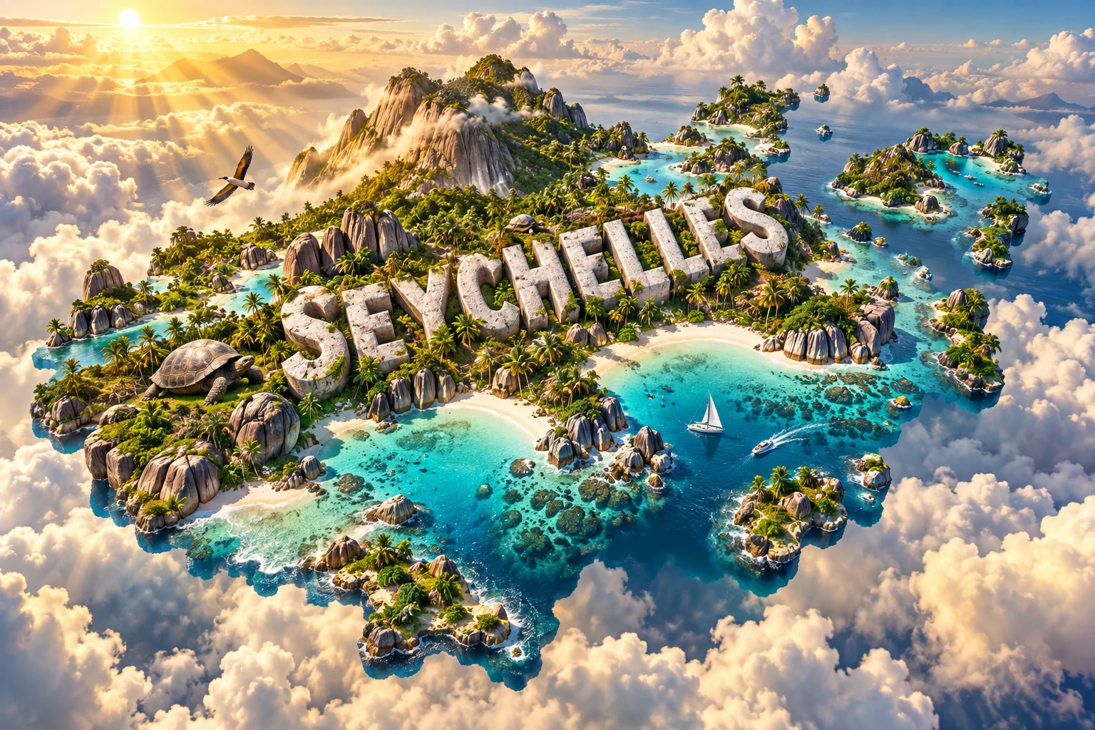
Seychelles is a western Indian Ocean nation whose 115 islands reveal two geological stories. Mahé, Praslin, La Digue and other inner islands are exposed peaks of an ancient granitic microcontinent. Most outer islands are coral cays and atolls built by reefs on submerged banks.
This contrast explains the country's rounded granite boulders, steep forested interiors, shallow lagoons and enormous marine territory. Long isolation also produced plants and animals found nowhere else, including the coco de mer palm and several island birds. Seychelles is more than a beach landscape: it is a living record of continental breakup, reef growth, evolution and Creole history.
1. Where Is Seychelles?
Seychelles is an African island country in the western Indian Ocean, northeast of Madagascar and east of mainland East Africa. Its nearest island neighbors include the Comoros and Mayotte to the southwest, Madagascar to the south, Mauritius and Réunion to the southeast, and the Maldives far to the northeast.
The republic comprises 115 islands spread across a very large ocean area. The inner islands cluster around the shallow Seychelles Bank. Farther south and southwest lie outer groups including the Amirantes, Alphonse, Farquhar and Aldabra.
Mahé is the largest and most populous island. Victoria, the capital, occupies its northeast coast and is one of the world's smallest national capitals. Praslin and La Digue are the next best-known inhabited granitic islands. Many outer islands are uninhabited, sparsely staffed or managed for conservation and limited economic activity.
Seychelles has no land borders. Its land area is tiny compared with an exclusive economic zone of roughly 1.35 million square kilometres, making ocean management central to national life.
2. Quick Country Facts
- Official name: Republic of Seychelles
- Capital: Victoria, on Mahé
- Region: Western Indian Ocean; Africa
- Islands: 115
- Land area: Approximately 446 square kilometres
- Population: 119,878 in the 2022 population and housing census
- Currency: Seychelles rupee (SCR)
- Official languages: Seychellois Creole, English and French
- Time zone: Seychelles Time, UTC+4, year-round
- Highest point: Morne Seychellois, 905 metres, on Mahé
- Largest island: Mahé
- Independence: 29 June 1976, from Britain
- World Heritage properties: Aldabra Atoll and Vallée de Mai Nature Reserve
Around three-quarters of residents live on Mahé. Population estimates differ from the 2022 census as migration and annual demographic change are incorporated, so every figure needs a date.
3. Geography and Landscape
The inner granitic islands are mountainous despite their small size. Mahé rises steeply from a narrow coastal strip to Morne Seychellois. Short streams drain forested slopes, while most settlement, roads and reclaimed land occupy the coast. Praslin and La Digue have lower ridges and conspicuous granite outcrops.
Weathering has rounded and separated granite along natural fractures, producing the enormous pale boulders associated with beaches such as Anse Source d'Argent. Sand accumulates where waves and reefs create suitable conditions; not every coast is a wide white beach. Some shores are rocky, muddy or lined with mangroves.
The outer islands are mostly coral limestone and sand, often only a few metres above sea level. Atolls form rings or arcs around lagoons, while sand cays shift with currents and storms. Aldabra consists of four main raised coral islands enclosing a large shallow lagoon connected to the sea by channels.
Coral reefs surround many islands and reduce wave energy. Lagoons contain seagrass beds, patch reefs and sandy bottoms. Mangroves occupy sheltered tidal areas. These habitats support fish, turtles, seabirds and invertebrates and protect coasts, although their condition varies by island.
Freshwater is limited. The granitic islands collect rain in streams, reservoirs and groundwater, while small coral islands have thin freshwater lenses that can be contaminated by salt. Desalination increasingly supports demand during dry periods.
Large distances make the country difficult to represent as one map-shaped island. The recognizable outline in an artwork is symbolic: Seychelles is a dispersed archipelago rather than a single continuous landmass.
4. Why Does Seychelles Look Like This?
The granitic islands are fragments of continental crust rather than volcanoes or reef-built islands. Their rocks formed mostly around 750 million years ago. They were once joined within ancient supercontinents and later became part of the landmass connecting Madagascar and India.
As Gondwana broke apart, Madagascar separated from the India–Seychelles block. Around 65 million years ago, seafloor spreading between India and Seychelles carried India rapidly northeast while leaving the Seychelles microcontinent isolated. Most of that continental block now lies underwater; its high points emerge as the granitic islands.
Tropical chemical weathering attacks minerals along fractures. Feldspar turns to clay, while more resistant quartz-rich granite remains. Rounded blocks develop below ground and are later exposed as softer weathered material is removed. Waves then rework the coast around them.
The outer islands formed differently. Reef-building corals and other organisms produced calcium-carbonate skeletons in warm, shallow, sunlit water. As generations accumulated and waves broke the material into sand, reefs and cays developed on submarine banks. Changes in sea level sometimes exposed and dissolved reef limestone, creating Aldabra's rugged raised surface.
Reefs require a narrow environmental range. Heat stress can cause coral bleaching, when corals lose the algae that provide much of their energy and color. Severe or repeated bleaching can kill reefs, although recovery varies with species, local conditions and time between events.
Isolation drove evolution. Ancestors arriving by flight, rafting or ocean currents became separated from mainland populations. Over many generations some evolved into endemic species. That same small range makes island wildlife unusually vulnerable to fire, habitat loss, invasive species and disease.
5. Climate
Seychelles has a warm, humid tropical climate moderated by the ocean. Temperatures change less through the year than in continental climates, but rainfall and wind vary seasonally and among islands.
From roughly November to March, the northwest monsoon brings warm, moist air, lighter winds and frequent rain. December and January are often among the wettest months on the granitic islands. Short intense downpours can cause floods and landslides on steep Mahé.
The southeast trade-wind season, generally May to October, is cooler, windier and drier. July and August often have rougher seas on exposed southeastern coasts. April and October are transition periods when winds may be light and variable.
Mahé's mountains force air upward and create local rainfall differences. Outer islands at other latitudes and without high relief follow different patterns. The main granitic islands lie outside the usual tropical-cyclone belt, but distant storms can still produce heavy swell, wind and rain; southern outer islands face greater cyclone risk.
Climate change raises sea level, ocean heat and acidity. Low coral islands face flooding, erosion and salt contamination, while all islands face reef bleaching and water stress. Even on high granitic islands, most homes, infrastructure and economic activity crowd narrow coastal zones.
6. Wildlife and Ecosystems
Seychelles has exceptional endemism. Granitic-island forests contain palms, pandanus, reptiles, amphibians and birds whose ancestors evolved in isolation. However, plantation clearing and introduced cinnamon, albizia and other plants transformed much native forest.
The coco de mer grows naturally only on Praslin and Curieuse. Its enormous double-lobed nut contains the largest seed in the plant kingdom. Vallée de Mai protects palm forest where all six endemic Seychelles palm species occur together. The endemic Seychelles black parrot depends on Praslin's palm-forest landscape.
The Aldabra giant tortoise is native to Aldabra, which supports the world's largest wild population—about 152,000 in UNESCO's description. Tortoises have also been introduced or restored to other managed islands, but an artwork should not imply that wild herds occur on every beach.
Conservation programs have helped recover birds once close to extinction, including the Seychelles magpie-robin, Seychelles warbler and Seychelles white-eye. Their recovery involved habitat restoration, predator control and moving individuals to safe islands. Species remain island-specific rather than evenly distributed.
Marine life includes green and hawksbill turtles, reef fish, sharks, rays, dolphins, whales and seabirds. Aldabra is an important green-turtle nesting area, while hawksbills nest on several granitic islands. Nesting is seasonal and concentrated on suitable beaches.
Invasive rats, cats, barn owls, plants and invertebrates threaten native species. Biosecurity and island restoration can be unusually effective because pests can sometimes be removed from an entire small island. Climate change, plastic, pollution and unsustainable fishing operate across much wider waters and demand regional cooperation.
7. Famous Landmarks and Natural Features
- Aldabra Atoll is one of the world's largest raised atolls. Its remote lagoon, coral limestone, mangroves, turtles, seabirds and giant tortoises make it an outstanding natural laboratory; access is tightly controlled.
- Vallée de Mai, on Praslin, preserves a rare palm forest dominated by coco de mer. It is only 19.5 hectares and depends on the surrounding Praslin National Park for ecological protection.
- Morne Seychellois National Park covers highland forest on Mahé and contains the country's 905-metre summit, water catchments and endemic habitat.
- Anse Source d'Argent, on La Digue, is known for weathered granite boulders, reef-sheltered shallows and sand. Its appearance changes with tide, light and coastal processes.
- Curieuse Island supports naturally occurring coco de mer and a managed population of Aldabra giant tortoises. Its mangroves and former leprosy-station buildings add ecological and historical layers.
- Victoria contains the market, clock tower, places of worship and civic buildings reflecting a compact, multicultural capital.
- Mission Lodge at Venn's Town preserves ruins of a nineteenth-century school connected to children liberated from slave ships. Its history requires attention to abolition, empire and individual lives, not scenery alone.
- Sainte Anne Marine National Park protects islands and marine habitat near Mahé, illustrating both the value and visitor pressure of near-urban reefs.
Seychelles has two UNESCO World Heritage properties, both natural. Beaches and individual granite formations may be globally recognizable without being World Heritage sites.
8. People, Languages and Culture
The islands had no permanent Indigenous population before European settlement. Arab, Asian and European sailors knew the western Indian Ocean, but France began a lasting colony in 1770. Settlers brought enslaved people mainly from Africa and Madagascar to work plantations.
Britain took formal control under the Treaty of Paris in 1814 and governed Seychelles from Mauritius until it became a separate crown colony in 1903. After abolition, the British intercepted some slave-trading vessels and placed liberated Africans in Seychelles, adding to the developing population.
The country became independent in 1976. A 1977 coup led to one-party rule, which lasted until constitutional reform restored multiparty politics in 1993. Later elections included the first peaceful transfer of presidential power between parties in 2020 and another transfer following the 2025 election.
Seychellois Creole, or Kreol Seselwa, developed largely from French vocabulary with African and other influences and has its own standardized grammar and spelling. It is an official language alongside English and French. Creole is widely spoken at home and in public life; English and French remain important in education, administration, media and international exchange.
Seychellois culture emerged through African, Malagasy, European and Asian histories. This blending is visible in language, food, music, dance, family traditions and religion, but “Creole” does not mean that everyone has the same ancestry or beliefs.
Music and dance include moutya, historically developed among enslaved Africans around percussion, song and movement. UNESCO added moutya to its intangible heritage list in 2021. Sega, kanmtole and contemporary genres also have audiences. Performances for visitors should not be mistaken for the whole of daily culture.
Roman Catholic Christianity is the majority tradition, with Anglican, other Christian, Hindu, Muslim and other communities. Public festivals, neighborhood life and modern creative work coexist with the heritage imagery of wooden houses, fishing boats and plantation-era buildings.
9. Food
Fish is central to Seychellois cuisine. Tuna, bonito, red snapper, jobfish and other species may be grilled, curried or served with rice. Octopus curry uses coconut milk and spices, while fish curry may include tamarind, chilies, ginger and garlic.
Satini is a grated or finely prepared salad or relish made from ingredients such as green papaya, aubergine or fish, often with lime and chili. Ladob can be savory or sweet: banana, breadfruit or cassava is cooked with coconut milk, sugar and spices in dessert versions.
Breadfruit, cassava, sweet potato, plantain, coconut, tropical fruit and rice reflect island cultivation and trade. Much food is imported because land is scarce and the population is concentrated on mountainous islands.
Food carries African, French, Indian and Chinese influences, but recipes vary among families. Sustainability matters because seafood consumption, exports and tourism all place demand on marine resources.
10. Economy and Major Industries
Seychelles is classified by the World Bank as a high-income economy and has Africa's highest income per person by some measures. That average does not eliminate inequality, high living costs or household vulnerability.
Tourism is a central source of employment, foreign exchange and business for hotels, restaurants, transport and conservation sites. Dependence on international flights and distant markets makes the economy vulnerable to pandemics, recessions and geopolitical disruption.
Fishing is the other major pillar. Industrial tuna fishing and processing connect Victoria with fleets and markets across the Indian Ocean, while artisanal fishers supply local food. Sustainable catch limits, monitoring, labor standards and healthy reefs are essential to long-term value.
Government services, construction, retail, communications, finance and professional activities also contribute. Agriculture is small and produces fruit, vegetables, eggs, poultry and spices, constrained by slopes, limited land, imported inputs and extreme weather.
Most fuel, manufactured goods and much food are imported, producing high transport costs and exposure to global prices. Waste disposal is difficult on small islands. Solar power, efficiency and storage can reduce fuel dependence, but land and grid constraints require careful planning.
The “blue economy” aims to use ocean resources while maintaining ecosystems. Seychelles has used marine spatial planning and conservation finance, including a debt-for-nature arrangement. The test is whether fisheries, tourism and development remain within ecological limits and benefits are shared broadly.
11. What the 3D Visual Represents
The Seychelles artwork combines granite boulders, white-sand beaches, turquoise lagoons, palms, coral reefs, giant tortoises and tropical birds. The granite evokes Mahé, Praslin and La Digue; reefs and lagoons represent both inner and outer islands; coco de mer and other palms symbolize endemic forests; the tortoise points especially to Aldabra and managed conservation islands.
These features do not form one real island. Granitic boulders belong mainly to the inner group, while most outer islands are coral. Aldabra lies more than 1,000 kilometres from Mahé. Wildlife distributions are similarly localized. The “SEYCHELLES” letters are graphic typography.
The image is a conceptual artistic composition. The landmarks, wildlife and landscapes are combined for educational visualization and are not shown at their true geographic positions or scale. It is a floating micro-world illustration, not a satellite map or a scientifically accurate reef cross-section.
12. Interesting Facts About Seychelles
- Seychelles consists of 115 islands scattered across the western Indian Ocean.
- Its land area is only about 446 square kilometres, but its marine zone is vast.
- The 2022 census counted 119,878 residents.
- Mahé contains both Victoria and the 905-metre Morne Seychellois.
- The inner islands expose continental granite mostly around 750 million years old.
- Seychelles separated from India roughly 65 million years ago.
- Most outer islands are coral cays or atolls rather than granite.
- Coco de mer grows naturally only on Praslin and Curieuse.
- Its seed is the largest in the plant kingdom.
- Aldabra supports the world's largest wild giant-tortoise population.
- Seychelles has three official languages: Creole, English and French.
- The islands had no permanent Indigenous population before colonization.
- The country became independent in 1976.
- Aldabra and Vallée de Mai are both natural World Heritage properties.
- The main granitic islands usually lie outside the direct tropical-cyclone belt.
13. Short Quiz
-
Why are Seychelles' inner islands geologically unusual? A. They are exposed fragments of ancient continental granite B. They are made entirely of recent lava C. They formed from river sediment D. They are artificial islands
-
Which islands are the natural home of coco de mer? A. Praslin and Curieuse B. Mahé and Aldabra only C. Every coral cay D. Madagascar and Mauritius
-
What is Aldabra? A. A raised coral atoll with a huge giant-tortoise population B. The highest granite mountain C. Victoria's central market D. A volcanic crater lake
-
Which season is generally windier and drier on the inner islands? A. Southeast trade-wind season B. Northwest monsoon C. Polar winter D. Mediterranean spring
-
Why is the artwork not a literal map? A. It combines distant granite and coral islands at symbolic scale B. Seychelles is one continuous island C. Every tortoise lives on Mahé D. Reefs occur above clouds
Answer key: 1-A, 2-A, 3-A, 4-A, 5-A
14. Related Learning
- Madagascar Explained: Gondwana history and island endemism
- Mauritius Explained: Volcanic islands, reefs and restored tortoises
- Maldives Explained: Comparing coral atolls with granitic islands
- How Seychelles Became a Microcontinent
- How Coral Atolls and Sand Cays Form
- Why Granite Boulders Become Rounded
- How the Coco de Mer Evolved Giant Seeds
- How Aldabra Protects the World's Largest Tortoise Population
- Why Coral Bleaching Threatens Island Economies
- How Island Biosecurity Protects Endemic Wildlife
15. Sources
- Seychelles National Bureau of Statistics, 2022 census
- World Bank, Seychelles overview
- World Bank, Seychelles Country Partnership Framework FY2025–2030
- UNESCO, Seychelles World Heritage profile
- UNESCO, Aldabra Atoll
- UNESCO, Vallée de Mai Nature Reserve
- Seychelles Islands Foundation, Aldabra
- Seychelles Islands Foundation, Vallée de Mai
- Seychelles Ministry of Environment, terrestrial biodiversity and geology
- Seychelles Meteorological Authority, climate guide
- Scientific Reports, evolution of the Seychelles microcontinent
- UNESCO Intangible Heritage, Moutya
- FAO, Seychelles country profile
- IUCN, Seychelles biodiversity and conservation profile