

Saint Kitts and Nevis is the smallest sovereign state in the Americas by both area and population. Its two main Caribbean islands rise from volcanic foundations, with forested peaks at their centers and most communities arranged along narrow coastal lowlands.
Small size does not mean simple geography. Atlantic waves, trade winds, tropical rainfall, coral growth, volcanic eruptions and centuries of plantation agriculture have all shaped the islands. Their history also connects Indigenous Caribbean societies, European rivalry, African enslavement, sugar production, emancipation and modern federation.
1. Where Is Saint Kitts and Nevis?
Saint Kitts and Nevis lies in the eastern Caribbean, within the Leeward Islands of the Lesser Antilles. It is southeast of Sint Eustatius, west of Antigua and Barbuda and northwest of Montserrat. The Atlantic Ocean lies to the east and the Caribbean Sea to the west.
The federation consists chiefly of Saint Kitts, historically also called Saint Christopher, and Nevis. A channel called The Narrows, roughly three kilometres wide at its narrowest, separates them. Booby Island lies within the channel, while several tiny rocky islets occur offshore.
Basseterre, on Saint Kitts, is the national capital and largest urban center. Charlestown is Nevis's main town and the seat of the island's administration. Settlements mostly follow coastal roads because steep volcanic interiors occupy much of both islands.
2. Quick Country Facts
- Official name: Federation of Saint Christopher and Nevis
- Capital: Basseterre
- Region: Caribbean; Leeward Islands of the Lesser Antilles
- Area: About 263 square kilometres
- Population: 47,195 in the 2011 census; the government country profile publishes an estimate of 50,726
- Currency: Eastern Caribbean dollar (XCD), shared through the Eastern Caribbean Currency Union
- Official language: English
- Widely spoken vernacular: Saint Kitts and Nevis Creole English
- Time zone: Atlantic Standard Time, UTC−4, with no seasonal clock change
- Highest point: Mount Liamuiga, approximately 1,156 metres, on Saint Kitts
- Highest point on Nevis: Nevis Peak, 985 metres
- World Heritage: Brimstone Hill Fortress National Park
Population figures should always carry a date. The Statistics Department's latest completed census table reports 47,195 residents in 2011, while the national government publishes a later estimate without identifying a census reference year.
3. Geography and Landscape
Saint Kitts is the larger island. Its mountainous northwestern body contains the forested Mount Liamuiga volcanic complex and other high ridges. Valleys known locally as ghauts carry rainwater down steep slopes, often flowing strongly only after heavy rain. Coastal villages, former sugar estates and roads form a ring around the high interior.
The island narrows toward Basseterre and then widens into the Southeast Peninsula. This lower, drier landscape includes salt ponds, grassland, scrub, beaches and rounded hills. Frigate Bay and the Great Salt Pond are prominent features. The peninsula's dry environment contrasts sharply with cloudier volcanic heights only a short distance away.
Nevis has an almost circular outline dominated by Nevis Peak. Weathered volcanic slopes radiate toward the sea, interrupted by smaller domes and hills such as Saddle Hill and Hurricane Hill. Charlestown and other settlements occupy the coastal fringe. Freshwater lagoons, rocky shores, sea cliffs and beaches occur around different parts of the island.
Beaches reflect their sources. Darker sands contain volcanic minerals, while pale beaches receive more coral and shell fragments. Waves and currents continually move this sediment.
Nearshore habitats include coral reefs, seagrass beds, rocky bottoms, sandy shallows, salt ponds and limited mangroves. These habitats are linked: seagrass meadows can shelter juvenile animals, reefs reduce some wave energy, and coastal wetlands trap sediment and provide feeding areas for birds.
There are no long permanent rivers. Rain moves through short ghauts, springs and groundwater systems. Limited freshwater storage makes rainfall, aquifers, reservoirs and desalination important to households, farms and tourism.
4. Why Do Saint Kitts and Nevis Look Like This?
The islands form part of the Lesser Antilles volcanic arc. Far beneath the region, Atlantic oceanic crust belonging to the North American Plate descends beneath the Caribbean Plate. Water released from the sinking slab helps surrounding mantle rock melt. Magma rises through the crust, feeding volcanoes that built many islands in the arc.
Repeated eruptions produced lava domes, flows, ash and fast-moving pyroclastic deposits. On Saint Kitts, Mount Liamuiga has a broad summit crater and lower slopes made largely of volcanic deposits. There are no confirmed eruptions in written historical records, but its youthful landforms and geothermal signs mean the system is monitored rather than considered extinct.
Nevis is essentially a volcanic complex centered on Nevis Peak. University of the West Indies researchers identify several volcanic centers and describe the peak as potentially active, although no historical eruption is recorded. Collapsing lava domes and volcanic debris helped create the island's gentler lower slopes.
Tropical weathering breaks volcanic rock into soils that can be fertile but erosion-prone. Ghauts cut radial channels, landslides move material downslope, and storm runoff delivers sediment to the coast.
Corals and other calcifying organisms build reefs in warm, sunlit water where conditions allow. Broken skeletal material contributes to pale sand, while volcanic rock supplies dark grains. Waves carve cliffs on exposed shores and deposit beaches in more sheltered bays.
The volcanic arc remains tectonically active, so earthquakes, volcanic unrest, landslides and tsunamis are regional hazards. Scientific monitoring and evacuation planning address low-frequency events whose consequences could be severe.
5. Climate
Saint Kitts and Nevis has a tropical marine climate moderated by northeastern trade winds and surrounding warm water. Coastal temperatures vary relatively little through the year, with an annual average around 27°C. High elevations are cooler and often cloudier.
Rainfall changes greatly with elevation and exposure. Moist air forced up volcanic slopes cools and condenses, a process called orographic rainfall. The forested interiors can therefore receive several times the rainfall of dry coastal districts. The Southeast Peninsula of Saint Kitts is especially dry.
The first months of the year are generally drier, while rainfall usually increases later in the year. Seasonal boundaries are not exact, and drought can strain agriculture and water supplies. Heavy downpours can quickly fill ghauts, flood low areas and trigger erosion or landslides.
The June-to-November Atlantic hurricane season can bring destructive wind, storm surge, waves and intense rain. Coastal concentration allows one storm to affect much of the federation.
Climate change raises sea level, warms the ocean and increases coastal flooding and heat stress. Ocean acidification and marine heatwaves threaten coral reefs. Rainfall may become less reliable even as extreme downpours intensify. Adaptation includes stronger buildings, protected water supplies, renewable energy, coastal setbacks and healthy reefs and wetlands.
6. Wildlife and Ecosystems
The highest slopes support tropical and subtropical forest, including cloud-influenced vegetation near the summits. Drier woodland, thorny scrub and grassland occur at lower rainfall sites. Centuries of sugar cultivation transformed much accessible lowland habitat, so surviving forest is concentrated mainly on steep terrain.
Bats are the only native land mammals known to have reached many Lesser Antillean islands naturally. By contrast, the conspicuous African green or vervet monkeys on Saint Kitts and Nevis descend from animals introduced during the colonial period. They are culturally familiar but can damage crops and native ecosystems; they should not be described as native wildlife.
Birdlife includes brown pelicans, frigatebirds, herons, doves, hummingbirds and migratory shorebirds, each associated with particular habitats. The national bird, the brown pelican, feeds in coastal waters. Salt ponds and lagoons provide resting and feeding places for waterbirds.
Coral reefs and seagrass beds support reef fish, queen conch, Caribbean spiny lobster and other marine life. Green and hawksbill sea turtles use coastal waters, and females nest on suitable beaches. All are vulnerable to habitat damage, pollution, unsustainable harvest and accidental capture.
Reef health varies by location. Marine heat, disease, sediment runoff, sewage, anchors and coastal construction can reduce living coral. Overfishing changes food webs, while stronger storms break reef structures. Protecting watersheds on land therefore helps ecosystems offshore.
No single “palm forest” covers the country. Palms occur in gardens and some natural communities, while mountain forests contain many other trees, vines, ferns and epiphytes.
7. Famous Landmarks and Natural Features
- Brimstone Hill Fortress National Park is the federation's only UNESCO World Heritage property. British military engineers designed the complex, but enslaved Africans quarried, carried and built its stone. Its defenses record European warfare, colonial expansion and the plantation slave economy rather than a simple heroic military story.
- Mount Liamuiga is Saint Kitts's highest point and a major volcanic watershed. Its forested crater and slopes demonstrate how elevation changes rainfall and vegetation.
- Nevis Peak dominates its island's shape. The vegetated volcanic center has no recorded historical eruption but remains potentially active.
- The Southeast Peninsula combines dry hills, salt ponds and beaches, showing a landscape unlike the wet volcanic interior.
- Romney Manor and Wingfield Estate occupy land associated with Indigenous presence, colonial estates, slavery and sugar production. Surviving structures should be interpreted through the labor and dispossession that sustained plantation wealth.
- Fairview Great House and Botanical Garden preserves colonial-era architecture, while its interpretation can help examine class, plantation society and enslaved lives.
- Charlestown contains historic buildings connected with Nevis's colonial and post-emancipation development. Nearby hot springs reflect residual geothermal heat.
- The Narrows is both a marine passage and a visible reminder that the federation comprises two distinct island communities.
Historic plantation sites are evidence of exploitation as well as architecture and technology. Educational interpretation should center enslaved people's labor, resistance and survival rather than romanticizing sugar estates.
8. People, Languages and Culture
Most citizens are of African descent, reflecting the forced migration of Africans under slavery. The population also includes people with European, South Asian, mixed and other Caribbean backgrounds, alongside immigrants from across the region and beyond. “Kittitian” and “Nevisian” identities overlap within one federation but remain locally meaningful.
English is official, while Creole English is widely used in everyday life. Creole is a systematic language variety shaped through Caribbean history, not incorrect English. Speech patterns and vocabulary can differ between islands, communities and generations.
Before European invasion, Indigenous peoples—including ancestors commonly identified with Kalinago communities—lived in the islands and maintained regional networks. English colonists settled Saint Kitts in 1623 and French colonists followed. Colonial expansion brought violent dispossession, including the killing of many Indigenous people in 1626.
Europeans developed tobacco and then highly profitable sugar plantations using enslaved African labor. Britain gained control of Saint Kitts, Nevis and Anguilla, which were eventually grouped administratively. Slavery was legally abolished in the British Empire in 1834, followed by an apprenticeship system until full emancipation in 1838. Unequal land ownership and labor conditions continued long afterward.
Saint Kitts, Nevis and Anguilla became an associated state in 1967, but Anguilla rejected the union and was later administered separately by Britain. Saint Kitts and Nevis achieved independence on 19 September 1983. The constitution gives Nevis its own Island Assembly and administration and includes a legal process through which it could seek separation.
Music and performance include calypso, soca, steelpan, string-band traditions, masquerade and contemporary genres. The national Carnival spans the Christmas and New Year season. Nevis's Culturama, established after independence-era cultural organizing, celebrates music, dance, food, pageantry and heritage. Participation and meaning vary; festival costumes do not represent daily clothing.
Cricket is widely followed, while football and athletics are also important. Migration and diaspora networks link the federation to other Caribbean islands, North America and Britain.
9. Food
Local cooking combines African, Indigenous, European and wider Caribbean influences. Common ingredients include fish, saltfish, goat, chicken, rice, peas, plantain, breadfruit, cassava, sweet potato, pumpkin and other ground provisions.
Goat water is a seasoned goat-meat stew especially associated with Nevis, though recipes differ. Saltfish may be cooked with vegetables and served with dumplings, plantain or breadfruit. Cook-up rice combines rice with peas, meat or seafood and seasonings in many household versions.
Johnny cakes are fried breads eaten with fish or other dishes. Conkies are steamed cornmeal preparations wrapped in leaves, especially associated with festive seasons in parts of the Caribbean. Tropical fruits and drinks use guava, mango, soursop, tamarind and other produce when available.
10. Economy and Major Industries
Services dominate the modern economy. Tourism supports accommodation, restaurants, transport, retail, recreation and construction. Cruise passengers are especially important to Basseterre, while stay-over tourism operates on both islands. Heavy dependence on external visitors makes incomes sensitive to recessions, pandemics, hurricanes and airline capacity.
Saint Kitts ended commercial sugar production in 2005 after centuries of plantation dominance. Agriculture now includes vegetables, fruit, roots, livestock and small-scale processing, but limited land, drought, imports and storm exposure constrain output. Fisheries supply local food and income but require sustainable management of reefs, conch, lobster and coastal stocks.
Manufacturing includes beverages, food products and export-oriented electronic components and other light industry. Construction responds to hotels, housing and public infrastructure. Banking, insurance, public administration, education and communications are also significant.
The federation operates a citizenship-by-investment program through which qualifying investors may obtain citizenship. Its revenue can fund government activity, but international organizations emphasize transparent administration, strong due diligence and careful management because inflows can fluctuate and create fiscal risk.
The Eastern Caribbean dollar is issued by the Eastern Caribbean Central Bank and has long been pegged to the U.S. dollar. Imports greatly exceed merchandise exports, so tourism receipts and other services help finance food, fuel, vehicles and manufactured goods.
11. What the 3D Visual Represents
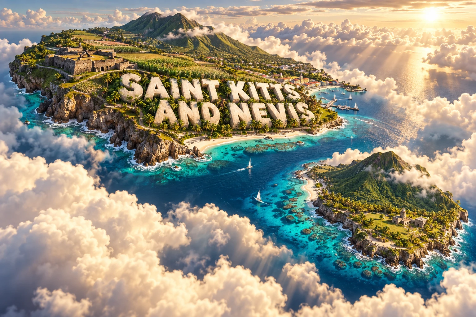
The Saint Kitts and Nevis artwork combines volcanic peaks, tropical beaches, former sugarcane landscapes, fortress architecture, palms and coral reefs. These elements symbolize the islands' volcanic origins, coastal ecosystems, plantation history and Brimstone Hill's colonial architecture. The embedded country name is graphic typography.
The composition compresses two separate islands and environments that do not occur in one exact view. Brimstone Hill stands on Saint Kitts; Nevis Peak dominates Nevis; wetter mountain forest and dry coastal scrub occupy different climate zones; and coral reefs lie underwater around particular shores.
The image is a conceptual artistic composition. The landmarks, wildlife and landscapes are combined for educational visualization and are not shown at their true geographic positions or scale. It is a floating micro-world illustration, not a satellite map, nautical chart or record of present-day sugar cultivation.
12. Interesting Facts About Saint Kitts and Nevis
- It is the smallest sovereign country in the Americas by area and population.
- The official name retains “Saint Christopher,” while “Saint Kitts” is used in everyday national naming.
- A narrow marine channel separates Saint Kitts from Nevis.
- Both main islands were built by volcanoes of the Lesser Antilles arc.
- Mount Liamuiga rises about 1,156 metres above a very small island.
- Nevis Peak is considered potentially active despite having no recorded historical eruption.
- Orographic uplift makes mountain interiors much wetter than some coasts.
- The Southeast Peninsula is notably drier than northern Saint Kitts.
- African green monkeys are introduced rather than native mammals.
- Enslaved Africans built Brimstone Hill Fortress under British direction.
- The fortress became a UNESCO World Heritage property in 1999.
- Sugar production ended commercially in 2005 after centuries of dominance.
- Nevis has its own elected Island Assembly within the federation.
- The Eastern Caribbean dollar is shared with several neighboring states and territories.
- Coral reefs, seagrass beds and coastal wetlands function as connected ecosystems.
13. Short Quiz
-
What geological process built Saint Kitts and Nevis? A. Magma above a subduction zone formed volcanic islands B. A river deposited an enormous delta C. Glaciers piled up coral D. Wind created granite mountains
-
Why are the island interiors generally wetter than some coasts? A. Mountains force moist air upward and cause orographic rainfall B. Coral reefs manufacture rain C. Sugarcane releases clouds D. The highest peaks are below sea level
-
Who performed much of the labor that built Brimstone Hill Fortress? A. Enslaved Africans B. Modern cruise passengers C. Roman soldiers D. Antarctic explorers
-
Which animal was introduced to the islands? A. African green monkey B. Brown pelican C. Hawksbill sea turtle D. Native bat
-
Why is the 3D artwork not a literal map? A. It combines separate islands, habitats and landmarks at symbolic scale B. Every reef is shown at its surveyed depth C. Both peaks occupy the same island D. All modern farms grow sugarcane
Answer key: 1-A, 2-A, 3-A, 4-A, 5-A
14. Related Learning
- Antigua and Barbuda Explained: Limestone islands, reefs and regional connections
- Montserrat Explained: Volcanic eruptions and island transformation
- Saint Lucia Explained: Volcanic peaks, rainforest and coastal ecosystems
- Dominica Explained: Rainfall, rivers and active volcanic landscapes
- Why the Lesser Antilles Form a Volcanic Arc
- How Coral Reefs, Seagrass and Mangroves Work Together
- How Sugar Plantations Reshaped Caribbean Islands
- Why Small Islands Face Disproportionate Hurricane Risk
- How Brimstone Hill Records Colonialism and Enslaved Labor
- Why Some Caribbean Beaches Have Black Sand
15. Sources
- Government of Saint Kitts and Nevis, country profile
- Saint Kitts and Nevis Department of Statistics, census population and area
- UNESCO, Brimstone Hill Fortress National Park
- University of the West Indies Seismic Research Centre, Nevis volcanic profile
- University of the West Indies Seismic Research Centre, Lesser Antilles Volcanic Hazard Atlas
- UN Framework Convention on Climate Change, Saint Kitts and Nevis Third National Communication
- Convention on Biological Diversity, Saint Kitts and Nevis country profile
- FAO, Saint Kitts and Nevis country profile
- Caribbean Development Bank, Caribbean Economic Review and Outlook 2024–2025
- Eastern Caribbean Central Bank, Saint Kitts and Nevis statistics
- World Bank, Saint Kitts and Nevis data
- International Monetary Fund, Saint Kitts and Nevis
- UNESCO, history of Brimstone Hill's inscription
- IUCN Red List, species assessments