

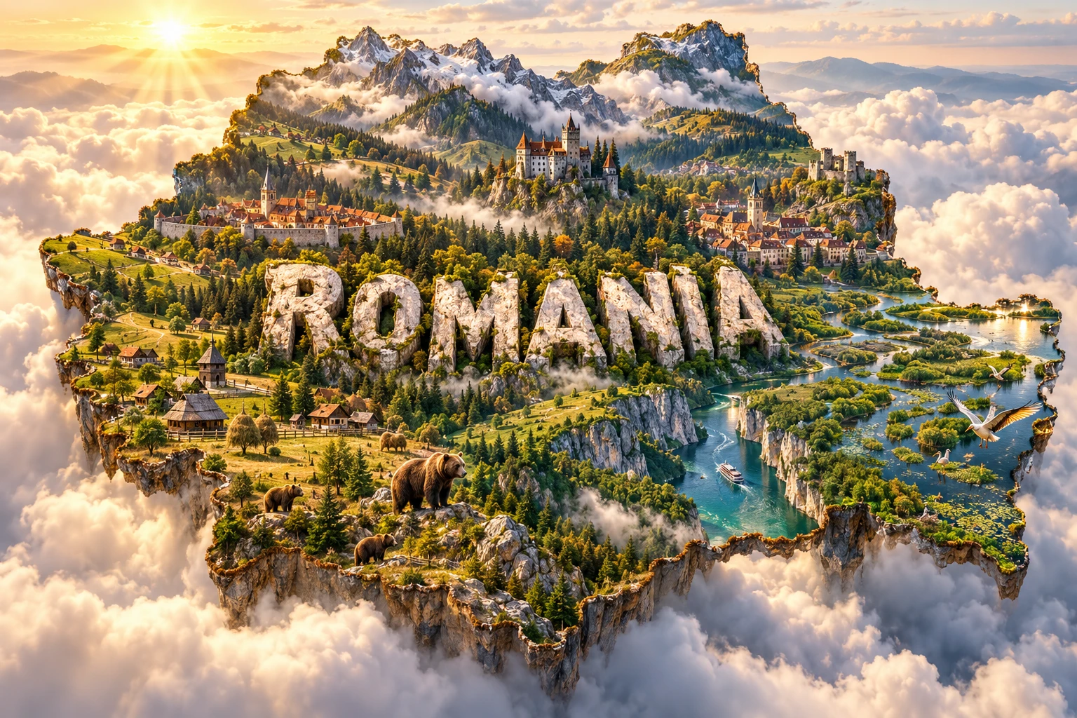
Romania is organized around a remarkable arc of mountains. The Carpathians curve through the center, enclosing the Transylvanian Basin and descending outward through foothills to plains. Along the south, the Danube marks much of the Bulgarian border before spreading into a vast wetland delta at the Black Sea.
This geography helps explain the country's forests, farms, mineral resources, cities and wildlife. Romania supports large populations of brown bears, wolves and lynx in suitable Carpathian habitat, but it also contains steppe-like plains, limestone caves, Black Sea lagoons and reed-filled waterways far from mountain forests.
1. Where Is Romania?
Romania lies in southeastern Europe, with cultural and physical links to Central and Eastern Europe. Ukraine borders it to the north and east, the Republic of Moldova to the east, Bulgaria to the south, Serbia to the southwest and Hungary to the west. The Black Sea forms its southeastern coast.
Bucharest is the capital and largest city. It stands on the Romanian Plain north of the Danube. Other major cities include Cluj-Napoca, Timișoara, Iași, Constanța, Craiova, Brașov, Galați, Oradea and Sibiu.
The Danube enters Romania near Baziaș, passes the Iron Gates gorge and follows much of the southern border. It then turns north and east before dividing into distributaries that reach the Black Sea. Romania shares the delta with Ukraine, although most of the delta lies in Romania.
Historical regions include Transylvania, Wallachia, Moldavia, Dobruja, Banat, Crișana, Maramureș, Bukovina and Oltenia. Their boundaries and meanings vary by period; they are cultural-geographic regions rather than present-day sovereign units.
2. Quick Country Facts
- Official name: Romania
- Capital: Bucharest
- Region: Southeastern Europe
- Area: Approximately 238,397 square kilometres
- Population: About 19.04 million usual residents on 1 January 2025
- Currency: Romanian leu
- Official language: Romanian
- Time zone: Eastern European Time, UTC+2; Eastern European Summer Time, UTC+3
- Highest point: Moldoveanu Peak, 2,544 metres
- Major river: Danube
- Major lakes and lagoons: Razim–Sinoe complex, Lake Snagov and mountain glacial lakes
- Sea: Black Sea
- World Heritage: 11 UNESCO properties—nine cultural and two natural
- Administrative divisions: 41 counties plus the municipality of Bucharest
“Usual resident population” counts people who normally live in Romania, including qualifying foreign residents and excluding emigrants. It differs from the larger administrative count of citizens with a registered Romanian domicile.
3. Geography and Landscape
The Carpathians form an uneven ring through northern, central and western Romania. The Eastern Carpathians include parallel ridges, volcanic ranges and broad depressions. The Southern Carpathians, often called the Transylvanian Alps, contain the highest peaks, including Moldoveanu in the Făgăraș Mountains. The Western Romanian Carpathians, including the Apuseni, are lower but geologically complex and rich in caves and mineral history.
Inside the arc lies the Transylvanian Basin, a hilly region drained mainly by the Mureș and Someș systems. It is not a flat bowl surrounded by one continuous wall; rolling uplands, valleys and passes connect it with neighboring regions.
Outside the mountains, the Subcarpathians form belts of folded hills and depressions. Farther south, the Romanian Plain slopes gently toward the Danube and contains fertile soils developed partly on windblown loess. The Western Plain belongs to the larger Pannonian Basin and supports farming and cities such as Timișoara and Arad.
The Moldavian Plateau lies east of the Carpathians, cut by tributaries of the Siret and Prut. Dobruja, between the lower Danube and Black Sea, includes ancient uplands, dry grasslands, lagoons and the delta. Its Măcin Mountains are low remnants of a very old mountain system.
At the coast, the Danube Delta contains three main distributaries—Chilia, Sulina and Sfântu Gheorghe—together with reed beds, lakes, channels, floating vegetation, dunes and maritime sand bars. South of the delta, the Razim–Sinoe lagoon complex has been partly separated from the sea by barriers and modified by human water works.
4. Why Does Romania Look Like This?
The Carpathians formed through convergence and collision as fragments of crust moved between the European plate and smaller blocks during the Alpine mountain-building era. Sedimentary rocks were folded, faulted and thrust over one another, while older crystalline rocks were uplifted in parts of the Southern and Eastern Carpathians.
As the mountain arc rose, the Transylvanian Basin and foreland basins subsided and accumulated sediment. Compression produced the folded Subcarpathian hills. In the Eastern Carpathians, younger volcanism built a long chain that includes the Călimani, Gurghiu and Harghita ranges. The volcanic system is no longer erupting, but it left craters, mineral springs and geothermal features.
During the Pleistocene, mountain glaciers occupied the highest Southern Carpathians and parts of other ranges. They carved cirques and U-shaped valleys and left small glacial lakes such as Bâlea and Bucura. Ice sheets did not cover Romania as they covered northern Europe.
Rivers eroded the rising mountains and carried gravel, sand and silt to lower basins. Wind later spread fine loess over parts of the plains. These deep, often fertile soils support crops but can erode when bare or intensively cultivated.
The Danube Delta is geologically young and continually changing. River sediment builds channels, levees and wetlands, while Black Sea waves and currents construct or erode coastal barriers. Upstream dams trap much sediment, and engineered channels alter flow. The delta therefore reflects a shifting balance among river discharge, sediment, sea processes and human intervention.
5. Climate
Romania has a temperate continental climate with four seasons. Atlantic, Mediterranean, continental and Black Sea air masses all influence weather, while the Carpathians redirect winds and create regional rain shadows.
Winters are colder in interior basins, northeastern areas and mountains. Summers are generally warm, becoming hotter and drier on the southern and eastern plains. The Black Sea moderates temperatures near the coast but can also supply moisture for fog, cloud and intense storms.
Precipitation is highest on exposed mountain slopes and lower across the plains and Dobruja. Snow remains longest at high elevation. Spring snowmelt and prolonged rain can produce river floods, while convective summer storms bring flash flooding, hail and landslides.
The Carpathian arc creates sharp local contrasts. Moist air rising over slopes cools and produces precipitation; descending air can become warmer and drier. Enclosed depressions sometimes trap cold air and fog during winter inversions.
Climate change is increasing average temperature and the frequency of severe heat. Drought threatens crops, forests, wetlands and water supply, while short intense rainfall can still cause destructive floods. Lower Danube and delta habitats also face altered river flow, Black Sea level change, wildfire and salinity shifts.
6. Wildlife and Ecosystems
Romania's ecosystems include alpine grassland, conifer and beech forest, oak woodland, meadow, steppe-like grassland, rivers, peatlands, caves, coastal lagoons and the Danube Delta. Large forest blocks and mountain corridors make the Carpathians especially important for European wildlife.
Brown bears occur primarily in the Carpathians, not throughout Romania. The country supports one of Europe's largest bear populations outside Russia, but estimates vary with survey method. Conflict around livestock, food waste, roads and settlement requires evidence-based prevention and management; a bear near a village is not simply a tourism symbol.
Grey wolves and Eurasian lynx also use forested mountain landscapes. Red deer, roe deer, wild boar, chamois and wildcats occupy suitable regions. European bison, exterminated from Romania centuries ago, have been reintroduced to free-ranging sites including the Țarcu Mountains and Vânători-Neamț landscape.
The Danube Delta is internationally important for fish and waterbirds. Great white and Dalmatian pelicans nest or feed there, along with cormorants, herons, egrets and many migratory species. Reed beds are habitat, building material and livelihood resource. Sturgeons migrate through the lower Danube, but dams, altered flow, pollution and illegal fishing have damaged their populations.
Dobruja's dry grasslands and rocky habitats support tortoises, reptiles, steppe plants and raptors. Black Sea dolphins occur offshore. The Apuseni and other limestone areas contain cave-adapted bats and invertebrates.
Major pressures include illegal or poorly planned logging, habitat fragmentation, roads, agricultural intensification, invasive species, wetland modification and climate change. Protected areas help, but ecological connections beyond park boundaries remain essential.
7. Famous Landmarks and Natural Features
Romania has 11 UNESCO World Heritage properties as of 2026:
- Danube Delta, a natural property, protects a dynamic river–sea wetland rather than a static wilderness untouched by people.
- Ancient and Primeval Beech Forests of the Carpathians and Other Regions of Europe includes Romanian forest components within a transnational property documenting beech expansion and ecological processes.
- Historic Centre of Sighișoara preserves a small fortified town shaped strongly by Transylvanian Saxon history.
- Villages with Fortified Churches in Transylvania represents rural settlement and defensive church landscapes created by several communities over centuries.
- Churches of Moldavia are known for exterior wall paintings and specific Orthodox artistic traditions.
- Wooden Churches of Maramureș demonstrate regional timber construction, craftsmanship and religious life.
- Dacian Fortresses of the Orăștie Mountains preserve defensive and sacred sites associated with the Dacian kingdom before Roman conquest.
- Frontiers of the Roman Empire—Dacia, inscribed in 2024, is a large serial property of forts, roads and related military infrastructure.
- Brâncuși Monumental Ensemble of Târgu Jiu, also inscribed in 2024, links modern sculpture, landscape and commemoration.
- Hurezi Monastery is an important example of Brâncovenesc architecture and artistic workshops.
- Roșia Montană Mining Landscape records exceptionally long gold-mining history and remains on the List of World Heritage in Danger.
Bran Castle is popularly marketed through the fictional Dracula, but Bram Stoker never visited Romania and the castle's link to Vlad III is limited and debated. Peleș Castle reflects nineteenth-century royal architecture, while Corvin Castle preserves layers of medieval and later construction.
Natural landmarks include the Făgăraș peaks, Iron Gates gorge, Turda Gorge, Scărișoara Ice Cave, Bicaz Gorge, Sfânta Ana volcanic-crater lake and Black Sea coast. These features lie far apart and formed through different processes.
8. People, Languages and Culture
Romanian is the official language. It is a Romance language shaped from Latin and later contact with Slavic, Greek, Turkish, Hungarian, German and other languages. Hungarian is widely used in parts of Transylvania, while Romani has several varieties. German, Ukrainian, Turkish, Tatar, Serbian, Slovak and other languages belong to specific communities.
The population includes Romanians, Hungarians, Roma, Ukrainians, Germans, Turks, Tatars, Serbs, Slovaks, Bulgarians, Jews, Armenians and others. Census identities are self-declared and undercounting can affect minority data, particularly for Roma. Transylvania cannot be reduced to one ethnic group or to vampire stories.
Romania's history includes Dacian societies, Roman conquest, migration and medieval principalities. Wallachia and Moldavia remained politically distinct while often under Ottoman suzerainty; Transylvania followed different Hungarian, Habsburg and Austro-Hungarian histories. Moldavia and Wallachia united in 1859, and independence from the Ottoman Empire was recognized in 1878.
Territorial changes after the First World War created a larger Romanian state with diverse populations. During the Second World War, the Antonescu regime allied with Nazi Germany and Romanian authorities participated in the Holocaust, including mass murder and deportations of Jews and Roma. Soviet influence after the war brought communist rule, repression, industrialization and forced social change.
The violent revolution of December 1989 ended Nicolae Ceaușescu's dictatorship. Romania joined NATO in 2004 and the European Union in 2007. Emigration has created a large diaspora, while return migration and newer immigration influence society.
Regional music, dance, clothing, ceramics, egg decoration, weaving and woodwork vary greatly. The ie, an embroidered blouse, has distinct local patterns rather than one national design. Contemporary Romanian culture includes literature, film, theatre, electronic music, design, science and technology.
9. Food
Romanian food reflects Balkan, Central European, Ottoman, Slavic and local pastoral and farming traditions. Maize, wheat, dairy products, pork, vegetables, beans, fruit and freshwater fish have different regional importance.
Mămăligă is a maize porridge served with cheese, sour cream, stews or fish. Sarmale wrap seasoned fillings in cabbage or vine leaves and belong to a wider family of dishes found across southeastern Europe and Western Asia. Ciorbă refers to many sour soups rather than one recipe.
Mici are grilled seasoned meat rolls. Cozonac is a sweet enriched bread associated with holidays in different forms. In the delta, fish soups and grilled or baked fish reflect local waterways; Transylvanian, Banat, Moldavian and Dobrujan cuisines each combine influences differently.
10. Economy and Major Industries
Services generate most of Romania's economic output. Retail, transport, finance, telecommunications, information technology, health, education and public administration employ large numbers. Bucharest and cities such as Cluj-Napoca, Iași and Timișoara have important software, engineering and business-service sectors.
Manufacturing includes motor vehicles and components, machinery, electrical equipment, chemicals, pharmaceuticals, metals, food, textiles and furniture. Factories are integrated into European supply chains, making transport links, workforce skills and demand in neighboring markets important.
Agriculture uses large areas of plain and plateau. Romania produces maize, wheat, sunflower seed, rapeseed, vegetables, fruit, grapes and livestock. Farm structure ranges from very small household plots to large commercial enterprises. Drought, soil erosion, fragmented irrigation and uneven investment affect productivity.
Energy comes from natural gas, oil, coal, hydropower, nuclear power, wind and solar. Offshore Black Sea gas development is increasing, while decarbonization requires changes in coal regions and electricity networks. The Carpathians and Apuseni also contain salt, metals, timber and mineral-water resources, all requiring environmental safeguards.
EU funding supports infrastructure and investment, but regional gaps, demographic aging, emigration, public-service capacity and rural poverty remain challenges. Tourism draws on cities, mountains, spas, heritage and the delta, yet should be managed to avoid crowding, habitat disturbance and superficial folklore.
11. What the 3D Visual Represents
The Romania artwork combines the Carpathian Mountains, Transylvania-inspired castles, medieval towns, Danube Delta wetlands, forests, brown bears and traditional villages. These elements symbolize mountain geology, layered urban history, forest ecosystems, river–sea processes and regional rural architecture. The embedded “ROMANIA” lettering is a graphic device.
The composition compresses distant places. Transylvanian towns and castles lie inside or near the Carpathian arc, while the Danube Delta is on the far eastern Black Sea coast. Brown bears are primarily associated with suitable Carpathian habitat, not delta reed beds, southern plains or every village. Village architecture differs among regions and communities.
The image is a conceptual artistic composition. The landmarks, wildlife and landscapes are combined for educational visualization and are not shown at their true geographic positions or scale. It is a floating micro-world illustration, not a satellite map, wildlife-range map or reconstruction of one historical region.
12. Interesting Facts About Romania
- The Carpathians form an arc around much of the Transylvanian Basin.
- Romania had about 19.04 million usual residents at the start of 2025.
- Moldoveanu Peak reaches 2,544 metres in the Făgăraș Mountains.
- The Danube forms much of Romania's border with Bulgaria.
- The Danube Delta grows and erodes as river sediment interacts with Black Sea waves and currents.
- Its three main distributaries are Chilia, Sulina and Sfântu Gheorghe.
- Pleistocene glaciers carved high valleys and lake basins in the Southern Carpathians.
- The Eastern Carpathians include a long chain of extinct volcanic mountains.
- Romania has 11 UNESCO World Heritage properties.
- Two properties—the Brâncuși ensemble and Dacia frontier—were inscribed in 2024.
- Roșia Montană remains on UNESCO's List of World Heritage in Danger.
- European bison have been returned to free-ranging Romanian landscapes.
- Brown bears are concentrated mainly in the Carpathians rather than spread evenly nationwide.
- Romanian is a Romance language, unlike most neighboring national languages.
- Bran Castle's association with the fictional Dracula is much stronger in popular culture than in historical evidence.
13. Short Quiz
-
What lies inside much of Romania's Carpathian arc? A. Transylvanian Basin B. Sahara Desert C. Baltic Sea D. Po Valley
-
How does the Danube Delta form and change? A. River sediment interacts with Black Sea waves and currents B. Lava builds a new cone every year C. A glacier blocks the river permanently D. Coral grows across the floodplain
-
Where are brown bears concentrated? A. Suitable Carpathian habitats B. Every Black Sea beach C. Bucharest city center D. Delta channels only
-
Which language family includes Romanian? A. Romance B. Turkic C. Uralic D. Celtic only
-
Why is the 3D visual not a literal map? A. It combines distant regions, landmarks and animals symbolically B. Romania has no mountains C. The delta lies in Transylvania D. Bears inhabit every wetland
Answer key: 1-A, 2-A, 3-A, 4-A, 5-A
14. Related Learning
- Bulgaria Explained: Shared Danube border and Black Sea coast
- Hungary Explained: Carpathian Basin rivers and connected histories
- Moldova Explained: Prut border, Romanian language and Moldavian history
- Ukraine Explained: Shared delta, Carpathians and Black Sea systems
- How the Carpathian Arc Shaped Romania
- How the Danube Built Its Delta
- Why Romania Has So Many Brown Bears
- How Ice-Age Glaciers Shaped the Făgăraș Mountains
- Why Transylvania Is a Basin Surrounded by Mountains
- How Bran Castle Became Linked to Dracula
15. Sources
- Romania National Institute of Statistics, definitive 2021 census results
- Romania National Institute of Statistics, TEMPO population methodology
- Geological Institute of Romania, national geology and mapping
- Geological Institute of Romania, national geological maps
- UNESCO, Romania World Heritage profile
- UNESCO, Danube Delta
- UNESCO, Frontiers of the Roman Empire—Dacia
- UNESCO, Brâncuși Monumental Ensemble of Târgu Jiu
- UNESCO, Roșia Montană Mining Landscape
- Danube Delta Biosphere Reserve Authority
- European Environment Agency, Romania country profile
- European Commission, large carnivores in the EU
- Rewilding Europe, European bison in Romania's Southern Carpathians
- World Bank, Romania overview