

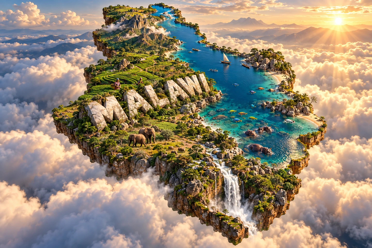
Malawi is a narrow, landlocked country shaped by the East African Rift. Lake Malawi fills a great trough along much of its eastern side, supporting fisheries, transport and one of Earth's most remarkable freshwater fish radiations. Plateaus and isolated mountains rise around it, producing large changes in climate and vegetation over short distances.
The country is not only a lakeshore landscape. Northern grasslands, central plateaus, the Shire Valley, Mount Mulanje, tea-growing highlands, miombo woodland and wetlands each support different communities and wildlife. Geography helps explain both Malawi's extraordinary biodiversity and its dependence on climate-sensitive agriculture.
1. Where Is Malawi?
Malawi lies in southeastern Africa. It borders Tanzania to the north and northeast, Zambia to the west, and Mozambique to the east, south and southwest. The country is landlocked, even though the immense Lake Malawi gives it a shoreline-like eastern edge.
The capital, Lilongwe, is in the central region. Blantyre, in the south, is the principal commercial and industrial city. Other important urban centers include Mzuzu in the north, Zomba near the Shire Highlands, and lakeshore towns such as Mangochi, Salima and Karonga.
Lake Malawi is shared by Malawi, Mozambique and Tanzania. Names and boundary questions around the lake have political histories, so an educational map should follow a recognized cartographic source rather than infer borders from the waterline.
Malawi stretches north to south for roughly 840 kilometers but is much narrower from east to west. This long shape follows the Rift Valley and helps create strong regional differences.
2. Quick Country Facts
- Official name: Republic of Malawi
- Capital: Lilongwe
- Region: Southeastern Africa
- Surface area: approximately 117,726 square kilometers, including inland water
- Population: approximately 22.2 million in 2025, United Nations estimate
- Currency: Malawian kwacha (MWK)
- Official language: English; Chichewa is the national language and widely spoken
- Time zone: Central Africa Time, UTC+2
- Highest point: Sapitwa Peak on Mount Mulanje, approximately 3,002 meters
- Largest lake: Lake Malawi
- Major river: Shire River
- World Heritage properties: three—Lake Malawi National Park, Chongoni Rock-Art Area and Mount Mulanje Cultural Landscape
- Independence: 6 July 1964
Area figures differ because land-only totals exclude Lake Malawi and other inland water. Population estimates also vary by source and reference date.
3. Geography and Landscape
The Great Rift Valley runs through Malawi from north to south. Lake Malawi occupies its deepest and most prominent basin, extending for more than 560 kilometers. The lake accounts for a substantial part of Malawi's total area, although most of its waters are outside Lake Malawi National Park.
Steep escarpments rise west of the lake in places. Farther inland are rolling plateaus generally between about 900 and 1,200 meters. The Nyika Plateau in the north reaches higher elevations and supports montane grassland, while the Viphya highlands carry forest and plantation landscapes.
The central plateau contains Lilongwe and extensive cultivated land. Southward, the Rift broadens around Lake Malombe and the upper Shire River, Lake Malawi's only natural outlet. The Shire flows through wetlands, falls and a lower valley before entering Mozambique and eventually joining the Zambezi.
The Shire Highlands support dense settlement and major cities. Southeast of them, the Mulanje Massif rises abruptly from surrounding plains. Sapitwa Peak is Malawi's highest point. Nearby tea estates occupy humid lower slopes around Mulanje and Thyolo, not the entire mountain.
Malawi also contains Lake Chilwa, a shallow, closed-basin wetland whose area changes dramatically with rainfall and evaporation. Rivers, floodplains, marshes and reservoirs provide habitat and irrigation but also expose settlements to floods.
Miombo woodland once covered large areas of upland Malawi. Today farms, settlements, woodland, plantations and protected areas form a complex mosaic. Sandy Lake Malawi beaches occur in many bays, but rocky shores, reed beds, cliffs and wetlands are equally important.
4. Why Does Malawi Look Like This?
Malawi lies along the southern part of the East African Rift System, where Earth's crust is stretching. Fault blocks have moved relative to one another, producing a long depression bordered by escarpments and uplifted plateaus.
Lake Malawi fills part of this tectonic basin. It is not a simple crack filled overnight: repeated faulting, subsidence, erosion and sediment accumulation shaped the basin over millions of years. Its great depth and long isolation created many ecological opportunities for fish.
The lake's cichlids illustrate adaptive radiation. An ancestral population diversified into many species with different colors, behaviors, habitats and feeding structures. Rocky shores, sandy bottoms, open water and deep zones create separate niches. Sexual selection and geographic separation also helped populations diverge.
Mount Mulanje is an inselberg, an isolated mountain mass rising above lower country. It consists mainly of resistant intrusive rocks formed when magma cooled below the surface. Long erosion removed softer surrounding material and exposed the massif. Cracks, weathering and rivers carved peaks, basins and steep valleys.
The Nyika and other uplands reflect regional uplift and erosion. Rivers descending steep Rift margins can cut narrow valleys and generate hydropower. In the lower Shire Valley, flatter terrain, heat and river sediments create very different conditions.
Soil erosion is intensified where heavy seasonal rain strikes exposed slopes. Farming pressure, deforestation, fire, roads and settlement can accelerate runoff, but geology, soil type and storm intensity also matter. Sediment entering the lake can affect shallow habitats and water quality.
5. Climate
Malawi has a tropical seasonal climate strongly modified by altitude. The main rainy season usually runs from November to April, when moist air and the southward movement of tropical rain systems bring thunderstorms and sustained rain.
The dry season generally lasts from May to October. May through August is cooler, especially at night on plateaus and mountains. September and October are often the hottest months before the rains begin.
The lower Shire Valley is hot and relatively dry. Highland areas such as Nyika, Zomba and Mulanje are cooler and can receive more rain where moist air rises. Lake Malawi moderates temperatures near parts of its shore and contributes local humidity and winds.
Rainfall varies substantially between years. El Niño, La Niña, Indian Ocean conditions and regional atmospheric circulation can contribute to drought or unusually heavy rain. Tropical cyclones that move inland from the Mozambique Channel can bring devastating floods and landslides even though Malawi has no ocean coast.
Climate shocks directly affect maize harvests, hydropower, roads, water supply and food prices. Climate change is increasing heat and may intensify rainfall extremes and dry spells. The outcome in any district also depends on watershed condition, farming practices, infrastructure and early warning.
6. Wildlife and Ecosystems
Lake Malawi is famous for cichlid fish. Scientific totals change as species are described and classifications revised, but the lake holds hundreds of cichlid species, most found nowhere else. Colorful rock-associated species called mbuna occupy particular shallow, rocky habitats; not every cichlid is an mbuna.
The lake also contains catfish, sardine-like usipa, chambo and other fish important to diets and livelihoods. Overfishing, fine-mesh nets, habitat change, pollution, invasive species risk and warming threaten parts of the ecosystem. Lake Malawi National Park protects only a small southern portion, so lake-wide cooperation matters.
Miombo woodland supports antelopes, monkeys, small mammals and birds. Elephants occur in protected landscapes including Liwonde, Majete and Nkhotakota, where conservation and translocation programs have rebuilt some populations. They are localized, not common across ordinary farmland.
Hippos and crocodiles inhabit suitable lakes, rivers and wetlands, especially around the Shire system. They are dangerous wild animals and should not be imagined beside every recreational beach. Liwonde's floodplain also supports waterbirds, antelope and predators.
Nyika's high grasslands and forest patches support roan antelope, eland, zebra, orchids and many birds. Mount Mulanje has endemic and range-restricted plants and animals, including the threatened Mulanje cedar, but plantations and tea fields are distinct from native montane ecosystems.
Habitat loss, charcoal production, illegal hunting, invasive species, agricultural expansion and climate stress remain pressures. Conservation initiatives increasingly link protected areas with community livelihoods, but outcomes differ among sites.
7. Famous Landmarks and Natural Features
Lake Malawi National Park, centered around Cape Maclear and nearby islands, became a World Heritage property in 1984. Its rocky shore fish communities provide an exceptional example of evolution. The property covers only about 94 square kilometers, including roughly seven square kilometers of water, rather than the whole lake.
The Chongoni Rock-Art Area protects 127 recorded sites among granite hills in central Malawi. Paintings made by BaTwa hunter-gatherers and later Chewa farming communities preserve long cultural histories. Some imagery remains connected to living initiation and Nyau traditions, so the shelters are not simply abandoned galleries.
UNESCO inscribed the Mount Mulanje Cultural Landscape in 2025. It recognizes an associative sacred landscape maintained through the beliefs and practices of Yao, Mang'anja and Lhomwe custodial communities. The designation concerns relationships among people, spirits, waters, caves, forests and the mountain—not only scenic geology.
Nyika Plateau is Malawi's largest high-elevation landscape, characterized by rolling grassland, valleys and forest patches. The Nyika–Vwaza landscape joined Malawi's Tentative List in 2025 but is not yet an inscribed World Heritage property.
Liwonde National Park follows the Shire River and protects floodplain, woodland and aquatic habitat. Majete and Nkhotakota are other major wildlife reserves. Their animal populations reflect active management and, in some cases, reintroductions.
Lake Chilwa, Zomba Plateau, the Viphya highlands, the Lower Shire wetlands and tea-growing landscapes of Thyolo and Mulanje are also geographically and culturally important.
8. People, Languages and Culture
Malawi includes Chewa, Lomwe, Yao, Tumbuka, Sena, Tonga, Ngoni, Nkhonde and other communities. Identities, languages and settlement patterns overlap, and no single group represents the entire country.
English is the official language. Chichewa is the national language and a major lingua franca, particularly in central and southern regions. Chitumbuka is widely used in the north, while Chiyao, Chilomwe, Chisena and other languages remain important. Urban multilingualism is common.
Music and dance vary by community and occasion. Gule Wamkulu, associated with the Chewa Nyau brotherhood in Malawi, Zambia and Mozambique, uses masked performance in ritual and social contexts and is recognized by UNESCO as intangible heritage. Its sacred meanings should not be reduced to entertainment or treated as a national custom practiced by everyone.
Basketry, pottery, woodcarving, mat weaving and textile traditions are regionally diverse. Storytelling, proverbs, churches, mosques and community ceremonies contribute to cultural life. Football and contemporary gospel, hip-hop and popular music have large audiences.
States linked to the Maravi confederacy developed in the region centuries ago. Yao trading networks and nineteenth-century Ngoni migrations reshaped communities before British colonial rule. Britain established the Central African Protectorate, later called Nyasaland, and then incorporated it into the Federation of Rhodesia and Nyasaland from 1953 to 1963.
Malawi became independent in 1964. Hastings Banda led an increasingly authoritarian one-party state until a 1993 referendum approved multiparty politics. Elections have followed, including a court-ordered presidential rerun in 2020. Historical achievements and political stability should be discussed alongside repression, inequality and continuing institutional challenges.
9. Food
Nsima, a thick porridge usually made from maize flour, is the principal staple for many households. It is eaten with ndiwo, a broad category of relishes made from leafy vegetables, beans, fish, eggs or meat.
Fish from Lake Malawi and other waters are important. Chambo refers to several tilapiine cichlids valued as food, while usipa are small lake fish commonly dried. Fish availability, species and price differ by region and season.
Rice is important around lakeshore and irrigated areas. Cassava is a major staple in parts of the north and along the lake; kondowole is a firm cassava preparation associated especially with northern Malawi. Sweet potatoes, sorghum, groundnuts, pigeon peas and beans add dietary variety.
Tea is grown commercially in the southern highlands, while sugarcane, coffee and macadamia also enter local and export markets. Thobwa is a nonalcoholic fermented grain drink in common forms, although preparation varies.
10. Economy and Major Industries
Agriculture remains Malawi's main livelihood and provides most merchandise export earnings. Smallholders grow maize, groundnuts, pulses, cassava, rice and horticultural crops. Estates and smallholders produce tobacco, tea, sugarcane, coffee and macadamia nuts.
Tobacco still supplies roughly half of merchandise export value, exposing the economy to changing demand, prices and regulation. Diversification efforts focus on agro-processing, legumes, nuts, tea, sugar, mining and services. Replacing a dominant export takes infrastructure, markets and investment rather than a simple crop switch.
Manufacturing includes food and beverage processing, tobacco preparation, textiles, cement and consumer goods. Services include trade, transport, telecommunications, banking, government, education and health. Fisheries support food security and local commerce but face pressure from overharvesting and environmental change.
Hydropower on the Shire River supplies much electricity, making generation vulnerable to low flows, sediment and extreme weather. Solar and other sources are expanding, while limited and unreliable power remains a constraint.
The World Bank reported real GDP growth of 1.9 percent in 2025, below population growth, alongside very high inflation and foreign-exchange shortages. Agriculture employs a majority of workers and remains heavily rain-fed. Stronger productivity, export diversity, infrastructure, fiscal stability and climate resilience are central development needs.
11. What the 3D Visual Represents
The Malawi artwork combines Lake Malawi, mountainous highlands, tea plantations, sandy beaches, colorful cichlid fish, elephants and hippos. These elements symbolize the Rift Valley, freshwater evolution, southern agriculture and selected protected wildlife landscapes.
The lake is the organizing feature, but its depiction compresses a basin hundreds of kilometers long. Highlands may evoke Nyika, Zomba and Mulanje, which have different geology, height and vegetation. Tea plantations refer mainly to suitable southern highland districts.
Colorful fish represent Lake Malawi's diverse cichlids, especially rocky-shore mbuna. Elephants represent particular reserves such as Liwonde, Majete and Nkhotakota. Hippos represent suitable river, wetland and lakeshore habitat, not every beach. White “MALAWI” lettering identifies the country.
The image is a conceptual artistic composition. The lake, highlands, tea estates, beaches, fish, elephants and hippos are combined for educational visualization and are not shown at their true geographic positions or scale. It is an illustrative floating micro-world, not a satellite map.
12. Interesting Facts About Malawi
- Malawi is landlocked but has an extensive shoreline on Lake Malawi.
- The country's long, narrow form follows part of the East African Rift System.
- Lake Malawi drains through the Shire River into the Zambezi system.
- The lake contains hundreds of cichlid species, most found nowhere else.
- Mbuna are primarily rock-associated cichlids, not a name for every lake fish.
- Lake Malawi National Park protects only a small fraction of the whole lake.
- Sapitwa Peak on Mount Mulanje rises to about 3,002 meters.
- Mount Mulanje is a huge inselberg exposed by long erosion.
- Malawi gained a third World Heritage property when Mount Mulanje Cultural Landscape was inscribed in 2025.
- Chongoni contains 127 recorded rock-art sites.
- Chichewa is Malawi's national language, while English is official.
- Lake Chilwa expands and contracts because it is shallow and has no outlet to the sea.
- Tropical cyclones can cause serious inland damage despite Malawi having no ocean coast.
- Maize is the dominant food crop, while tobacco remains the leading merchandise export.
- Tea estates concentrate in the humid southern highlands around Thyolo and Mulanje.
13. Short Quiz
-
What geological system shaped Lake Malawi's basin? A. East African Rift System B. Mid-Atlantic Ridge C. Himalayan collision zone D. Pacific Ring of Fire
-
What is Lake Malawi's only natural outlet? A. Shire River B. Nile River C. Limpopo River D. Congo River
-
Why are Lake Malawi's cichlids scientifically important? A. They show adaptive radiation and speciation B. They migrate across oceans each year C. They are all one identical species D. They build coral reefs
-
Which landmark became a World Heritage property in 2025? A. Mount Mulanje Cultural Landscape B. Lake Chilwa Wetland C. Nyika National Park D. Zomba Plateau
-
What is nsima? A. A thick staple porridge B. A mountain antelope C. A rock painting pigment D. A tea variety
Answer key: 1-A, 2-A, 3-A, 4-A, 5-A
14. Related Learning
Suggested internal-link opportunities:
- Mozambique Explained: Indian Ocean Coast and Rift Landscapes
- Tanzania Explained: Rift Valleys, Volcanoes and Wildlife
- Zambia Explained: Plateaus, Rivers and Victoria Falls
- How the East African Rift Created Lake Malawi
- Why Lake Malawi Has So Many Cichlid Fish
- How Adaptive Radiation Creates New Species
- Why Mount Mulanje Rises Above the Plains
- How the Shire River Connects Lake Malawi to the Zambezi
- Why Malawi's Climate Changes with Altitude
- How Tea Grows in Malawi's Southern Highlands
15. Sources
- United Nations Data — Malawi , for 2025 population, area, capital and currency
- World Bank — Malawi Overview , for current population context, agriculture, poverty and economic conditions
- World Bank — Malawi Economic Monitor 2026 , for 2025 growth, exports, inflation and structural constraints
- UNESCO World Heritage Centre — Malawi , for the three World Heritage properties and 2025 Tentative List
- UNESCO — Lake Malawi National Park , for Rift geology, park boundaries, fish diversity and evolutionary importance
- UNESCO — Mount Mulanje Cultural Landscape , for the 2025 inscription, sacred landscape and custodial communities
- UNESCO — Chongoni Rock-Art Area , for its 127 sites, painting traditions and living associations
- FAO — Malawi at a Glance , for agriculture, employment and climate vulnerability
- Malawi National Agriculture Policy 2024 , for maize, tobacco, tea, smallholders and diversification
- FAO — Malawi Country Brief , for current rainfall, harvest and food-price context
- UNESCO Intangible Cultural Heritage — Gule Wamkulu , for Chewa Nyau performance and its cross-border context
- Encyclopaedia Britannica — Malawi , for stable geographic, climatic, historical and cultural background