

Luxembourg is one of Europe's smallest sovereign countries, but its landscape and society are unusually varied. Wooded Ardennes plateaus occupy the north, sandstone cliffs and farmland cross the center, former iron-mining country lies in the south, and vineyards follow the Moselle in the east.
The capital sits above deep river valleys and preserves the remains of a fortress once contested by Europe's major powers. Modern Luxembourg is equally shaped by multilingualism, migration, commuters from three neighboring countries, European institutions and an international financial and services economy.
1. Where Is Luxembourg?
Luxembourg is a landlocked country in Western Europe. Belgium borders it to the west and north, Germany to the east, and France to the south. Its official name, the Grand Duchy of Luxembourg, reflects the fact that it is the world's only remaining sovereign grand duchy.
The capital, Luxembourg City, stands in the south-central part of the country where the Alzette and Pétrusse rivers have cut steep valleys into a sandstone plateau. It is the largest city and the main governmental, financial and international center.
Esch-sur-Alzette, in the former iron-and-steel region near France, is the second-largest city. Differdange and Dudelange also grew with industry. Ettelbruck and Diekirch serve the central-northern region, while Vianden, Echternach and Grevenmacher are smaller historic centers.
Luxembourg has no coast but connects closely to its neighbors through roads, railways and daily commuting. Belgium, Luxembourg and the Netherlands form Benelux, while all three belong to the European Union.
2. Quick Country Facts
- Official name: Grand Duchy of Luxembourg
- Capital: Luxembourg City
- Region: Western Europe
- Area: 2,586 square kilometers
- Population: approximately 691,000 at the end of 2025, STATEC estimate
- Currency: euro (EUR)
- Languages: Luxembourgish is the national language; French is the legislative language; Luxembourgish, French and German are used in administration and justice
- Time zone: Central European Time, UTC+1; daylight saving time UTC+2
- Highest point: Kneiff, near Wilwerdange, approximately 560 meters
- Major rivers: Moselle, Sûre, Our, Alzette and Pétrusse
- World Heritage properties: one cultural property
- Political form: constitutional monarchy and parliamentary democracy
Population should be dated because migration makes it change quickly. Sources may differ by reference date and method.
3. Geography and Landscape
Luxembourg has two broad natural regions. The northern Oesling covers roughly one-third of the country and forms part of the Ardennes. It is a dissected upland of forested ridges, high plateaus and narrow river valleys. Kneiff, the country's highest point, lies near its northern edge.
The central and southern Gutland, meaning “good country,” covers the remaining two-thirds. It includes rolling farmland, broad valleys, wooded sandstone plateaus, limestone and marl. More fertile soils supported denser settlement and agriculture.
East of the capital, Luxembourg Sandstone creates cliffs, ravines and freestanding rock forms. This is especially visible in the Mullerthal region. The rocks are not mountains on the scale of the Alps; they are eroded edges and blocks of a sedimentary plateau.
In the southeast, the Moselle Valley forms part of the German border. Vineyards grow on favorable slopes above the river, while villages and towns occupy terraces and valley floors. The Moselle joins the Rhine in Germany and connects Luxembourg to a larger European drainage network.
The Minett, or Land of the Red Rocks, lies in the south. Iron-bearing rock and ore deposits underpinned mining and steelmaking. Former quarries, industrial sites and spoil ground now form a partly reclaimed landscape with towns, new habitats and cultural facilities.
The Sûre crosses the country from west to east and joins the Moselle. Its tributaries include the Alzette, while the Our forms part of the German border. The Upper Sûre reservoir is an important source of drinking water as well as an artificial lake.
4. Why Does Luxembourg Look Like This?
The contrast between Oesling and Gutland begins with geology. Oesling exposes ancient Paleozoic rocks that were folded and compressed during the Variscan mountain-building event hundreds of millions of years ago. Those mountains have long since eroded, leaving resistant slate and quartz-rich ridges.
Rivers cut into the uplifted Ardennes surface, producing the Oesling's steep-sided, winding valleys. Thin, acidic soils and broken terrain favor forest and pasture more than broad arable fields. The coldest and wettest conditions occur on the northern plateau.
Gutland is underlain mainly by younger Mesozoic sedimentary rocks, including sandstone, limestone and marl. Rock layers erode at different rates: resistant sandstone forms plateaus and cliffs, while softer marl creates lower, broader farmland. Cracks in Luxembourg Sandstone widen through water, frost and root action, making the Mullerthal's narrow passages and blocky formations.
In the south, iron accumulated in Jurassic marine sediments. Luxembourg's reddish minette ore was not exceptionally rich, but large deposits combined with railways, coal from nearby regions and industrial investment to drive steel production from the nineteenth century.
Luxembourg City's setting is another result of erosion. The Alzette and Pétrusse carved around a resistant sandstone promontory, leaving high ground protected by steep slopes. Builders turned this natural defensive position into an elaborate fortress with walls, bastions and underground casemates.
Along the Moselle, river incision created slopes with suitable exposure and drainage for vines. Bedrock, soil, slope direction and a relatively sheltered valley climate influence wine growing; vineyards are agricultural landscapes, not natural vegetation.
5. Climate
Luxembourg has a temperate oceanic climate influenced by Atlantic weather systems. Rain falls throughout the year, summers are generally mild to warm, and winters are cool. Conditions can change rapidly as air masses arrive from the ocean or continental Europe.
The Oesling is usually cooler, wetter and windier because it is higher and more exposed. Snow and frost tend to occur more often there. Lower parts of Gutland and the Moselle Valley are somewhat warmer and more sheltered, helping agriculture and grape growing.
Seasons are variable. Winter alternates between frost, rain and brief snow, while summer can bring wet spells, heatwaves or drought.
Rain feeds rivers and reservoirs, yet intense storms can raise water rapidly in narrow valleys. Flooding affected several Luxembourg river basins in July 2021. Flood risk depends on storm tracks, saturated soils, valley development and drainage, not simply annual rainfall totals.
Climate change is increasing average temperatures and the likelihood of severe heat while altering drought, heavy-rain and ecosystem risks. Forests face heat, water stress, storms, pests and disease. Vine growers may see changes in ripening dates and grape suitability, but effects differ by site and year.
6. Wildlife and Ecosystems
Forests cover about one-third of Luxembourg and include beech, oak, hornbeam, spruce, Douglas fir and other trees. Some stands are semi-natural; others were planted and managed for timber. Old trees and dead wood provide nesting, roosting and feeding habitat.
Native mammals include roe deer, red deer, wild boar, red foxes, badgers, European wildcats, pine martens and several bats. Beavers have returned to waterways. These animals occupy suitable habitats and are not evenly distributed across the small country.
Forest and farmland birds include black woodpeckers, kites and owls. Black storks use quiet woodland near streams, while kingfishers depend on clean water and suitable banks. The Moselle and other waterways support fish, aquatic insects and waterbirds.
Wet meadows, calcareous grasslands, orchards, rocky slopes and abandoned mines add habitat diversity. Former iron-ore workings in the Minett now shelter rare plants, insects and bats; industrial disturbance can create valuable secondary habitat without erasing the environmental costs of mining.
Luxembourg reports about 29 percent of its territory under nature protection through national and European designations. Natura 2000 sites conserve habitats for species including Bechstein's bat, marsh fritillary butterflies and freshwater mussels.
Major pressures include habitat fragmentation, road traffic, intensive land use, stream modification, pollution, invasive species and climate change. Because Luxembourg is highly urbanized and crossed by transport routes, ecological corridors connecting forests, rivers and grasslands are particularly important.
7. Famous Landmarks and Natural Features
The Old Quarters and Fortifications of Luxembourg City form the country's only UNESCO World Heritage property. A castle was established on the Bock promontory in the tenth century, and successive Burgundian, Habsburg, Spanish, French, Austrian and Prussian authorities expanded the defenses.
The fortress became known as the “Gibraltar of the North.” Most defenses were dismantled after the 1867 Treaty of London, but gates, walls and casemates survive. The Alzette and Pétrusse valleys created its natural defense.
The Adolphe Bridge, completed in the early twentieth century, spans the Pétrusse Valley and represents Luxembourg City's expansion beyond the old fortress. Other bridges at different levels connect plateau districts with valley neighborhoods, making topography visible in the urban plan.
Vianden Castle rises above the Our Valley. Its medieval structures developed over centuries on older foundations and were extensively restored in modern times. It illustrates feudal and dynastic history, but it is not a separate World Heritage property.
Echternach is associated with a monastery founded by Willibrord in the seventh century. Its dancing procession is recognized by UNESCO as intangible cultural heritage. The town also provides access to the sandstone ravines and forests of the Mullerthal.
The Moselle Valley is important for vineyards, river settlements and the village of Schengen, where the 1985 agreement associated with removing internal European border checks was signed. In the south, restored industrial sites around Esch-Belval and nature reserves in former mining areas explain the steel era and later economic transition.
8. People, Languages and Culture
Luxembourg is highly multilingual. Luxembourgish, a West Germanic language closely related to Moselle Franconian varieties, is the national language. French is the language of legislation. Luxembourgish, French and German may be used in administrative and judicial matters, while actual language choice depends on school, workplace, media and social setting.
English is prominent in finance, technology and international institutions. Portuguese is widely spoken because people of Portuguese origin form a major community. Italian and many other European and global languages are also part of daily life.
At the start of 2025, foreign nationals made up 47 percent of residents, according to STATEC. That figure does not include the very large number of people who commute daily from France, Belgium and Germany. Nationality, home language and cultural identity overlap in complex ways; “Luxembourger” cannot be reduced to ancestry or one language.
Music, theater and literature operate in several languages. Brass bands and village associations coexist with international institutions. Éimaischen, held after Easter, is known for ceramic bird whistles called Péckvillercher. Participation varies.
The medieval county became a duchy in 1354. Its fortress and strategic position brought rule by successive European dynasties and powers. The Congress of Vienna created a grand duchy in 1815 in personal union with the Dutch crown; the 1839 settlement fixed much of today's territory. The country gained greater autonomy and established its current dynasty in the nineteenth century.
Germany occupied Luxembourg during both world wars. Nazi rule during the Second World War imposed annexation policies, conscription and repression; Jewish residents were persecuted and deported. After liberation, Luxembourg abandoned permanent neutrality, helped found Benelux, NATO and the European communities that developed into the EU. Several EU institutions are based in Luxembourg City.
9. Food
Luxembourg's food reflects rural farming, river valleys and exchange with French, German and Belgian cuisines. Contemporary restaurants and households also reflect Portuguese, Italian and wider international influences.
Judd mat Gaardebounen combines smoked pork collar with broad beans and is often described as a national dish. Bouneschlupp is a green-bean soup that may include potatoes, leeks and bacon. Recipes vary by cook and season.
Gromperekichelcher are crisp potato cakes commonly sold at fairs and markets. Rye or mixed-grain breads, sausages, ham, freshwater fish, cheese and pastries also appear in regional cooking.
The Moselle produces mainly white and sparkling wines, including wines from Riesling, Auxerrois and Pinot varieties. Terroir and production standards differ along the valley, so “Luxembourg wine” is a category rather than one flavor.
10. Economy and Major Industries
Luxembourg changed from a rural economy into an iron-and-steel center, then developed one of the world's most internationally connected service economies. Steel remains important through companies and expertise, even though most domestic ore mines have closed.
Finance and insurance are central, including banking, investment funds, insurance and related legal, accounting and technology services. The sector generates high output but also exposes the economy to international financial conditions. High GDP per person is affected by profits and by the many cross-border workers who help produce output but are not counted as residents in the population denominator; it is not a measure of every household's income.
Other activities include technology, logistics, satellite businesses, professional services, construction, health care and European institutions. Manufacturing includes steel, chemicals, machinery, automotive components and food products.
Agriculture occupies a visible share of land but a small share of economic output. Farms produce milk, cattle, cereals and other crops, while viticulture concentrates along the Moselle.
Nearly half of employment was held by incoming cross-border workers in 2023, according to the European Commission. This daily movement binds Luxembourg to neighboring housing and transport systems while adding congestion and infrastructure pressure.
The World Bank recorded 0.6 percent real GDP growth in 2025. Current challenges include housing affordability, labor and skill supply, traffic, land pressure, pension costs, energy transition and diversification. Financial success does not remove social or environmental tradeoffs.
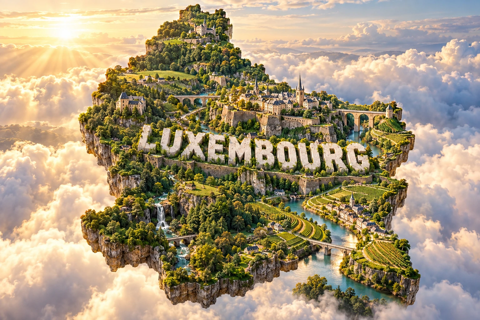
11. What the 3D Visual Represents
The Luxembourg artwork combines Luxembourg City-style fortifications, stone bridges, green valleys, forests, castles and Moselle vineyards. These elements represent how geology, defense, rivers, agriculture and settlement interact within a small territory.
The fortress walls and casemates evoke the capital's Bock promontory and UNESCO-listed old quarters. Bridges symbolize the engineering needed to cross the Alzette and Pétrusse valleys. Castles refer broadly to sites such as Vianden rather than placing one exact building in the capital.
Forests and valleys represent both the Ardennes-like Oesling and the sandstone landscapes of Gutland. Vineyards refer specifically to the Moselle Valley, not the entire country. White “LUXEMBOURG” lettering identifies the subject.
The image is a conceptual artistic composition. The fortifications, bridges, valleys, forests, castles and vineyards are combined for educational visualization and are not shown at their true geographic positions or scale. It is an illustrative floating micro-world, not a satellite map.
12. Interesting Facts About Luxembourg
- Luxembourg is a landlocked country bordered by Belgium, Germany and France.
- At 2,586 square kilometers, it is one of Europe's smallest sovereign states.
- It is the world's only remaining sovereign grand duchy.
- Oesling belongs to the Ardennes, while Gutland has younger sandstone, limestone and marl landscapes.
- Kneiff, the highest point, is only about 560 meters above sea level.
- Luxembourg City occupies a sandstone promontory cut by the Alzette and Pétrusse rivers.
- The capital's old quarters and fortifications are Luxembourg's only World Heritage property.
- Most of the fortress was dismantled after the Treaty of London in 1867.
- Luxembourgish is the national language, French the legislative language, and three languages are used administratively.
- Foreign nationals made up 47 percent of residents at the start of 2025.
- Large numbers of workers commute from France, Belgium and Germany each day.
- Minette iron ore helped build a major steel industry in the nineteenth and twentieth centuries.
- The Moselle Valley is the country's principal wine-growing region.
- The Schengen Agreement takes its name from the Luxembourg village where it was signed in 1985.
- Luxembourg was a founding member of the European communities that evolved into the European Union.
13. Short Quiz
-
Which three countries border Luxembourg? A. Belgium, Germany and France B. France, Spain and Italy C. Germany, Austria and Switzerland D. Belgium, Netherlands and Denmark
-
What are Luxembourg's two main natural regions? A. Oesling and Gutland B. Alps and Jura C. Flanders and Wallonia D. Taiga and tundra
-
Why was Luxembourg City easy to fortify? A. Rivers cut steep valleys around a sandstone promontory B. Glaciers surrounded it with permanent ice C. It stood on an offshore island D. Active volcanoes formed a crater wall
-
Where are Luxembourg's main vineyards? A. Moselle Valley B. Oesling plateau C. Pétrusse gorge D. Minett mines
-
Which is Luxembourg's national language? A. Luxembourgish B. Dutch C. English D. Spanish
Answer key: 1-A, 2-A, 3-A, 4-A, 5-A
14. Related Learning
Suggested internal-link opportunities:
- Belgium Explained: Lowlands, Languages and European Crossroads
- Germany Explained: Rivers, Uplands, Industry and Culture
- France Explained: Landscapes, Regions and Cultural History
- How Rivers and Sandstone Shaped Luxembourg City
- Why Luxembourg Built Such a Powerful Fortress
- How Minette Iron Ore Transformed Luxembourg
- Why Luxembourg Uses Three Administrative Languages
- How Cross-Border Commuting Shapes Luxembourg
- Why Vineyards Grow Along the Moselle River
- How the Schengen Agreement Changed European Borders
15. Sources
- STATEC — Luxembourg's Demography in Figures 2025 , for population, migration and nationality data
- STATEC — Luxembourg in Figures 2025 , for current territory, society, labor and economic statistics
- World Bank — Luxembourg Data , for 2025 population and economic indicators and forest area
- Government of Luxembourg — Geography of the Grand Duchy , for area, Oesling, Gutland, geology, highest point and regional landscapes
- Government of Luxembourg — Languages , for national, legislative, administrative and commonly spoken languages
- Government of Luxembourg — Natura 2000 , for protected land, habitats and selected species
- Government of Luxembourg — Forests , for forest ecosystems and management
- UNESCO World Heritage Centre — Luxembourg , for the country's single World Heritage property
- UNESCO — City of Luxembourg: Old Quarters and Fortifications , for fortress history, topography and surviving structures
- UNESCO Intangible Cultural Heritage — Dancing Procession of Echternach , for the procession's living heritage status
- European Commission — Luxembourg Country Report , for finance, productivity, cross-border labor and structural challenges
- European Commission — Economic Forecast for Luxembourg , for 2025 growth and current economic context
- Encyclopaedia Britannica — Luxembourg , for stable geography, climate, history and economic background