

Iceland is a North Atlantic island where an oceanic plate boundary rises above sea level. The North American and Eurasian plates pull apart beneath the country, while unusually strong magma production builds new crust. Glaciers, rivers, wind and waves then reshape that volcanic foundation into ice caps, lava fields, waterfalls, fjords and black-sand plains.
This interaction of fire, ice, ocean and atmosphere makes Iceland an exceptional place to study Earth processes. It also shapes settlement, energy, farming and transport. Most people live near the coast, especially around Reykjavík, while the high interior remains sparsely inhabited.
1. Where Is Iceland?
Iceland is an island country in the North Atlantic Ocean between Greenland and Norway, northwest of the United Kingdom. It lies just south of and partly across the Arctic Circle: the small island of Grímsey is crossed by the circle, while the main island is mostly to its south.
Iceland has no land borders. Its nearest neighbors across the sea include Greenland, the Faroe Islands, Norway and the United Kingdom. The country includes the main island and many smaller islands, among them the Westman Islands, or Vestmannaeyjar.
Reykjavík is the capital and largest city. Together with nearby municipalities, the capital region contains well over half the national population. Akureyri is the largest urban center in the north, while other coastal towns support fishing, services, transport and regional communities.
2. Quick Country Facts
- Official name: Iceland
- Capital: Reykjavík
- Region: Northern Europe and the North Atlantic
- Area: Approximately 103,000 square kilometers
- Population: 394,324 on 1 January 2026, according to Statistics Iceland
- Currency: Icelandic króna (ISK)
- Official language: Icelandic; Icelandic Sign Language also has legal recognition
- Time zone: Greenwich Mean Time, UTC+0, throughout the year
- Highest point: Hvannadalshnúkur, approximately 2,110 meters, on the Öræfajökull volcanic massif
- Longest river: Þjórsá, approximately 230 kilometers
- Largest natural lake by surface area: Þingvallavatn
- Largest ice cap: Vatnajökull
Iceland does not change its clocks for daylight-saving time. Day length nevertheless varies dramatically, from very short winter days to near-continuous summer light in the north.
3. Geography and Landscape
Iceland is built mostly of basaltic volcanic rock. Active volcanic zones cross the island from the southwest toward the northeast, with an additional western zone and several connecting seismic areas. Fissure swarms, central volcanoes, lava shields, crater rows and geothermal fields mark these zones.
The central highlands contain deserts of lava, sand and gravel, mountain ridges and ice caps. Sparse vegetation, cold conditions, rivers and difficult terrain limit permanent settlement. Roads and tracks through the interior are highly seasonal and can be closed by snow, flooding or fragile ground conditions.
Glaciers cover a substantial portion of the country. Vatnajökull is the largest, with numerous outlet glaciers flowing from its ice cap. Langjökull, Hofsjökull, Mýrdalsjökull and Drangajökull are other major ice masses. Glacial rivers carry enormous quantities of sediment toward broad outwash plains called sandar.
Iceland's coast is deeply indented in the west, north and east, where fjords cut into older volcanic plateaus. The south coast is generally straighter and bordered by extensive black-sand plains built by glacial rivers, volcanic sediment and waves. Sea cliffs and offshore stacks support major bird colonies.
Waterfalls are common because rivers descend across resistant lava layers, cliffs and uplifted terrain. Gullfoss drops through a canyon; Dettifoss carries powerful glacial river flow; and Seljalandsfoss and Skógafoss fall from former sea cliffs in the south. Each has a different geological and hydrological setting.
4. Why Does Iceland Look Like This?
The Mid-Atlantic Ridge separates the North American and Eurasian plates. Most of this ridge lies beneath the ocean, but in Iceland it rises above sea level because it overlaps a mantle plume—a region of unusually hot, upwelling mantle that supplies abundant magma. Plate spreading and magma together continually add volcanic rock.
The plates move apart at roughly two centimeters per year, averaged over geological time. Spreading is not smooth everywhere. Strain builds, earthquakes occur and magma intrudes into fissures. Eruptions may happen along long cracks rather than from a single cone, producing extensive basalt lava fields.
Volcano–ice interactions create distinctive hazards and landforms. Magma erupting beneath glaciers can melt large volumes of ice, causing sudden floods called jökulhlaups. Subglacial eruptions also build flat-topped mountains and ridges from fragmented volcanic glass and lava constrained by ice.
Repeated Ice Age glaciation carved valleys and fjords and stripped away rock. Modern glaciers continue to erode mountains and deposit moraines and sediment. When glaciers retreat, newly exposed terrain, lagoons and unstable slopes continue to evolve.
Black beaches form largely from dark basaltic volcanic material broken down by eruptions, rivers and waves. Their sediment can be moved rapidly by powerful North Atlantic surf. They are not all made from the same eruption, and sneaker waves make some shorelines extremely dangerous.
Geothermal systems occur where groundwater circulates through hot rock. Heated water and steam rise along fractures, producing hot springs, fumaroles, mud pools and geysers. Iceland's famous Geysir gave the English language the word “geyser,” though it is not continuously active.
5. Climate
Iceland has a cool maritime climate that is milder than its latitude might suggest. A branch of the North Atlantic Current carries ocean heat toward the south and west coasts, while the surrounding ocean limits temperature extremes.
Weather changes rapidly as North Atlantic low-pressure systems pass. Coastal winters are often windy, wet and near freezing rather than continuously bitterly cold. Summers are cool. The high interior and northern valleys can be much colder, and elevation increases snowfall and shortens the growing season.
Southern slopes and glaciers receive heavy precipitation from moist ocean air. Northern and inner regions can be drier because mountains and ice caps remove moisture. Wind is a major climatic force, affecting travel, soil erosion, buildings and livestock.
The aurora borealis occurs when charged particles from the Sun interact with Earth's upper atmosphere and magnetic field. It can be seen only when skies are dark and sufficiently clear, generally from late summer through early spring. It is not visible throughout bright summer nights and cannot be guaranteed on any particular evening.
Climate change is warming Iceland, shrinking glaciers and changing runoff. Retreating ice initially increases meltwater in some rivers, but long-term storage declines. Thaw, vegetation change, ocean warming and acidification affect terrestrial and marine ecosystems. Local land movement complicates sea-level change because the crust rebounds as glacier mass is lost.
6. Wildlife and Ecosystems
Iceland's isolation, young geology and repeated glaciation limited the number of native land species. The Arctic fox is its only native terrestrial mammal. Foxes occur in different habitats and color forms, but their density varies with food, seabird colonies, human activity and region.
Reindeer were introduced in the 18th century and now live wild mainly in eastern Iceland. American mink escaped from fur farms and became invasive. Polar bears occasionally arrive on sea ice from Greenland but have never established a breeding population.
Iceland is globally important for seabirds, waterfowl and migratory waders. Puffins breed in burrows at selected coastal colonies and islands; they do not cover every cliff. Fulmars, guillemots, razorbills, gannets, eiders and Arctic terns use different nesting habitats. Many seabird populations are declining as food webs, climate and breeding success change.
Marine waters support cod, haddock, capelin and other fish as well as seals and several whale species. Productive ocean currents and shelf waters underpin both ecosystems and fisheries. Sustainable management is complex because stocks cross boundaries and respond to fishing and ocean change.
Much of the lowland vegetation is heath, grassland, wetland or moss-rich lava. Iceland once had more birch woodland than today, though the extent before settlement remains debated. Clearing, grazing, volcanic ash, wind and cold contributed to severe soil erosion. Restoration and afforestation projects now protect soil and expand woodland, while some introduced trees and plants require ecological care.
Icelandic horses are a domestic breed descended from animals brought by settlers; they are not native wildlife. Their isolation helped preserve distinctive characteristics and gaits. Strict import rules protect animal health, and horses exported from Iceland cannot return.
7. Famous Landmarks and Natural Features
Þingvellir National Park combines geology and history. Fissures and cliffs mark an active rift zone, while the Alþingi assembly met here beginning around AD 930. The visible gap is a broad zone of deformation, not a neat line where someone can touch two entire continents at once.
Vatnajökull National Park protects an enormous system of ice caps, volcanoes, rivers, sandur plains and canyons. UNESCO recognizes the exceptional interaction of an exposed rift, mantle plume, atmosphere and ice. Subglacial volcanoes can trigger jökulhlaups, while glacier retreat reveals rapidly changing terrain.
Surtsey emerged south of Iceland during eruptions from 1963 to 1967. Access is tightly restricted so scientists can study how organisms colonize new land with minimal human disturbance. Waves have already eroded much of the original island.
Jökulsárlón is a glacial lagoon that expanded as Breiðamerkurjökull retreated. Icebergs calve into the lagoon and may drift toward the sea. It is a striking landscape but also direct evidence of glacier change.
The Mývatn–Krafla region includes a shallow lake rich in birdlife, lava formations, craters and active geothermal systems. Snæfellsjökull, the Westfjords, Reynisfjara, Gullfoss and the Westman Islands represent other distinct regions rather than a single connected route.
8. People, Languages and Culture
Most settlement began after Norse and Celtic people arrived in the late ninth century, although monks may have visited earlier. The Alþingi was established around 930. Iceland later came under Norwegian and then Danish rule, gained sovereignty in union with Denmark in 1918 and became a republic in 1944.
Icelandic is a North Germanic language. Its written tradition preserves medieval works including sagas and eddic poetry, but the modern language is living and changing rather than a museum form of Old Norse. Icelandic Sign Language is used by the Deaf community, and immigration has added Polish, English, Lithuanian and many other languages.
Contemporary Iceland is highly urban. Literature, music, visual art, film, design and digital culture flourish alongside rural farming and fishing communities. Swimming pools are important social spaces because geothermal heat makes year-round public bathing practical in many towns.
Traditional turf buildings used thick earth walls and roofs to conserve scarce timber and provide insulation. They were practical adaptations that changed over time, not a universal architectural style. Folklore involving hidden people, trolls and seasonal figures remains culturally familiar, but belief and practice vary among individuals.
9. Food
Icelandic food reflects a northern island environment. Fish such as cod and haddock remain important, served fresh, dried, salted or smoked. Lamb comes from sheep grazing in lowland and upland pastures, while dairy products include skyr, a cultured product high in protein.
Rye bread may be baked slowly using geothermal ground heat in suitable areas, but this is a regional technique rather than the way all Icelandic bread is made. Potatoes, greenhouse-grown vegetables and imported ingredients broaden modern diets. Geothermal energy heats many greenhouses but does not replace the need for food imports.
Historical preservation methods included drying, fermenting and smoking because fresh food storage was difficult. Foods such as hákarl have cultural and historical context but are not everyday meals for most residents. Reykjavík and other towns now have diverse restaurants shaped by migration and global exchange.
10. Economy and Major Industries
Iceland has a small, high-income economy. Services provide most jobs and output, including public services, commerce, finance, technology, transport and tourism. Tourism grew rapidly because of the country's landscapes and air connections, bringing income but also pressure on housing, infrastructure and fragile sites.
Fisheries and seafood processing remain central to exports and many coastal communities. Quota management is intended to keep catches within scientific limits, but allocation, ecosystem effects and changing fish distributions remain subjects of debate.
Hydropower and geothermal plants generate almost all domestic electricity, while geothermal heat warms most buildings. Renewable electricity supports energy-intensive aluminum smelting and emerging industries. Renewable does not mean impact-free: dams alter rivers and landscapes, geothermal fields can decline or release gases, and transmission infrastructure affects land.
Other activities include software, biotechnology, creative industries, construction, agriculture and data services. Iceland imports many goods and remains exposed to exchange-rate shifts, global tourism trends, fish-stock changes and volcanic disruption. Planning for eruptions, earthquakes, storms and climate change is therefore economically important.
11. What the 3D Visual Represents
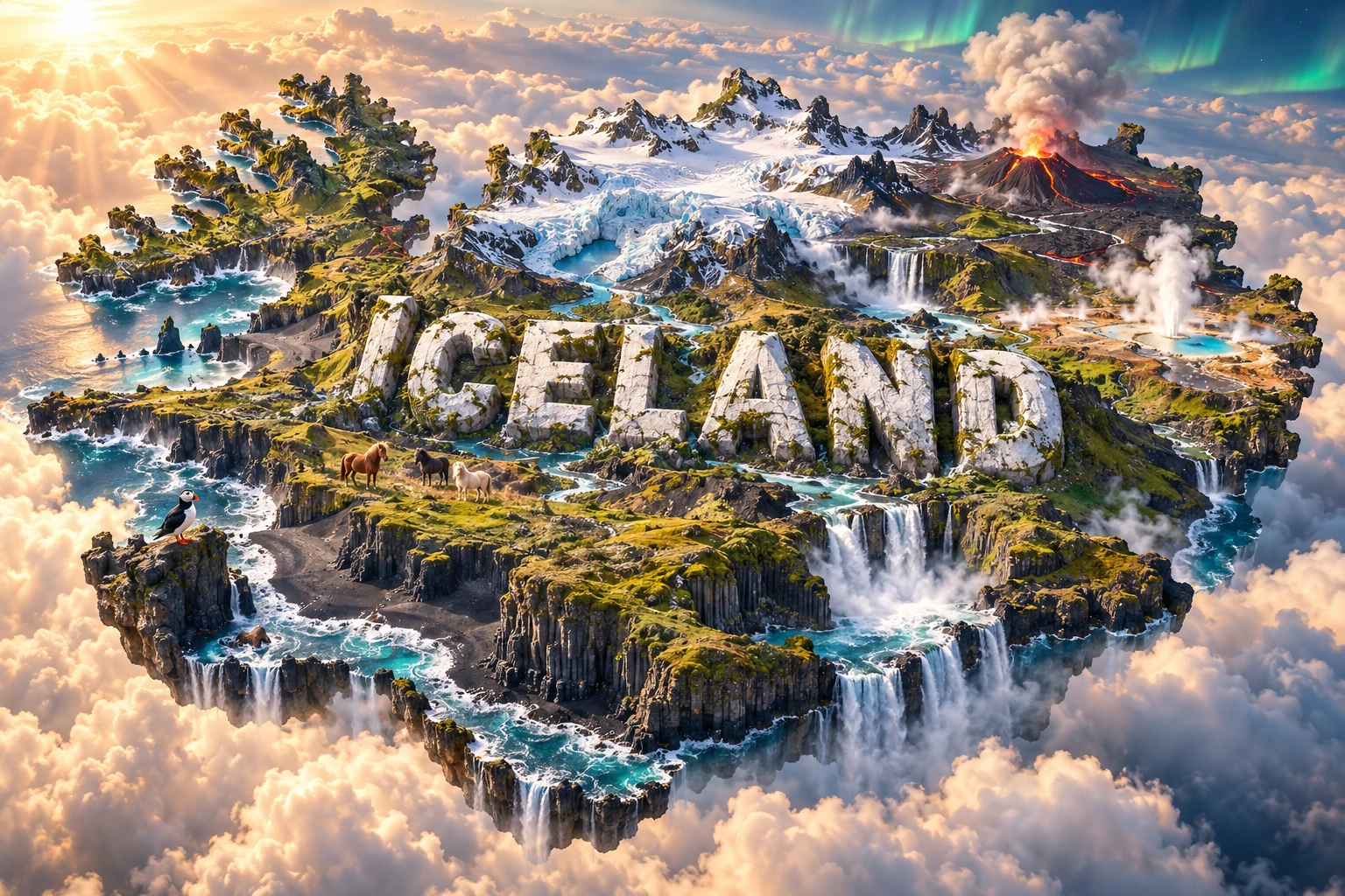
The Iceland artwork combines volcanoes, glaciers, black-sand beaches, waterfalls, geothermal springs, moss-covered lava fields, Icelandic horses and the northern lights. Monumental “ICELAND” lettering and floating terrain compress these features into one dramatic scene.
In reality, these elements occur under different conditions and in different places. Auroras require dark, clear skies and solar activity; active geothermal fields are localized; black beaches reflect particular sediment systems; horses are domestic animals; and glaciers cover certain highland regions rather than the entire island.
The image is a conceptual artistic composition. The landmarks, animals, atmospheric effects and landscapes are combined for educational visualization and are not shown at their true geographic positions or scale. It is not a satellite map, hazard map or promise of simultaneous natural events.
12. Interesting Facts About Iceland
- Iceland sits on an exposed section of the Mid-Atlantic Ridge.
- A mantle plume adds extra magma, helping raise the ridge above sea level.
- The North American and Eurasian plates move apart at roughly two centimeters per year on average.
- Vatnajökull is Europe's largest ice cap by volume.
- Subglacial eruptions can release sudden floods called jökulhlaups.
- Surtsey formed in eruptions between 1963 and 1967 and is protected as a scientific laboratory.
- The Arctic fox is Iceland's only native land mammal.
- Reindeer, mink, mice and Icelandic horses were introduced by people.
- Iceland stays on UTC+0 all year and does not use seasonal clock changes.
- Ocean circulation makes Iceland milder than many places at similar latitude.
- The Alþingi assembly began meeting at Þingvellir around AD 930.
- Geothermal energy heats most Icelandic buildings, while hydropower and geothermal plants dominate electricity generation.
- Black-sand beaches are largely made from eroded basaltic volcanic material.
- Auroras are a space-weather phenomenon and require darkness to be visible.
- As glaciers melt, parts of Iceland's crust rise because the weight of ice is reduced.
13. Short Quiz
-
Why does Iceland have unusually intense volcanic activity? A. It lies where a spreading ridge overlaps a mantle plume B. It is entirely made of coral C. Its rivers ignite underground coal D. Daily tides melt the crust
-
What is a jökulhlaup? A. A seabird colony B. A sudden glacial outburst flood C. A type of northern light D. A traditional boat
-
Which land mammal is native to Iceland? A. Reindeer B. Icelandic horse C. Arctic fox D. American mink
-
Why is Surtsey scientifically important? A. It is an old continental mountain B. It allows protected study of colonization on a new volcanic island C. It contains Iceland's capital D. It is the largest glacier
-
How should the 3D artwork be interpreted? A. As an exact hazard map B. As a satellite photograph C. As a conceptual combination of features from different places and conditions D. As one real lava field
Answer key: 1-A, 2-B, 3-C, 4-B, 5-C.
14. Related Learning
Suggested internal-link topics:
- Norway Explained: Fjords, Mountains and Arctic Landscapes
- Greenland Explained: Ice Sheet, Fjords and Arctic Climate
- United Kingdom Explained: Islands, Geology and Regional Landscapes
- Why Does Iceland Have So Many Volcanoes?
- How Volcanoes and Glaciers Interact in Iceland
- Why Iceland Has Black-Sand Beaches
- How Geothermal Energy Heats Iceland
- Why Iceland's Glaciers Are Shrinking
- How Surtsey Became a Natural Laboratory
- What Causes the Northern Lights?
15. Sources
- Statistics Iceland — population on 1 January 2026
- Icelandic Meteorological Office — Icelandic climate
- Icelandic Meteorological Office — volcanic hazard and geology
- Icelandic Meteorological Office — climate report
- Icelandic Institute of Natural History — mammals
- Icelandic Institute of Natural History — birds
- Icelandic Institute of Natural History — seabird colonies
- National Energy Authority — Icelandic energy data
- UNESCO — Iceland's World Heritage properties
- UNESCO — Vatnajökull National Park
- UNESCO — Þingvellir National Park
- UNESCO — Surtsey