

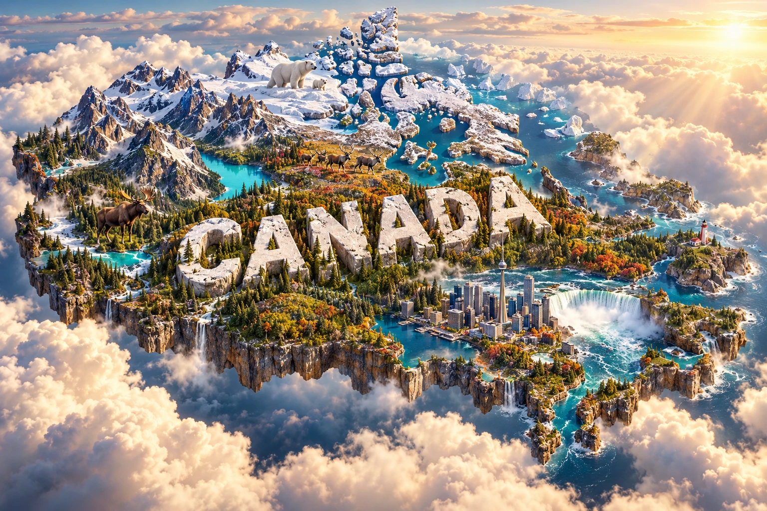
Canada is the world's second-largest country by total area, stretching from the Atlantic to the Pacific and north into the Arctic. Its landscape contains very old exposed bedrock, enormous forests, prairies, western mountains, Arctic tundra, glaciers and more lake area than any other country.
Much of this geography was transformed by ice. Continental glaciers scraped and polished the Canadian Shield, shifted sediment, reorganized rivers and left countless lake basins. In the west, much younger tectonic processes raised the Rocky and Coast mountains. These landscapes shape where people live, how goods move and which ecosystems occur.
1. Where Is Canada?
Canada occupies the northern part of North America. It shares a long land boundary with the United States along the south and between Alaska and northwestern Canada. The Atlantic Ocean lies to the east, the Pacific to the west and the Arctic Ocean to the north. Greenland, an autonomous territory within the Kingdom of Denmark, lies to the northeast; Canada and Greenland share a short land boundary on tiny Tartupaluk, or Hans Island.
Canada is a federation of ten provinces and three territories. Ottawa, in Ontario, is the national capital. Toronto is the largest city, while Montréal, Vancouver, Calgary, Edmonton, Québec City, Winnipeg and Halifax are other important urban centers.
Much of the population lives relatively close to the southern border, where climates are generally milder and transport links are denser. Northern Canada occupies an immense area but has a much smaller, widely dispersed population.
2. Quick Country Facts
- Official name: Canada
- Capital: Ottawa
- Continent: North America
- Provinces and territories: 10 provinces and 3 territories
- Total area: Approximately 9,984,670 square kilometers
- Population: Approximately 41.5 million in early 2026; estimates change quarterly
- Currency: Canadian dollar (CAD)
- Official languages: English and French at the federal level
- Indigenous languages: More than 70 distinct Indigenous languages are reported by Statistics Canada, belonging to multiple language families
- Time zones: Six standard time zones, with regional differences in daylight-saving practice
- Highest point: Mount Logan, Yukon, 5,959 meters
- Longest river entirely in Canada: Mackenzie River system
- Largest lake entirely in Canada: Great Bear Lake
3. Geography and Landscape
Canada's central geological core is the Canadian Shield, a vast area of ancient crystalline rock curving around Hudson Bay. It covers much of eastern and central Canada and appears as rolling rock, thin soils, forests, wetlands and innumerable lakes. South and west of the Shield are the Interior Plains, where sedimentary rocks and glacial deposits support prairie grasslands, farming and energy resources.
Western Canada is mountainous. The Rocky Mountains rise along the Alberta–British Columbia region, while the Coast Mountains stand nearer the Pacific. Between and beyond them are plateaus, valleys and additional ranges. Glaciers and icefields still occupy high elevations, feeding rivers and turquoise lakes colored by fine suspended rock flour.
Eastern Canada includes the Appalachian region of Atlantic Canada and eastern Québec. These old, eroded mountains continue southwest into the United States. The Great Lakes–St. Lawrence Lowlands contain fertile land, major waterways and Canada's densest concentration of people and industry. Niagara Falls lies on the Niagara River between lakes Erie and Ontario, directly on the international boundary.
The north includes tundra, permafrost, the Arctic Archipelago and long coastlines cut by channels and fjords. Hudson Bay reaches deep into the continent. Canada has coastlines on three oceans, but measuring their total length depends on map scale and treatment of islands, so simple “longest coastline” figures require caution.
4. Why Does Canada Look Like This?
Canada combines extremely old continental crust with younger mountain belts. Parts of the Canadian Shield contain rocks billions of years old. Repeated mountain-building, volcanic activity and erosion assembled and reshaped this core long before today's landscape existed. Over immense spans of time, erosion wore the Shield into lower relief.
Western mountains formed as tectonic plates and fragments of crust interacted along the edge of North America. Compression folded, faulted and uplifted sedimentary rocks into the Canadian Rockies. Farther west, subduction and other plate-boundary processes contributed to the Coast Mountains, volcanoes and continuing earthquake activity along the Pacific margin.
The recent ice ages had an especially visible effect. The Laurentide Ice Sheet covered most of Canada east of the Rockies, while the Cordilleran Ice Sheet covered much of the west. Moving ice removed weathered material, deepened valleys and scoured depressions. Retreating ice left till, eskers, moraines and huge meltwater lakes. Modern lakes fill many of the resulting basins, while glacial deposits created or improved soils in some lowlands.
Niagara Falls developed after the last major glaciation reorganized Great Lakes drainage. Water flowing from Lake Erie toward Lake Ontario crossed the resistant Niagara Escarpment. The falls have migrated upstream as erosion removes softer rock beneath a harder cap layer.
5. Climate
Canada's size produces major climatic contrasts. The far north has polar and tundra climates with long, very cold winters and short summers. Much of the interior has a continental climate: winters are cold, summers can be warm or hot, and annual temperature ranges are large. Southern coastal British Columbia has milder, wetter winters because of Pacific influence.
Mountains force moist Pacific air upward, producing heavy precipitation on windward slopes and much drier conditions in some interior rain shadows. Atlantic Canada is strongly influenced by the ocean and passing storms. Southern Ontario and Québec experience four distinct seasons, with the Great Lakes locally affecting snowfall and temperature.
Permafrost underlies extensive northern areas. Canada is warming rapidly, especially in the north, affecting sea ice, glaciers, permafrost, wildfire patterns, ecosystems and communities. Climate does not change uniformly: coastal, prairie, mountain, forest and Arctic regions face different combinations of hazards.
6. Wildlife and Ecosystems
Canada contains Arctic tundra, boreal forest, temperate rainforest, prairie, mountain ecosystems, wetlands, freshwater and three marine regions. Boreal forest stretches in a broad band from Yukon and British Columbia to Newfoundland and Labrador and covers more than half the country.
Polar bears occur in Arctic and subarctic coastal regions where sea ice provides access to seals; they do not live throughout Canada. Wapusk National Park on Hudson Bay protects a major maternity-denning area. Caribou occupy tundra, boreal forest and some mountain habitats, but different populations behave differently. Barren-ground caribou may migrate in large herds, whereas woodland caribou often live in smaller groups and depend on extensive mature forest.
Moose live in forested habitats across much of Canada, while bighorn sheep and mountain goats are western mountain species. Grizzly bears occur mainly in western and northern regions; black bears have a wider forest distribution. Atlantic and Pacific waters support whales, seals, seabirds and commercially important fish.
Habitat fragmentation, climate change, invasive species, pollution and overharvesting threaten some populations. Indigenous Guardians programs, national and provincial parks, territorial and Indigenous protected areas, wildlife refuges and private conservation lands all contribute to stewardship. Protected boundaries alone cannot conserve migratory animals, so connected habitats are important.
7. Famous Landmarks and Natural Features
Canadian Rocky Mountain Parks
Banff, Jasper, Kootenay and Yoho national parks join three British Columbia provincial parks in a UNESCO World Heritage property. Folded and uplifted rocks, glaciers, icefields, canyons, caves and lakes demonstrate mountain and glacial processes. The region also contains the Burgess Shale, famous for exceptionally preserved fossils of early marine animals.
Niagara Falls
Niagara Falls is a group of waterfalls on the Canada–United States boundary. Horseshoe Falls spans the border but lies mostly in Canada. The falls are important for geology, tourism and hydroelectric power; they are far from the Rockies depicted beside them in the artwork.
Gros Morne National Park
Gros Morne in Newfoundland and Labrador displays rocks from deep within Earth and former ocean crust that were pushed upward during continental collision. Its mountains and fjords were later strongly modified by glaciers.
L'Anse aux Meadows
At the northern tip of Newfoundland, this archaeological site preserves remains of an eleventh-century Norse settlement. It is the earliest confirmed European presence in North America and includes turf-building foundations and evidence of ironworking and ship repair.
Old Québec
The historic district of Québec City reflects the development of a fortified colonial city associated with New France. Its importance belongs within a wider history that also includes Indigenous nations, British conquest and the continuing French-speaking identity of Québec.
Head-Smashed-In Buffalo Jump
This cultural landscape in Alberta preserves evidence of Plains peoples' highly organized communal bison hunting over thousands of years. It demonstrates detailed ecological knowledge and social cooperation, not a simple or isolated hunting technique.
8. People, Languages and Culture
Canada's population includes First Nations, Inuit and Métis peoples, descendants of French and British settlers, and communities formed through migration from every inhabited continent. Indigenous peoples are distinct nations and cultures, not one group. Their rights, treaties, languages and relationships with the Crown differ by place.
English and French are Canada's official federal languages. French is the majority language in Québec and is used in communities elsewhere, including Acadian regions. New Brunswick is officially bilingual. Cree languages, Inuktut varieties, Ojibwe, Dene languages and many other Indigenous languages remain culturally vital, although colonial policies severely disrupted transmission of many of them.
Canadian culture varies by region and community. Inuit printmaking, Québec music, First Nations carving, Métis fiddle traditions, Caribbean carnivals, South Asian festivals and contemporary literature and film are examples within a much wider cultural field. Ice hockey and lacrosse are official national sports, but participation and interest extend to many other sports.
Modern Canada emerged through French and British colonization, Confederation in 1867 and later territorial expansion. This history included treaties as well as displacement, the reserve system and residential schools imposed on Indigenous peoples. Educational accounts should recognize both constitutional development and the continuing work of truth, reconciliation and Indigenous self-determination.
9. Food
Canadian food traditions reflect Indigenous knowledge, regional ingredients and migration. Indigenous foods vary enormously and include preparations based on salmon, Arctic char, game, maize, beans, berries and wild rice, depending on the nation and ecosystem.
Québec is associated with dishes such as tourtière and poutine. Atlantic communities have strong seafood traditions, while prairie agriculture supplies grains, pulses and livestock. Maple syrup is produced mainly in eastern Canada, especially Québec; it is not harvested equally across the country. Chinese Canadian, Ukrainian Canadian, Caribbean, South Asian and many other communities have created regional food traditions that are now part of Canadian life.
10. Economy and Major Industries
Canada has a diversified, service-led economy. Finance, real estate, retail, health care, education, transportation, professional services and public administration employ large numbers of people. Toronto, Montréal, Vancouver, Calgary and other cities are major economic centers.
Natural-resource industries remain important and are strongly regional. Canada produces oil and natural gas, hydroelectricity, minerals, timber and agricultural goods. Farming includes wheat, canola and pulses on the Prairies, dairy production in central and eastern regions, and varied horticulture. Fisheries operate on Atlantic, Pacific and freshwater systems under changing ecological conditions.
Manufacturing includes vehicles, aerospace products, food, machinery, chemicals, wood products and metals. Technology and creative industries are also significant. Resource development can generate income and employment while creating environmental effects and disputes over land, water and Indigenous rights.
11. What the 3D Visual Represents
The artwork combines the Rocky Mountains, turquoise glacial lakes, Niagara Falls, boreal forest, Atlantic and Pacific coastlines and a Toronto-inspired skyline. Polar bears, moose and caribou symbolize wildlife from different Canadian ecosystems.
These elements are widely separated. Niagara is in southern Ontario, the Rockies are in Alberta and British Columbia, and Toronto lies beside Lake Ontario. Polar bears belong to northern coastal and sea-ice environments, while the depicted mountain lakes are thousands of kilometers from many polar-bear habitats. Moose and caribou ranges overlap in some regions but differ by habitat and population.
The image is a conceptual artistic composition. The landmarks, wildlife and landscapes are combined for educational visualization and are not shown at their true geographic positions or scale. It is not a satellite map.
12. Interesting Facts About Canada
- Canada borders the Atlantic, Pacific and Arctic oceans.
- It has ten provinces and three territories.
- Most Canadians live in the southern part of the country.
- The Canadian Shield contains some of Earth's oldest exposed rocks.
- Ice sheets helped create Canada's enormous number of lake basins.
- Mount Logan is Canada's highest point at 5,959 meters.
- Great Bear Lake is the largest lake located entirely within Canada.
- The Great Lakes are shared with the United States.
- Boreal forest covers more than half of Canada.
- Polar bears occur mainly in northern sea-ice and coastal ecosystems, not nationwide.
- Niagara Falls has migrated upstream through erosion.
- English and French are official languages at the federal level.
- Canada contains more than 70 distinct Indigenous languages.
- L'Anse aux Meadows preserves evidence of an eleventh-century Norse settlement.
- The Burgess Shale contains exceptionally preserved fossils of early marine animals.
13. Short Quiz
-
Which landscape forms Canada's ancient geological core? A. Canadian Shield B. Great Rift Valley C. Amazon Basin D. Deccan Plateau
-
Why does Canada have so many lakes? A. Every lake is artificial B. Ice sheets scoured basins and disrupted drainage C. Tides filled the entire interior D. Volcanoes formed all of them
-
What is Canada's highest point? A. Mount Robson B. Mount Logan C. Ben Nevis D. Denali
-
Where do Canadian polar bears primarily occur? A. Southern prairie farms B. Northern coastal and sea-ice regions C. Every province equally D. Only near Niagara Falls
-
What does the 3D visual show? A. Exact locations and scale B. A satellite photograph C. A conceptual combination of distant features D. Only landscapes near Toronto
Answer Key
- A
- B
- B
- B
- C
14. Related Learning
- United States Explained: Geography, Landscapes and Wildlife
- How Ice Sheets Created Canada's Lakes
- Why the Canadian Shield Has So Many Exposed Rocks
- How the Canadian Rocky Mountains Formed
- How Niagara Falls Formed and Why It Moves
- Why Canada's Population Is Concentrated in the South
- How Boreal Forests Store Carbon
- Why Polar Bears Depend on Sea Ice
- Indigenous Languages of Canada
- How the Great Lakes Shape Climate
15. Sources
- Statistics Canada — Population estimates — current quarterly population estimates
- Government of Canada — Official-language statistics — English and French language context
- Natural Resources Canada — Canadian Shield granite bedrock — Shield geology
- Geological Survey of Canada — Quaternary geology of the Canadian Shield — glacial landscape history
- Parks Canada — Boreal forests — distribution and ecology
- Parks Canada — Southern mountain caribou — caribou habitat and conservation
- Parks Canada — Wapusk National Park climate and ecology — polar-bear, caribou and peatland context
- UNESCO World Heritage Centre — Canada — heritage properties
- UNESCO — Canadian Rocky Mountain Parks — mountain, glacial and fossil significance
- UNESCO — L'Anse aux Meadows — Norse archaeological evidence
- Statistics Canada — GDP by industry, 2025 — current industry context