

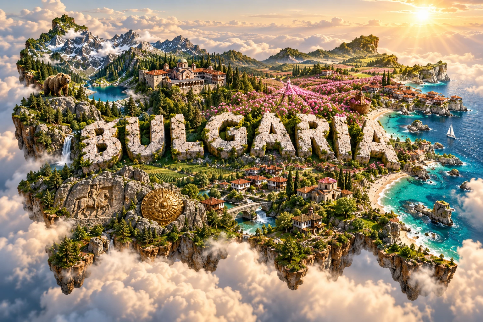
Bulgaria is a southeastern European country where mountain chains divide fertile plains, river basins and the Black Sea coast. The Danube forms much of its northern boundary, the Balkan Mountains cross its center, and the Rila–Rhodope highlands contain the peninsula's tallest summit.
Its landscape has supported Thracian communities, Roman cities, medieval Bulgarian states, Ottoman-era towns and modern industries. Rose fields and monasteries are recognizable symbols, but they represent particular regions within a much more varied country.
1. Where Is Bulgaria?
Bulgaria lies in southeastern Europe on the eastern Balkan Peninsula. Romania borders it to the north, largely along the Danube. Serbia and North Macedonia lie to the west, Greece and Türkiye to the south, and the Black Sea to the east.
Sofia, in a high basin near the western border, is the capital and largest city. Plovdiv is a major cultural and industrial center in the Upper Thracian Plain. Varna and Burgas are the main Black Sea ports, while Ruse stands on the Danube. Other important cities include Stara Zagora, Pleven, Veliko Tarnovo, Blagoevgrad and Shumen.
Bulgaria is both a Balkan and Black Sea country. Its position has long connected central Europe, the Mediterranean, Anatolia and the Eurasian steppe.
2. Quick Country Facts
- Official name: Republic of Bulgaria
- Capital: Sofia
- Region: Southeastern Europe; Balkan Peninsula
- Area: 110,996.8 square kilometers in Bulgaria's official 2025 territorial balance
- Population: 6,423,207 on 31 December 2025
- Currency: Euro (EUR), adopted on 1 January 2026
- Official language: Bulgarian
- Writing system: Cyrillic alphabet
- Time zone: Eastern European Time (UTC+2), with summer time at UTC+3
- Highest point: Musala, 2,925 meters, in the Rila Mountains
- Longest major river on the border: Danube
- Major internal river: Maritsa
- Coast: Black Sea
Bulgaria's population is shrinking and ageing. Official totals should be dated because births, deaths and migration change the figure each year.
3. Geography and Landscape
The Danubian Plain occupies much of northern Bulgaria. It is a rolling region of fertile soils cut by south-to-north tributaries of the Danube. Loess—fine windblown sediment deposited during colder periods—covers substantial areas and supports farming, though it can erode easily.
The Balkan Mountains, or Stara Planina, extend west to east across the country. Although not Bulgaria's highest range, they form an important climatic and drainage divide. The name “Balkan” entered wider geographic use from this range.
South of the Balkans lie a series of basins and the Sredna Gora hills. The famous Rose Valley follows sheltered valleys between Stara Planina and Sredna Gora around Kazanlak and Karlovo. Farther south, the broad Upper Thracian Plain follows the Maritsa River toward Türkiye and the Aegean Sea.
Southwestern Bulgaria contains the Rila and Pirin mountains. Musala in Rila is the highest point in Bulgaria and the entire Balkan Peninsula. Glacial landforms, high lakes, conifer forests and alpine meadows distinguish these ranges. The Rhodope Mountains spread across the south toward Greece, with rounded forested ridges, gorges and caves.
The Black Sea coast includes cliffs, sandy beaches, dunes, lagoons and estuaries. Cape Kaliakra projects from the northern coast, while the Burgas lake complex in the south provides important wetland habitat.
4. Why Does Bulgaria Look Like This?
Bulgaria lies within the Alpine–Himalayan mountain belt, shaped by the long collision and rearrangement of the African, Adriatic and Eurasian tectonic regions. Compression folded and faulted rocks, while later uplift and erosion created today's separate ranges and basins.
Rila, Pirin and parts of the Rhodopes expose ancient crystalline rocks that have been uplifted and reshaped. During Ice Age cold periods, small mountain glaciers carved cirques, sharpened ridges and excavated basins now occupied by lakes. Bulgaria has no modern glaciers.
The Sofia, Kazanlak and Upper Thracian basins formed where faulting lowered blocks between uplands. Rivers filled these depressions with sediment, creating flatter land for cities, roads and agriculture. Fault activity also helps explain Bulgaria's mineral and thermal springs and continuing earthquake risk.
Limestone dissolves slowly in slightly acidic rainwater, producing caves, sinkholes and gorges in karst regions. The Rhodopes, western Balkans and northeastern plateaus contain important cave systems.
Along the Black Sea, waves, currents and river sediment build beaches and sand spits while eroding cliffs elsewhere. Lagoons form where barriers partly separate shallow coastal water from the sea.
5. Climate
Bulgaria has a temperate climate shaped by continental air, mountains, the Black Sea and Mediterranean influence. Winters are generally colder in northern plains, interior basins and highlands; summers are warm to hot across lowlands.
The Balkan Mountains limit some movement of air between north and south. Southern valleys receive stronger Mediterranean influence, with milder winters than comparable northern locations. The Black Sea moderates coastal temperatures, producing cooler springs and warmer autumns than farther inland.
Elevation lowers temperature and increases snowfall in mountains. High Rila and Pirin retain snow long into spring, while valleys can experience winter temperature inversions that trap fog and air pollution.
Rainfall varies by exposure. Mountain slopes receive more precipitation than protected plains and basins. Summer thunderstorms can be intense; drought and heat are recurrent risks in the lowlands.
Climate change is increasing average heat, drought pressure, wildfire danger and extreme-rainfall risk. Reduced snow reliability affects water, forests, winter recreation and ecosystems, while the Black Sea coast faces sea-level rise and erosion.
6. Wildlife and Ecosystems
Forests cover about one-third of Bulgaria according to official land-use statistics. Oak woodlands dominate many lower elevations, beech is widespread in cooler mountain zones, and conifers occur naturally higher up as well as in plantations.
Brown bears survive mainly in larger mountain forests such as Rila, Pirin, the Rhodopes and central Balkan region. Wolves range more widely but remain elusive. Balkan chamois use rocky highlands, while red deer, roe deer, wild boar, otters and European wildcats occupy suitable habitats.
Brown bears and wolves do not live throughout every forest or near every village. Habitat connectivity, food, disturbance and conflict with people influence their distribution. Bulgaria maintains species-specific conservation plans for bears, wolves, chamois, bats and other protected animals.
Srebarna Nature Reserve protects a freshwater lake and wetland close to the Danube. It is important for breeding and migratory waterbirds, historically including Dalmatian pelicans. Coastal lakes around Burgas and wetlands along the Via Pontica migration route concentrate large numbers of birds.
The Black Sea supports common dolphins, bottlenose dolphins and harbor porpoises, each represented by regional populations. Pirin National Park protects mountain ecosystems, but ski development, fire, tourism pressure and climate change require careful management.
7. Famous Landmarks and Natural Features
Rila Monastery began in the medieval period around traditions associated with Saint John of Rila. Much of the present complex was rebuilt in the nineteenth century after fire. Its frescoes, arcades and mountain setting symbolize Bulgarian Orthodox religious and cultural history.
The Thracian Tomb of Kazanlak contains exceptional ancient wall paintings from the Hellenistic period. The original tomb is protected under controlled conditions; a nearby replica allows broader access. Thracian peoples were diverse ancient communities, not a modern nation-state.
The Ancient City of Nessebar occupies a Black Sea peninsula with archaeological layers from Thracian settlement through Greek, Roman, Byzantine, medieval Bulgarian and Ottoman periods. Modern coastal development creates conservation pressure.
Pirin National Park includes limestone and granite peaks, glacial lakes, forests and alpine habitats. UNESCO recognition applies to a defined protected property, not every part of the Pirin region.
Srebarna Nature Reserve protects a Danube-side wetland and bird habitat. Water management and ecological change have required active conservation.
The Seven Rila Lakes occupy glacial basins at different elevations. They demonstrate past glaciation rather than volcanic crater formation.
Belogradchik Rocks are eroded sandstone and conglomerate formations surrounding a historic fortress in northwestern Bulgaria.
8. People, Languages and Culture
Bulgarian is a South Slavic language written in Cyrillic. Bulgaria played an important role in the medieval development and spread of Cyrillic literary culture, although the alphabet's history involves scholars and centers across the First Bulgarian Empire.
The population includes ethnic Bulgarians, Turkish and Roma communities and smaller groups with varied identities. Religious traditions include Eastern Orthodox Christianity, Islam and other faiths, alongside nonreligious citizens. Ethnicity, language and religion should not be treated as interchangeable.
The First Bulgarian Empire emerged in the seventh century and adopted Christianity in the ninth. A Second Bulgarian Empire centered on Tarnovo flourished in the medieval period. Ottoman rule began gradually in the late fourteenth century and lasted until the Russo-Turkish War led to a restored Bulgarian state in 1878.
Bulgaria became a republic after World War II and was governed by a communist system until 1989. It then transitioned toward multiparty democracy and a market economy, joined NATO in 2004, the European Union in 2007 and the euro area in 2026.
Living traditions vary by region. Martenitsa red-and-white threads are exchanged on 1 March and later tied to a blossoming tree or placed according to custom. The Surova festival around Pernik features masked groups, but the popular label “kukeri” covers traditions with meaningful local differences. Chitalishta are community cultural centers supporting libraries, performance and heritage transmission.
9. Food
Banitsa layers pastry with fillings commonly including white brined cheese and eggs. Shopska salad combines tomatoes, cucumbers, peppers, onion and grated cheese; it became widely promoted in the twentieth century.
Tarator is a cold yogurt soup with cucumber, garlic, dill and walnuts in many versions. Kavarma refers to slow-cooked meat and vegetables with regional variations, while sarmi wrap fillings in vine or cabbage leaves.
Yogurt, white brined cheese, beans, peppers and seasonal vegetables are important, but diets differ by region and household. Black Sea fish, Danube fish, mountain livestock products and Thracian Plain produce reflect local geography.
Rose oil is used mainly in fragrance and cosmetics; rose products also appear in sweets and drinks. The oil-bearing rose is concentrated in suitable central valleys rather than grown across all Bulgaria.
10. Economy and Major Industries
Bulgaria has an open, high-income European Union economy. Services dominate, including trade, transport, finance, information technology, business services, government and tourism.
Manufacturing includes machinery, automotive components, electronics, chemicals, pharmaceuticals, metals, food processing and textiles. Agriculture produces wheat, maize, sunflower, fruit, vegetables, grapes and essential-oil crops.
Energy comes from nuclear power, coal, natural gas and expanding renewable sources. Moving away from coal while maintaining reliable, affordable electricity is a major transition challenge.
Official and World Bank reporting put real GDP growth near 3.1 percent in 2025. Bulgaria adopted the euro on 1 January 2026 at the fixed conversion rate of 1 euro to 1.95583 former leva. This is a current institutional fact that should be rechecked if the article is republished much later.
Long-term challenges include population decline, ageing, regional inequality, workforce shortages, productivity gaps and governance. Sofia and several larger cities attract investment and people, while many rural and northwestern areas have lost population.
11. What the 3D Visual Represents
The Bulgaria artwork combines Rila-style mountains, central rose fields, Black Sea coastline, monastery architecture, red-roof villages, forests, bears and Thracian-inspired motifs. Embedded “BULGARIA” lettering compresses these separate regions and historical themes into one floating micro-world.
Rila lies in the southwest, the principal oil-rose valleys are in central Bulgaria, and the Black Sea forms the eastern boundary. Brown bears are associated mainly with suitable mountain forests. Thracian tombs and artifacts come from particular archaeological sites and periods rather than one nationwide visual style.
The image is a conceptual artistic composition. The landmarks, wildlife and landscapes are combined for educational visualization and are not shown at their true geographic positions or scale. It is not a satellite map, archaeological reconstruction or wildlife-distribution map.
12. Interesting Facts About Bulgaria
- The Danube forms much of Bulgaria's northern border.
- Stara Planina gave the Balkan Peninsula its widely used name.
- Musala is the highest summit in the Balkans at 2,925 meters.
- Rila and Pirin contain landforms carved by Ice Age glaciers.
- Bulgaria has no present-day glaciers.
- The Maritsa drains toward the Aegean rather than the Black Sea.
- Oil-bearing roses are concentrated in sheltered central valleys.
- Brown bears persist mainly in large mountain-forest regions.
- Srebarna protects a major Danube wetland for birds.
- The Thracian Tomb of Kazanlak is famous for ancient wall paintings.
- Cyrillic literary culture developed strongly in medieval Bulgaria.
- Martenitsa threads are exchanged on 1 March.
- Bulgaria joined the European Union in 2007.
- It adopted the euro on 1 January 2026.
- Forest areas cover roughly one-third of the country.
13. Short Quiz
-
Which mountain is Bulgaria's highest point? A. Musala B. Olympus C. Triglav D. Etna
-
What forms much of Bulgaria's northern border? A. Rhine B. Danube C. Volga D. Seine
-
What created the basins containing the Seven Rila Lakes? A. Coral growth B. Glacial erosion C. Ocean tides D. Meteor impacts
-
Which region is especially associated with oil-bearing roses? A. Central valleys near Kazanlak and Karlovo B. Every Black Sea beach C. The Danube channel D. Sofia city center
-
How should the 3D artwork be interpreted? A. As an exact map B. As one photographed location C. As a conceptual combination of distant features D. As a bear-distribution survey
Answer key: 1-A, 2-B, 3-B, 4-A, 5-C.
14. Related Learning
Suggested internal-link topics:
- Romania Explained: Carpathians, Danube and Black Sea
- Greece Explained: Mountains, Islands and Mediterranean Climate
- Türkiye Explained: Tectonics, Plateaus, Coasts and Culture
- Serbia Explained: Danube, Mountains and Balkan History
- North Macedonia Explained: Mountains, Lakes and Culture
- How Ice Age Glaciers Shaped the Rila Mountains
- Why Bulgaria's Rose Valley Has the Right Climate for Roses
- How the Balkan Mountains Divide Climate and Rivers
- What Thracian Tombs Reveal About Ancient Europe
- Why the Black Sea Is Different from an Ocean
15. Sources
- Bulgaria National Statistical Institute — Population and demographic processes 2025
- Bulgaria National Statistical Institute — Territorial balance 2025
- European Commission — Bulgaria and the euro
- World Bank — Bulgaria overview
- UNESCO — Rila Monastery
- UNESCO — Bulgaria World Heritage properties
- UNESCO Intangible Cultural Heritage — Bulgaria
- Bulgaria Ministry of Environment and Water — Species action plans
- Encyclopaedia Britannica — Bulgaria